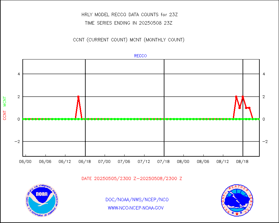
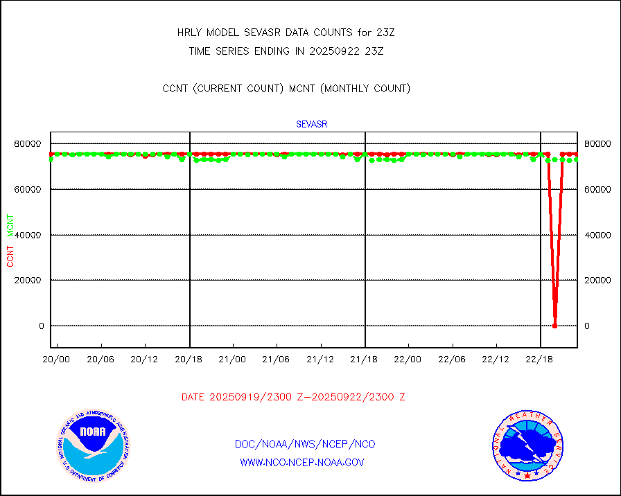
| Suspect Data Shortages in Critical Types - Monitor | ||||||||||||||
|---|---|---|---|---|---|---|---|---|---|---|---|---|---|---|
| Type | Description | Hourly Count | Monthly Average | Percent (%) of Monthly Mean | UTC Time Window | |||||||||
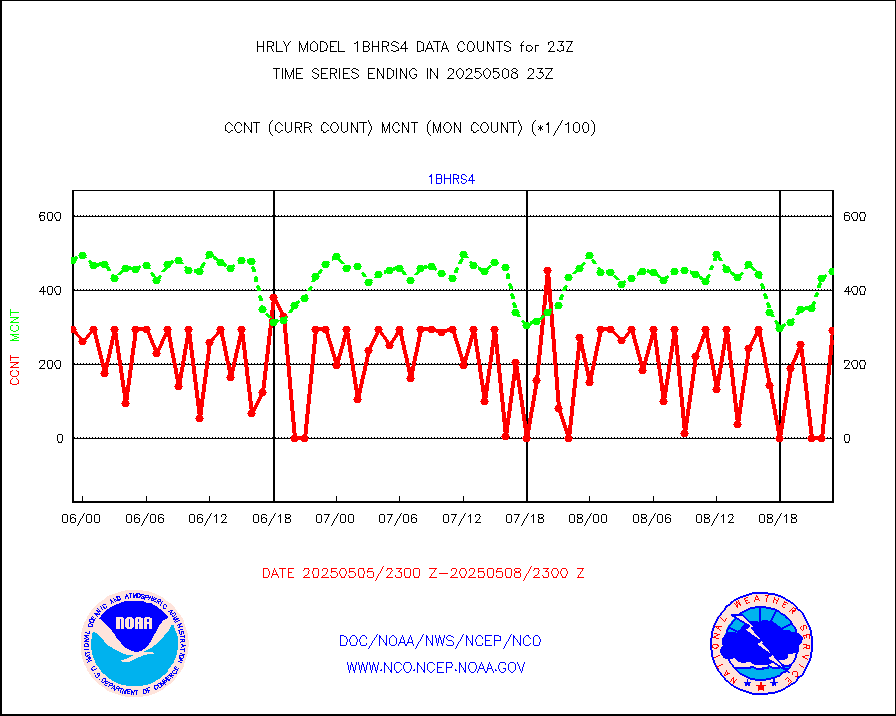
NOAA 18-19 & METOP 1-2 HIRS-4 NCEP-proc. br.temps |
0 |
12728 |
0.0 % |
3021.00-3021.99 |
||||||||||
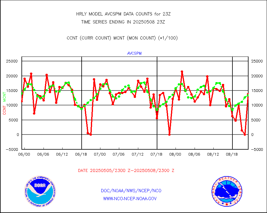
NOAA 15-19 & METOP 1-2 HIRS-3/4 pr btmps frm RARS |
0 |
9156 |
0.0 % |
3022.50-3023.49 |
||||||||||
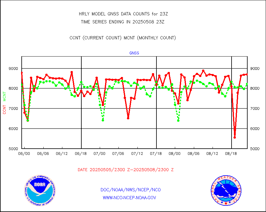
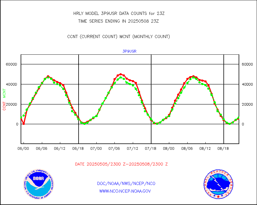
Grnd-based Gbl Navigation Sat System (GNSS) data |
1507 |
6368 |
23.7 % |
3022.00-3022.99 |
||||||||||
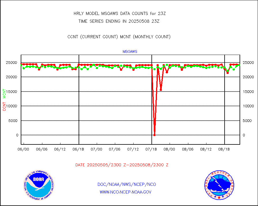
Mesonet/MADIS AWS Convergence Technologies, Inc. |
4508 |
19960 |
22.6 % |
3022.50-3023.49 |
||||||||||
| Shortage in Data Type of Opportunity - Monitor | ||||||||||||||
|---|---|---|---|---|---|---|---|---|---|---|---|---|---|---|
| Type | Description | Hourly Count | Monthly Average | Percent (%) of Monthly Mean | UTC Time Window | |||||||||
P.M.(N18-19) AVHRR GAC NCEP-proc clr & sea btemps |
0 |
443874 |
0.0 % |
3020.50-3021.49 |
||||||||||
NPP Adv. Tech. MW Sndr (ATMS) br. temps from RARS |
0 |
1312 |
0.0 % |
3021.50-3022.49 |
||||||||||
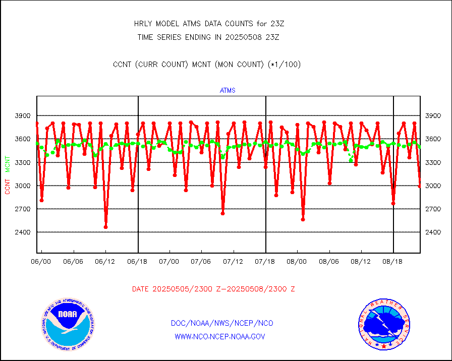
METOP 1-2 IASI 1C radiance data vbl chn from RARS |
0 |
7088 |
0.0 % |
3022.00-3022.99 |
||||||||||
INDIA SATWIND, INSAT WV channel |
0 |
567 |
0.0 % |
3022.00-3022.99 |
||||||||||
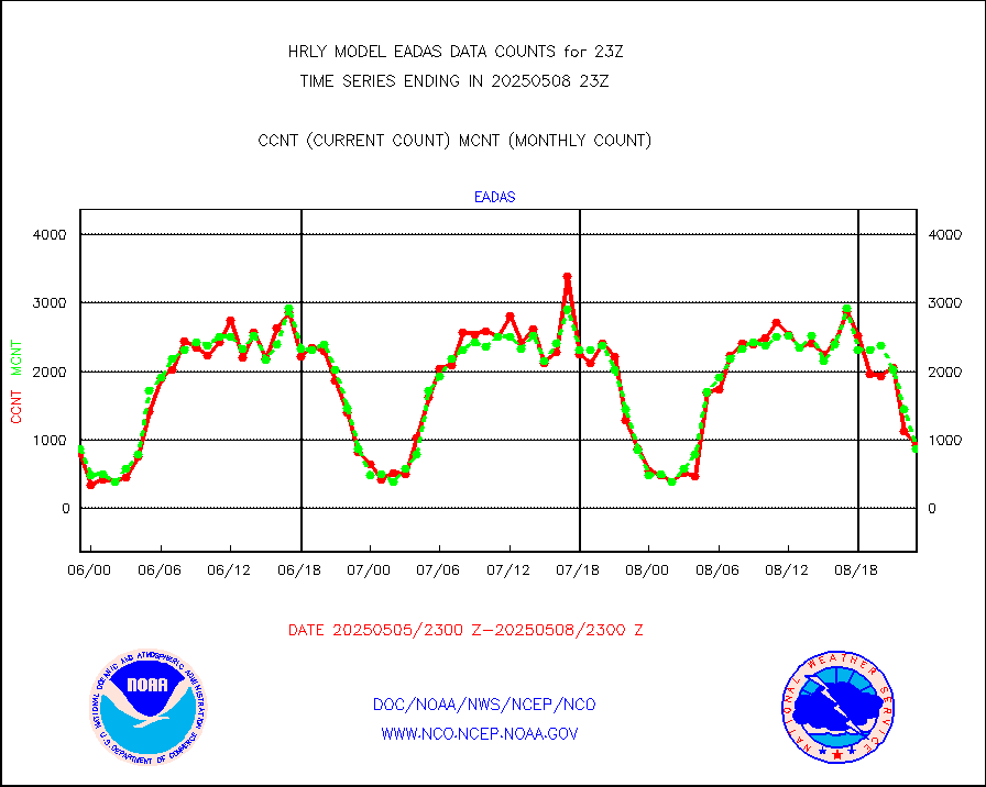
High Density OBs from reconnaissance acft data |
0 |
35 |
0.0 % |
3022.50-3023.49 |
||||||||||
INDIA SATWIND, INSAT IR channel |
0 |
910 |
0.0 % |
3022.00-3022.99 |
||||||||||
DMSP SSM/IS 1C radiance data (Unified Pre-Proc.) |
0 |
100220 |
0.0 % |
3021.50-3022.49 |
||||||||||
NPP/NOAA-20 VIIRS SST - CLEAR & OVER WATER |
0 |
1497581 |
0.0 % |
3022.50-3023.49 |
||||||||||
NPP/NOAA-20 VIIRS SST - PROBABLY CLR & OVER WATER |
0 |
365456 |
0.0 % |
3022.50-3023.49 |
||||||||||
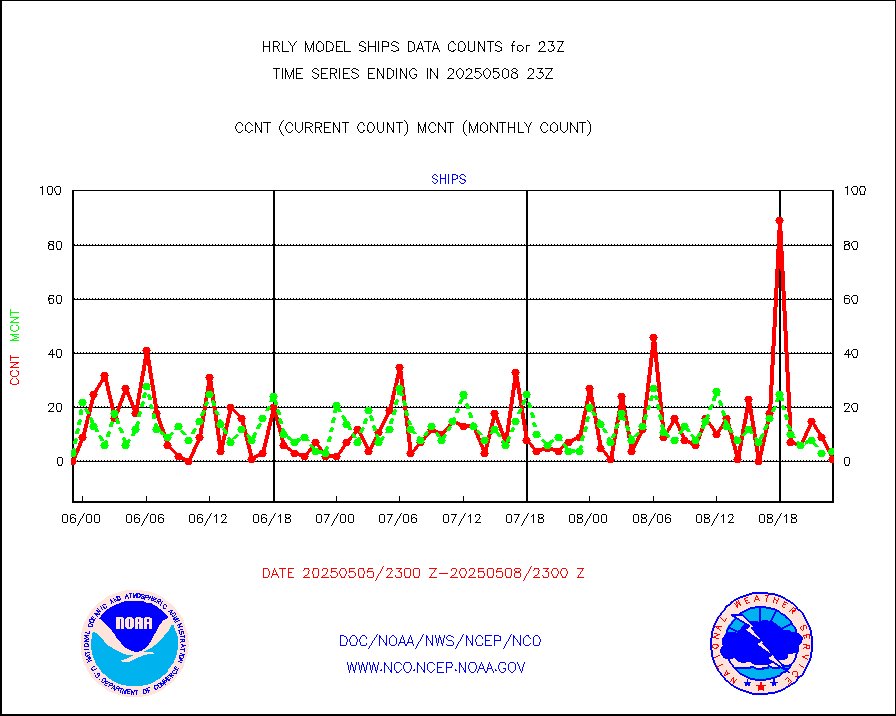
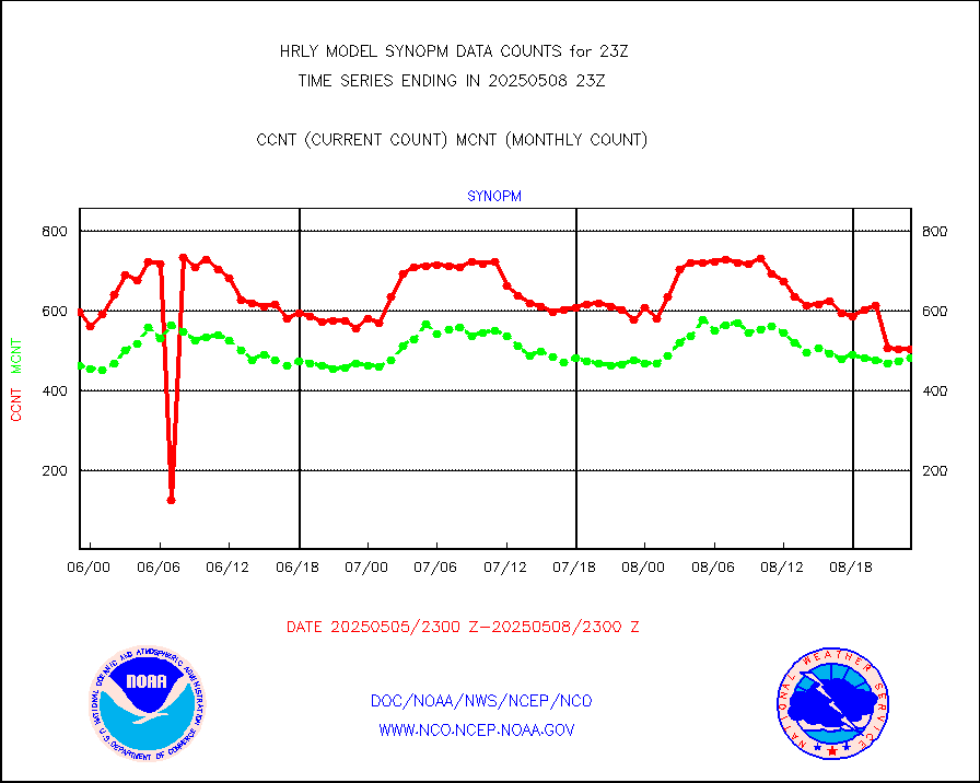
| Critical Data with Normal Counts | ||||||||||||||
|---|---|---|---|---|---|---|---|---|---|---|---|---|---|---|
| Type | Description | Hourly Count | Monthly Average | Percent (%) of Monthly Mean | UTC Time Window | |||||||||
NOAA 15-19 & METOP 1-2 AMSU-A NCEP-proc. br.temps |
26740 |
32717 |
81.7 % |
3021.00-3021.99 |
||||||||||
NOAA 18-19 & METOP 1-2 MHS NCEP-proces. br. temps |
238618 |
253315 |
94.2 % |
3021.00-3021.99 |
||||||||||
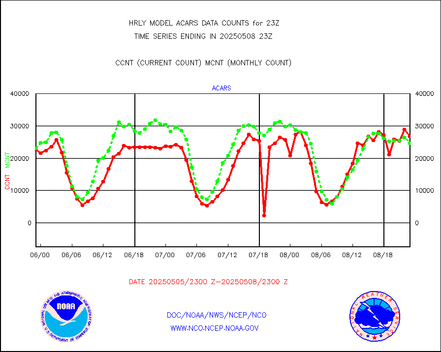
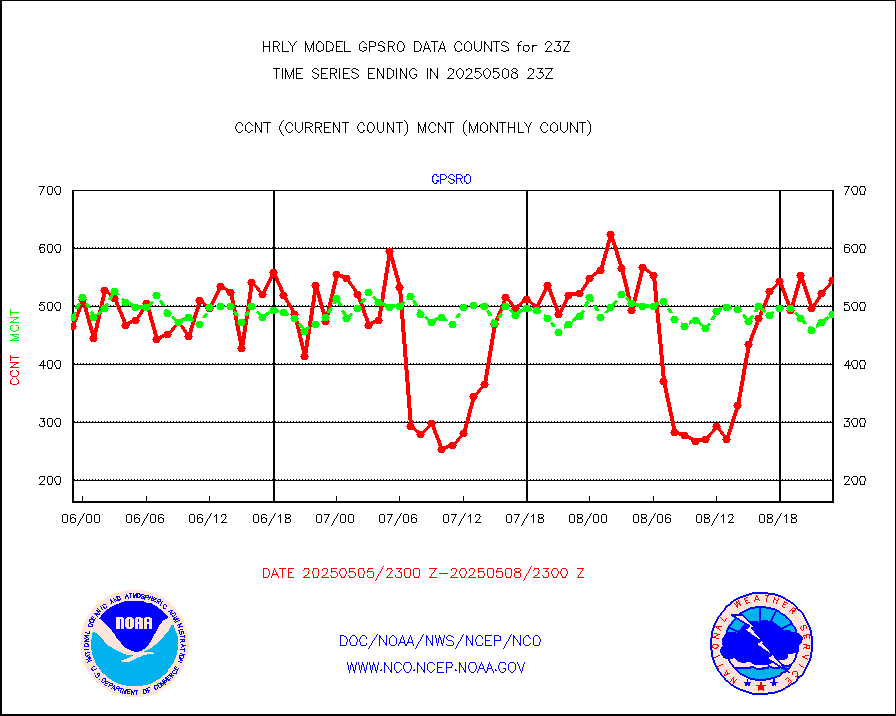
MDCRS ACARS acft data from ARINC(dcded from BUFR) |
25008 |
23300 |
107.3 % |
3022.50-3023.49 |
||||||||||
Manual AIREP aircraft data (dcded from AIREP fmt) |
251 |
251 |
100.0 % |
3022.50-3023.49 |
||||||||||
AQUA AIRS/AMSU-A/HSB brightness temps- every FOV |
0 |
0 |
n/a |
3020.50-3021.49 |
||||||||||
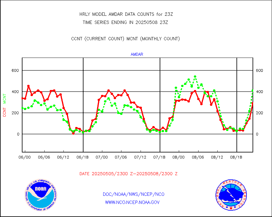
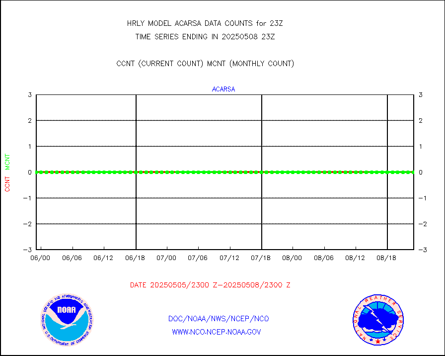
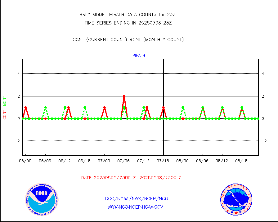
AMDAR aircraft data (decoded from AMDAR format) |
345 |
236 |
146.2 % |
3022.50-3023.49 |
||||||||||
AMDAR aircraft data (decoded from BUFR) |
1788 |
1946 |
91.9 % |
3022.50-3023.49 |
||||||||||
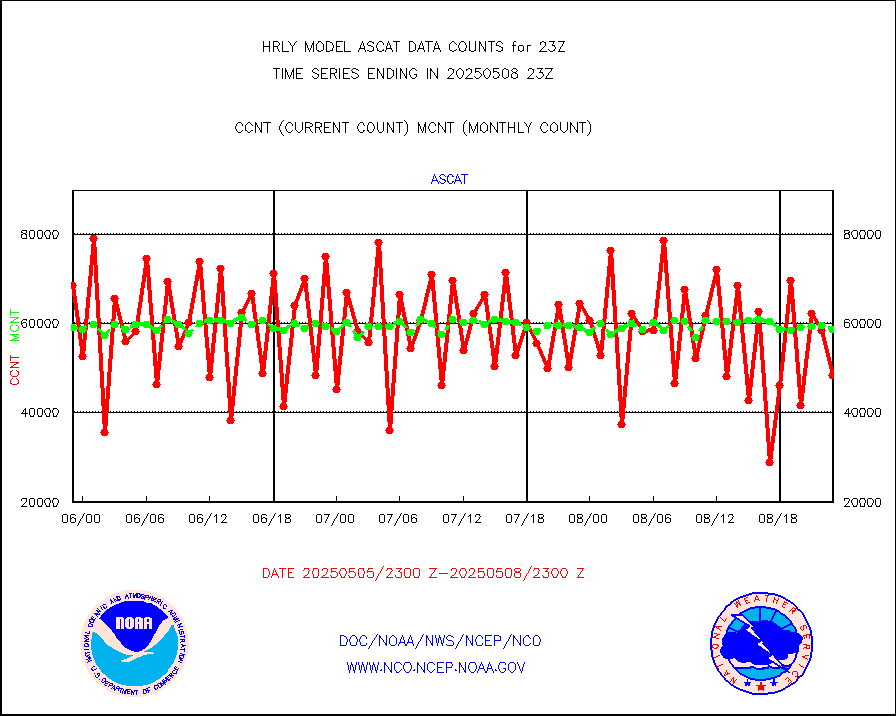
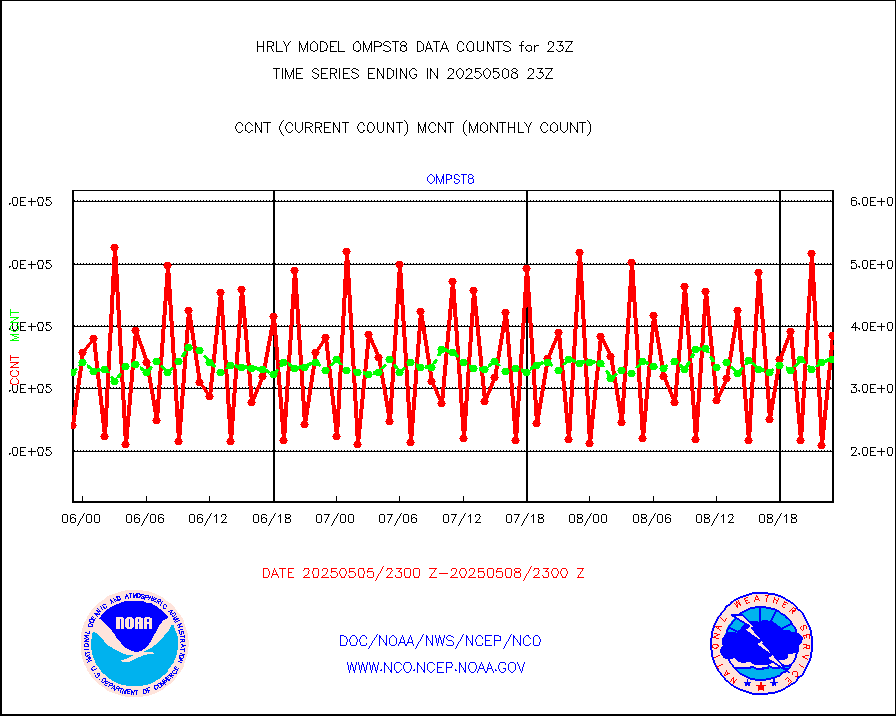
METOP 1-2 ASCAT products |
52500 |
58338 |
90.0 % |
3021.50-3022.49 |
||||||||||
NPP/NOAA-20 ATMS brightness temperatures |
307872 |
348224 |
88.4 % |
3021.50-3022.49 |
||||||||||
Canadian AMDAR aircraft data (decoded from BUFR) |
0 |
0 |
n/a |
3022.50-3023.49 |
||||||||||
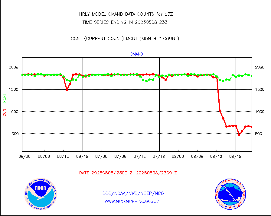
Surface Marine CMAN rpts decoded from BUFR format |
1864 |
1861 |
100.2 % |
3022.50-3023.50 |
||||||||||
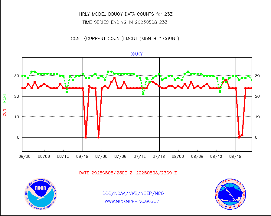
Buoys decoded from FM-18 fmt (moored or drifting) |
4 |
13 |
30.8 % |
3022.50-3023.49 |
||||||||||
E-AMDAR (European AMDAR acft decoded from BUFR) |
840 |
944 |
89.0 % |
3022.50-3023.49 |
||||||||||
NOAA 15-19 & METOP 1-2 AMSU-A proc btmps frm RARS |
20811 |
18199 |
114.4 % |
3022.50-3023.49 |
||||||||||
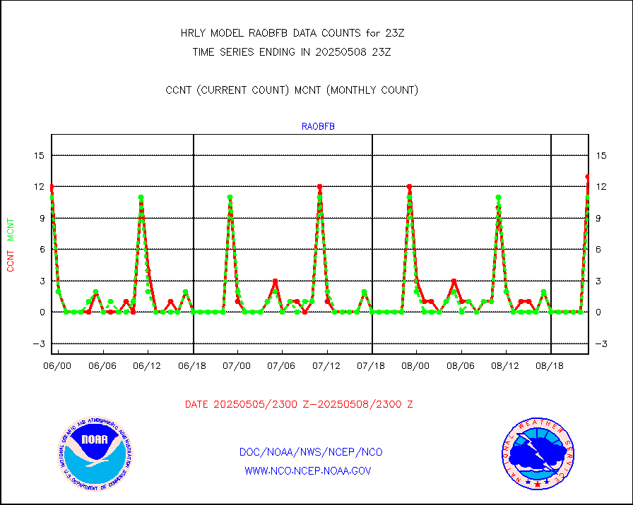
GPS radio occultation data |
495 |
500 |
99.0 % |
3020.50-3021.49 |
||||||||||
GOES-16/17 All Sky Radiances (proc.) |
720952 |
714775 |
100.9 % |
3022.50-3023.49 |
||||||||||
GOES-16/17 Clear Sky Radiances (proc.) |
367349 |
372193 |
98.7 % |
3022.50-3023.49 |
||||||||||
MTSAT/JMA water vapor imager derived cloud motion |
20403 |
19208 |
106.2 % |
3020.50-3021.49 |
||||||||||
MODIS (AQUA/TERRA) wvpr imager derived cld motion |
0 |
0 |
n/a |
3019.00-3019.99 |
||||||||||
GOES-16&up/NESDIS wv imgr/cld-top derived cld mtn |
30044 |
30552 |
98.3 % |
3022.00-3022.99 |
||||||||||
METEOSAT/EUMETSAT ir lg-wave drv cld motion NBseq |
21037 |
20900 |
100.7 % |
3021.50-3022.49 |
||||||||||
MTSAT/JMA infrared long-wave derived cloud motion |
16366 |
15865 |
103.2 % |
3020.50-3021.49 |
||||||||||
MODIS (AQUA/TERRA) ir l-wave derived cloud motion |
0 |
0 |
n/a |
3019.00-3019.99 |
||||||||||
GOES-16&up/NESDIS ir long-wave derived cld motion |
84343 |
84116 |
100.3 % |
3022.00-3022.99 |
||||||||||
GOES/NASA(Langley) hi-res. (1x1 f-o-v) cloud data |
6428468 |
6393928 |
100.5 % |
3022.50-3023.49 |
||||||||||
Buoys decoded from FM-13 format (moored) |
123 |
124 |
99.2 % |
3022.50-3023.49 |
||||||||||
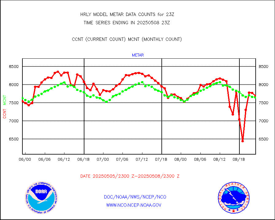
Aviation - METAR |
7798 |
7681 |
101.5 % |
3022.50-3023.49 |
||||||||||
Mesonet/MADIS Colorado E-470 (Interstate 470) |
24 |
24 |
100.0 % |
3022.50-3023.49 |
||||||||||
Mesonet/MADIS Alaska Department of Transportation |
116 |
101 |
114.9 % |
3022.50-3023.49 |
||||||||||
Mesonet/MADIS U.S. Army Aberdeen Proving Grounds |
0 |
0 |
n/a |
3022.50-3023.49 |
||||||||||
Mesonet/MADIS Citizen Weather Observers Program |
59941 |
60298 |
99.4 % |
3022.50-3023.49 |
||||||||||
Mesonet/MADIS "Anything Weather" |
0 |
0 |
n/a |
3022.50-3023.49 |
||||||||||
Mesonet/MADIS Colorado Dept. of Transportation |
0 |
0 |
n/a |
3022.50-3023.49 |
||||||||||
Mesonet/MADIS DC Net |
0 |
0 |
n/a |
3022.50-3023.49 |
||||||||||
Mesonet/MADIS Denver Urban Drainage & Flood Cntrl |
0 |
0 |
n/a |
3022.50-3023.49 |
||||||||||
Mesonet/MADIS Florida (FAWN & USF) |
3 |
4 |
75.0 % |
3022.50-3023.49 |
||||||||||
Mesonet/MADIS Florida Dept. of Transportation |
0 |
0 |
n/a |
3022.50-3023.49 |
||||||||||
Mesonet/MADIS Georgia Dept. of Transportation |
0 |
0 |
n/a |
3022.50-3023.49 |
||||||||||
Mesonet/MADIS NWS Hydromet Auto Data System(HADS) |
5427 |
6123 |
88.6 % |
3022.50-3023.49 |
||||||||||
Mesonet/MADIS Iowa Environmental |
182 |
185 |
98.4 % |
3022.50-3023.49 |
||||||||||
Mesonet/MADIS Indiana Dept. of Transportation |
0 |
0 |
n/a |
3022.50-3023.49 |
||||||||||
Mesonet/MADIS Iowa Department of Transportation |
0 |
0 |
n/a |
3022.50-3023.49 |
||||||||||
Mesonet/MADIS Kansas Department of Transportation |
426 |
362 |
117.7 % |
3022.50-3023.49 |
||||||||||
Mesonet/MADIS Oklahoma Mesonet |
630 |
620 |
101.6 % |
3022.50-3023.49 |
||||||||||
Mesonet/MADIS Louisiana State/Jackson State Univ. |
0 |
0 |
n/a |
3022.50-3023.49 |
||||||||||
Mesonet/MADIS Missouri Commercial Agricult Wx Net |
316 |
333 |
94.9 % |
3022.50-3023.49 |
||||||||||
Mesonet/MADIS Minnesota Dept. of Transportation |
0 |
0 |
n/a |
3022.50-3023.49 |
||||||||||
Mesonet/MADIS NOS-Phys Oceanographic Realtime Sys |
348 |
371 |
93.8 % |
3022.50-3023.49 |
||||||||||
Mesonet/MADIS NFIC Remote Automated Wx Stns(RAWS) |
1823 |
1839 |
99.1 % |
3022.50-3023.49 |
||||||||||
Mesonet/MADIS many providers, not separated out |
73139 |
71403 |
102.4 % |
3022.00-3023.49 |
||||||||||
Mesonet/MADIS Virginia Dept. of Transportation |
0 |
0 |
n/a |
3022.50-3023.49 |
||||||||||
Mesonet/MADIS "Weather for You" |
0 |
0 |
n/a |
3022.50-3023.49 |
||||||||||
Mesonet/MADIS Wisconsin Dept. of Transportation |
0 |
0 |
n/a |
3022.50-3023.49 |
||||||||||
Mesonet/MADIS MesoWest (many subproviders) |
37121 |
35753 |
103.8 % |
3022.50-3023.49 |
||||||||||
Mesonet/MADIS West Texas |
5863 |
6078 |
96.5 % |
3022.50-3023.49 |
||||||||||
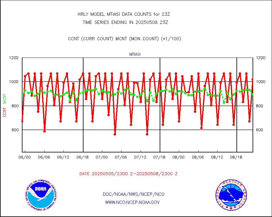
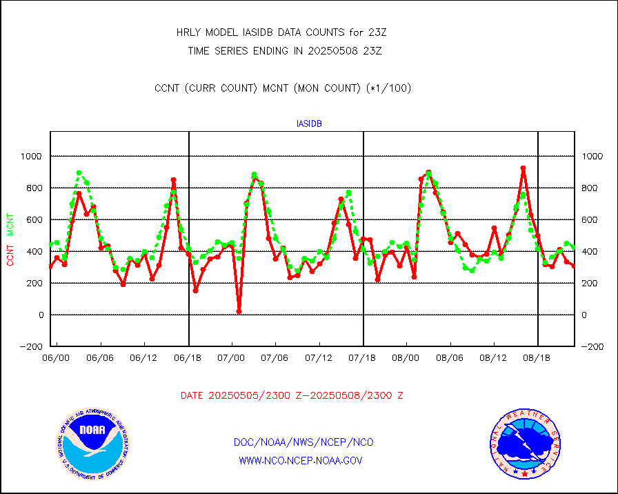
METOP 1-2 IASI 1C radiance data (varbl. channels) |
106924 |
87008 |
122.9 % |
3021.00-3021.99 |
||||||||||
NEXRAD Vel Azm Dsp(VAD) winds via radar coded msg |
0 |
0 |
n/a |
3022.50-3023.49 |
||||||||||
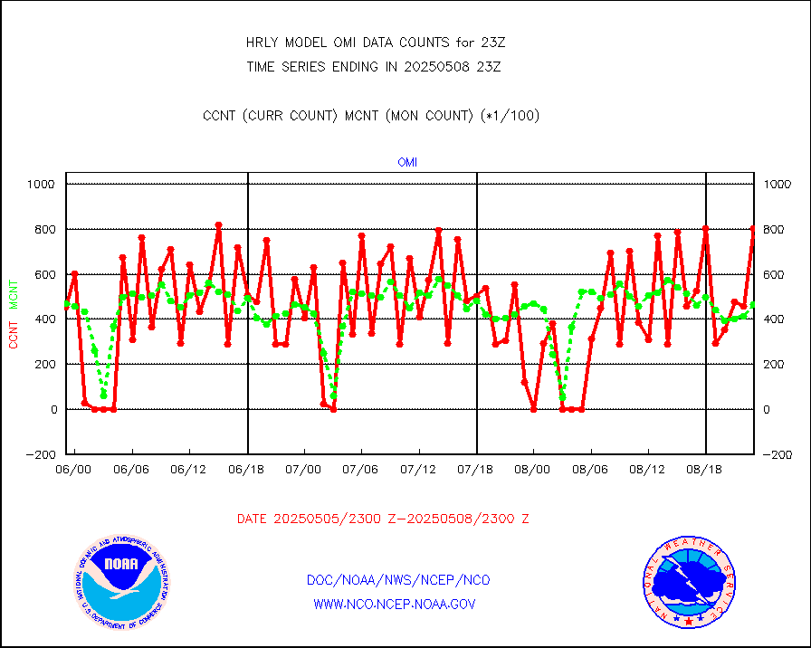
Aura Ozone Monitoring Instrument (OMI) data |
0 |
0 |
n/a |
3020.50-3021.49 |
||||||||||
NOAA 16-19 Solar Backscatter UV-2 rad frm V8 BUFR |
0 |
0 |
n/a |
3021.00-3021.99 |
||||||||||
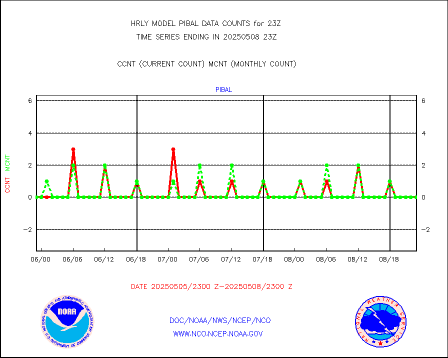
PIBAL (from PILOT, PILOT SHIP, PILOT MOBIL) |
0 |
0 |
n/a |
3022.50-3023.49 |
||||||||||
Multi-Agency Profiler (MAP) and SODAR winds |
46 |
45 |
102.2 % |
3022.50-3023.49 |
||||||||||
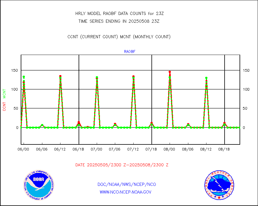
Rawinsonde - fixed land (from TEMP or PILOT) |
0 |
0 |
n/a |
3022.50-3023.49 |
||||||||||
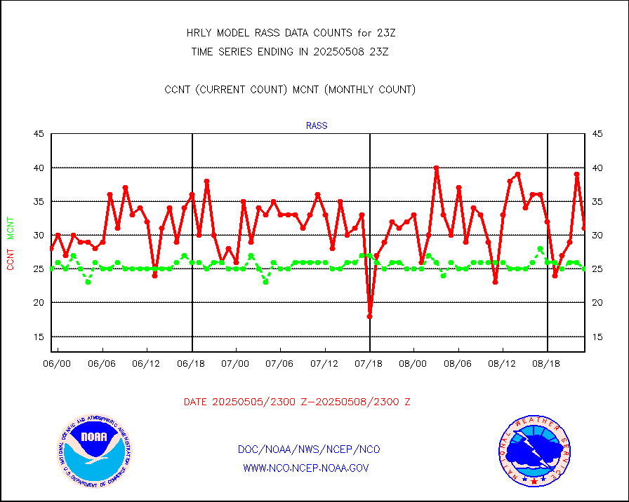
RASS temperatures (NOAA and Multi-Agency) |
20 |
22 |
90.9 % |
3022.50-3023.49 |
||||||||||
NEXRAD reflectivity (Lvl 2 - GTS) |
4998910 |
4693529 |
106.5 % |
3022.50-3023.49 |
||||||||||
NEXRAD radial wind (Level 2 - GTS) |
2241376 |
1793259 |
125.0 % |
3022.50-3023.49 |
||||||||||
METEOSAT-10 2nd Gen SEVIRI Clr Sky Radiance(proc) |
0 |
0 |
n/a |
3022.50-3023.49 |
||||||||||
Ship - manual and automatic, restricted (BUFR) |
0 |
1 |
0.0 % |
3022.50-3023.50 |
||||||||||
Ship - manual and automatic, unrestricted |
147 |
142 |
103.5 % |
3022.50-3023.50 |
||||||||||
Ship - manual and automatic, unrestricted (BUFR) |
913 |
949 |
96.2 % |
3022.50-3023.50 |
||||||||||
Synoptic - fixed manual and automatic |
787 |
736 |
106.9 % |
3022.50-3023.49 |
||||||||||
Synoptic - fixed manual & auto (decoded fr BUFR) |
5107 |
5223 |
97.8 % |
3022.50-3023.49 |
||||||||||
Synoptic - restricted (WMO Res 40) manual & auto. |
0 |
0 |
n/a |
3022.50-3023.49 |
||||||||||
Synoptic - restricted (WMO Res 40)(decoded BUFR) |
400 |
411 |
97.3 % |
3022.50-3023.49 |
||||||||||
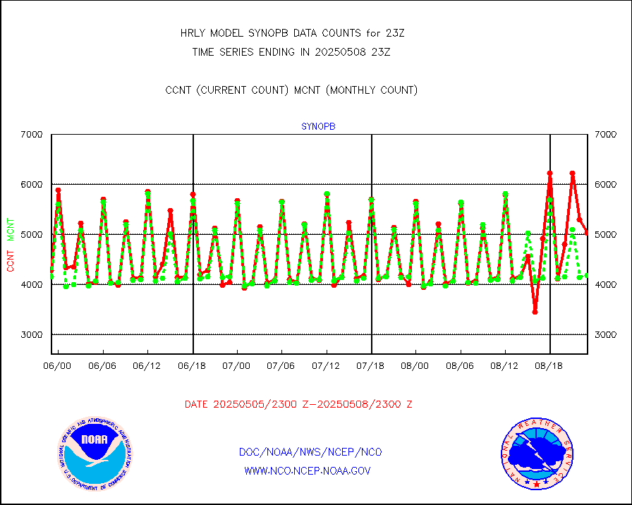
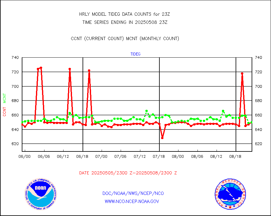
Tide gauge reports decoded from CREX format |
658 |
655 |
100.5 % |
3022.00-3022.99 |
||||||||||
| Data Types of Opportunity with Normal Counts | ||||||||||||||
|---|---|---|---|---|---|---|---|---|---|---|---|---|---|---|
| Type | Description | Hourly Count | Monthly Average | Percent (%) of Monthly Mean | UTC Time Window | |||||||||
GOES-16&up/NESDIS ir short-wv derived cld motion |
6671 |
7330 |
91.0 % |
3022.00-3022.99 |
||||||||||
MDCRS ACARS acft data (ARINC via AFWA)(AIREP fmt) |
0 |
0 |
n/a |
3022.50-3023.49 |
||||||||||
Himawari Clear Sky Radiance |
0 |
0 |
n/a |
3022.00-3022.99 |
||||||||||
GCOM-W AMSR2 1B brightness temperatures |
2309472 |
2120742 |
108.9 % |
3021.00-3021.99 |
||||||||||
NPP/NOAA-20 ATMS bright. temps-direct b-cast SSEC |
109998 |
111534 |
98.6 % |
3021.50-3022.49 |
||||||||||
POES/NESDIS - processed ATOVS soundings/radiances |
0 |
0 |
n/a |
3021.00-3021.99 |
||||||||||
A.M.(N17,M2,M3) AVHRR GAC NCEP-proc clr&sea btmps |
1143012 |
1251067 |
91.4 % |
3020.50-3021.49 |
||||||||||
eXpendable BathyThermograph, mooring (BATHY fmt) |
0 |
0 |
n/a |
3016.00-3016.99 |
||||||||||
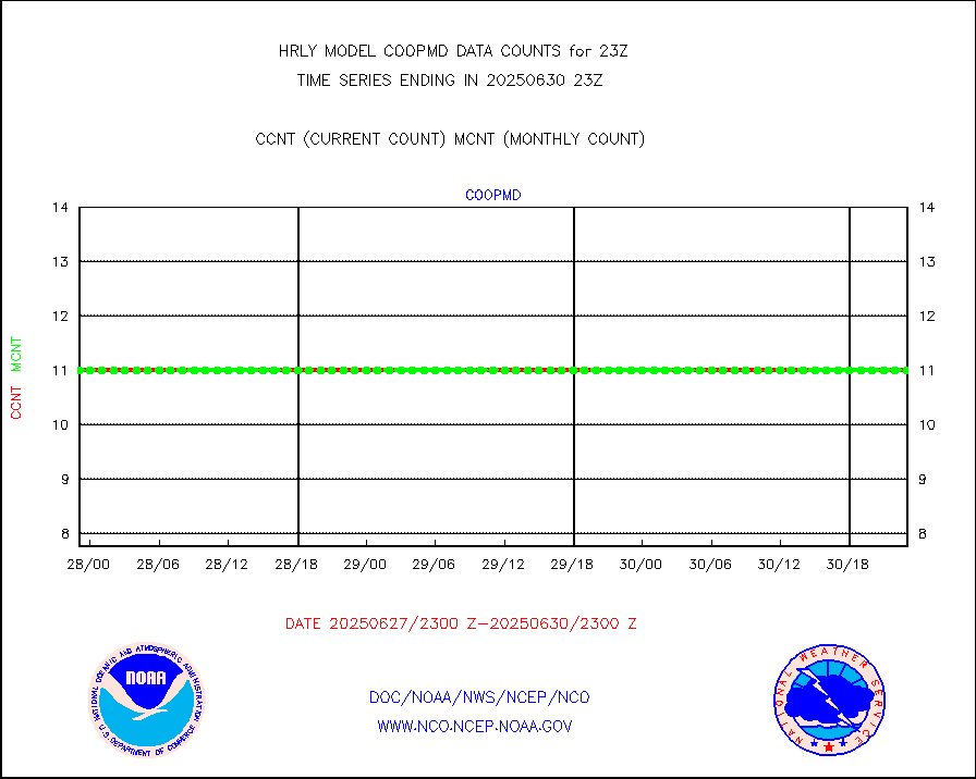
Coop/MADIS NEPP & HCN-Modernization NOAA COOP Obs |
11 |
11 |
100.0 % |
3022.50-3023.49 |
||||||||||
NPP/NOAA-20 CrIS full spctrl radn (431 ch subset) |
231156 |
224030 |
103.2 % |
3021.50-3022.49 |
||||||||||
NPP/NOAA-20 CrIS full spctrl radn dir brdcst SSEC |
41580 |
37121 |
112.0 % |
3021.50-3022.49 |
||||||||||
Coast Guard |
9 |
8 |
112.5 % |
3022.50-3023.50 |
||||||||||
Drifting buoys (decoded from BUFR) |
1456 |
1452 |
100.3 % |
3022.50-3023.50 |
||||||||||
Dropwinsonde (from TEMP DROP) |
0 |
0 |
n/a |
3022.50-3023.49 |
||||||||||
Dropwinsonde (decoded from BUFR) |
0 |
0 |
n/a |
3022.51-3023.49 |
||||||||||
GOES imager effective cloud amount data (U.Wisc.) |
8535568 |
8044879 |
106.1 % |
3022.50-3023.49 |
||||||||||
NOAA 18-19 & METOP 1-2 MHS proc. btemps from RARS |
162543 |
171768 |
94.6 % |
3022.50-3023.49 |
||||||||||
GOES/NESDIS (11x17 f-o-v) imager clear radiances |
0 |
0 |
n/a |
3022.00-3022.99 |
||||||||||
METOP 1-2 Global Ozone Monitoring Exp.-2 (GOME-2) |
5855 |
8523 |
68.7 % |
3021.50-3022.49 |
||||||||||
GOES-16&up/NESDIS wv imgr/deep-lyr derivd cld mtn |
20410 |
17475 |
116.8 % |
3022.00-3022.99 |
||||||||||
METEOSAT/EUMETSAT wvpr imgr drv cld motion NBseq |
36021 |
37068 |
97.2 % |
3021.50-3022.49 |
||||||||||
METOP 1-2 IASI 1C radiances-direct broadcast SSEC |
21960 |
49467 |
44.4 % |
3021.50-3022.49 |
||||||||||
VIIRS (NPP/NOAA-20) ir lg-wv drv cloud motion(NB) |
14391 |
17156 |
83.9 % |
3019.00-3019.99 |
||||||||||
AVHRR (NOAA/METOP) ir lg-wave derived cld motion |
0 |
0 |
n/a |
3019.00-3019.99 |
||||||||||
AVHRR (METOP) ir lg-wave derived cld motion |
0 |
0 |
n/a |
3022.50-3023.50 |
||||||||||
INSAT/KALPANA India ir lg-wave derived cld motion |
0 |
0 |
n/a |
3020.50-3021.49 |
||||||||||
Korean AMDAR aircraft data (decoded from BUFR) |
68 |
86 |
79.1 % |
3022.50-3023.49 |
||||||||||
Land-based CMAN stations decoded from CMAN format |
68 |
76 |
89.5 % |
3022.50-3023.49 |
||||||||||
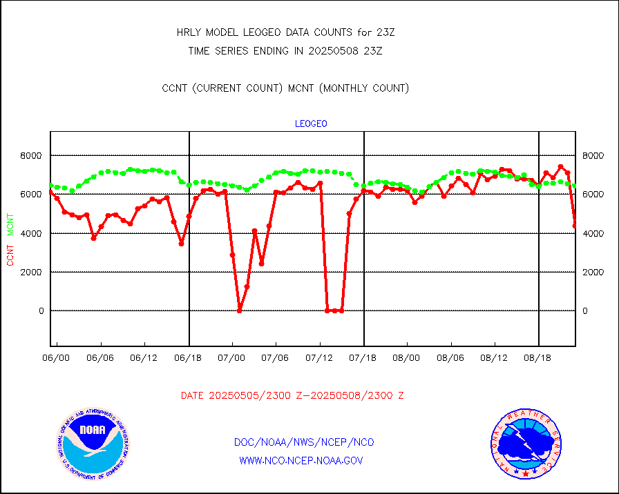
LEO-GEO satellite AMVs from UWisc. |
6651 |
7287 |
91.3 % |
3019.00-3019.99 |
||||||||||
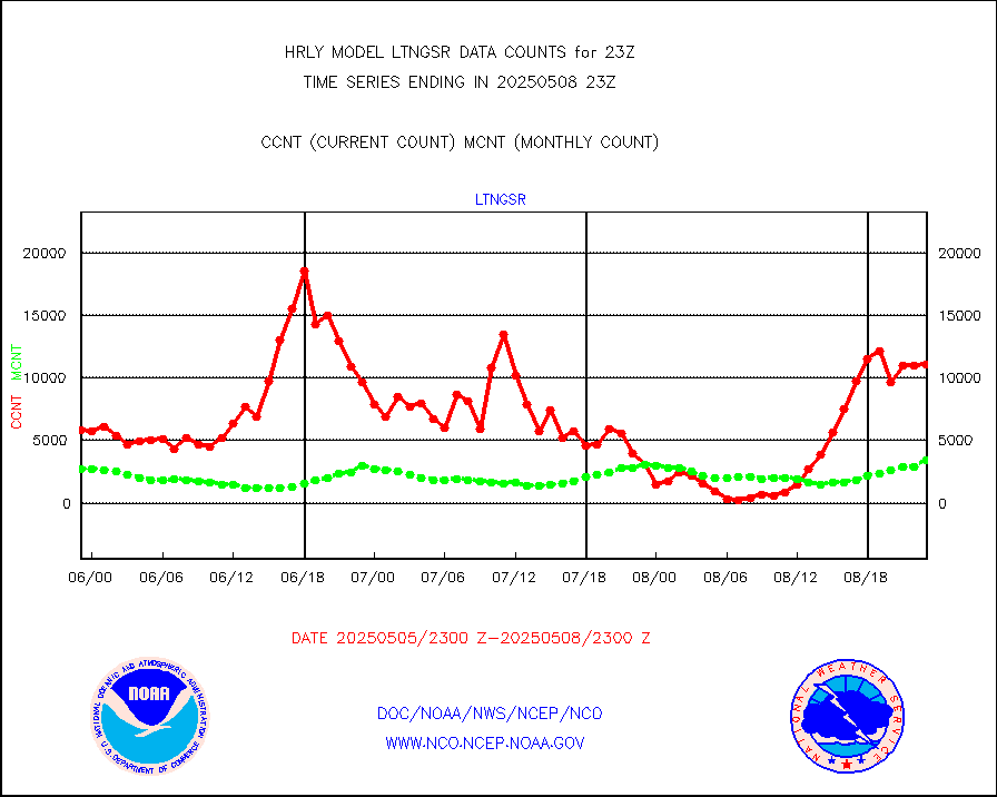
LLDN Long-rng lightning from Vaisala via NOAAPORT |
267388 |
247569 |
108.0 % |
3022.50-3023.49 |
||||||||||
NLDN Shrt-rng lightning from Vaisala via NOAAPORT |
13561 |
10561 |
128.4 % |
3022.50-3023.49 |
||||||||||
Moored buoys (decoded from BUFR) |
971 |
927 |
104.7 % |
3022.50-3023.50 |
||||||||||
Aura Microwave Limb Sounder (MLS) ozone data |
0 |
0 |
n/a |
3021.00-3021.99 |
||||||||||
Mesonet/MADIS UrbaNet |
3590 |
3610 |
99.4 % |
3022.50-3023.49 |
||||||||||
NEXRAD Vel Azm Dsp(VAD) winds via Level 2 decoder |
466 |
460 |
101.3 % |
3022.50-3023.49 |
||||||||||
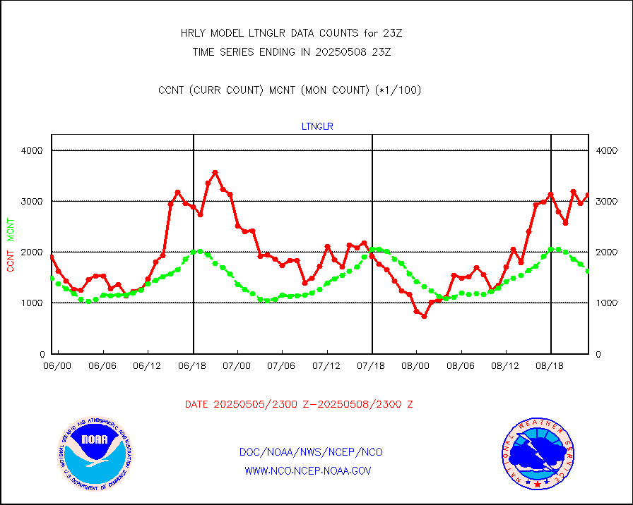
OMPS Limb Profiler ozone data (NPP) |
361 |
259 |
139.4 % |
3016.00-3016.99 |
||||||||||
OMPS nadir profile ozone (Version 8 BUFR) |
619 |
559 |
110.7 % |
3021.00-3021.99 |
||||||||||
OMPS total column ozone (Version 8 BUFR) |
445667 |
346248 |
128.7 % |
3021.00-3021.99 |
||||||||||
PIBAL (decoded from BUFR) |
0 |
0 |
n/a |
3022.51-3023.49 |
||||||||||
Manual PIREP aircraft data (dcded from AIREP fmt) |
76 |
95 |
80.0 % |
3022.50-3023.49 |
||||||||||
Profilr winds from PIBAL (PILOT,PILOT SHIP/MOBIL) |
0 |
0 |
n/a |
3022.50-3023.49 |
||||||||||
Rawinsonde - fixed land (decoded from BUFR) |
14 |
12 |
116.7 % |
3022.51-3023.49 |
||||||||||
Rawinsonde - mobile land (from TEMP/PILOT MOBIL) |
0 |
0 |
n/a |
3022.50-3023.49 |
||||||||||
Rawinsonde - mobile land (decoded from BUFR) |
0 |
0 |
n/a |
3022.51-3023.49 |
||||||||||
Rawinsonde - ship (from TEMP SHIP, PILOT SHIP) |
0 |
0 |
n/a |
3022.50-3023.49 |
||||||||||
Rawinsonde - ship (decoded from BUFR) |
0 |
0 |
n/a |
3022.51-3023.49 |
||||||||||
Flight level reconnaissance aircraft data |
0 |
0 |
n/a |
3022.50-3023.49 |
||||||||||
Megha-Tropiques SAPHIR L1A2 brightness temps |
0 |
0 |
n/a |
3020.50-3021.49 |
||||||||||
METEOSAT-10 2nd Gen SEVIRI All Sky Radiance(proc) |
75062 |
75369 |
99.6 % |
3022.50-3023.49 |
||||||||||
Ship - manual and automatic, restricted |
5 |
5 |
100.0 % |
3022.50-3023.49 |
||||||||||
Synoptic - mobile manual and automatic |
660 |
642 |
102.8 % |
3022.50-3023.49 |
||||||||||
Synoptic - mobile manual & auto (decoded fr BUFR) |
1 |
1 |
100.0 % |
3022.50-3023.49 |
||||||||||
CTD probe, Argo prflng float, mooring (TESAC fmt) |
219 |
220 |
99.5 % |
3022.50-3023.49 |
||||||||||
TAMDAR aircft data-all types(from Panasonic,BUFR) |
33 |
51 |
64.7 % |
3022.50-3023.49 |
||||||||||
ThermoSalinoGraph (TSG) TRACKOB format) |
60 |
92 |
65.2 % |
3021.50-3022.49 |
||||||||||
INSAT/KALPANA India visible derived cloud motion |
0 |
0 |
n/a |
3020.50-3021.49 |
||||||||||
INDIA SATWIND, INSAT VIS channel |
0 |
0 |
n/a |
3022.00-3022.99 |
||||||||||
MTSAT/JMA visible derived cloud motion |
5772 |
5449 |
105.9 % |
3020.50-3021.49 |
||||||||||
GOES-16&up/NESDIS visible derived cloud motion |
502175 |
438903 |
114.4 % |
3022.00-3022.99 |
||||||||||
METEOSAT/EUMETSAT visible drv cld motion NBseq |
459 |
245 |
187.3 % |
3021.50-3022.49 |
||||||||||


