| Suspect Data Shortages in Critical Types - Monitor | ||||||||||||||
|---|---|---|---|---|---|---|---|---|---|---|---|---|---|---|
| Type | Description | Hourly Count | Monthly Average | Percent (%) of Monthly Mean | UTC Time Window | |||||||||
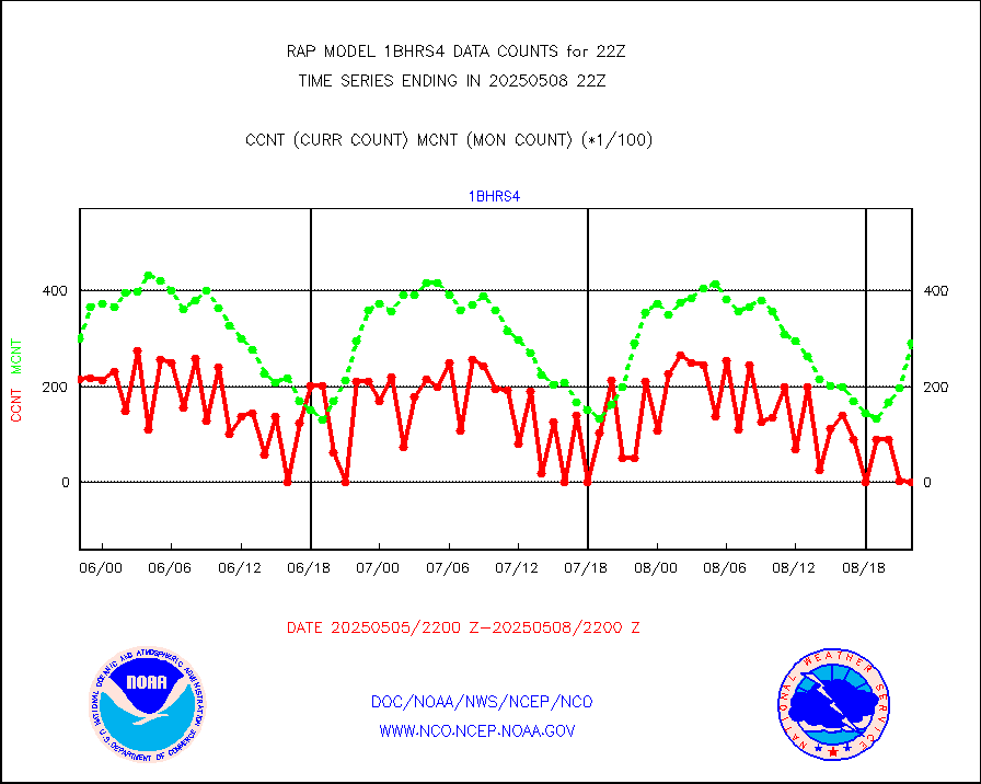
NOAA 18-19 & METOP 1-2 HIRS-4 NCEP-proc. br.temps |
0 |
9083 |
0.0 % |
3019.00-0100.99 |
||||||||||
| Shortage in Data Type of Opportunity - Monitor | ||||||||||||||
|---|---|---|---|---|---|---|---|---|---|---|---|---|---|---|
| Type | Description | Hourly Count | Monthly Average | Percent (%) of Monthly Mean | UTC Time Window | |||||||||
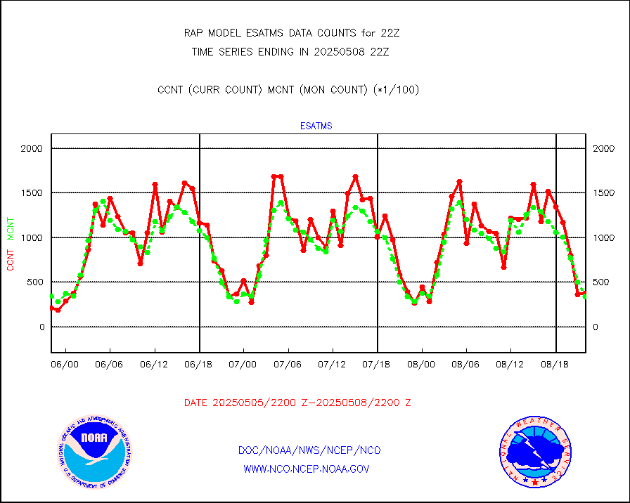
NPP Adv. Tech. MW Sndr (ATMS) br. temps from RARS |
0 |
3328 |
0.0 % |
3020.00-3023.99 |
||||||||||
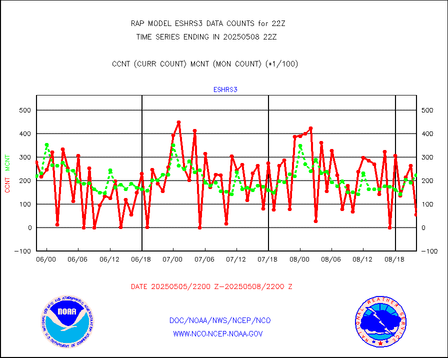
NOAA 15-19 & METOP 1-2 HIRS-3/4 pr btmps frm RARS |
0 |
5709 |
0.0 % |
3021.00-3023.00 |
||||||||||
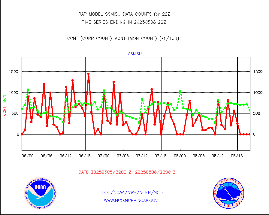
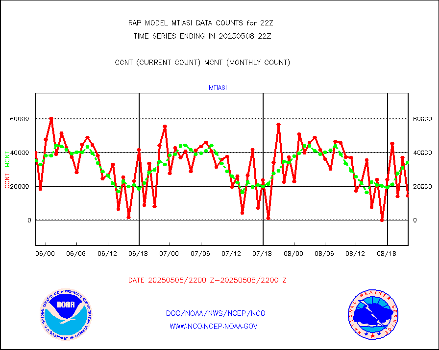
METOP 1-2 IASI 1C radiance data vbl chn from RARS |
0 |
7931 |
0.0 % |
3020.00-3023.99 |
||||||||||
Mesonet/MADIS AWS Convergence Technologies, Inc. |
5043 |
20415 |
24.7 % |
3021.50-3022.50 |
||||||||||
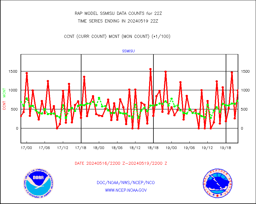
DMSP SSM/IS 1C radiance data (Unified Pre-Proc.) |
0 |
62613 |
0.0 % |
3020.00-3023.99 |
||||||||||
| Critical Data with Normal Counts | ||||||||||||||
|---|---|---|---|---|---|---|---|---|---|---|---|---|---|---|
| Type | Description | Hourly Count | Monthly Average | Percent (%) of Monthly Mean | UTC Time Window | |||||||||
NOAA 15-19 & METOP 1-2 AMSU-A NCEP-proc. br.temps |
13858 |
26437 |
52.4 % |
3019.00-0100.99 |
||||||||||
NOAA 18-19 & METOP 1-2 MHS NCEP-proces. br. temps |
123732 |
198843 |
62.2 % |
3019.00-0100.99 |
||||||||||
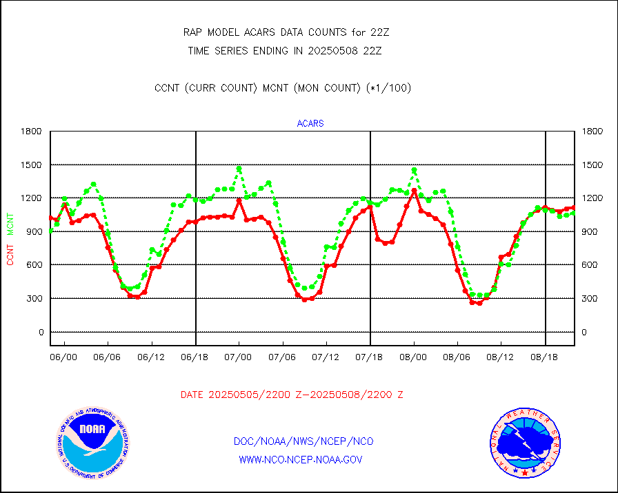
MDCRS ACARS acft data from ARINC(dcded from BUFR) |
113066 |
91867 |
123.1 % |
3018.75-0101.25 |
||||||||||
Canadian AMDAR aircraft data (decoded from BUFR) |
0 |
0 |
n/a |
3018.75-0101.25 |
||||||||||
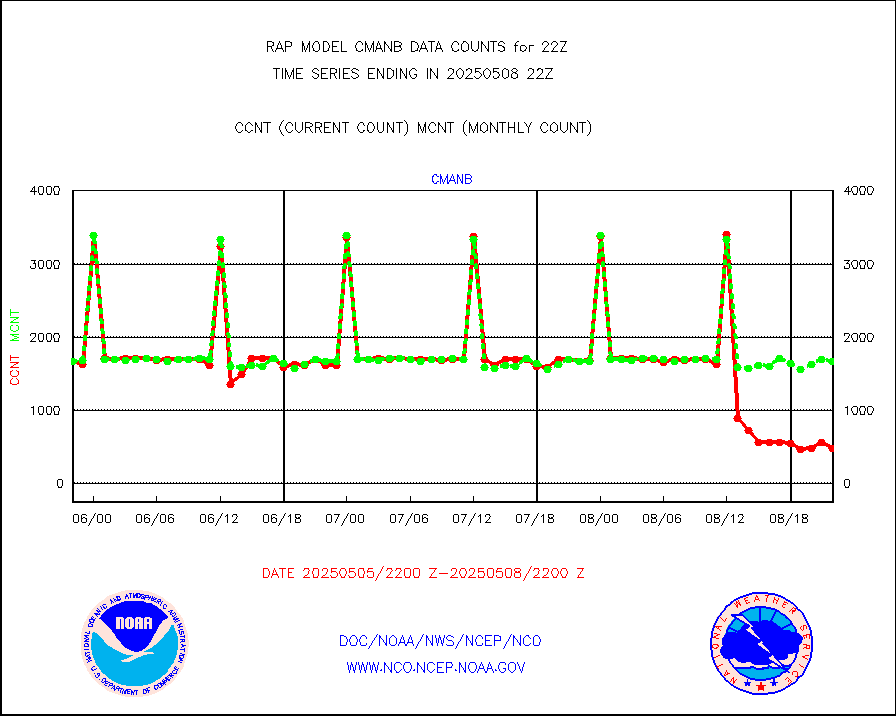
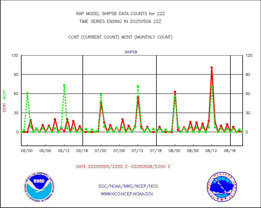
Surface Marine CMAN rpts decoded from BUFR format |
1724 |
1682 |
102.5 % |
3021.50-3022.50 |
||||||||||
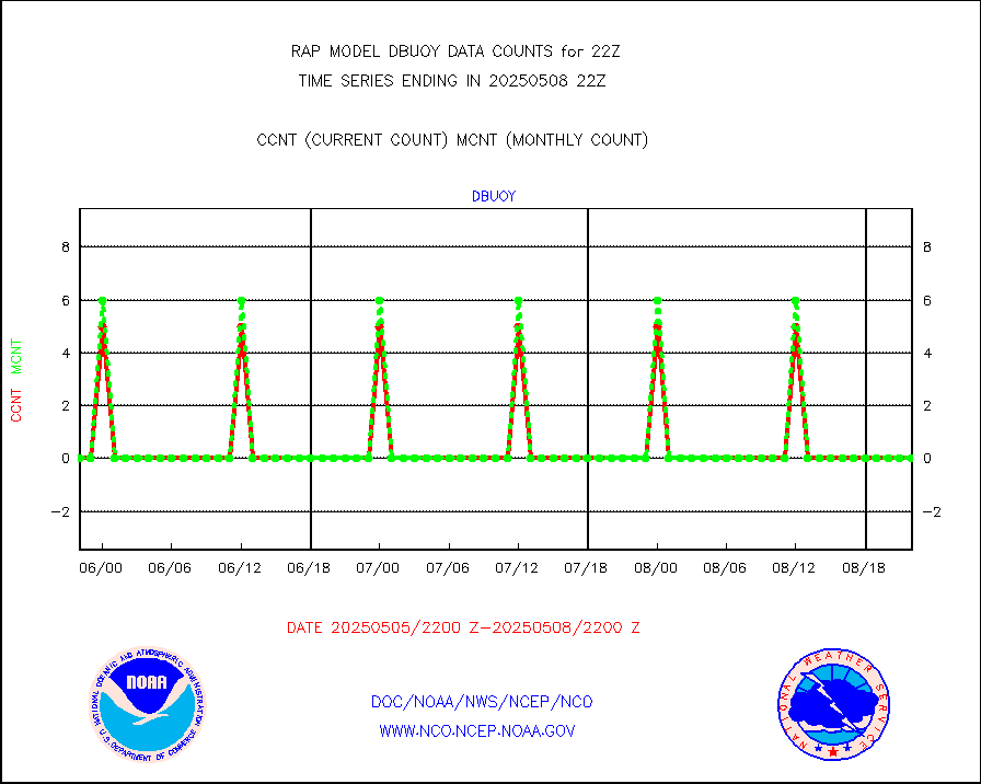
Buoys decoded from FM-18 fmt (moored or drifting) |
0 |
0 |
n/a |
3021.50-3022.50 |
||||||||||
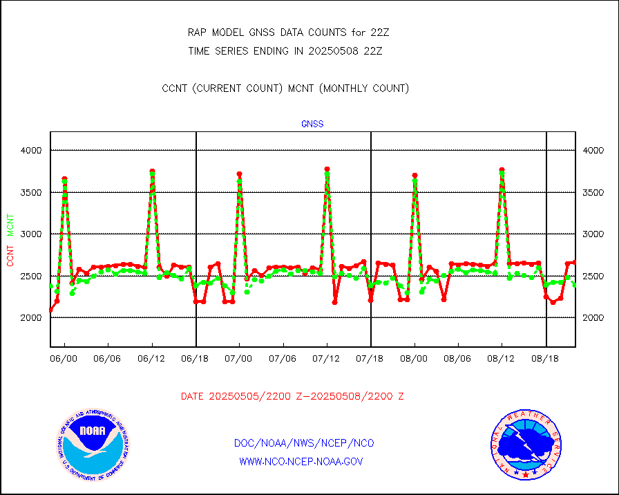
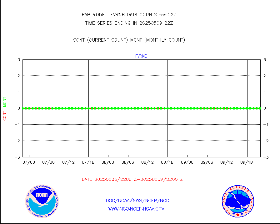
Grnd-based Gbl Navigation Sat System (GNSS) data |
757 |
1953 |
38.8 % |
3020.95-3021.05 |
||||||||||
MODIS (AQUA/TERRA) wvpr imager derived cld motion |
0 |
0 |
n/a |
3019.50-0100.50 |
||||||||||
MODIS (AQUA/TERRA) ir l-wave derived cloud motion |
0 |
0 |
n/a |
3019.50-0100.50 |
||||||||||
GOES/NASA(Langley) hi-res. (1x1 f-o-v) cloud data |
1870196 |
1870857 |
100.0 % |
3021.50-3022.50 |
||||||||||
Buoys decoded from FM-13 format (moored) |
115 |
130 |
88.5 % |
3021.50-3022.50 |
||||||||||
Aviation - METAR |
5772 |
5546 |
104.1 % |
3021.50-3022.50 |
||||||||||
NEXRAD Vel Azm Dsp(VAD) winds via radar coded msg |
0 |
0 |
n/a |
3021.00-3023.00 |
||||||||||
Multi-Agency Profiler (MAP) and SODAR winds |
102 |
95 |
107.4 % |
3020.50-3023.50 |
||||||||||
Rawinsonde - fixed land (from TEMP or PILOT) |
1 |
1 |
100.0 % |
3021.00-3023.00 |
||||||||||
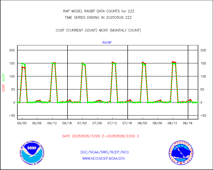
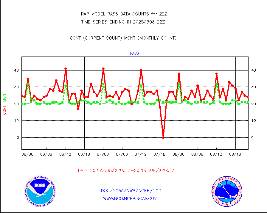
RASS temperatures (NOAA and Multi-Agency) |
21 |
20 |
105.0 % |
3021.50-3022.50 |
||||||||||
Ship - manual and automatic, restricted (BUFR) |
0 |
0 |
n/a |
3021.50-3022.50 |
||||||||||
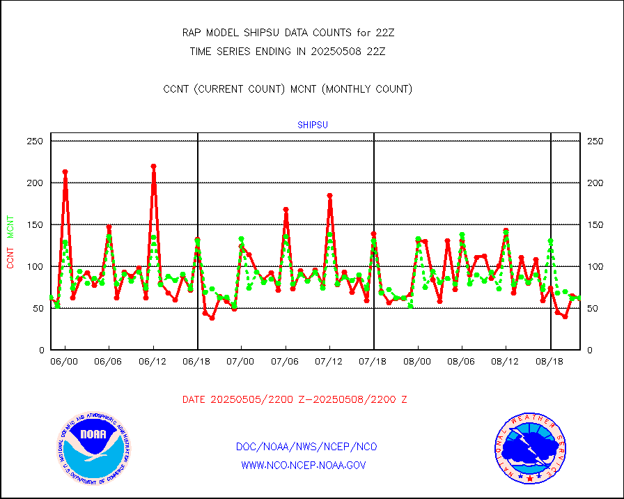
Ship - manual and automatic, unrestricted |
60 |
55 |
109.1 % |
3021.50-3022.50 |
||||||||||
Ship - manual and automatic, unrestricted (BUFR) |
639 |
615 |
103.9 % |
3021.50-3022.50 |
||||||||||
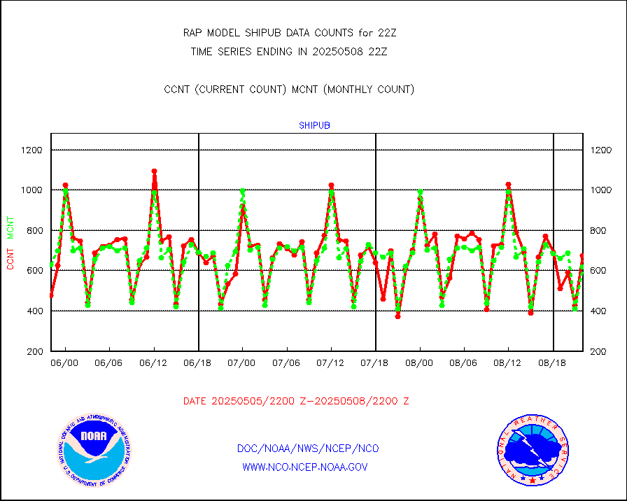
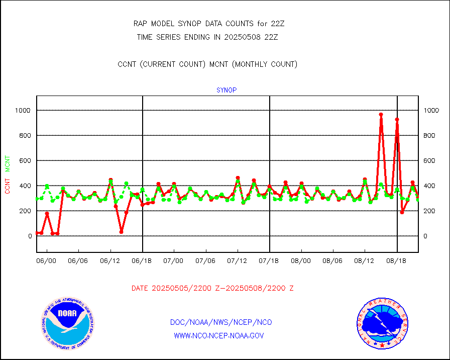
Synoptic - fixed manual and automatic |
275 |
293 |
93.9 % |
3021.50-3022.50 |
||||||||||
Synoptic - fixed manual & auto (decoded fr BUFR) |
2085 |
1984 |
105.1 % |
3021.50-3022.50 |
||||||||||
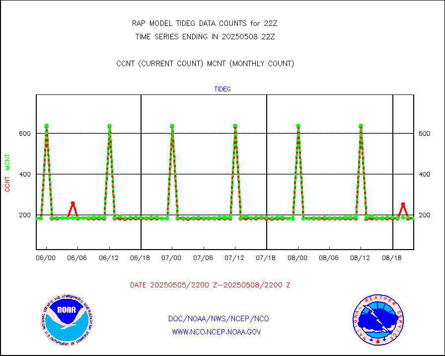
Tide gauge reports decoded from CREX format |
186 |
185 |
100.5 % |
3021.50-3022.50 |
||||||||||
| Data Types of Opportunity with Normal Counts | ||||||||||||||
|---|---|---|---|---|---|---|---|---|---|---|---|---|---|---|
| Type | Description | Hourly Count | Monthly Average | Percent (%) of Monthly Mean | UTC Time Window | |||||||||
GOES-16&up/NESDIS ir short-wv derived cld motion |
197 |
211 |
93.4 % |
3021.00-3021.99 |
||||||||||
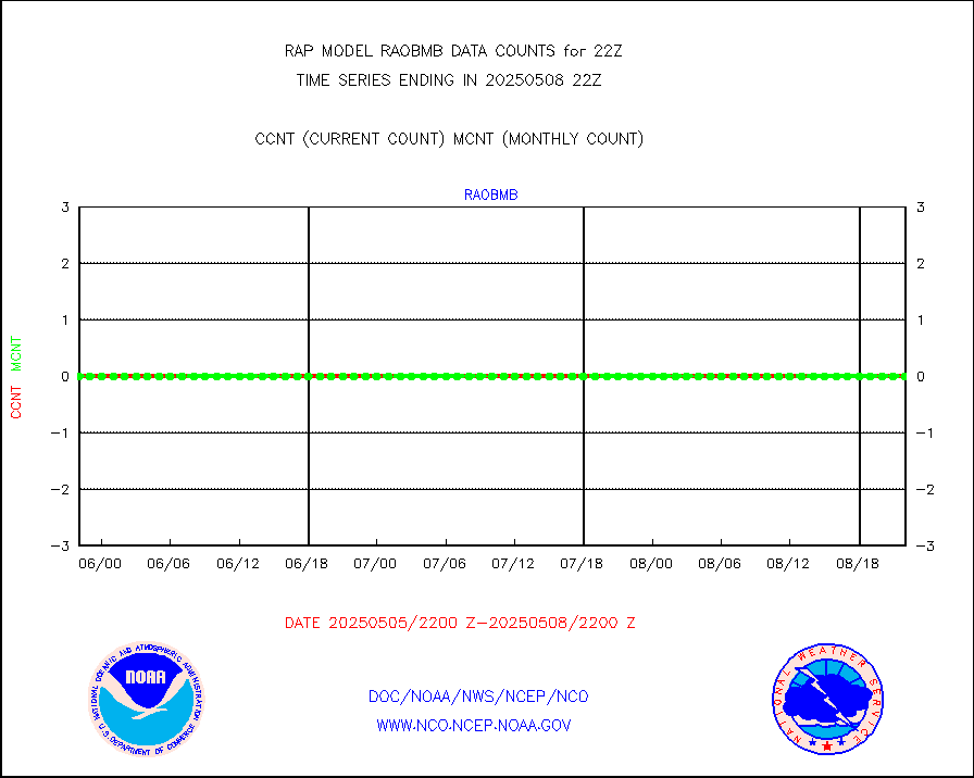
MDCRS ACARS acft data (ARINC via AFWA)(AIREP fmt) |
0 |
0 |
n/a |
3018.75-0101.25 |
||||||||||
Manual AIREP aircraft data (dcded from AIREP fmt) |
1289 |
1118 |
115.3 % |
3018.75-0101.25 |
||||||||||
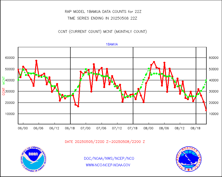
AQUA AIRS/AMSU-A/HSB brightness temps- every FOV |
0 |
0 |
n/a |
3019.00-0100.99 |
||||||||||
AMDAR aircraft data (decoded from AMDAR format) |
775 |
491 |
157.8 % |
3018.75-0101.25 |
||||||||||
AMDAR aircraft data (decoded from BUFR) |
6517 |
6700 |
97.3 % |
3018.75-0101.25 |
||||||||||
GCOM-W AMSR2 1B brightness temperatures |
219278 |
632431 |
34.7 % |
3019.00-3019.99 |
||||||||||
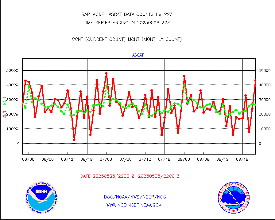
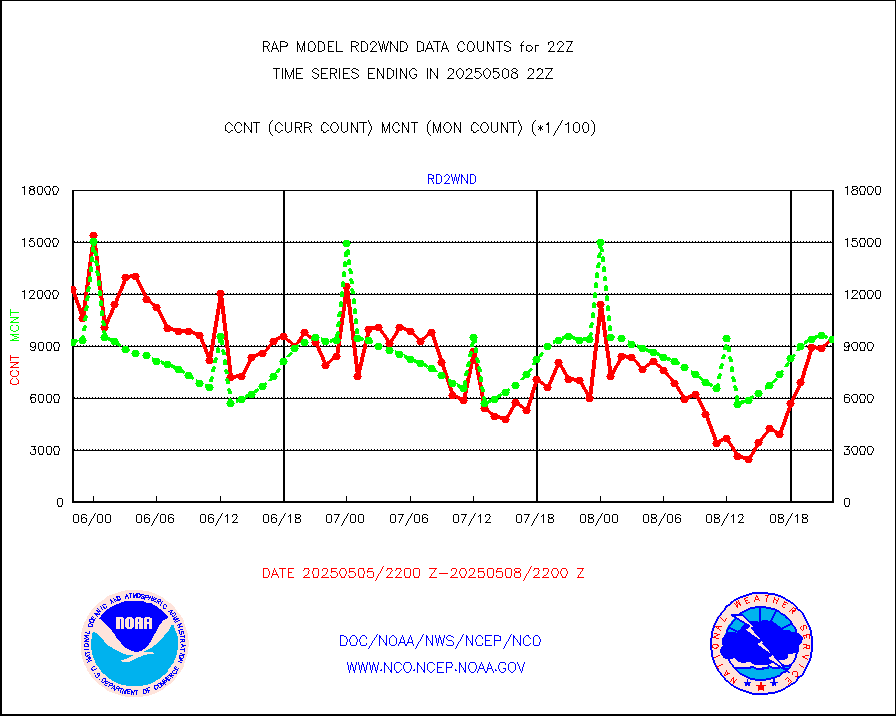
METOP 1-2 ASCAT products |
43112 |
24858 |
173.4 % |
3020.00-0100.00 |
||||||||||
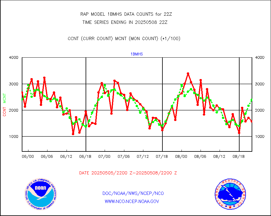
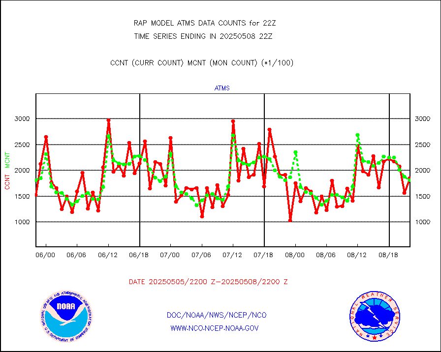
NPP/NOAA-20 ATMS brightness temperatures |
194889 |
167685 |
116.2 % |
3020.00-3023.99 |
||||||||||
NPP/NOAA-20 ATMS bright. temps-direct b-cast SSEC |
156942 |
128184 |
122.4 % |
3020.00-3023.99 |
||||||||||
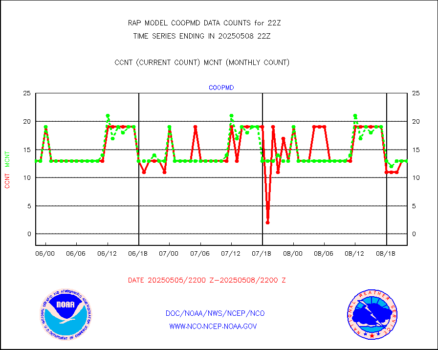
Coop/MADIS NEPP & HCN-Modernization NOAA COOP Obs |
11 |
11 |
100.0 % |
3021.50-3022.50 |
||||||||||
NPP/NOAA-20 CrIS full spctrl radn (431 ch subset) |
104291 |
95068 |
109.7 % |
3020.00-3023.99 |
||||||||||
NPP/NOAA-20 CrIS full spctrl radn dir brdcst SSEC |
45360 |
55675 |
81.5 % |
3020.00-3023.99 |
||||||||||
Coast Guard |
5 |
5 |
100.0 % |
3021.50-3022.50 |
||||||||||
Drifting buoys (decoded from BUFR) |
551 |
511 |
107.8 % |
3021.50-3022.50 |
||||||||||
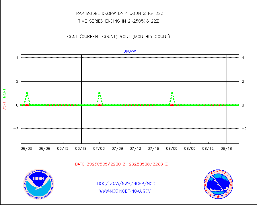
Dropwinsonde (from TEMP DROP) |
0 |
0 |
n/a |
3021.00-3023.00 |
||||||||||
Dropwinsonde (decoded from BUFR) |
0 |
0 |
n/a |
3021.00-3023.00 |
||||||||||
E-AMDAR (European AMDAR acft decoded from BUFR) |
10146 |
10683 |
95.0 % |
3018.75-0101.25 |
||||||||||
NOAA 15-19 & METOP 1-2 AMSU-A proc btmps frm RARS |
3888 |
6270 |
62.0 % |
3021.00-3023.00 |
||||||||||
NOAA 18-19 & METOP 1-2 MHS proc. btemps from RARS |
37101 |
57382 |
64.7 % |
3021.00-3023.00 |
||||||||||
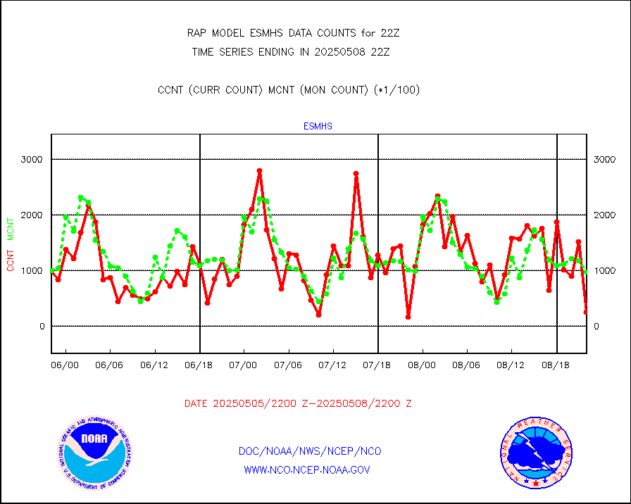
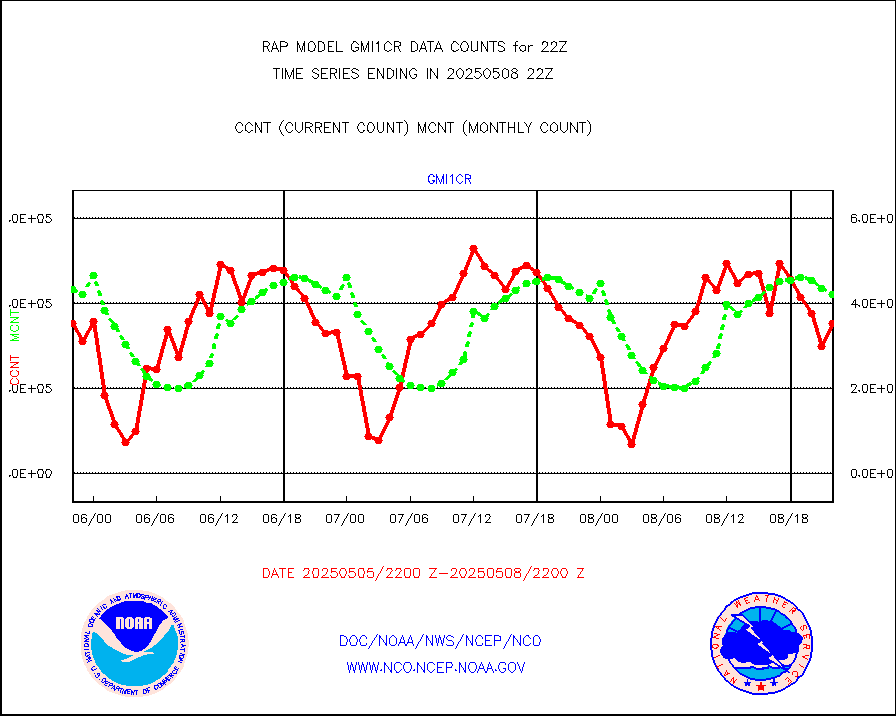
GPM GMI Level 1C-R brightness temperatures |
472015 |
387441 |
121.8 % |
3019.00-0100.99 |
||||||||||
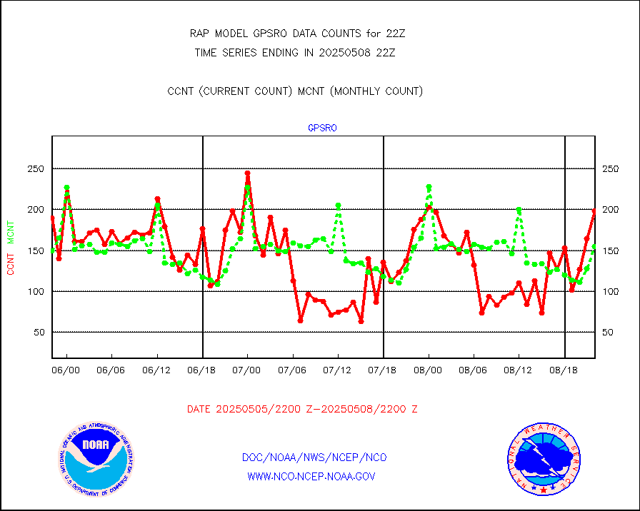
GPS radio occultation data |
167 |
141 |
118.4 % |
3020.00-3023.99 |
||||||||||
GOES-16/17 All Sky Radiances (proc.) |
809306 |
810854 |
99.8 % |
3020.00-3023.99 |
||||||||||
GOES-16/17 Clear Sky Radiances (proc.) |
406904 |
399025 |
102.0 % |
3020.00-3023.99 |
||||||||||
MTSAT/JMA water vapor imager derived cloud motion |
2177 |
3020 |
72.1 % |
3019.50-0100.50 |
||||||||||
GOES-16&up/NESDIS wv imgr/deep-lyr derivd cld mtn |
8298 |
7523 |
110.3 % |
3021.00-3021.99 |
||||||||||
METEOSAT/EUMETSAT wvpr imgr drv cld motion NBseq |
5288 |
5560 |
95.1 % |
3020.50-3023.49 |
||||||||||
GOES-16&up/NESDIS wv imgr/cld-top derived cld mtn |
17010 |
16309 |
104.3 % |
3021.00-3021.99 |
||||||||||
METOP 1-2 IASI 1C radiances-direct broadcast SSEC |
34905 |
46694 |
74.8 % |
3020.00-3023.99 |
||||||||||
METEOSAT/EUMETSAT ir lg-wave drv cld motion NBseq |
3033 |
3168 |
95.7 % |
3020.50-3023.49 |
||||||||||
VIIRS (NPP/NOAA-20) ir lg-wv drv cloud motion(NB) |
0 |
0 |
n/a |
3019.50-0100.50 |
||||||||||
AVHRR (NOAA/METOP) ir lg-wave derived cld motion |
0 |
0 |
n/a |
3019.50-0100.50 |
||||||||||
AVHRR (METOP) ir lg-wave derived cld motion |
0 |
0 |
n/a |
3020.50-3023.49 |
||||||||||
MTSAT/JMA infrared long-wave derived cloud motion |
2159 |
2416 |
89.4 % |
3019.50-0100.50 |
||||||||||
GOES-16&up/NESDIS ir long-wave derived cld motion |
31824 |
31867 |
99.9 % |
3021.00-3021.99 |
||||||||||
Korean AMDAR aircraft data (decoded from BUFR) |
30 |
15 |
200.0 % |
3018.75-0101.25 |
||||||||||
Land-based CMAN stations decoded from CMAN format |
37 |
39 |
94.9 % |
3021.50-3022.50 |
||||||||||
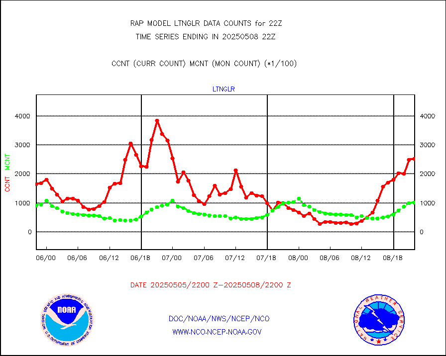
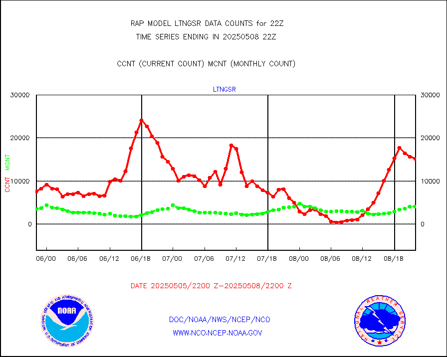
LLDN Long-rng lightning from Vaisala via NOAAPORT |
327940 |
257156 |
127.5 % |
3021.00-3022.50 |
||||||||||
NLDN Shrt-rng lightning from Vaisala via NOAAPORT |
20386 |
14619 |
139.4 % |
3021.00-3022.50 |
||||||||||
Moored buoys (decoded from BUFR) |
681 |
587 |
116.0 % |
3021.50-3022.50 |
||||||||||
Mesonet/MADIS Colorado E-470 (Interstate 470) |
16 |
23 |
69.6 % |
3021.50-3022.50 |
||||||||||
Mesonet/MADIS Alaska Department of Transportation |
119 |
76 |
156.6 % |
3021.50-3022.50 |
||||||||||
Mesonet/MADIS U.S. Army Aberdeen Proving Grounds |
0 |
0 |
n/a |
3021.50-3022.50 |
||||||||||
Mesonet/MADIS Citizen Weather Observers Program |
58017 |
54885 |
105.7 % |
3021.50-3022.50 |
||||||||||
Mesonet/MADIS "Anything Weather" |
0 |
0 |
n/a |
3021.50-3022.50 |
||||||||||
Mesonet/MADIS Colorado Dept. of Transportation |
0 |
0 |
n/a |
3021.50-3022.50 |
||||||||||
Mesonet/MADIS DC Net |
0 |
0 |
n/a |
3021.50-3022.50 |
||||||||||
Mesonet/MADIS Denver Urban Drainage & Flood Cntrl |
0 |
0 |
n/a |
3021.50-3022.50 |
||||||||||
Mesonet/MADIS Florida (FAWN & USF) |
3 |
3 |
100.0 % |
3021.50-3022.50 |
||||||||||
Mesonet/MADIS Florida Dept. of Transportation |
0 |
0 |
n/a |
3021.50-3022.50 |
||||||||||
Mesonet/MADIS Georgia Dept. of Transportation |
0 |
0 |
n/a |
3021.50-3022.50 |
||||||||||
Mesonet/MADIS NWS Hydromet Auto Data System(HADS) |
4301 |
4624 |
93.0 % |
3021.50-3022.50 |
||||||||||
Mesonet/MADIS Iowa Environmental |
133 |
156 |
85.3 % |
3021.50-3022.50 |
||||||||||
Mesonet/MADIS Indiana Dept. of Transportation |
0 |
0 |
n/a |
3021.50-3022.50 |
||||||||||
Mesonet/MADIS Iowa Department of Transportation |
0 |
0 |
n/a |
3021.50-3022.50 |
||||||||||
Mesonet/MADIS Kansas Department of Transportation |
260 |
317 |
82.0 % |
3021.50-3022.50 |
||||||||||
Mesonet/MADIS Oklahoma Mesonet |
420 |
535 |
78.5 % |
3021.50-3022.50 |
||||||||||
Mesonet/MADIS Louisiana State/Jackson State Univ. |
0 |
0 |
n/a |
3021.50-3022.50 |
||||||||||
Mesonet/MADIS Missouri Commercial Agricult Wx Net |
241 |
282 |
85.5 % |
3021.50-3022.50 |
||||||||||
Mesonet/MADIS Minnesota Dept. of Transportation |
0 |
0 |
n/a |
3021.50-3022.50 |
||||||||||
Mesonet/MADIS NOS-Phys Oceanographic Realtime Sys |
246 |
255 |
96.5 % |
3021.50-3022.50 |
||||||||||
Mesonet/MADIS NFIC Remote Automated Wx Stns(RAWS) |
1306 |
1317 |
99.2 % |
3021.50-3022.50 |
||||||||||
Mesonet/MADIS many providers, not separated out |
38622 |
37379 |
103.3 % |
3021.50-3022.50 |
||||||||||
Mesonet/MADIS UrbaNet |
2886 |
3019 |
95.6 % |
3021.50-3022.50 |
||||||||||
Mesonet/MADIS Virginia Dept. of Transportation |
0 |
0 |
n/a |
3021.50-3022.50 |
||||||||||
Mesonet/MADIS "Weather for You" |
0 |
0 |
n/a |
3021.50-3022.50 |
||||||||||
Mesonet/MADIS Wisconsin Dept. of Transportation |
0 |
0 |
n/a |
3021.50-3022.50 |
||||||||||
Mesonet/MADIS MesoWest (many subproviders) |
36425 |
34550 |
105.4 % |
3021.50-3022.50 |
||||||||||
Mesonet/MADIS West Texas |
4428 |
5057 |
87.6 % |
3021.50-3022.50 |
||||||||||
METOP 1-2 IASI 1C radiance data (varbl. channels) |
15909 |
29700 |
53.6 % |
3020.00-3023.99 |
||||||||||
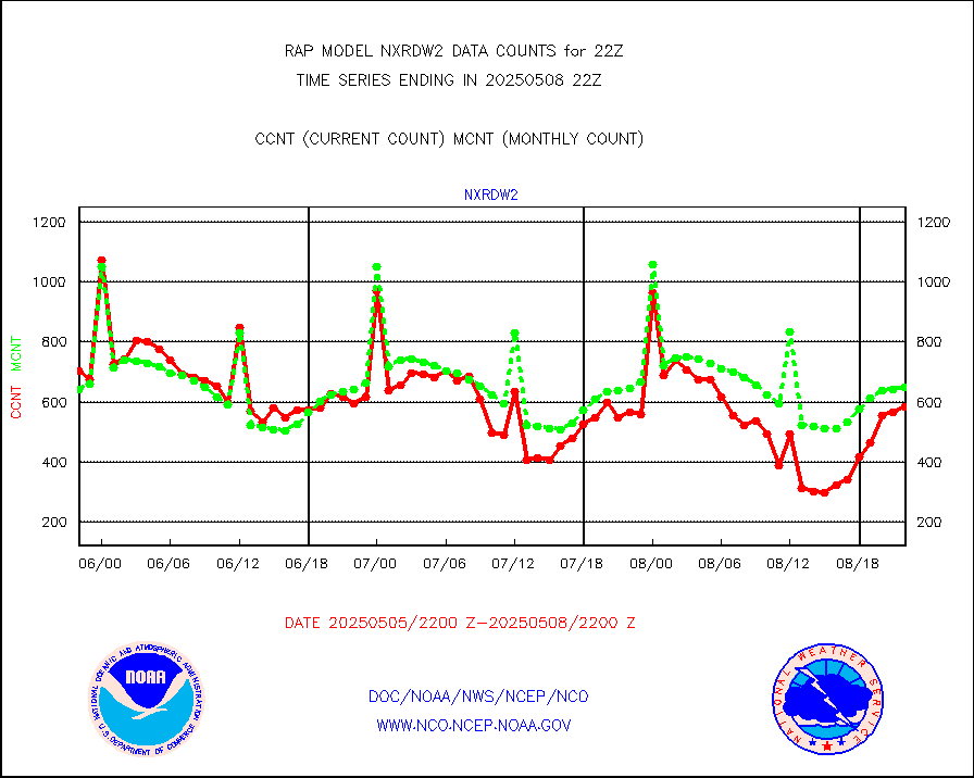
NEXRAD Vel Azm Dsp(VAD) winds via Level 2 decoder |
796 |
764 |
104.2 % |
3021.00-3023.00 |
||||||||||
NOAA 16-19 Solar Backscatter UV-2 rad frm V8 BUFR |
0 |
0 |
n/a |
3020.00-3022.99 |
||||||||||
PIBAL (from PILOT, PILOT SHIP, PILOT MOBIL) |
0 |
0 |
n/a |
3021.00-3023.00 |
||||||||||
PIBAL (decoded from BUFR) |
0 |
0 |
n/a |
3021.00-3023.00 |
||||||||||
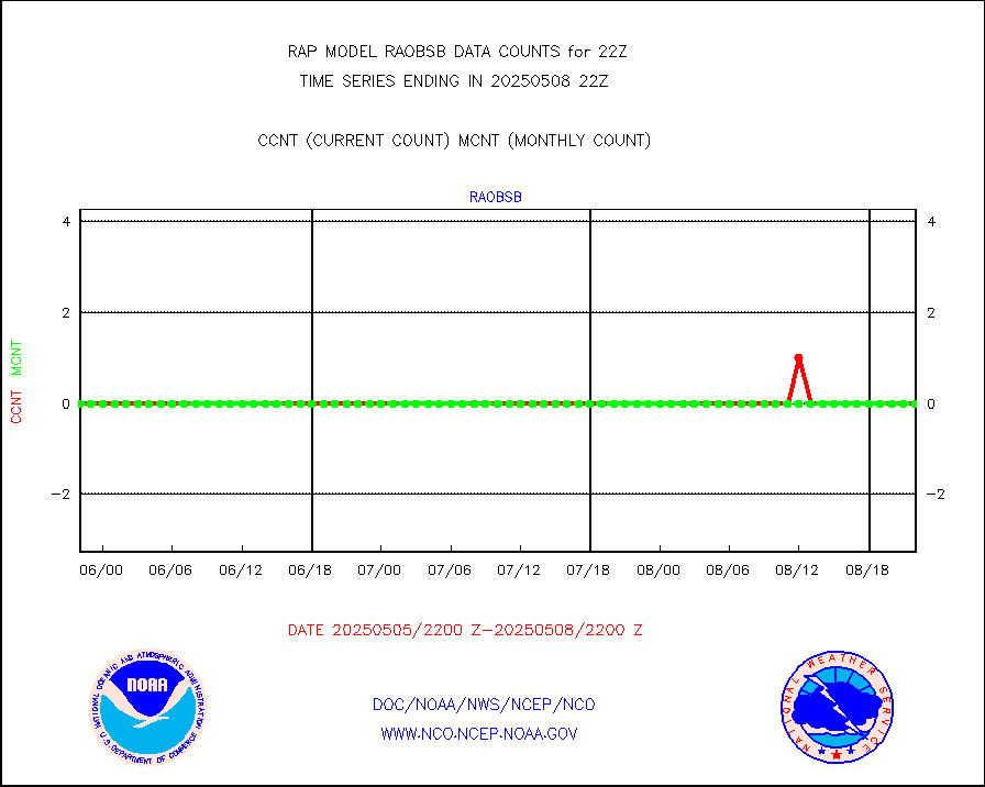
Manual PIREP aircraft data (dcded from AIREP fmt) |
545 |
499 |
109.2 % |
3018.75-0101.25 |
||||||||||
Profilr winds from PIBAL (PILOT,PILOT SHIP/MOBIL) |
0 |
0 |
n/a |
3020.50-3023.50 |
||||||||||
Rawinsonde - fixed land (decoded from BUFR) |
0 |
0 |
n/a |
3021.00-3023.00 |
||||||||||
Rawinsonde - mobile land (from TEMP/PILOT MOBIL) |
0 |
0 |
n/a |
3021.00-3023.00 |
||||||||||
Rawinsonde - mobile land (decoded from BUFR) |
0 |
0 |
n/a |
3021.00-3023.00 |
||||||||||
Rawinsonde - ship (from TEMP SHIP, PILOT SHIP) |
0 |
0 |
n/a |
3021.00-3023.00 |
||||||||||
Rawinsonde - ship (decoded from BUFR) |
0 |
0 |
n/a |
3021.00-3023.00 |
||||||||||
NEXRAD radial wind (Level 2 - GTS) |
1632622 |
1241574 |
131.5 % |
3021.50-3022.49 |
||||||||||
Flight level reconnaissance aircraft data |
0 |
0 |
n/a |
3021.00-3023.00 |
||||||||||
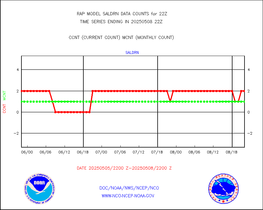
Surface Marine Saildrone (decoded from BUFR) |
2 |
2 |
100.0 % |
3020.00-3023.99 |
||||||||||
Megha-Tropiques SAPHIR L1A2 brightness temps |
0 |
0 |
n/a |
3019.00-0100.99 |
||||||||||
METEOSAT-10 2nd Gen SEVIRI All Sky Radiance(proc) |
9512 |
9492 |
100.2 % |
3020.00-3023.99 |
||||||||||
METEOSAT-10 2nd Gen SEVIRI Clr Sky Radiance(proc) |
0 |
0 |
n/a |
3020.00-3023.99 |
||||||||||
Ship - manual and automatic, restricted |
0 |
5 |
0.0 % |
3021.50-3022.50 |
||||||||||
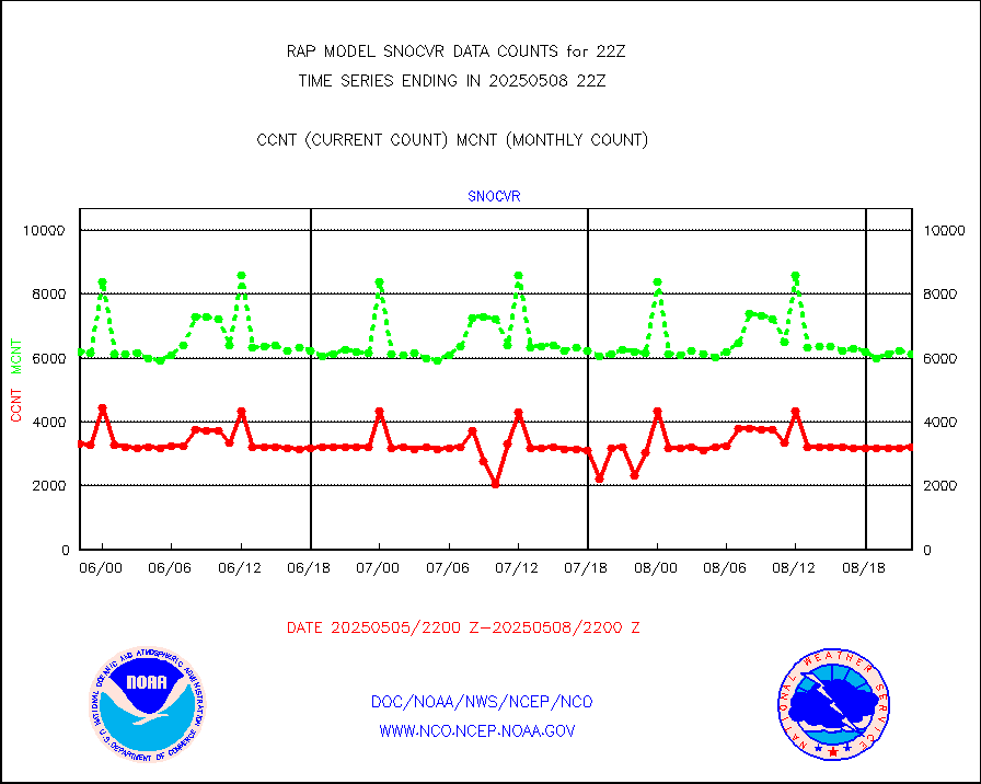
NOW COVER, DEPTH/DENSITY AND WATER EQUIVALENT |
3209 |
6015 |
53.3 % |
3020.00-0100.00 |
||||||||||
Sub-surface float and glider profile (BUFR) |
0 |
1 |
0.0 % |
3020.00-3023.99 |
||||||||||
Synoptic - restricted (WMO Res 40) manual & auto. |
0 |
0 |
n/a |
3021.50-3022.50 |
||||||||||
Synoptic - restricted (WMO Res 40)(decoded BUFR) |
347 |
357 |
97.2 % |
3021.50-3022.50 |
||||||||||
Synoptic - mobile manual & auto (decoded fr BUFR) |
0 |
0 |
n/a |
3021.50-3022.50 |
||||||||||
TAMDAR aircft data-all types(from Panasonic,BUFR) |
133 |
163 |
81.6 % |
3018.75-0101.25 |
||||||||||
MTSAT/JMA visible derived cloud motion |
1532 |
1473 |
104.0 % |
3019.50-0100.50 |
||||||||||
GOES-16&up/NESDIS visible derived cloud motion |
185539 |
177699 |
104.4 % |
3021.00-3021.99 |
||||||||||
METEOSAT/EUMETSAT visible drv cld motion NBseq |
2423 |
1386 |
174.8 % |
3020.50-3023.49 |
||||||||||


