| Suspect Data Shortages in Critical Types - Monitor | ||||||||||||||
|---|---|---|---|---|---|---|---|---|---|---|---|---|---|---|
| Type | Description | Hourly Count | Monthly Average | Percent (%) of Monthly Mean | UTC Time Window | |||||||||
NOAA 18-19 & METOP 1-2 HIRS-4 NCEP-proc. br.temps |
0 |
12107 |
0.0 % |
0120.00-0120.99 |
||||||||||
NOAA 15-19 & METOP 1-2 HIRS-3/4 pr btmps frm RARS |
0 |
9602 |
0.0 % |
0121.50-0122.49 |
||||||||||
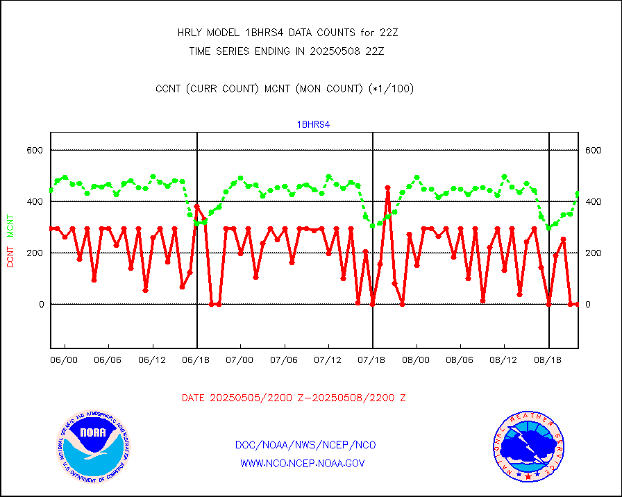
Grnd-based Gbl Navigation Sat System (GNSS) data |
1321 |
6465 |
20.4 % |
0121.00-0121.99 |
||||||||||
Mesonet/MADIS Citizen Weather Observers Program |
15891 |
58666 |
27.1 % |
0121.50-0122.49 |
||||||||||
Mesonet/MADIS AWS Convergence Technologies, Inc. |
2202 |
19835 |
11.1 % |
0121.50-0122.49 |
||||||||||
Mesonet/MADIS many providers, not separated out |
14484 |
71265 |
20.3 % |
0121.00-0122.49 |
||||||||||
Mesonet/MADIS MesoWest (many subproviders) |
7843 |
34731 |
22.6 % |
0121.50-0122.49 |
||||||||||
| Shortage in Data Type of Opportunity - Monitor | ||||||||||||||
|---|---|---|---|---|---|---|---|---|---|---|---|---|---|---|
| Type | Description | Hourly Count | Monthly Average | Percent (%) of Monthly Mean | UTC Time Window | |||||||||
P.M.(N18-19) AVHRR GAC NCEP-proc clr & sea btemps |
0 |
442124 |
0.0 % |
0119.50-0120.49 |
||||||||||
METOP 1-2 IASI 1C radiance data vbl chn from RARS |
0 |
3563 |
0.0 % |
0121.00-0121.99 |
||||||||||
INDIA SATWIND, INSAT WV channel |
0 |
802 |
0.0 % |
0121.00-0121.99 |
||||||||||
High Density OBs from reconnaissance acft data |
0 |
30 |
0.0 % |
0121.50-0122.49 |
||||||||||
INDIA SATWIND, INSAT IR channel |
0 |
1268 |
0.0 % |
0121.00-0121.99 |
||||||||||
NPP/NOAA-20 VIIRS SST - CLEAR & OVER WATER |
0 |
1337741 |
0.0 % |
0121.50-0122.49 |
||||||||||
NPP/NOAA-20 VIIRS SST - PROBABLY CLR & OVER WATER |
0 |
356998 |
0.0 % |
0121.50-0122.49 |
||||||||||
| Critical Data with Normal Counts | ||||||||||||||
|---|---|---|---|---|---|---|---|---|---|---|---|---|---|---|
| Type | Description | Hourly Count | Monthly Average | Percent (%) of Monthly Mean | UTC Time Window | |||||||||
NOAA 15-19 & METOP 1-2 AMSU-A NCEP-proc. br.temps |
26735 |
33675 |
79.4 % |
0120.00-0120.99 |
||||||||||
NOAA 18-19 & METOP 1-2 MHS NCEP-proces. br. temps |
236888 |
250239 |
94.7 % |
0120.00-0120.99 |
||||||||||
MDCRS ACARS acft data from ARINC(dcded from BUFR) |
24874 |
31071 |
80.1 % |
0121.50-0122.49 |
||||||||||
Manual AIREP aircraft data (dcded from AIREP fmt) |
213 |
230 |
92.6 % |
0121.50-0122.49 |
||||||||||
AQUA AIRS/AMSU-A/HSB brightness temps- every FOV |
0 |
0 |
n/a |
0119.50-0120.49 |
||||||||||
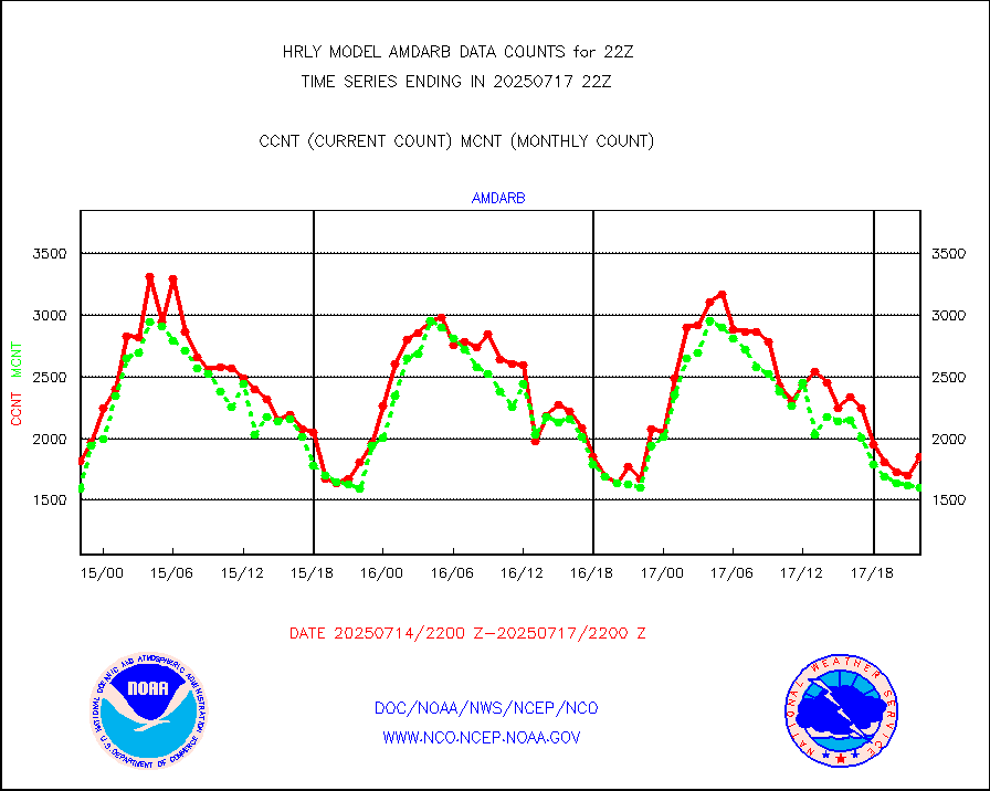
AMDAR aircraft data (decoded from AMDAR format) |
131 |
117 |
112.0 % |
0121.50-0122.49 |
||||||||||
AMDAR aircraft data (decoded from BUFR) |
1414 |
1584 |
89.3 % |
0121.50-0122.49 |
||||||||||
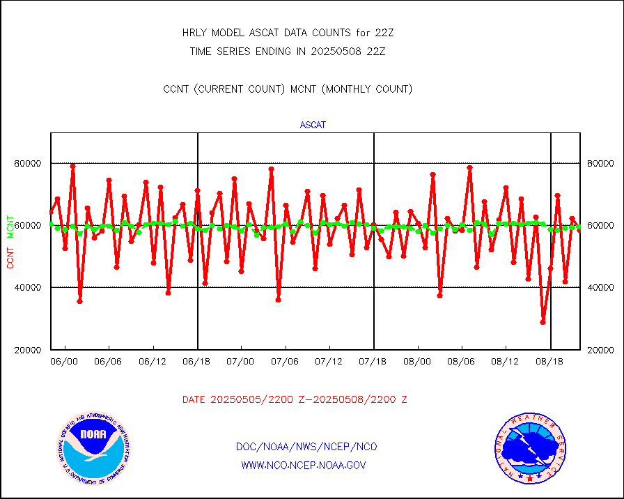
METOP 1-2 ASCAT products |
76776 |
58741 |
130.7 % |
0120.50-0121.49 |
||||||||||
NPP/NOAA-20 ATMS brightness temperatures |
377280 |
343411 |
109.9 % |
0120.50-0121.49 |
||||||||||
Canadian AMDAR aircraft data (decoded from BUFR) |
0 |
0 |
n/a |
0121.50-0122.49 |
||||||||||
Surface Marine CMAN rpts decoded from BUFR format |
1871 |
1852 |
101.0 % |
0121.50-0122.50 |
||||||||||
Buoys decoded from FM-18 fmt (moored or drifting) |
7 |
11 |
63.6 % |
0121.50-0122.49 |
||||||||||
E-AMDAR (European AMDAR acft decoded from BUFR) |
1706 |
1645 |
103.7 % |
0121.50-0122.49 |
||||||||||
NOAA 15-19 & METOP 1-2 AMSU-A proc btmps frm RARS |
8241 |
16600 |
49.6 % |
0121.50-0122.49 |
||||||||||
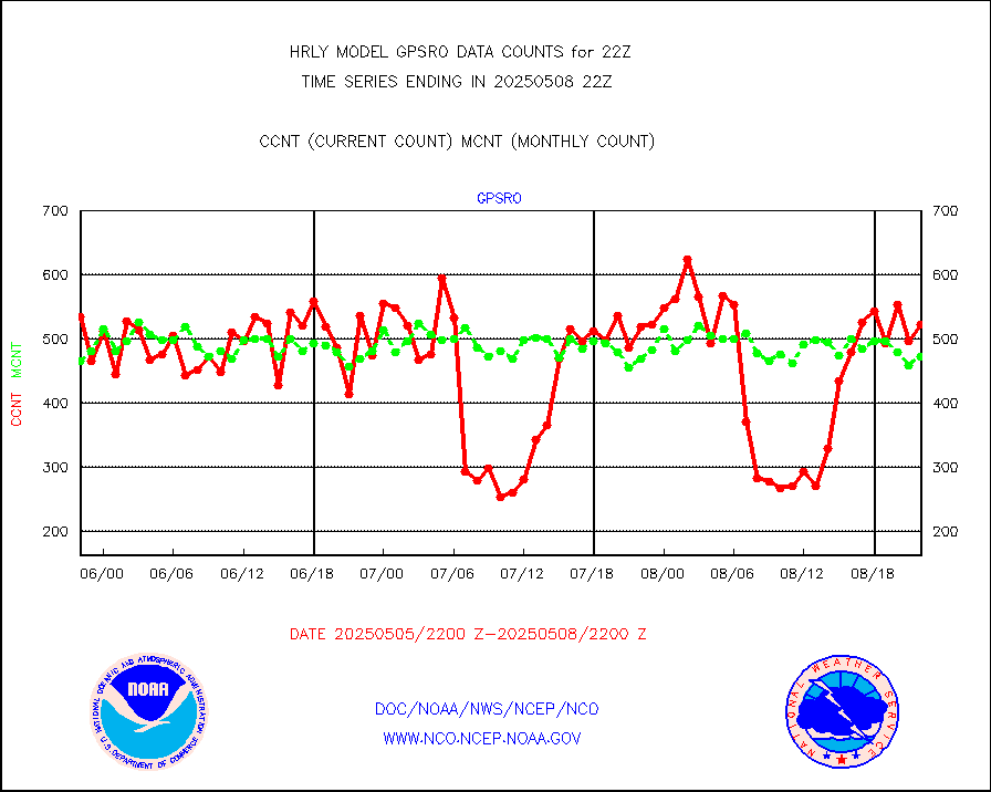
GPS radio occultation data |
525 |
483 |
108.7 % |
0119.50-0120.49 |
||||||||||
GOES-16/17 All Sky Radiances (proc.) |
720952 |
719209 |
100.2 % |
0121.50-0122.49 |
||||||||||
GOES-16/17 Clear Sky Radiances (proc.) |
375483 |
378319 |
99.3 % |
0121.50-0122.49 |
||||||||||
MTSAT/JMA water vapor imager derived cloud motion |
20624 |
18881 |
109.2 % |
0119.50-0120.49 |
||||||||||
MODIS (AQUA/TERRA) wvpr imager derived cld motion |
0 |
0 |
n/a |
0118.00-0118.99 |
||||||||||
GOES-16&up/NESDIS wv imgr/cld-top derived cld mtn |
27323 |
29615 |
92.3 % |
0121.00-0121.99 |
||||||||||
METEOSAT/EUMETSAT ir lg-wave drv cld motion NBseq |
11365 |
20789 |
54.7 % |
0120.50-0121.49 |
||||||||||
MTSAT/JMA infrared long-wave derived cloud motion |
16142 |
15573 |
103.7 % |
0119.50-0120.49 |
||||||||||
MODIS (AQUA/TERRA) ir l-wave derived cloud motion |
0 |
0 |
n/a |
0118.00-0118.99 |
||||||||||
GOES-16&up/NESDIS ir long-wave derived cld motion |
82843 |
82220 |
100.8 % |
0121.00-0121.99 |
||||||||||
GOES/NASA(Langley) hi-res. (1x1 f-o-v) cloud data |
6441999 |
6289094 |
102.4 % |
0121.50-0122.49 |
||||||||||
Buoys decoded from FM-13 format (moored) |
123 |
122 |
100.8 % |
0121.50-0122.49 |
||||||||||
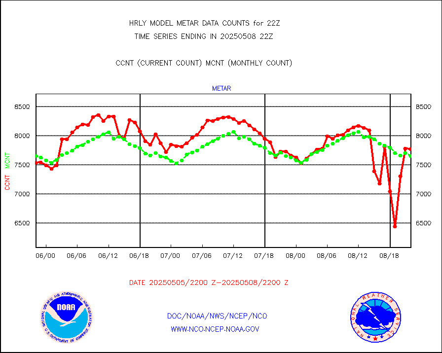
Aviation - METAR |
7847 |
7716 |
101.7 % |
0121.50-0122.49 |
||||||||||
Mesonet/MADIS Colorado E-470 (Interstate 470) |
24 |
23 |
104.3 % |
0121.50-0122.49 |
||||||||||
Mesonet/MADIS Alaska Department of Transportation |
59 |
89 |
66.3 % |
0121.50-0122.49 |
||||||||||
Mesonet/MADIS U.S. Army Aberdeen Proving Grounds |
0 |
0 |
n/a |
0121.50-0122.49 |
||||||||||
Mesonet/MADIS "Anything Weather" |
0 |
0 |
n/a |
0121.50-0122.49 |
||||||||||
Mesonet/MADIS Colorado Dept. of Transportation |
0 |
0 |
n/a |
0121.50-0122.49 |
||||||||||
Mesonet/MADIS DC Net |
0 |
0 |
n/a |
0121.50-0122.49 |
||||||||||
Mesonet/MADIS Denver Urban Drainage & Flood Cntrl |
0 |
0 |
n/a |
0121.50-0122.49 |
||||||||||
Mesonet/MADIS Florida (FAWN & USF) |
3 |
4 |
75.0 % |
0121.50-0122.49 |
||||||||||
Mesonet/MADIS Florida Dept. of Transportation |
0 |
0 |
n/a |
0121.50-0122.49 |
||||||||||
Mesonet/MADIS Georgia Dept. of Transportation |
0 |
0 |
n/a |
0121.50-0122.49 |
||||||||||
Mesonet/MADIS NWS Hydromet Auto Data System(HADS) |
4441 |
6146 |
72.3 % |
0121.50-0122.49 |
||||||||||
Mesonet/MADIS Iowa Environmental |
156 |
183 |
85.2 % |
0121.50-0122.49 |
||||||||||
Mesonet/MADIS Indiana Dept. of Transportation |
0 |
0 |
n/a |
0121.50-0122.49 |
||||||||||
Mesonet/MADIS Iowa Department of Transportation |
0 |
0 |
n/a |
0121.50-0122.49 |
||||||||||
Mesonet/MADIS Kansas Department of Transportation |
300 |
363 |
82.6 % |
0121.50-0122.49 |
||||||||||
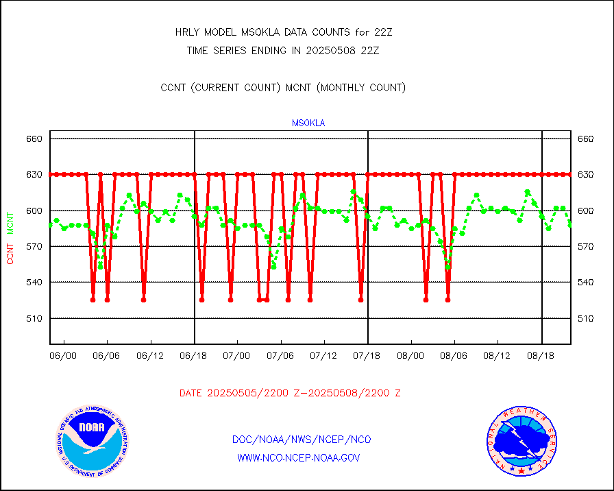
Mesonet/MADIS Oklahoma Mesonet |
525 |
595 |
88.2 % |
0121.50-0122.49 |
||||||||||
Mesonet/MADIS Louisiana State/Jackson State Univ. |
0 |
0 |
n/a |
0121.50-0122.49 |
||||||||||
Mesonet/MADIS Missouri Commercial Agricult Wx Net |
264 |
331 |
79.8 % |
0121.50-0122.49 |
||||||||||
Mesonet/MADIS Minnesota Dept. of Transportation |
0 |
0 |
n/a |
0121.50-0122.49 |
||||||||||
Mesonet/MADIS NOS-Phys Oceanographic Realtime Sys |
240 |
374 |
64.2 % |
0121.50-0122.49 |
||||||||||
Mesonet/MADIS NFIC Remote Automated Wx Stns(RAWS) |
1371 |
1875 |
73.1 % |
0121.50-0122.49 |
||||||||||
Mesonet/MADIS Virginia Dept. of Transportation |
0 |
0 |
n/a |
0121.50-0122.49 |
||||||||||
Mesonet/MADIS "Weather for You" |
0 |
0 |
n/a |
0121.50-0122.49 |
||||||||||
Mesonet/MADIS Wisconsin Dept. of Transportation |
0 |
0 |
n/a |
0121.50-0122.49 |
||||||||||
Mesonet/MADIS West Texas |
5043 |
5991 |
84.2 % |
0121.50-0122.49 |
||||||||||
METOP 1-2 IASI 1C radiance data (varbl. channels) |
106920 |
87448 |
122.3 % |
0120.00-0120.99 |
||||||||||
NEXRAD Vel Azm Dsp(VAD) winds via radar coded msg |
0 |
0 |
n/a |
0121.50-0122.49 |
||||||||||
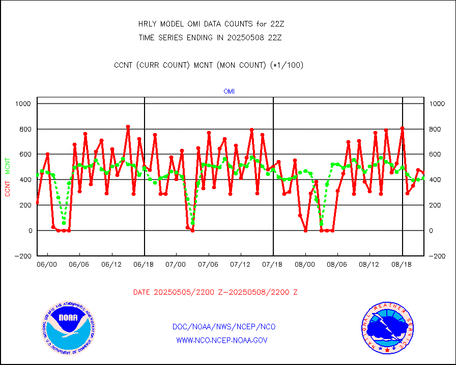
Aura Ozone Monitoring Instrument (OMI) data |
0 |
0 |
n/a |
0119.50-0120.49 |
||||||||||
NOAA 16-19 Solar Backscatter UV-2 rad frm V8 BUFR |
0 |
0 |
n/a |
0120.00-0120.99 |
||||||||||
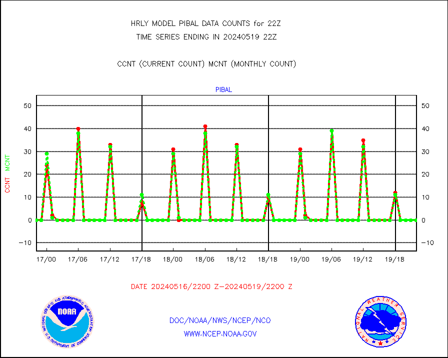
PIBAL (from PILOT, PILOT SHIP, PILOT MOBIL) |
0 |
0 |
n/a |
0121.50-0122.49 |
||||||||||
Multi-Agency Profiler (MAP) and SODAR winds |
45 |
46 |
97.8 % |
0121.50-0122.49 |
||||||||||
Rawinsonde - fixed land (from TEMP or PILOT) |
0 |
0 |
n/a |
0121.50-0122.49 |
||||||||||
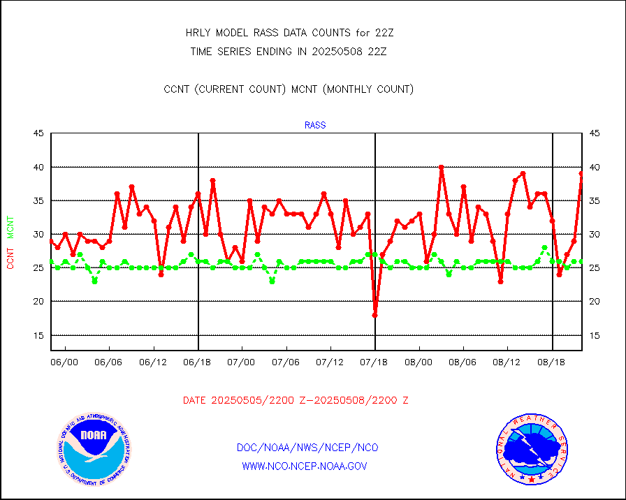
RASS temperatures (NOAA and Multi-Agency) |
20 |
22 |
90.9 % |
0121.50-0122.49 |
||||||||||
NEXRAD reflectivity (Lvl 2 - GTS) |
4562894 |
4699596 |
97.1 % |
0121.50-0122.49 |
||||||||||
NEXRAD radial wind (Level 2 - GTS) |
2307542 |
1738780 |
132.7 % |
0121.50-0122.49 |
||||||||||
METEOSAT-10 2nd Gen SEVIRI Clr Sky Radiance(proc) |
0 |
0 |
n/a |
0121.50-0122.49 |
||||||||||
Ship - manual and automatic, restricted (BUFR) |
0 |
0 |
n/a |
0121.50-0122.50 |
||||||||||
Ship - manual and automatic, unrestricted |
154 |
143 |
107.7 % |
0121.50-0122.50 |
||||||||||
Ship - manual and automatic, unrestricted (BUFR) |
955 |
864 |
110.5 % |
0121.50-0122.50 |
||||||||||
Synoptic - fixed manual and automatic |
618 |
715 |
86.4 % |
0121.50-0122.49 |
||||||||||
Synoptic - fixed manual & auto (decoded fr BUFR) |
5256 |
5219 |
100.7 % |
0121.50-0122.49 |
||||||||||
Synoptic - restricted (WMO Res 40) manual & auto. |
0 |
0 |
n/a |
0121.50-0122.49 |
||||||||||
Synoptic - restricted (WMO Res 40)(decoded BUFR) |
338 |
408 |
82.8 % |
0121.50-0122.49 |
||||||||||
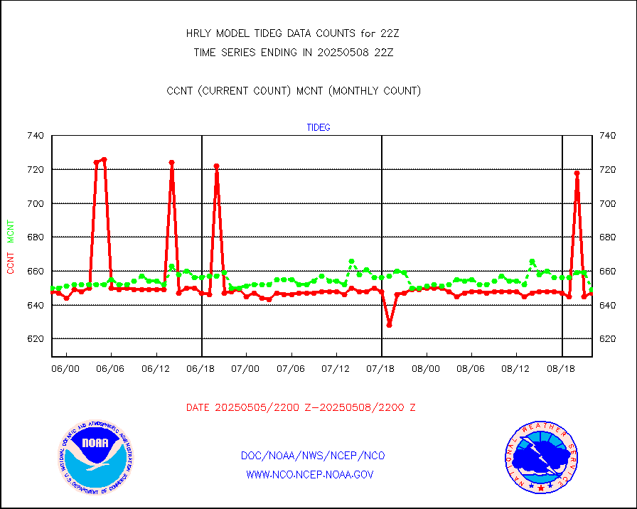
Tide gauge reports decoded from CREX format |
659 |
656 |
100.5 % |
0121.00-0121.99 |
||||||||||
| Data Types of Opportunity with Normal Counts | ||||||||||||||
|---|---|---|---|---|---|---|---|---|---|---|---|---|---|---|
| Type | Description | Hourly Count | Monthly Average | Percent (%) of Monthly Mean | UTC Time Window | |||||||||
GOES-16&up/NESDIS ir short-wv derived cld motion |
5872 |
4916 |
119.4 % |
0121.00-0121.99 |
||||||||||
MDCRS ACARS acft data (ARINC via AFWA)(AIREP fmt) |
0 |
0 |
n/a |
0121.50-0122.49 |
||||||||||
Himawari Clear Sky Radiance |
0 |
0 |
n/a |
0121.00-0121.99 |
||||||||||
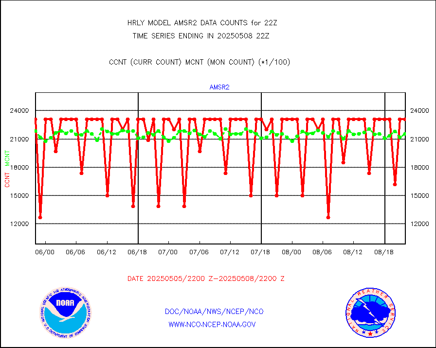
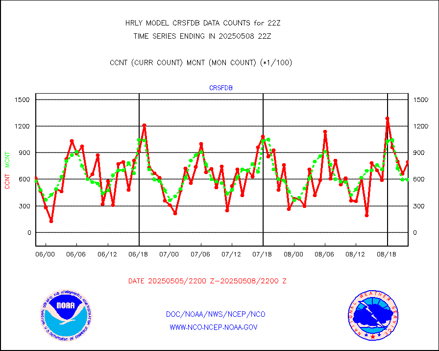
GCOM-W AMSR2 1B brightness temperatures |
2309472 |
2158488 |
107.0 % |
0120.00-0120.99 |
||||||||||
NPP/NOAA-20 ATMS bright. temps-direct b-cast SSEC |
169683 |
132017 |
128.5 % |
0120.50-0121.49 |
||||||||||
POES/NESDIS - processed ATOVS soundings/radiances |
0 |
0 |
n/a |
0120.00-0120.99 |
||||||||||
A.M.(N17,M2,M3) AVHRR GAC NCEP-proc clr&sea btmps |
1677107 |
1190696 |
140.9 % |
0119.50-0120.49 |
||||||||||
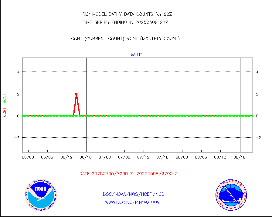
eXpendable BathyThermograph, mooring (BATHY fmt) |
0 |
0 |
n/a |
0115.00-0115.99 |
||||||||||
Coop/MADIS NEPP & HCN-Modernization NOAA COOP Obs |
11 |
11 |
100.0 % |
0121.50-0122.49 |
||||||||||
NPP/NOAA-20 CrIS full spctrl radn (431 ch subset) |
204210 |
219191 |
93.2 % |
0120.50-0121.49 |
||||||||||
NPP/NOAA-20 CrIS full spctrl radn dir brdcst SSEC |
45954 |
48190 |
95.4 % |
0120.50-0121.49 |
||||||||||
Coast Guard |
5 |
5 |
100.0 % |
0121.50-0122.50 |
||||||||||
Drifting buoys (decoded from BUFR) |
1446 |
1452 |
99.6 % |
0121.50-0122.50 |
||||||||||
Dropwinsonde (from TEMP DROP) |
0 |
0 |
n/a |
0121.50-0122.49 |
||||||||||
Dropwinsonde (decoded from BUFR) |
0 |
0 |
n/a |
0121.51-0122.49 |
||||||||||
GOES imager effective cloud amount data (U.Wisc.) |
8535568 |
8014199 |
106.5 % |
0121.50-0122.49 |
||||||||||
NPP Adv. Tech. MW Sndr (ATMS) br. temps from RARS |
0 |
2191 |
0.0 % |
0120.50-0121.49 |
||||||||||
NOAA 18-19 & METOP 1-2 MHS proc. btemps from RARS |
73170 |
152817 |
47.9 % |
0121.50-0122.49 |
||||||||||
GOES/NESDIS (11x17 f-o-v) imager clear radiances |
0 |
0 |
n/a |
0121.00-0121.99 |
||||||||||
METOP 1-2 Global Ozone Monitoring Exp.-2 (GOME-2) |
13881 |
8749 |
158.7 % |
0120.50-0121.49 |
||||||||||
GOES-16&up/NESDIS wv imgr/deep-lyr derivd cld mtn |
20987 |
17552 |
119.6 % |
0121.00-0121.99 |
||||||||||
METEOSAT/EUMETSAT wvpr imgr drv cld motion NBseq |
17433 |
37064 |
47.0 % |
0120.50-0121.49 |
||||||||||
METOP 1-2 IASI 1C radiances-direct broadcast SSEC |
33348 |
46468 |
71.8 % |
0120.50-0121.49 |
||||||||||
VIIRS (NPP/NOAA-20) ir lg-wv drv cloud motion(NB) |
16264 |
15929 |
102.1 % |
0118.00-0118.99 |
||||||||||
AVHRR (NOAA/METOP) ir lg-wave derived cld motion |
0 |
0 |
n/a |
0118.00-0118.99 |
||||||||||
AVHRR (METOP) ir lg-wave derived cld motion |
0 |
0 |
n/a |
0121.50-0122.50 |
||||||||||
INSAT/KALPANA India ir lg-wave derived cld motion |
0 |
0 |
n/a |
0119.50-0120.49 |
||||||||||
Korean AMDAR aircraft data (decoded from BUFR) |
30 |
49 |
61.2 % |
0121.50-0122.49 |
||||||||||
Land-based CMAN stations decoded from CMAN format |
38 |
78 |
48.7 % |
0121.50-0122.49 |
||||||||||
LEO-GEO satellite AMVs from UWisc. |
7009 |
7447 |
94.1 % |
0118.00-0118.99 |
||||||||||
LLDN Long-rng lightning from Vaisala via NOAAPORT |
265391 |
258256 |
102.8 % |
0121.50-0122.49 |
||||||||||
NLDN Shrt-rng lightning from Vaisala via NOAAPORT |
18513 |
10786 |
171.6 % |
0121.50-0122.49 |
||||||||||
Moored buoys (decoded from BUFR) |
962 |
904 |
106.4 % |
0121.50-0122.50 |
||||||||||
Aura Microwave Limb Sounder (MLS) ozone data |
0 |
0 |
n/a |
0120.00-0120.99 |
||||||||||
Mesonet/MADIS UrbaNet |
2893 |
3601 |
80.3 % |
0121.50-0122.49 |
||||||||||
NEXRAD Vel Azm Dsp(VAD) winds via Level 2 decoder |
452 |
425 |
106.4 % |
0121.50-0122.49 |
||||||||||
OMPS Limb Profiler ozone data (NPP) |
86 |
281 |
30.6 % |
0115.00-0115.99 |
||||||||||
OMPS nadir profile ozone (Version 8 BUFR) |
489 |
544 |
89.9 % |
0120.00-0120.99 |
||||||||||
OMPS total column ozone (Version 8 BUFR) |
292808 |
317167 |
92.3 % |
0120.00-0120.99 |
||||||||||
PIBAL (decoded from BUFR) |
0 |
0 |
n/a |
0121.51-0122.49 |
||||||||||
Manual PIREP aircraft data (dcded from AIREP fmt) |
110 |
105 |
104.8 % |
0121.50-0122.49 |
||||||||||
Profilr winds from PIBAL (PILOT,PILOT SHIP/MOBIL) |
0 |
0 |
n/a |
0121.50-0122.49 |
||||||||||
Rawinsonde - fixed land (decoded from BUFR) |
0 |
0 |
n/a |
0121.51-0122.49 |
||||||||||
Rawinsonde - mobile land (from TEMP/PILOT MOBIL) |
0 |
0 |
n/a |
0121.50-0122.49 |
||||||||||
Rawinsonde - mobile land (decoded from BUFR) |
0 |
0 |
n/a |
0121.51-0122.49 |
||||||||||
Rawinsonde - ship (from TEMP SHIP, PILOT SHIP) |
0 |
0 |
n/a |
0121.50-0122.49 |
||||||||||
Rawinsonde - ship (decoded from BUFR) |
0 |
0 |
n/a |
0121.51-0122.49 |
||||||||||
Flight level reconnaissance aircraft data |
0 |
0 |
n/a |
0121.50-0122.49 |
||||||||||
Megha-Tropiques SAPHIR L1A2 brightness temps |
0 |
0 |
n/a |
0119.50-0120.49 |
||||||||||
METEOSAT-10 2nd Gen SEVIRI All Sky Radiance(proc) |
75512 |
75358 |
100.2 % |
0121.50-0122.49 |
||||||||||
Ship - manual and automatic, restricted |
0 |
4 |
0.0 % |
0121.50-0122.49 |
||||||||||
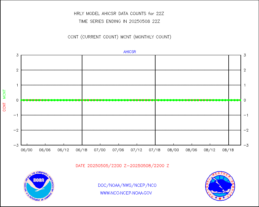
DMSP SSM/IS 1C radiance data (Unified Pre-Proc.) |
112620 |
116428 |
96.7 % |
0120.50-0121.49 |
||||||||||
Synoptic - mobile manual and automatic |
646 |
614 |
105.2 % |
0121.50-0122.49 |
||||||||||
Synoptic - mobile manual & auto (decoded fr BUFR) |
1 |
1 |
100.0 % |
0121.50-0122.49 |
||||||||||
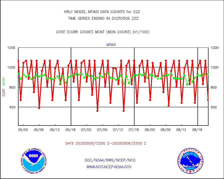
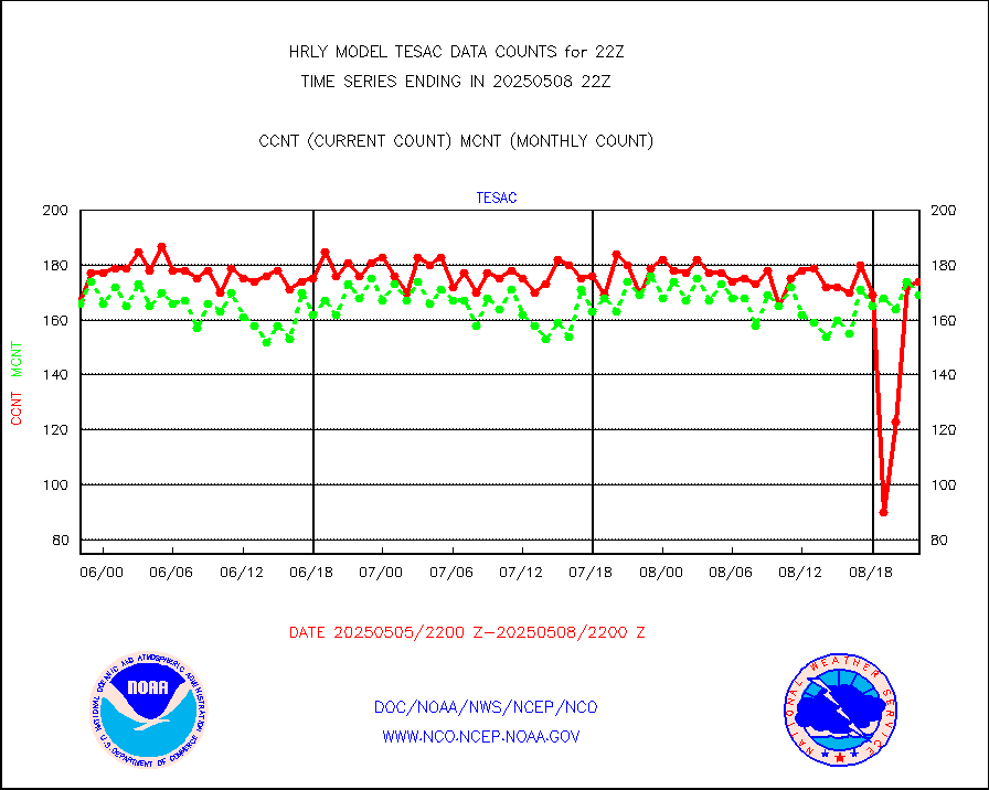
CTD probe, Argo prflng float, mooring (TESAC fmt) |
226 |
210 |
107.6 % |
0121.50-0122.49 |
||||||||||
TAMDAR aircft data-all types(from Panasonic,BUFR) |
54 |
43 |
125.6 % |
0121.50-0122.49 |
||||||||||
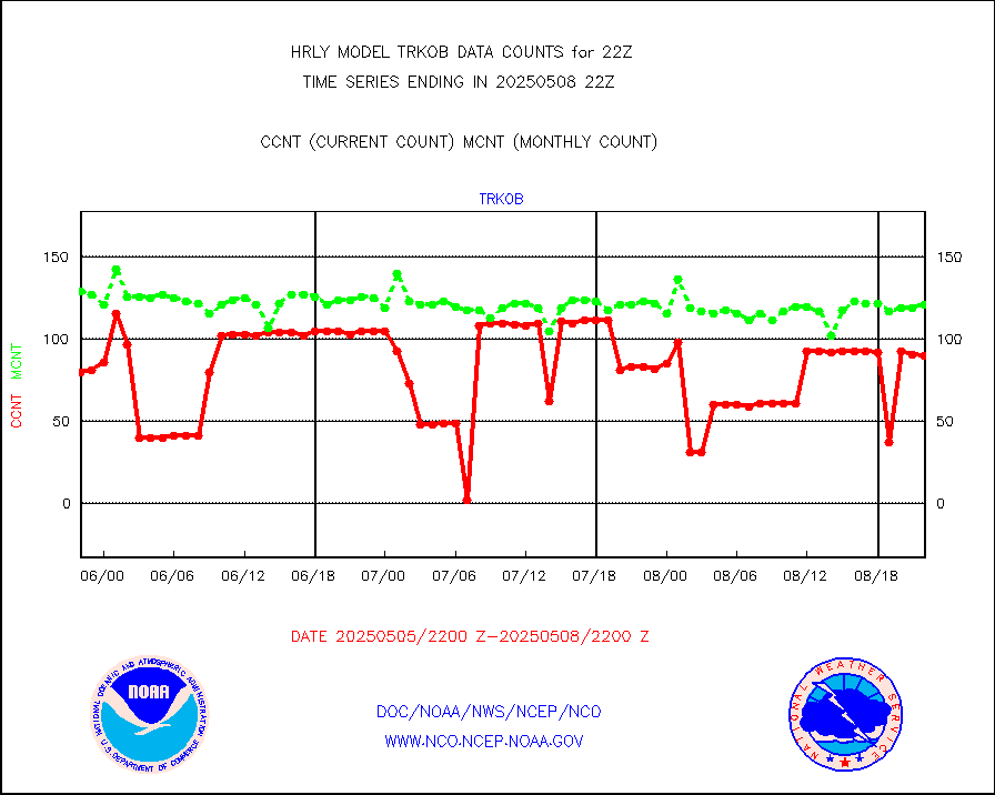
ThermoSalinoGraph (TSG) TRACKOB format) |
91 |
93 |
97.8 % |
0120.50-0121.49 |
||||||||||
INSAT/KALPANA India visible derived cloud motion |
0 |
0 |
n/a |
0119.50-0120.49 |
||||||||||
INDIA SATWIND, INSAT VIS channel |
0 |
0 |
n/a |
0121.00-0121.99 |
||||||||||
MTSAT/JMA visible derived cloud motion |
3538 |
3474 |
101.8 % |
0119.50-0120.49 |
||||||||||
GOES-16&up/NESDIS visible derived cloud motion |
555165 |
492639 |
112.7 % |
0121.00-0121.99 |
||||||||||
METEOSAT/EUMETSAT visible drv cld motion NBseq |
2302 |
1723 |
133.6 % |
0120.50-0121.49 |
||||||||||


