| Suspect Data Shortages in Critical Types - Monitor | ||||||||||||||
|---|---|---|---|---|---|---|---|---|---|---|---|---|---|---|
| Type | Description | Hourly Count | Monthly Average | Percent (%) of Monthly Mean | UTC Time Window | |||||||||
NOAA 18-19 & METOP 1-2 HIRS-4 NCEP-proc. br.temps |
0 |
12073 |
0.0 % |
3019.00-3019.99 |
||||||||||
NOAA 15-19 & METOP 1-2 HIRS-3/4 pr btmps frm RARS |
0 |
6572 |
0.0 % |
3020.50-3021.49 |
||||||||||
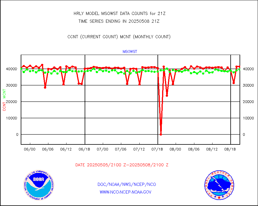
Grnd-based Gbl Navigation Sat System (GNSS) data |
1436 |
6620 |
21.7 % |
3020.00-3020.99 |
||||||||||
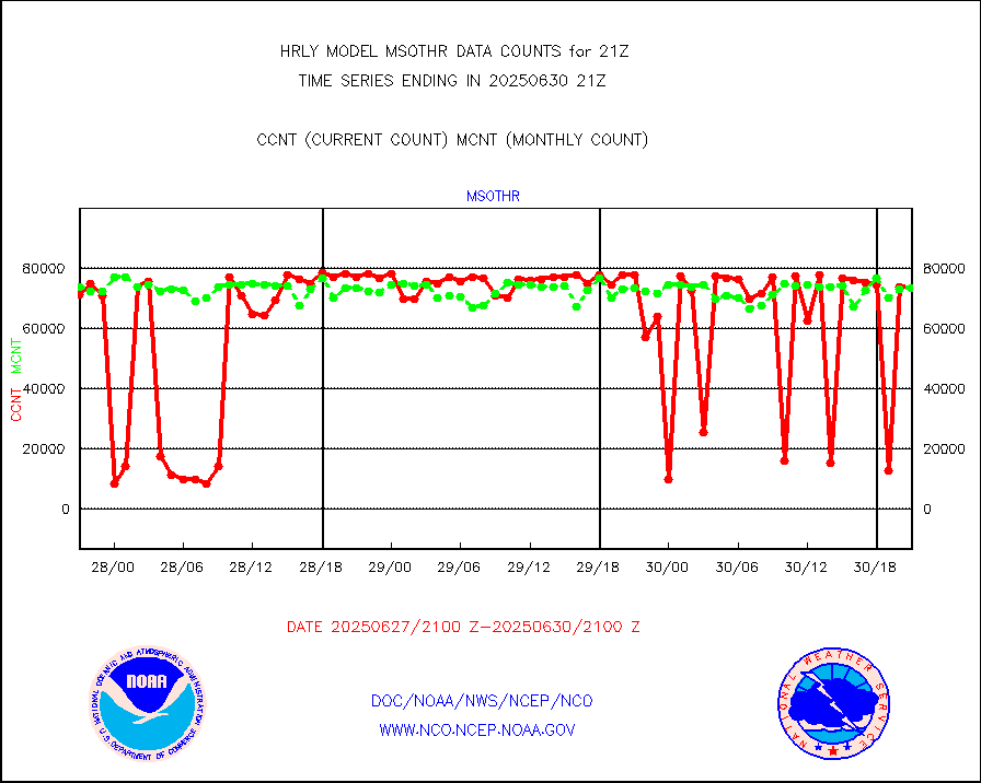
Mesonet/MADIS AWS Convergence Technologies, Inc. |
4897 |
21009 |
23.3 % |
3020.50-3021.49 |
||||||||||
| Shortage in Data Type of Opportunity - Monitor | ||||||||||||||
|---|---|---|---|---|---|---|---|---|---|---|---|---|---|---|
| Type | Description | Hourly Count | Monthly Average | Percent (%) of Monthly Mean | UTC Time Window | |||||||||
P.M.(N18-19) AVHRR GAC NCEP-proc clr & sea btemps |
0 |
472018 |
0.0 % |
3018.50-3019.49 |
||||||||||
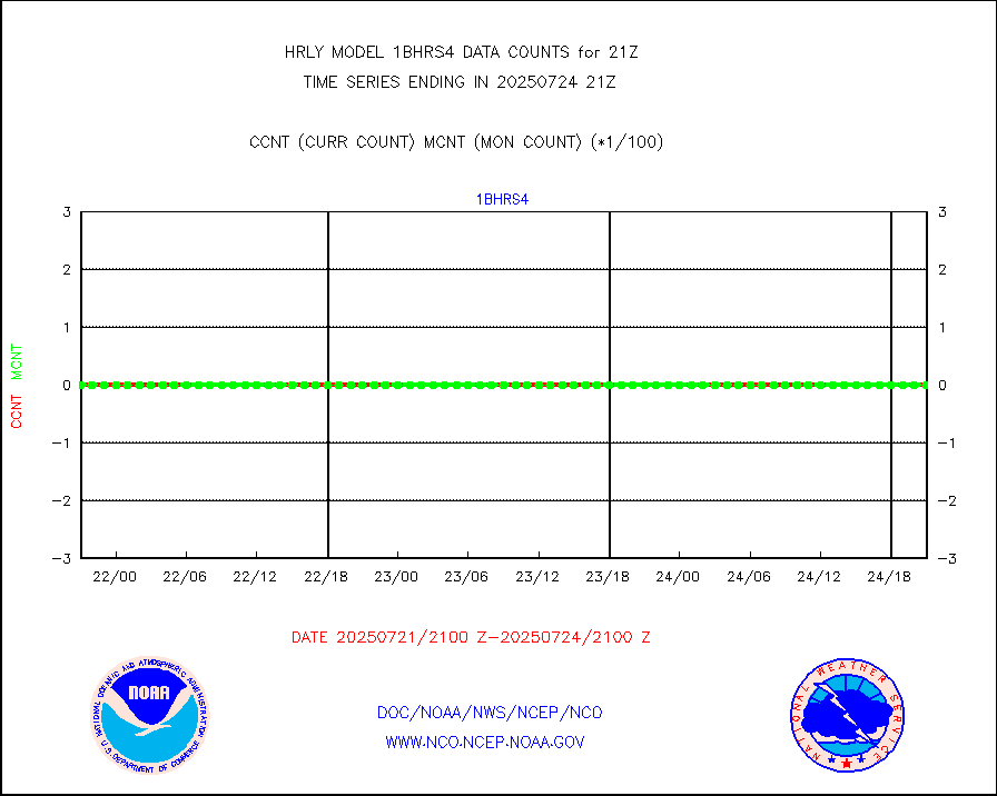
METOP 1-2 IASI 1C radiance data vbl chn from RARS |
0 |
5141 |
0.0 % |
3020.00-3020.99 |
||||||||||
INDIA SATWIND, INSAT WV channel |
0 |
833 |
0.0 % |
3020.00-3020.99 |
||||||||||
INDIA SATWIND, INSAT IR channel |
0 |
1343 |
0.0 % |
3020.00-3020.99 |
||||||||||
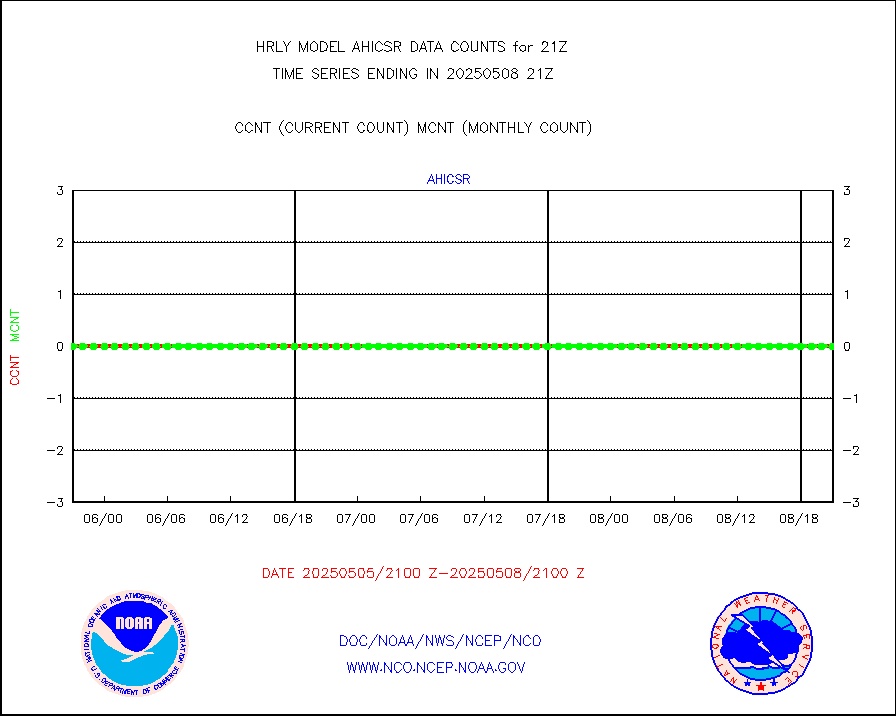
DMSP SSM/IS 1C radiance data (Unified Pre-Proc.) |
0 |
89332 |
0.0 % |
3019.50-3020.49 |
||||||||||
| Critical Data with Normal Counts | ||||||||||||||
|---|---|---|---|---|---|---|---|---|---|---|---|---|---|---|
| Type | Description | Hourly Count | Monthly Average | Percent (%) of Monthly Mean | UTC Time Window | |||||||||
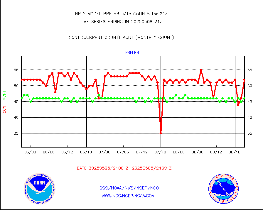
NOAA 15-19 & METOP 1-2 AMSU-A NCEP-proc. br.temps |
26736 |
36085 |
74.1 % |
3019.00-3019.99 |
||||||||||
NOAA 18-19 & METOP 1-2 MHS NCEP-proces. br. temps |
237741 |
267649 |
88.8 % |
3019.00-3019.99 |
||||||||||
MDCRS ACARS acft data from ARINC(dcded from BUFR) |
25171 |
23380 |
107.7 % |
3020.50-3021.49 |
||||||||||
Manual AIREP aircraft data (dcded from AIREP fmt) |
309 |
261 |
118.4 % |
3020.50-3021.49 |
||||||||||
AQUA AIRS/AMSU-A/HSB brightness temps- every FOV |
0 |
0 |
n/a |
3018.50-3019.49 |
||||||||||
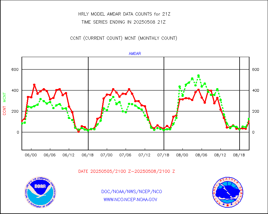
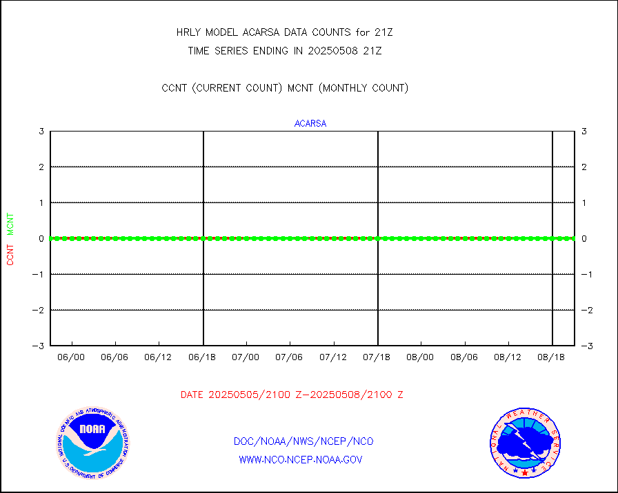
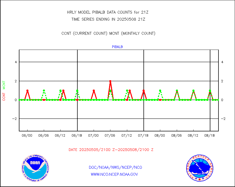
AMDAR aircraft data (decoded from AMDAR format) |
176 |
88 |
200.0 % |
3020.50-3021.49 |
||||||||||
AMDAR aircraft data (decoded from BUFR) |
1469 |
1600 |
91.8 % |
3020.50-3021.49 |
||||||||||
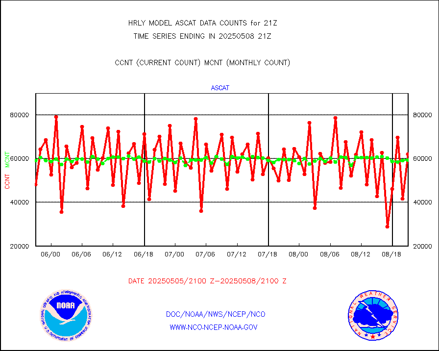
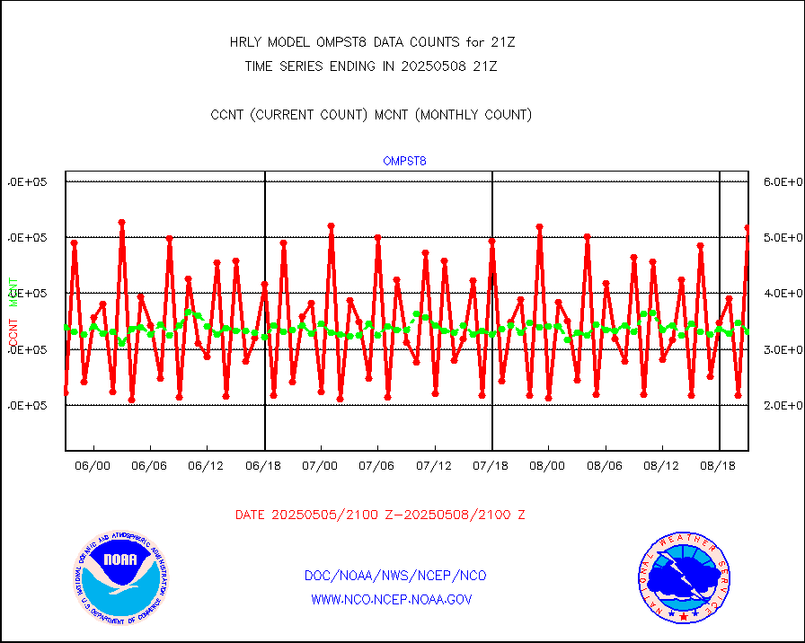
METOP 1-2 ASCAT products |
64218 |
58506 |
109.8 % |
3019.50-3020.49 |
||||||||||
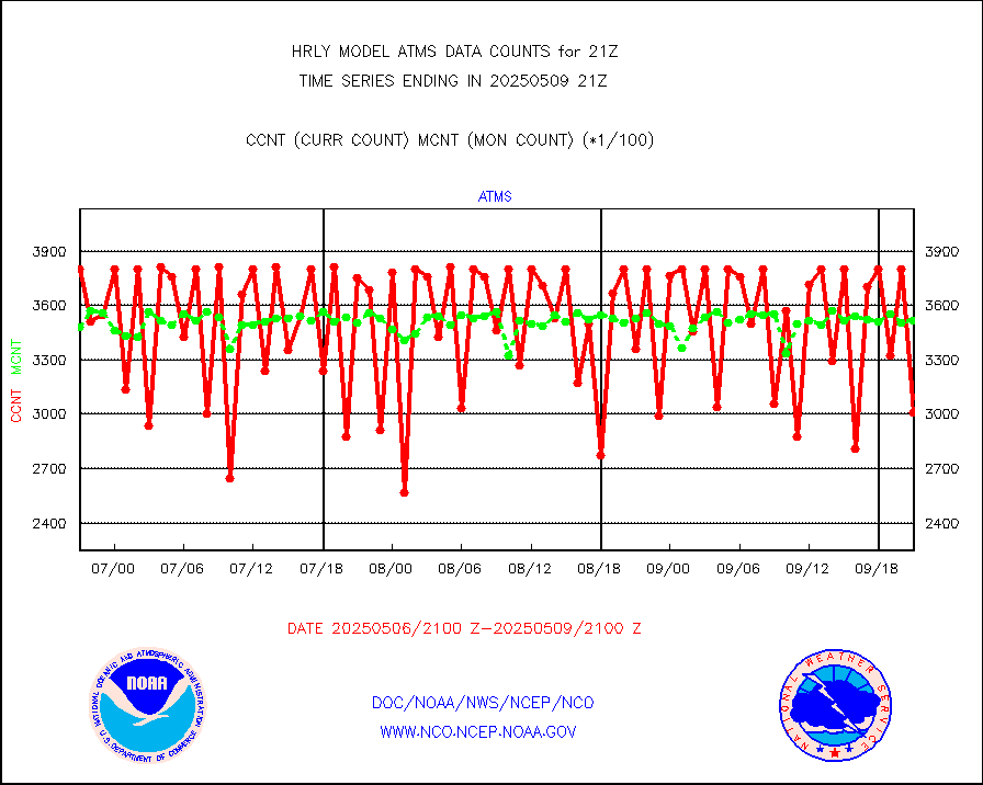
NPP/NOAA-20 ATMS brightness temperatures |
347040 |
344666 |
100.7 % |
3019.50-3020.49 |
||||||||||
Canadian AMDAR aircraft data (decoded from BUFR) |
0 |
0 |
n/a |
3020.50-3021.49 |
||||||||||
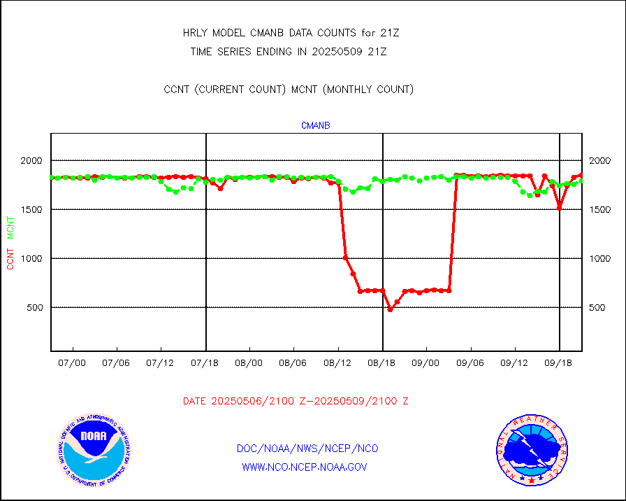
Surface Marine CMAN rpts decoded from BUFR format |
1870 |
1837 |
101.8 % |
3020.50-3021.50 |
||||||||||
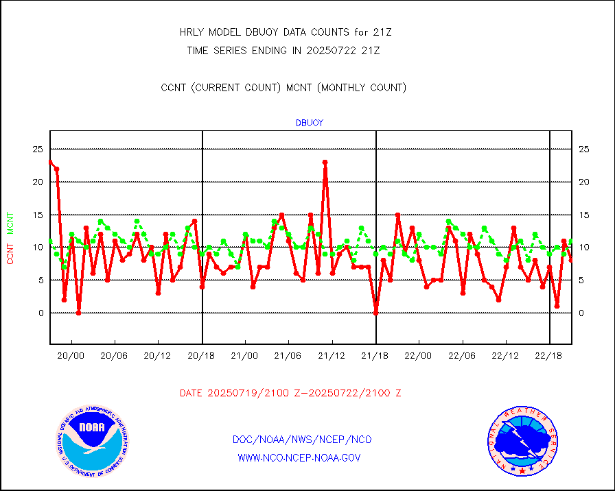
Buoys decoded from FM-18 fmt (moored or drifting) |
3 |
17 |
17.6 % |
3020.50-3021.49 |
||||||||||
E-AMDAR (European AMDAR acft decoded from BUFR) |
1992 |
2081 |
95.7 % |
3020.50-3021.49 |
||||||||||
NOAA 15-19 & METOP 1-2 AMSU-A proc btmps frm RARS |
11846 |
12989 |
91.2 % |
3020.50-3021.49 |
||||||||||
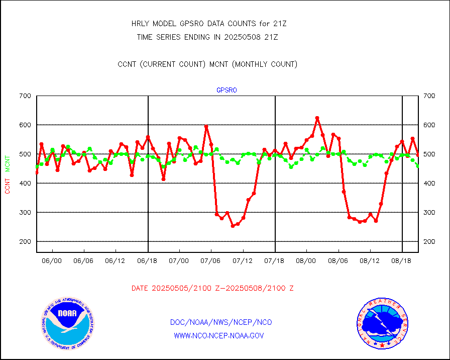
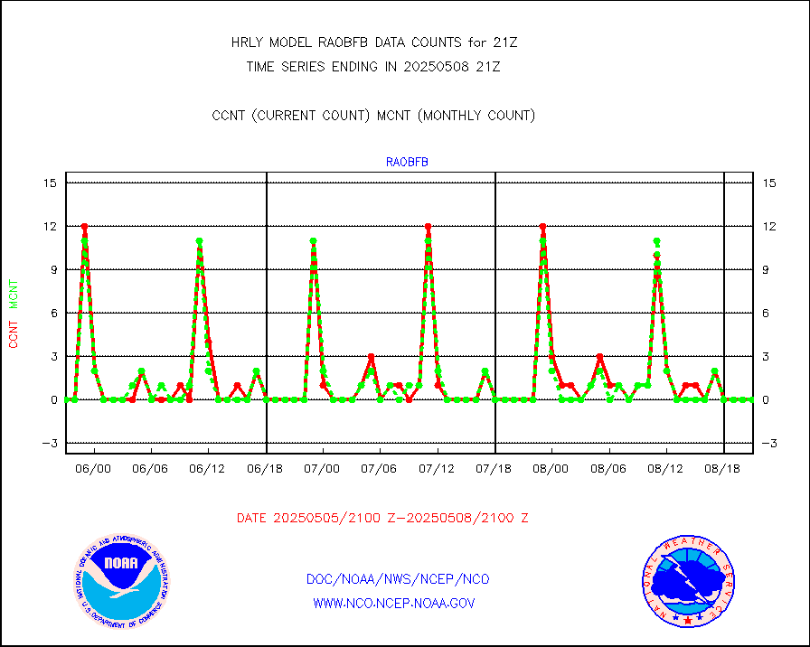
GPS radio occultation data |
468 |
487 |
96.1 % |
3018.50-3019.49 |
||||||||||
GOES-16/17 All Sky Radiances (proc.) |
720952 |
720952 |
100.0 % |
3020.50-3021.49 |
||||||||||
GOES-16/17 Clear Sky Radiances (proc.) |
377449 |
384852 |
98.1 % |
3020.50-3021.49 |
||||||||||
MTSAT/JMA water vapor imager derived cloud motion |
19889 |
18196 |
109.3 % |
3018.50-3019.49 |
||||||||||
MODIS (AQUA/TERRA) wvpr imager derived cld motion |
0 |
0 |
n/a |
3017.00-3017.99 |
||||||||||
GOES-16&up/NESDIS wv imgr/cld-top derived cld mtn |
28809 |
29725 |
96.9 % |
3020.00-3020.99 |
||||||||||
METEOSAT/EUMETSAT ir lg-wave drv cld motion NBseq |
21353 |
20714 |
103.1 % |
3019.50-3020.49 |
||||||||||
MTSAT/JMA infrared long-wave derived cloud motion |
15645 |
14785 |
105.8 % |
3018.50-3019.49 |
||||||||||
MODIS (AQUA/TERRA) ir l-wave derived cloud motion |
0 |
0 |
n/a |
3017.00-3017.99 |
||||||||||
GOES-16&up/NESDIS ir long-wave derived cld motion |
86052 |
85012 |
101.2 % |
3020.00-3020.99 |
||||||||||
GOES/NASA(Langley) hi-res. (1x1 f-o-v) cloud data |
6436768 |
6405250 |
100.5 % |
3020.50-3021.49 |
||||||||||
Buoys decoded from FM-13 format (moored) |
122 |
124 |
98.4 % |
3020.50-3021.49 |
||||||||||
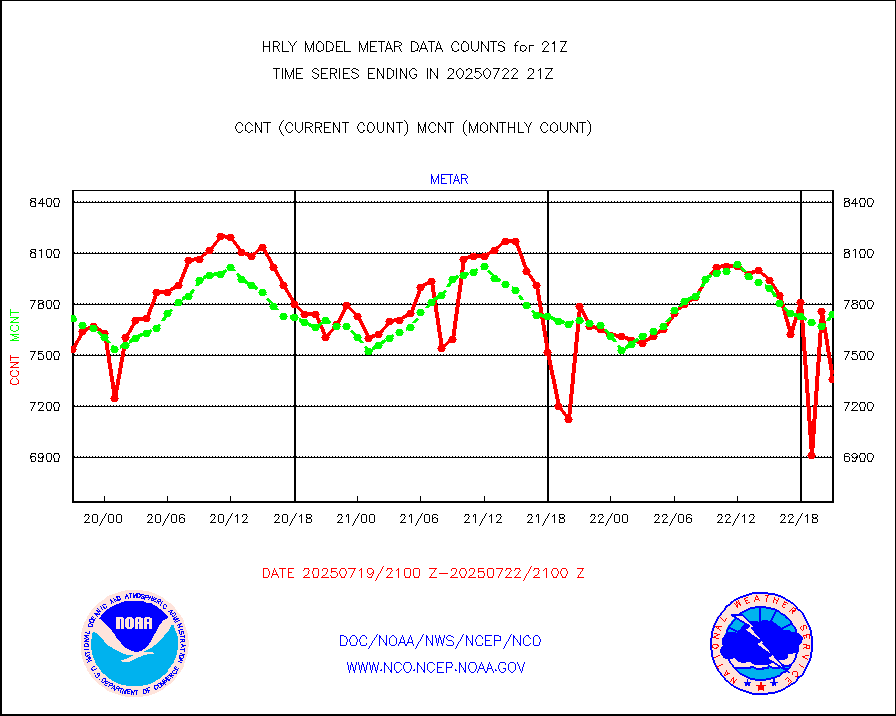
Aviation - METAR |
7847 |
7716 |
101.7 % |
3020.50-3021.49 |
||||||||||
Mesonet/MADIS Colorado E-470 (Interstate 470) |
24 |
24 |
100.0 % |
3020.50-3021.49 |
||||||||||
Mesonet/MADIS Alaska Department of Transportation |
119 |
98 |
121.4 % |
3020.50-3021.49 |
||||||||||
Mesonet/MADIS U.S. Army Aberdeen Proving Grounds |
0 |
0 |
n/a |
3020.50-3021.49 |
||||||||||
Mesonet/MADIS Citizen Weather Observers Program |
60134 |
62910 |
95.6 % |
3020.50-3021.49 |
||||||||||
Mesonet/MADIS "Anything Weather" |
0 |
0 |
n/a |
3020.50-3021.49 |
||||||||||
Mesonet/MADIS Colorado Dept. of Transportation |
0 |
0 |
n/a |
3020.50-3021.49 |
||||||||||
Mesonet/MADIS DC Net |
0 |
0 |
n/a |
3020.50-3021.49 |
||||||||||
Mesonet/MADIS Denver Urban Drainage & Flood Cntrl |
0 |
0 |
n/a |
3020.50-3021.49 |
||||||||||
Mesonet/MADIS Florida (FAWN & USF) |
3 |
4 |
75.0 % |
3020.50-3021.49 |
||||||||||
Mesonet/MADIS Florida Dept. of Transportation |
0 |
0 |
n/a |
3020.50-3021.49 |
||||||||||
Mesonet/MADIS Georgia Dept. of Transportation |
0 |
0 |
n/a |
3020.50-3021.49 |
||||||||||
Mesonet/MADIS NWS Hydromet Auto Data System(HADS) |
5888 |
6093 |
96.6 % |
3020.50-3021.49 |
||||||||||
Mesonet/MADIS Iowa Environmental |
190 |
181 |
105.0 % |
3020.50-3021.49 |
||||||||||
Mesonet/MADIS Indiana Dept. of Transportation |
0 |
0 |
n/a |
3020.50-3021.49 |
||||||||||
Mesonet/MADIS Iowa Department of Transportation |
0 |
0 |
n/a |
3020.50-3021.49 |
||||||||||
Mesonet/MADIS Kansas Department of Transportation |
386 |
368 |
104.9 % |
3020.50-3021.49 |
||||||||||
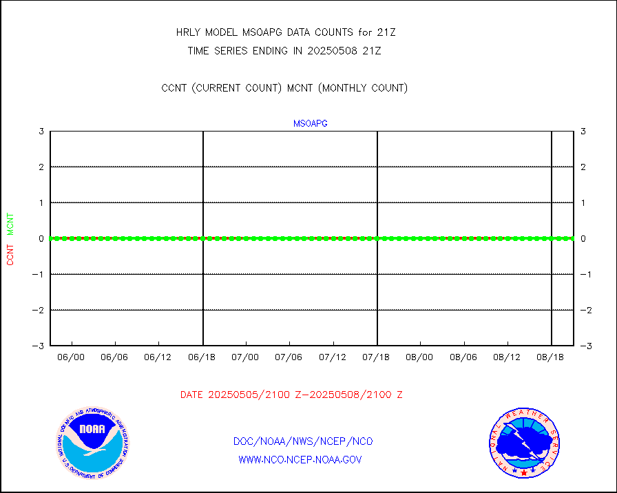
Mesonet/MADIS Oklahoma Mesonet |
630 |
620 |
101.6 % |
3020.50-3021.49 |
||||||||||
Mesonet/MADIS Louisiana State/Jackson State Univ. |
0 |
0 |
n/a |
3020.50-3021.49 |
||||||||||
Mesonet/MADIS Missouri Commercial Agricult Wx Net |
332 |
330 |
100.6 % |
3020.50-3021.49 |
||||||||||
Mesonet/MADIS Minnesota Dept. of Transportation |
0 |
0 |
n/a |
3020.50-3021.49 |
||||||||||
Mesonet/MADIS NOS-Phys Oceanographic Realtime Sys |
377 |
366 |
103.0 % |
3020.50-3021.49 |
||||||||||
Mesonet/MADIS NFIC Remote Automated Wx Stns(RAWS) |
1930 |
1823 |
105.9 % |
3020.50-3021.49 |
||||||||||
Mesonet/MADIS many providers, not separated out |
73509 |
73379 |
100.2 % |
3020.00-3021.49 |
||||||||||
Mesonet/MADIS Virginia Dept. of Transportation |
0 |
0 |
n/a |
3020.50-3021.49 |
||||||||||
Mesonet/MADIS "Weather for You" |
0 |
0 |
n/a |
3020.50-3021.49 |
||||||||||
Mesonet/MADIS Wisconsin Dept. of Transportation |
0 |
0 |
n/a |
3020.50-3021.49 |
||||||||||
Mesonet/MADIS MesoWest (many subproviders) |
37727 |
37911 |
99.5 % |
3020.50-3021.49 |
||||||||||
Mesonet/MADIS West Texas |
5858 |
5996 |
97.7 % |
3020.50-3021.49 |
||||||||||
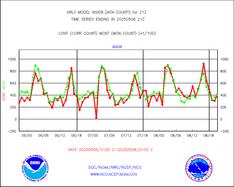
METOP 1-2 IASI 1C radiance data (varbl. channels) |
106924 |
89761 |
119.1 % |
3019.00-3019.99 |
||||||||||
NEXRAD Vel Azm Dsp(VAD) winds via radar coded msg |
0 |
0 |
n/a |
3020.50-3021.49 |
||||||||||
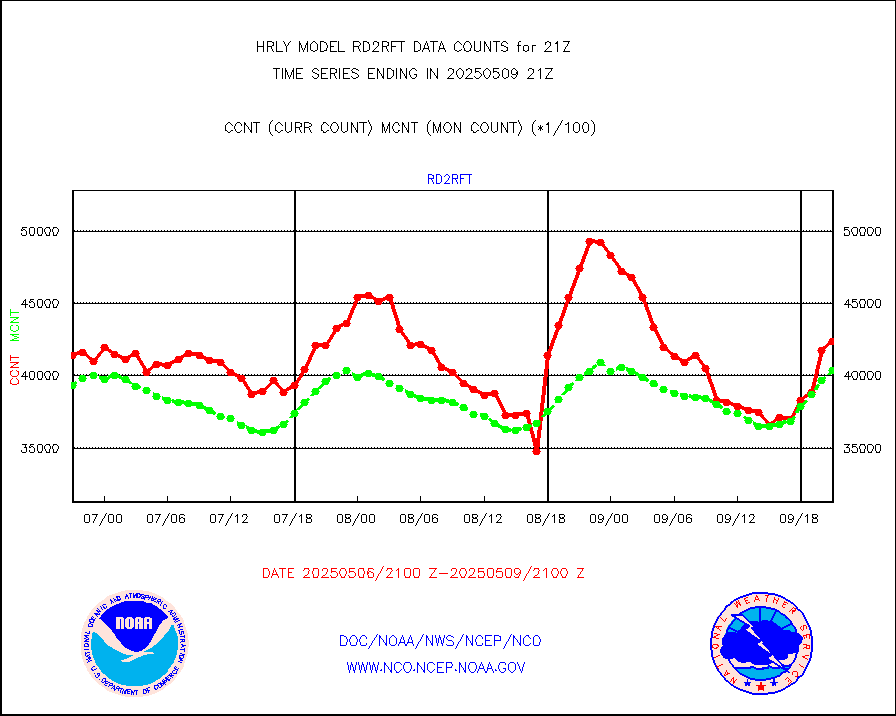
Aura Ozone Monitoring Instrument (OMI) data |
0 |
0 |
n/a |
3018.50-3019.49 |
||||||||||
NOAA 16-19 Solar Backscatter UV-2 rad frm V8 BUFR |
0 |
0 |
n/a |
3019.00-3019.99 |
||||||||||
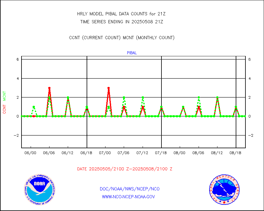
PIBAL (from PILOT, PILOT SHIP, PILOT MOBIL) |
0 |
0 |
n/a |
3020.50-3021.49 |
||||||||||
Multi-Agency Profiler (MAP) and SODAR winds |
44 |
44 |
100.0 % |
3020.50-3021.49 |
||||||||||
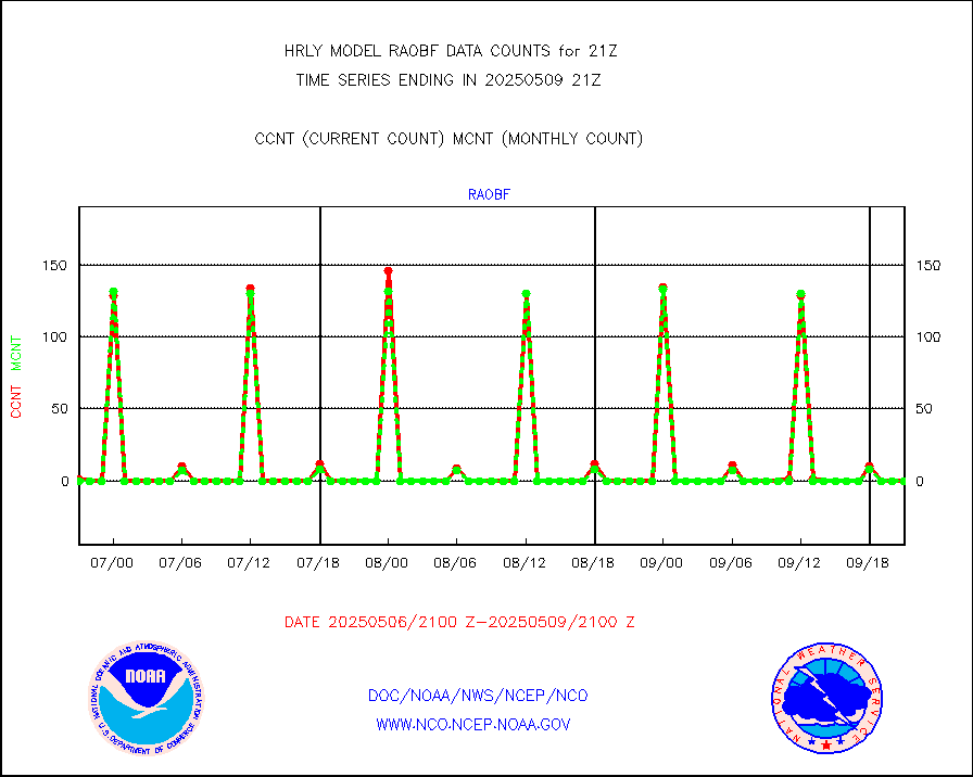
Rawinsonde - fixed land (from TEMP or PILOT) |
0 |
0 |
n/a |
3020.50-3021.49 |
||||||||||
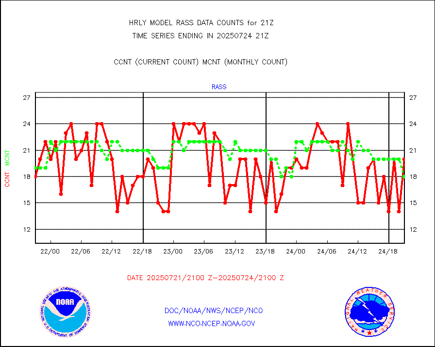
RASS temperatures (NOAA and Multi-Agency) |
20 |
23 |
87.0 % |
3020.50-3021.49 |
||||||||||
NEXRAD reflectivity (Lvl 2 - GTS) |
4975633 |
4580366 |
108.6 % |
3020.50-3021.49 |
||||||||||
NEXRAD radial wind (Level 2 - GTS) |
2023403 |
1704008 |
118.7 % |
3020.50-3021.49 |
||||||||||
METEOSAT-10 2nd Gen SEVIRI Clr Sky Radiance(proc) |
0 |
0 |
n/a |
3020.50-3021.49 |
||||||||||
Ship - manual and automatic, restricted (BUFR) |
0 |
1 |
0.0 % |
3020.50-3021.50 |
||||||||||
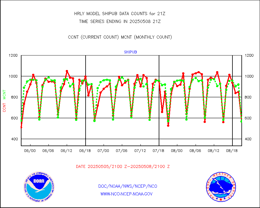
Ship - manual and automatic, unrestricted |
154 |
149 |
103.4 % |
3020.50-3021.50 |
||||||||||
Ship - manual and automatic, unrestricted (BUFR) |
437 |
523 |
83.6 % |
3020.50-3021.50 |
||||||||||
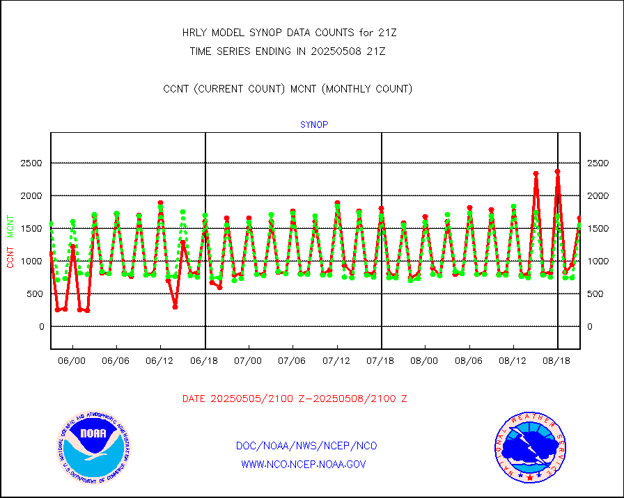
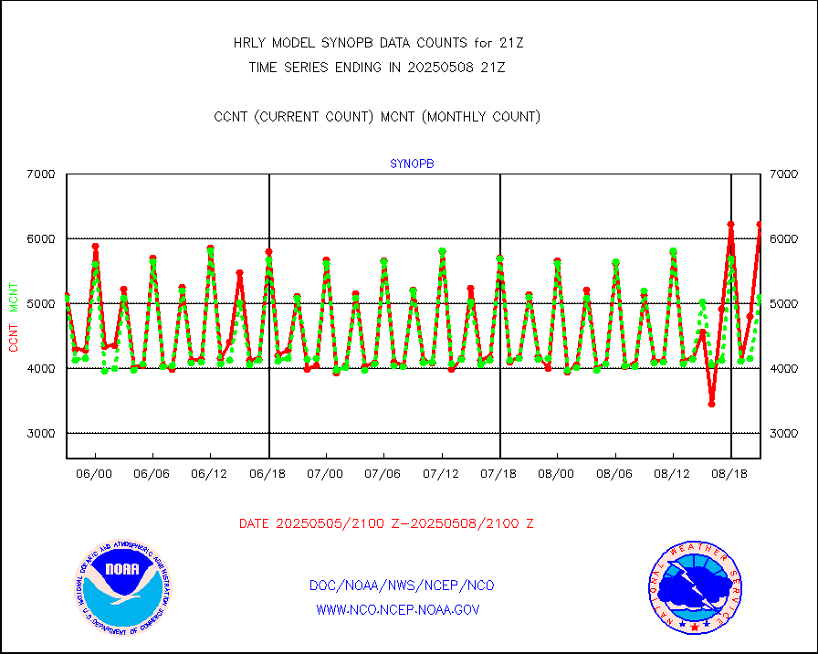
Synoptic - fixed manual and automatic |
1586 |
1546 |
102.6 % |
3020.50-3021.49 |
||||||||||
Synoptic - fixed manual & auto (decoded fr BUFR) |
6118 |
6133 |
99.8 % |
3020.50-3021.49 |
||||||||||
Synoptic - restricted (WMO Res 40) manual & auto. |
2 |
1 |
200.0 % |
3020.50-3021.49 |
||||||||||
Synoptic - restricted (WMO Res 40)(decoded BUFR) |
357 |
364 |
98.1 % |
3020.50-3021.49 |
||||||||||
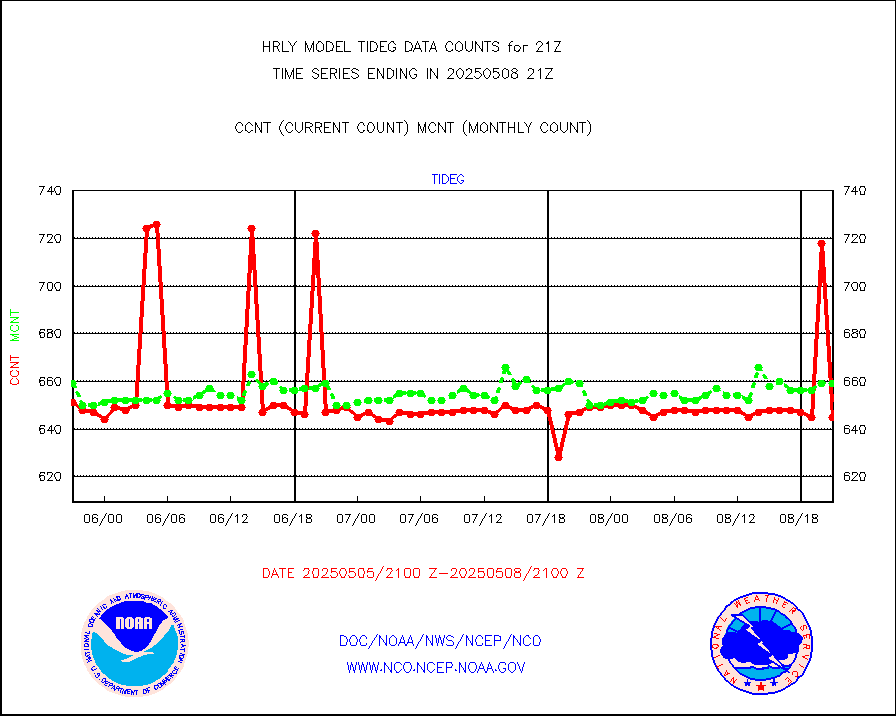
Tide gauge reports decoded from CREX format |
655 |
658 |
99.5 % |
3020.00-3020.99 |
||||||||||
| Data Types of Opportunity with Normal Counts | ||||||||||||||
|---|---|---|---|---|---|---|---|---|---|---|---|---|---|---|
| Type | Description | Hourly Count | Monthly Average | Percent (%) of Monthly Mean | UTC Time Window | |||||||||
GOES-16&up/NESDIS ir short-wv derived cld motion |
2706 |
2814 |
96.2 % |
3020.00-3020.99 |
||||||||||
MDCRS ACARS acft data (ARINC via AFWA)(AIREP fmt) |
0 |
0 |
n/a |
3020.50-3021.49 |
||||||||||
Himawari Clear Sky Radiance |
0 |
0 |
n/a |
3020.00-3020.99 |
||||||||||
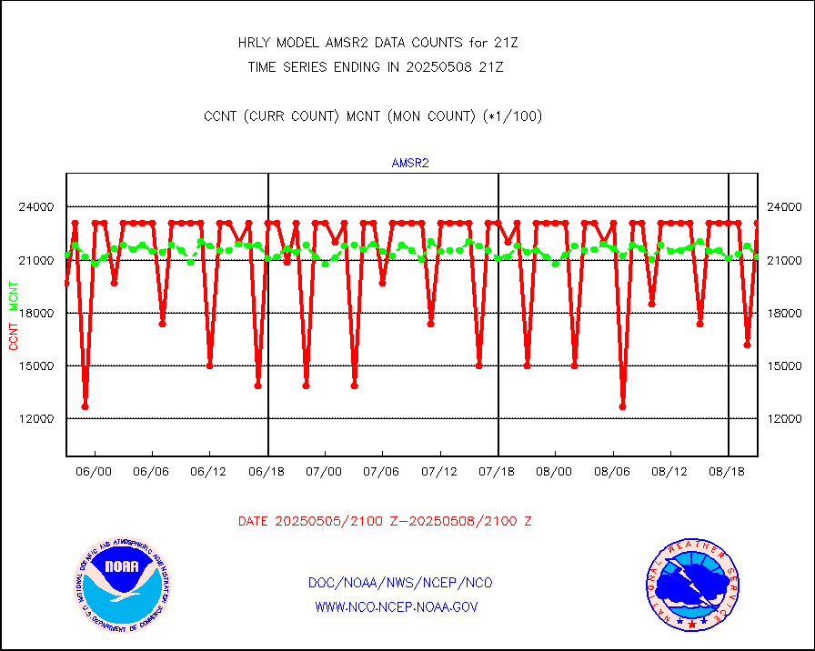
GCOM-W AMSR2 1B brightness temperatures |
2310444 |
2062746 |
112.0 % |
3019.00-3019.99 |
||||||||||
NPP/NOAA-20 ATMS bright. temps-direct b-cast SSEC |
161315 |
131773 |
122.4 % |
3019.50-3020.49 |
||||||||||
POES/NESDIS - processed ATOVS soundings/radiances |
0 |
0 |
n/a |
3019.00-3019.99 |
||||||||||
A.M.(N17,M2,M3) AVHRR GAC NCEP-proc clr&sea btmps |
1141730 |
1261651 |
90.5 % |
3018.50-3019.49 |
||||||||||
eXpendable BathyThermograph, mooring (BATHY fmt) |
0 |
0 |
n/a |
3014.00-3014.99 |
||||||||||
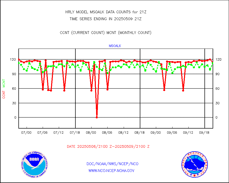
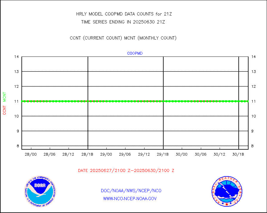
Coop/MADIS NEPP & HCN-Modernization NOAA COOP Obs |
11 |
11 |
100.0 % |
3020.50-3021.49 |
||||||||||
NPP/NOAA-20 CrIS full spctrl radn (431 ch subset) |
240534 |
215657 |
111.5 % |
3019.50-3020.49 |
||||||||||
NPP/NOAA-20 CrIS full spctrl radn dir brdcst SSEC |
53784 |
46183 |
116.5 % |
3019.50-3020.49 |
||||||||||
Coast Guard |
10 |
7 |
142.9 % |
3020.50-3021.50 |
||||||||||
Drifting buoys (decoded from BUFR) |
1432 |
1435 |
99.8 % |
3020.50-3021.50 |
||||||||||
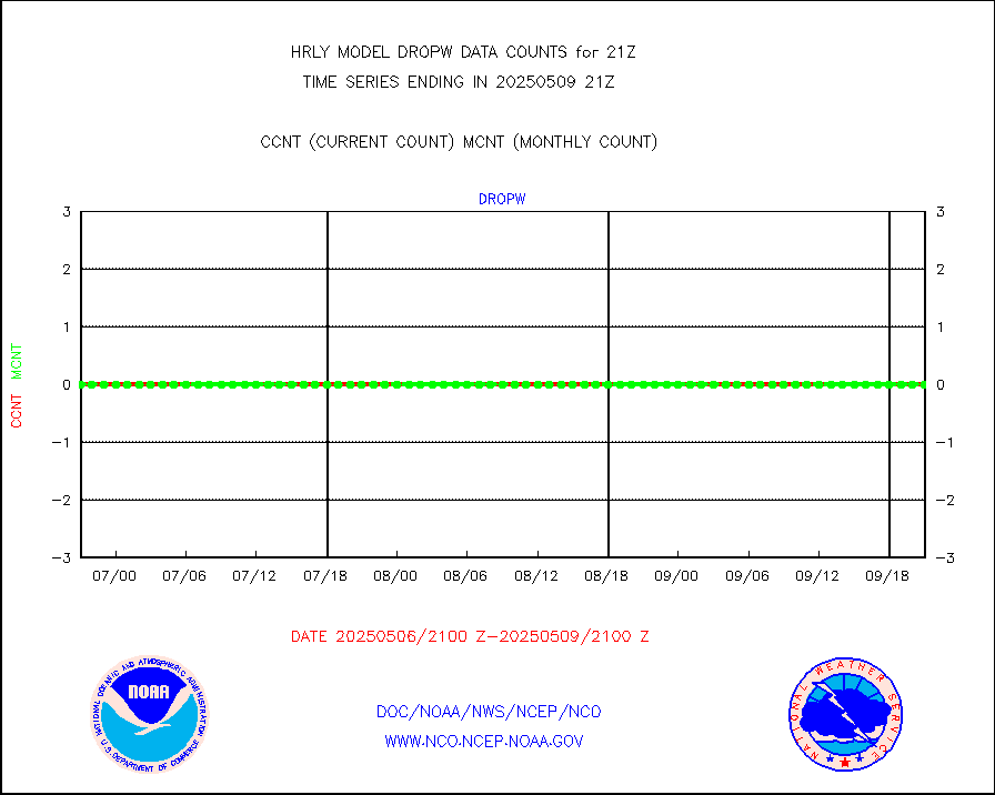
Dropwinsonde (from TEMP DROP) |
0 |
0 |
n/a |
3020.50-3021.49 |
||||||||||
Dropwinsonde (decoded from BUFR) |
0 |
0 |
n/a |
3020.51-3021.49 |
||||||||||
GOES imager effective cloud amount data (U.Wisc.) |
8535568 |
7966530 |
107.1 % |
3020.50-3021.49 |
||||||||||
NPP Adv. Tech. MW Sndr (ATMS) br. temps from RARS |
11520 |
10092 |
114.1 % |
3019.50-3020.49 |
||||||||||
NOAA 18-19 & METOP 1-2 MHS proc. btemps from RARS |
95575 |
124056 |
77.0 % |
3020.50-3021.49 |
||||||||||
GOES/NESDIS (11x17 f-o-v) imager clear radiances |
0 |
0 |
n/a |
3020.00-3020.99 |
||||||||||
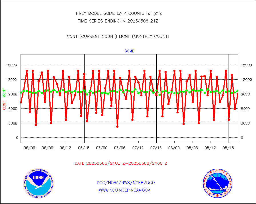
METOP 1-2 Global Ozone Monitoring Exp.-2 (GOME-2) |
10175 |
8756 |
116.2 % |
3019.50-3020.49 |
||||||||||
GOES-16&up/NESDIS wv imgr/deep-lyr derivd cld mtn |
20724 |
17545 |
118.1 % |
3020.00-3020.99 |
||||||||||
METEOSAT/EUMETSAT wvpr imgr drv cld motion NBseq |
36360 |
37079 |
98.1 % |
3019.50-3020.49 |
||||||||||
High Density OBs from reconnaissance acft data |
0 |
26 |
0.0 % |
3020.50-3021.49 |
||||||||||
METOP 1-2 IASI 1C radiances-direct broadcast SSEC |
35472 |
42258 |
83.9 % |
3019.50-3020.49 |
||||||||||
VIIRS (NPP/NOAA-20) ir lg-wv drv cloud motion(NB) |
13153 |
15629 |
84.2 % |
3017.00-3017.99 |
||||||||||
AVHRR (NOAA/METOP) ir lg-wave derived cld motion |
0 |
0 |
n/a |
3017.00-3017.99 |
||||||||||
AVHRR (METOP) ir lg-wave derived cld motion |
0 |
0 |
n/a |
3020.50-3021.50 |
||||||||||
INSAT/KALPANA India ir lg-wave derived cld motion |
0 |
0 |
n/a |
3018.50-3019.49 |
||||||||||
Korean AMDAR aircraft data (decoded from BUFR) |
0 |
0 |
n/a |
3020.50-3021.49 |
||||||||||
Land-based CMAN stations decoded from CMAN format |
68 |
77 |
88.3 % |
3020.50-3021.49 |
||||||||||
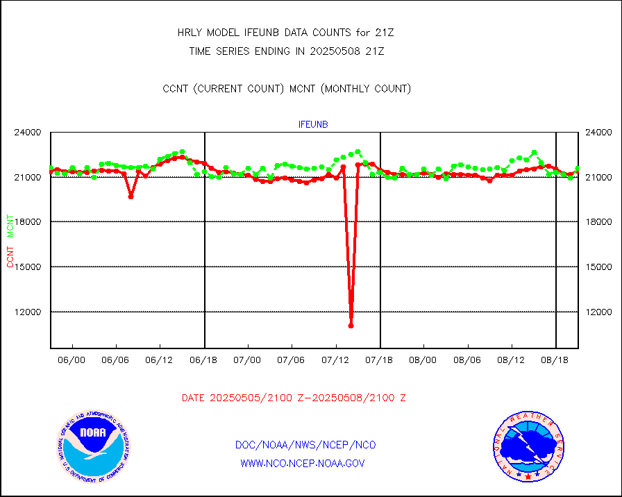
LEO-GEO satellite AMVs from UWisc. |
7238 |
7472 |
96.9 % |
3017.00-3017.99 |
||||||||||
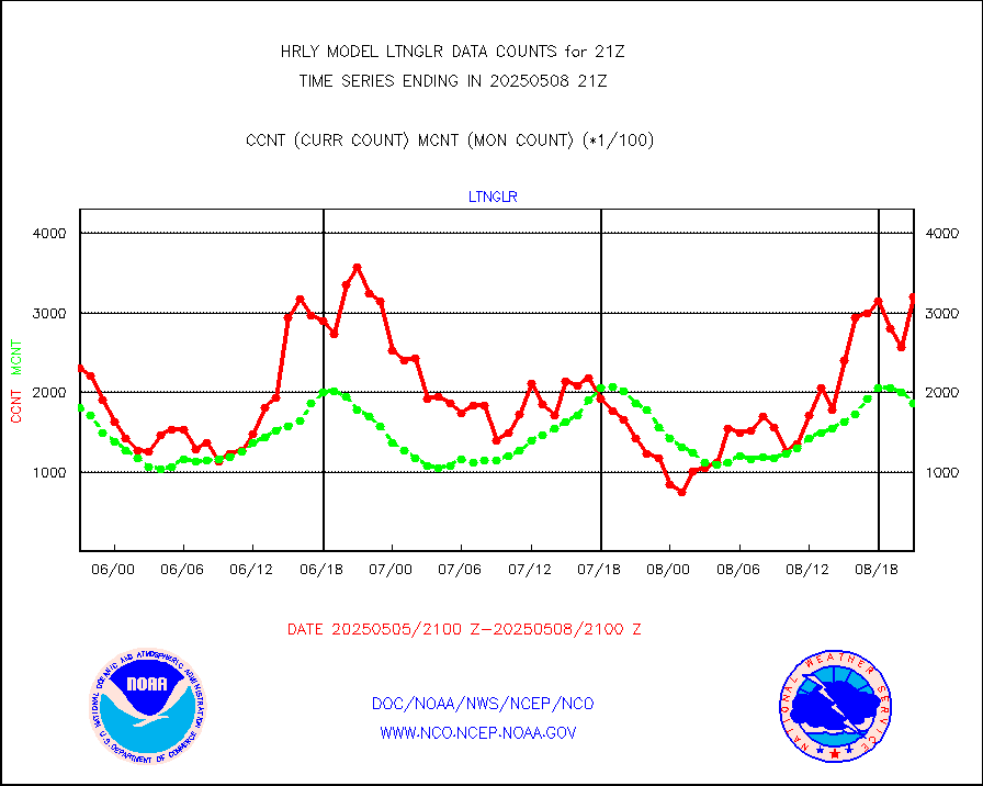
LLDN Long-rng lightning from Vaisala via NOAAPORT |
311839 |
250765 |
124.4 % |
3020.50-3021.49 |
||||||||||
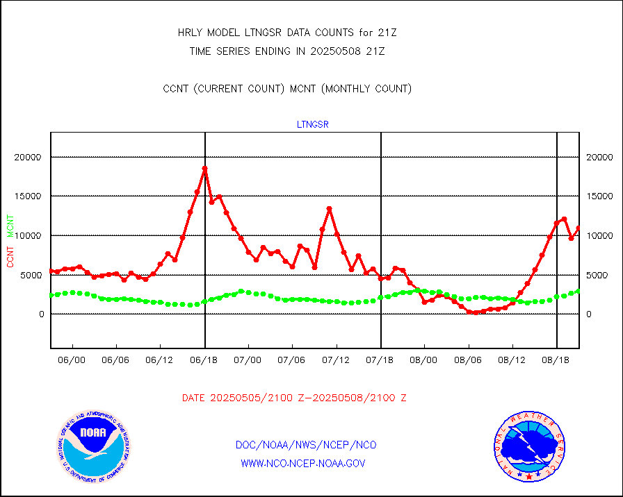
NLDN Shrt-rng lightning from Vaisala via NOAAPORT |
13091 |
10090 |
129.7 % |
3020.50-3021.49 |
||||||||||
Moored buoys (decoded from BUFR) |
959 |
916 |
104.7 % |
3020.50-3021.50 |
||||||||||
Aura Microwave Limb Sounder (MLS) ozone data |
0 |
0 |
n/a |
3019.00-3019.99 |
||||||||||
Mesonet/MADIS UrbaNet |
3263 |
3562 |
91.6 % |
3020.50-3021.49 |
||||||||||
NEXRAD Vel Azm Dsp(VAD) winds via Level 2 decoder |
404 |
406 |
99.5 % |
3020.50-3021.49 |
||||||||||
OMPS Limb Profiler ozone data (NPP) |
197 |
267 |
73.8 % |
3014.00-3014.99 |
||||||||||
OMPS nadir profile ozone (Version 8 BUFR) |
526 |
554 |
94.9 % |
3019.00-3019.99 |
||||||||||
OMPS total column ozone (Version 8 BUFR) |
470938 |
324353 |
145.2 % |
3019.00-3019.99 |
||||||||||
PIBAL (decoded from BUFR) |
0 |
0 |
n/a |
3020.51-3021.49 |
||||||||||
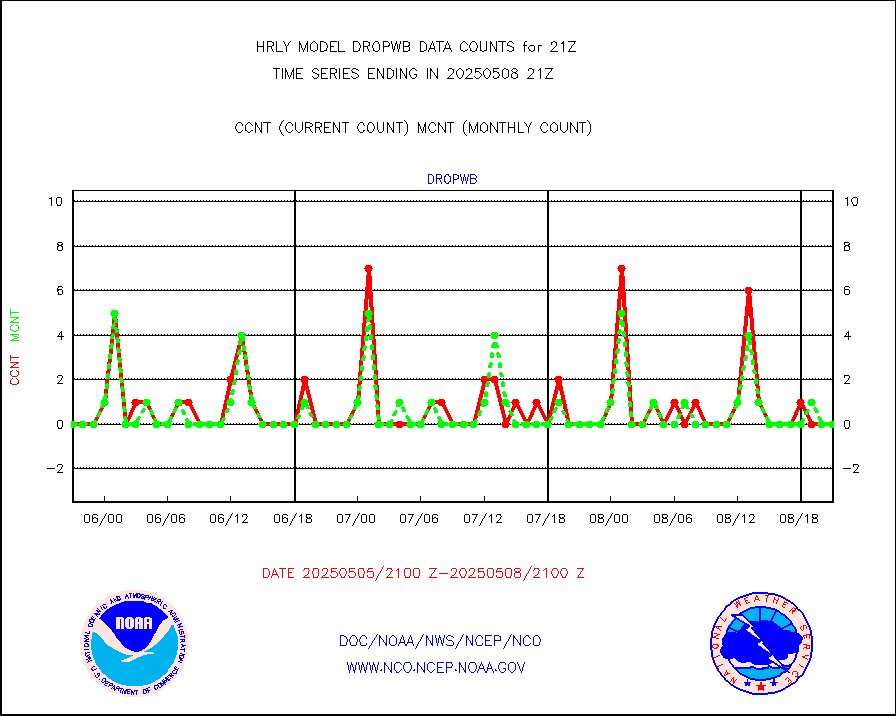
Manual PIREP aircraft data (dcded from AIREP fmt) |
144 |
119 |
121.0 % |
3020.50-3021.49 |
||||||||||
Profilr winds from PIBAL (PILOT,PILOT SHIP/MOBIL) |
0 |
0 |
n/a |
3020.50-3021.49 |
||||||||||
Rawinsonde - fixed land (decoded from BUFR) |
0 |
0 |
n/a |
3020.51-3021.49 |
||||||||||
Rawinsonde - mobile land (from TEMP/PILOT MOBIL) |
0 |
0 |
n/a |
3020.50-3021.49 |
||||||||||
Rawinsonde - mobile land (decoded from BUFR) |
0 |
0 |
n/a |
3020.51-3021.49 |
||||||||||
Rawinsonde - ship (from TEMP SHIP, PILOT SHIP) |
0 |
0 |
n/a |
3020.50-3021.49 |
||||||||||
Rawinsonde - ship (decoded from BUFR) |
0 |
0 |
n/a |
3020.51-3021.49 |
||||||||||
Flight level reconnaissance aircraft data |
0 |
0 |
n/a |
3020.50-3021.49 |
||||||||||
Megha-Tropiques SAPHIR L1A2 brightness temps |
0 |
0 |
n/a |
3018.50-3019.49 |
||||||||||
METEOSAT-10 2nd Gen SEVIRI All Sky Radiance(proc) |
75512 |
75438 |
100.1 % |
3020.50-3021.49 |
||||||||||
Ship - manual and automatic, restricted |
3 |
5 |
60.0 % |
3020.50-3021.49 |
||||||||||
NPP/NOAA-20 VIIRS SST - CLEAR & OVER WATER |
671316 |
859913 |
78.1 % |
3020.50-3021.49 |
||||||||||
NPP/NOAA-20 VIIRS SST - PROBABLY CLR & OVER WATER |
180793 |
227658 |
79.4 % |
3020.50-3021.49 |
||||||||||
Synoptic - mobile manual and automatic |
647 |
633 |
102.2 % |
3020.50-3021.49 |
||||||||||
Synoptic - mobile manual & auto (decoded fr BUFR) |
1 |
1 |
100.0 % |
3020.50-3021.49 |
||||||||||
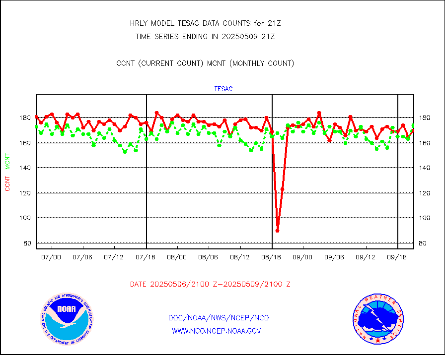
CTD probe, Argo prflng float, mooring (TESAC fmt) |
228 |
216 |
105.6 % |
3020.50-3021.49 |
||||||||||
TAMDAR aircft data-all types(from Panasonic,BUFR) |
24 |
42 |
57.1 % |
3020.50-3021.49 |
||||||||||
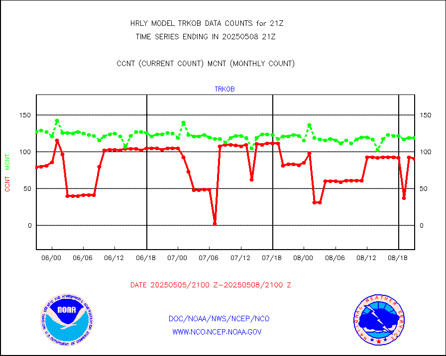
ThermoSalinoGraph (TSG) TRACKOB format) |
61 |
94 |
64.9 % |
3019.50-3020.49 |
||||||||||
INSAT/KALPANA India visible derived cloud motion |
0 |
0 |
n/a |
3018.50-3019.49 |
||||||||||
INDIA SATWIND, INSAT VIS channel |
0 |
0 |
n/a |
3020.00-3020.99 |
||||||||||
MTSAT/JMA visible derived cloud motion |
2520 |
2255 |
111.8 % |
3018.50-3019.49 |
||||||||||
GOES-16&up/NESDIS visible derived cloud motion |
562137 |
511280 |
109.9 % |
3020.00-3020.99 |
||||||||||
METEOSAT/EUMETSAT visible drv cld motion NBseq |
7519 |
5793 |
129.8 % |
3019.50-3020.49 |
||||||||||


