| Suspect Data Shortages in Critical Types - Monitor | ||||||||||||||
|---|---|---|---|---|---|---|---|---|---|---|---|---|---|---|
| Type | Description | Hourly Count | Monthly Average | Percent (%) of Monthly Mean | UTC Time Window | |||||||||
NOAA 18-19 & METOP 1-2 HIRS-4 NCEP-proc. br.temps |
0 |
5455 |
0.0 % |
0415.00-0420.99 |
||||||||||
| Shortage in Data Type of Opportunity - Monitor | ||||||||||||||
|---|---|---|---|---|---|---|---|---|---|---|---|---|---|---|
| Type | Description | Hourly Count | Monthly Average | Percent (%) of Monthly Mean | UTC Time Window | |||||||||
NOAA 15-19 & METOP 1-2 HIRS-3/4 pr btmps frm RARS |
0 |
2371 |
0.0 % |
0417.00-0419.00 |
||||||||||
| Critical Data with Normal Counts | ||||||||||||||
|---|---|---|---|---|---|---|---|---|---|---|---|---|---|---|
| Type | Description | Hourly Count | Monthly Average | Percent (%) of Monthly Mean | UTC Time Window | |||||||||
NOAA 15-19 & METOP 1-2 AMSU-A NCEP-proc. br.temps |
13979 |
16945 |
82.5 % |
0415.00-0420.99 |
||||||||||
NOAA 18-19 & METOP 1-2 MHS NCEP-proces. br. temps |
124252 |
136024 |
91.3 % |
0415.00-0420.99 |
||||||||||
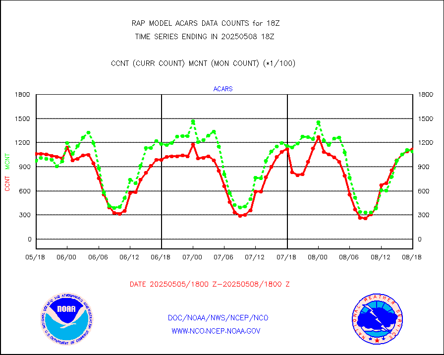
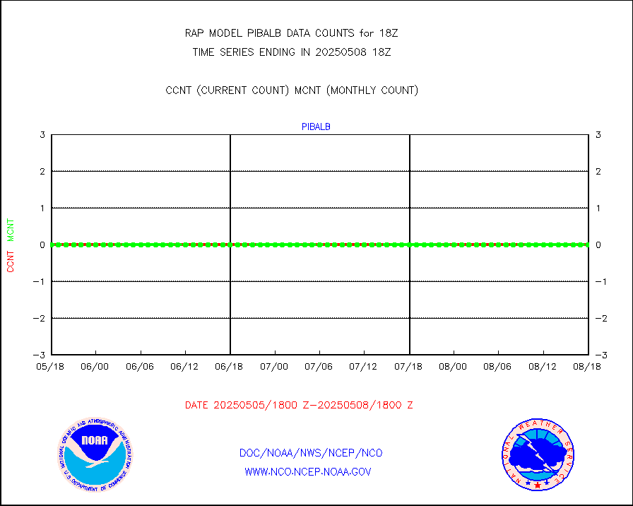
MDCRS ACARS acft data from ARINC(dcded from BUFR) |
115253 |
118765 |
97.0 % |
0414.75-0421.25 |
||||||||||
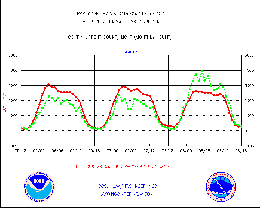
Canadian AMDAR aircraft data (decoded from BUFR) |
0 |
0 |
n/a |
0414.75-0421.25 |
||||||||||
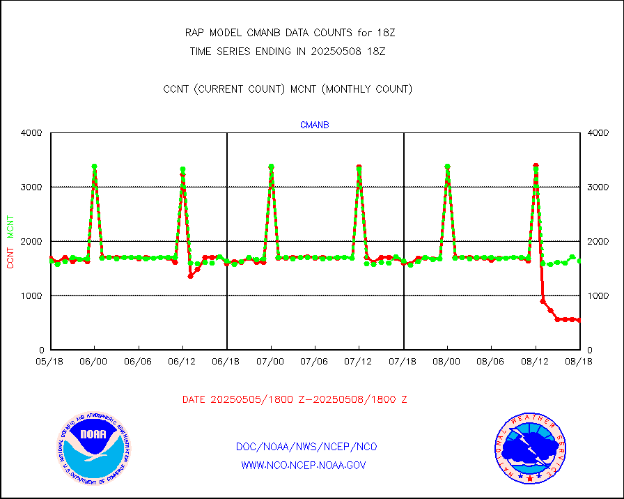
Surface Marine CMAN rpts decoded from BUFR format |
1733 |
1663 |
104.2 % |
0417.50-0418.50 |
||||||||||
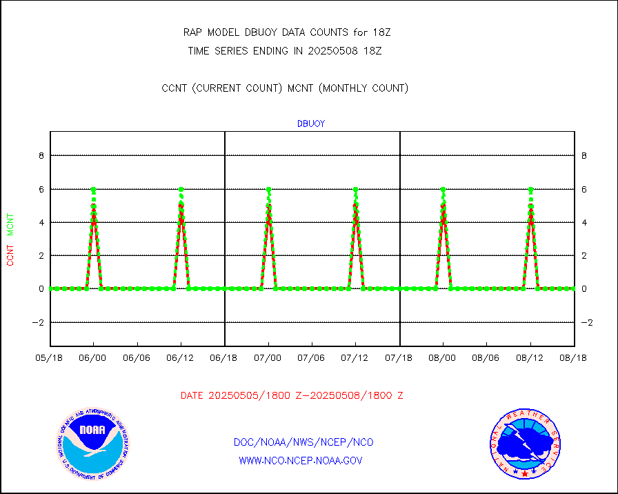
Buoys decoded from FM-18 fmt (moored or drifting) |
0 |
0 |
n/a |
0417.50-0418.50 |
||||||||||
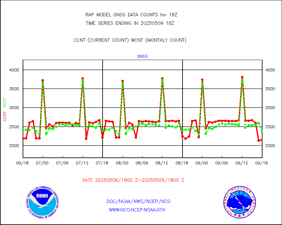
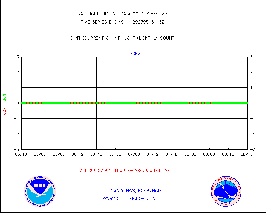
Grnd-based Gbl Navigation Sat System (GNSS) data |
2754 |
1855 |
148.5 % |
0416.95-0417.05 |
||||||||||
MODIS (AQUA/TERRA) wvpr imager derived cld motion |
0 |
0 |
n/a |
0415.50-0420.50 |
||||||||||
MODIS (AQUA/TERRA) ir l-wave derived cloud motion |
0 |
0 |
n/a |
0415.50-0420.50 |
||||||||||
GOES/NASA(Langley) hi-res. (1x1 f-o-v) cloud data |
1876086 |
1873142 |
100.2 % |
0417.50-0418.50 |
||||||||||
Buoys decoded from FM-13 format (moored) |
187 |
135 |
138.5 % |
0417.50-0418.50 |
||||||||||
Aviation - METAR |
5618 |
5564 |
101.0 % |
0417.50-0418.50 |
||||||||||
NEXRAD Vel Azm Dsp(VAD) winds via radar coded msg |
0 |
0 |
n/a |
0417.00-0419.00 |
||||||||||
Multi-Agency Profiler (MAP) and SODAR winds |
82 |
95 |
86.3 % |
0416.50-0419.50 |
||||||||||
Rawinsonde - fixed land (from TEMP or PILOT) |
11 |
8 |
137.5 % |
0417.00-0419.00 |
||||||||||
RASS temperatures (NOAA and Multi-Agency) |
19 |
21 |
90.5 % |
0417.50-0418.50 |
||||||||||
Ship - manual and automatic, restricted (BUFR) |
0 |
0 |
n/a |
0417.50-0418.50 |
||||||||||
Ship - manual and automatic, unrestricted |
194 |
144 |
134.7 % |
0417.50-0418.50 |
||||||||||
Ship - manual and automatic, unrestricted (BUFR) |
714 |
704 |
101.4 % |
0417.50-0418.50 |
||||||||||
Synoptic - fixed manual and automatic |
311 |
424 |
73.3 % |
0417.50-0418.50 |
||||||||||
Synoptic - fixed manual & auto (decoded fr BUFR) |
2305 |
2109 |
109.3 % |
0417.50-0418.50 |
||||||||||
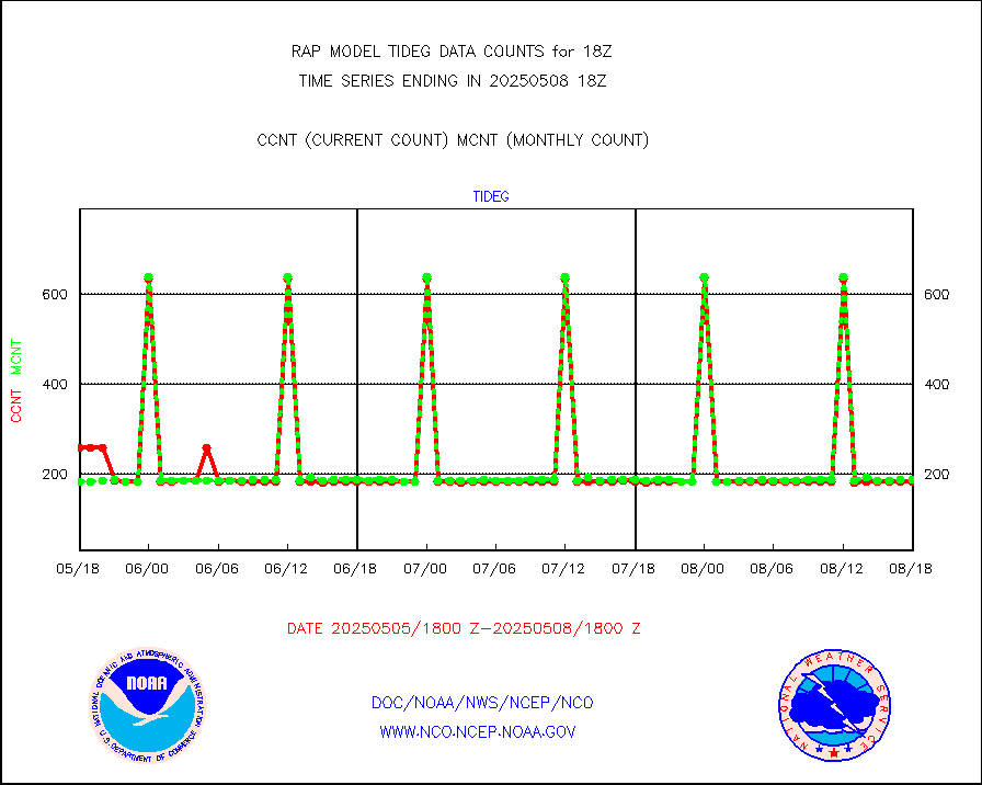
Tide gauge reports decoded from CREX format |
183 |
185 |
98.9 % |
0417.50-0418.50 |
||||||||||
| Data Types of Opportunity with Normal Counts | ||||||||||||||
|---|---|---|---|---|---|---|---|---|---|---|---|---|---|---|
| Type | Description | Hourly Count | Monthly Average | Percent (%) of Monthly Mean | UTC Time Window | |||||||||
GOES-16&up/NESDIS ir short-wv derived cld motion |
205 |
128 |
160.2 % |
0417.00-0417.99 |
||||||||||
MDCRS ACARS acft data (ARINC via AFWA)(AIREP fmt) |
0 |
0 |
n/a |
0414.75-0421.25 |
||||||||||
Manual AIREP aircraft data (dcded from AIREP fmt) |
2246 |
2531 |
88.7 % |
0414.75-0421.25 |
||||||||||
AQUA AIRS/AMSU-A/HSB brightness temps- every FOV |
0 |
0 |
n/a |
0415.00-0420.99 |
||||||||||
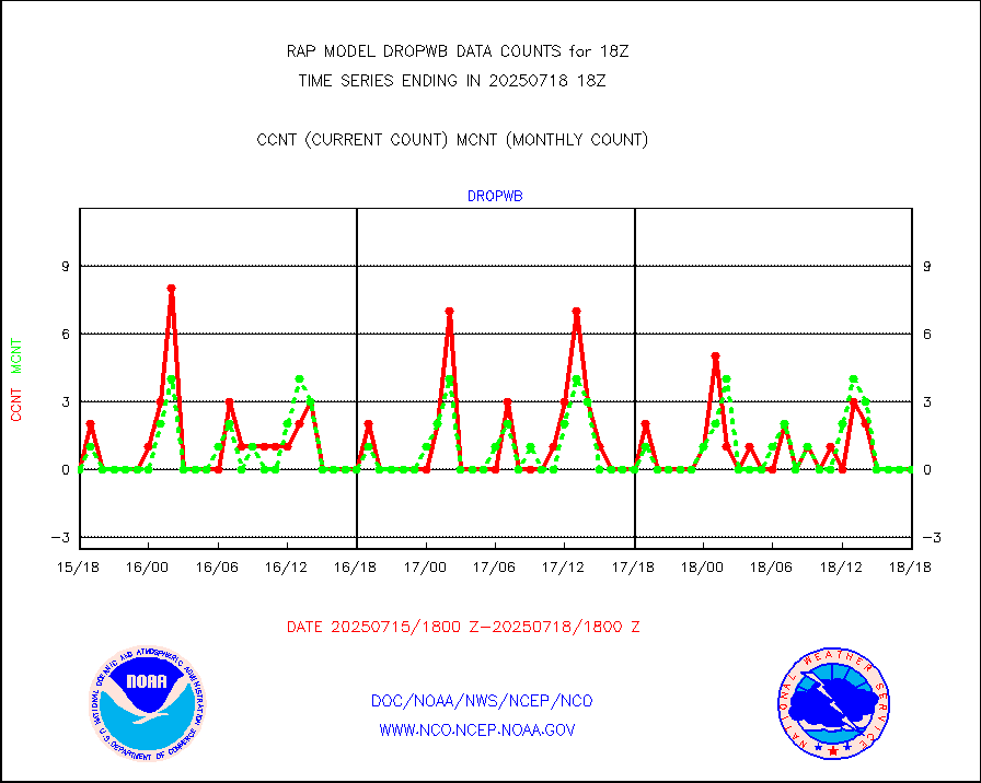
AMDAR aircraft data (decoded from AMDAR format) |
262 |
345 |
75.9 % |
0414.75-0421.25 |
||||||||||
AMDAR aircraft data (decoded from BUFR) |
7920 |
8313 |
95.3 % |
0414.75-0421.25 |
||||||||||
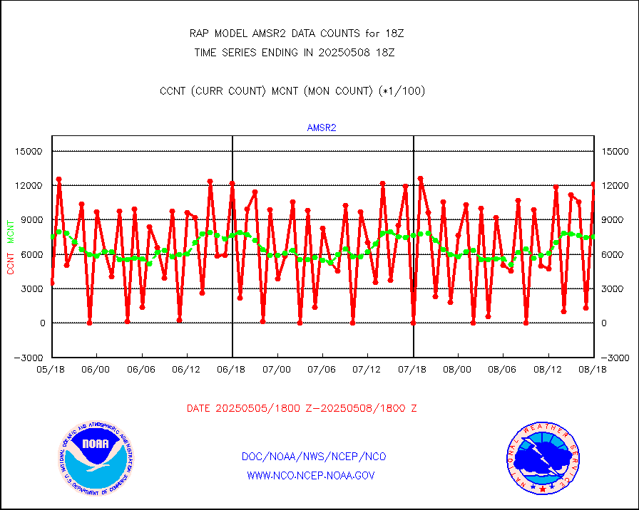
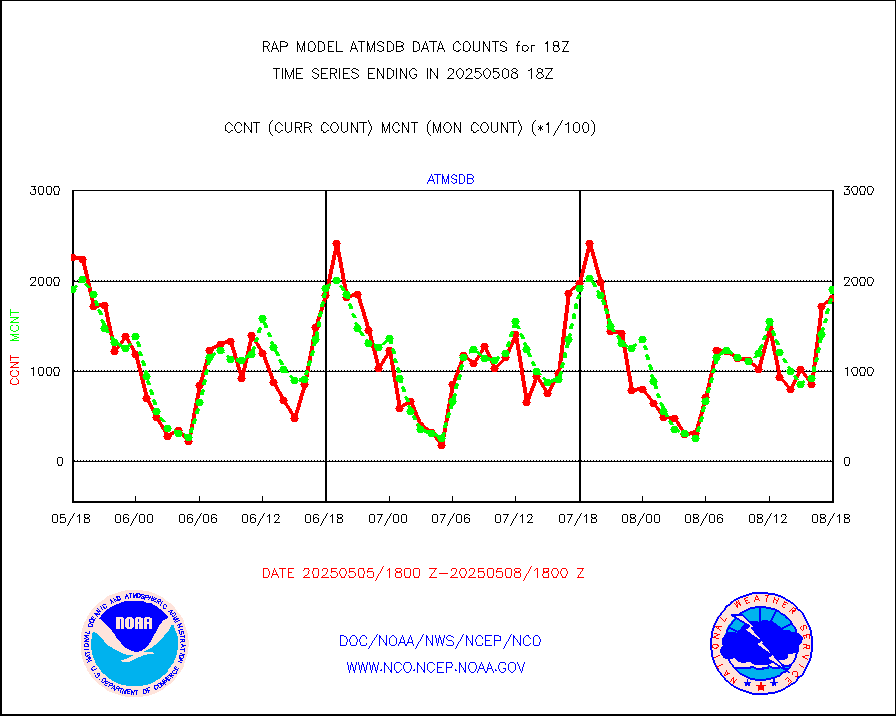
GCOM-W AMSR2 1B brightness temperatures |
1206610 |
729169 |
165.5 % |
0415.00-0415.99 |
||||||||||
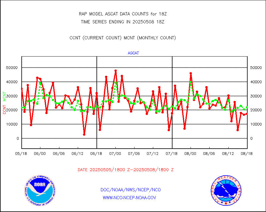
METOP 1-2 ASCAT products |
18005 |
21057 |
85.5 % |
0416.00-0420.00 |
||||||||||
NPP/NOAA-20 ATMS brightness temperatures |
159651 |
218110 |
73.2 % |
0416.00-0419.99 |
||||||||||
NPP/NOAA-20 ATMS bright. temps-direct b-cast SSEC |
122593 |
186915 |
65.6 % |
0416.00-0419.99 |
||||||||||
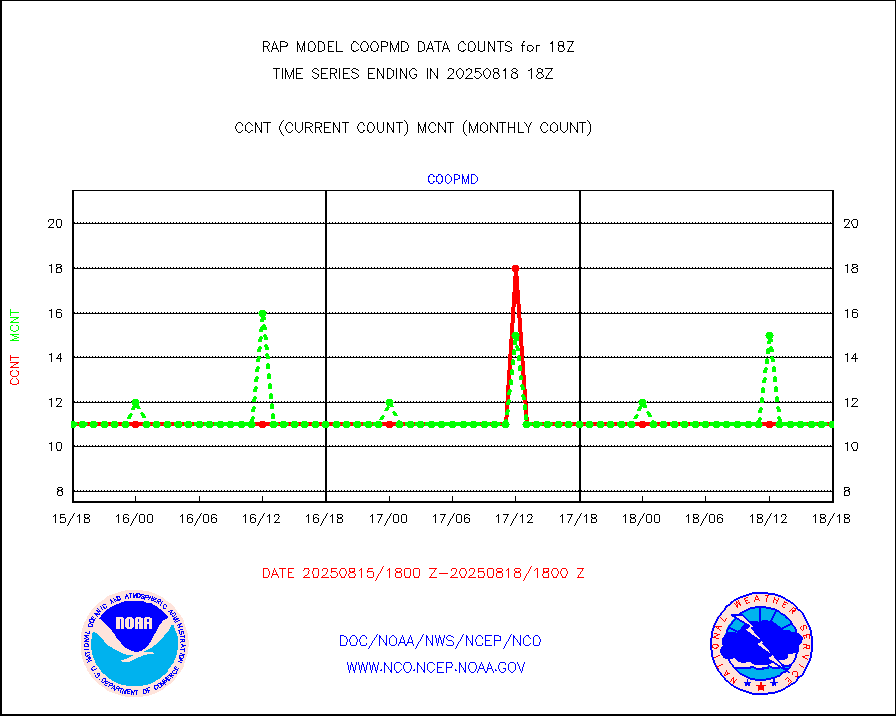
Coop/MADIS NEPP & HCN-Modernization NOAA COOP Obs |
11 |
11 |
100.0 % |
0417.50-0418.50 |
||||||||||
NPP/NOAA-20 CrIS full spctrl radn (431 ch subset) |
147152 |
117796 |
124.9 % |
0416.00-0419.99 |
||||||||||
NPP/NOAA-20 CrIS full spctrl radn dir brdcst SSEC |
69200 |
82034 |
84.4 % |
0416.00-0419.99 |
||||||||||
Coast Guard |
5 |
9 |
55.6 % |
0417.50-0418.50 |
||||||||||
Drifting buoys (decoded from BUFR) |
528 |
517 |
102.1 % |
0417.50-0418.50 |
||||||||||
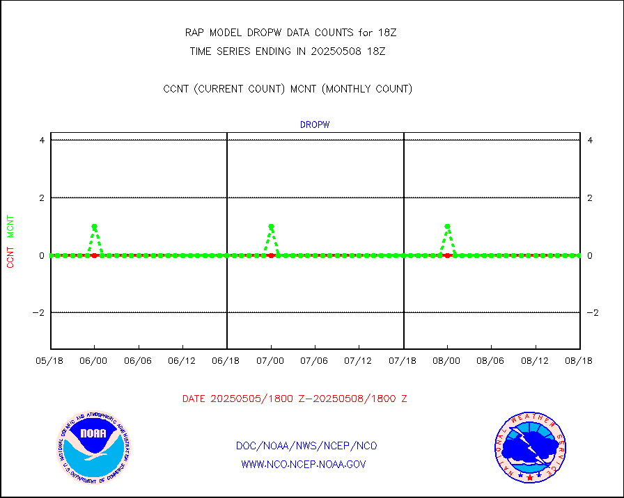
Dropwinsonde (from TEMP DROP) |
0 |
0 |
n/a |
0417.00-0419.00 |
||||||||||
Dropwinsonde (decoded from BUFR) |
0 |
0 |
n/a |
0417.00-0419.00 |
||||||||||
E-AMDAR (European AMDAR acft decoded from BUFR) |
12156 |
12053 |
100.9 % |
0414.75-0421.25 |
||||||||||
NOAA 15-19 & METOP 1-2 AMSU-A proc btmps frm RARS |
4920 |
7578 |
64.9 % |
0417.00-0419.00 |
||||||||||
NPP Adv. Tech. MW Sndr (ATMS) br. temps from RARS |
7898 |
8255 |
95.7 % |
0416.00-0419.99 |
||||||||||
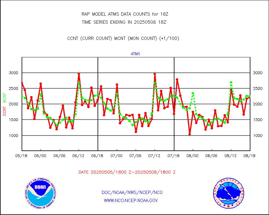
METOP 1-2 IASI 1C radiance data vbl chn from RARS |
49610 |
3163 |
n/a |
0416.00-0419.99 |
||||||||||
NOAA 18-19 & METOP 1-2 MHS proc. btemps from RARS |
57240 |
81274 |
70.4 % |
0417.00-0419.00 |
||||||||||
GPM GMI Level 1C-R brightness temperatures |
406311 |
266224 |
152.6 % |
0415.00-0420.99 |
||||||||||
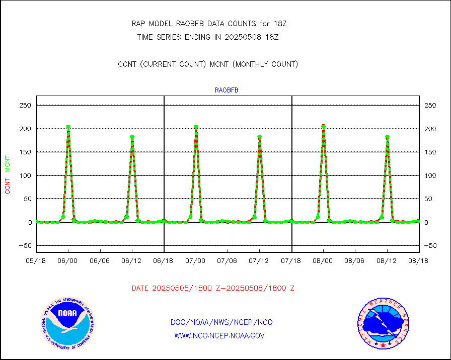
GPS radio occultation data |
118 |
116 |
101.7 % |
0416.00-0419.99 |
||||||||||
GOES-16/17 All Sky Radiances (proc.) |
812097 |
805985 |
100.8 % |
0416.00-0419.99 |
||||||||||
GOES-16/17 Clear Sky Radiances (proc.) |
407840 |
386946 |
105.4 % |
0416.00-0419.99 |
||||||||||
MTSAT/JMA water vapor imager derived cloud motion |
2427 |
2865 |
84.7 % |
0415.50-0420.50 |
||||||||||
GOES-16&up/NESDIS wv imgr/deep-lyr derivd cld mtn |
8809 |
7975 |
110.5 % |
0417.00-0417.99 |
||||||||||
METEOSAT/EUMETSAT wvpr imgr drv cld motion NBseq |
5691 |
5539 |
102.7 % |
0416.50-0419.49 |
||||||||||
GOES-16&up/NESDIS wv imgr/cld-top derived cld mtn |
13778 |
13750 |
100.2 % |
0417.00-0417.99 |
||||||||||
METOP 1-2 IASI 1C radiances-direct broadcast SSEC |
49775 |
71418 |
69.7 % |
0416.00-0419.99 |
||||||||||
METEOSAT/EUMETSAT ir lg-wave drv cld motion NBseq |
3144 |
3122 |
100.7 % |
0416.50-0419.49 |
||||||||||
VIIRS (NPP/NOAA-20) ir lg-wv drv cloud motion(NB) |
0 |
0 |
n/a |
0415.50-0420.50 |
||||||||||
AVHRR (NOAA/METOP) ir lg-wave derived cld motion |
0 |
0 |
n/a |
0415.50-0420.50 |
||||||||||
AVHRR (METOP) ir lg-wave derived cld motion |
0 |
0 |
n/a |
0416.50-0419.49 |
||||||||||
MTSAT/JMA infrared long-wave derived cloud motion |
1755 |
2326 |
75.5 % |
0415.50-0420.50 |
||||||||||
GOES-16&up/NESDIS ir long-wave derived cld motion |
32777 |
31358 |
104.5 % |
0417.00-0417.99 |
||||||||||
Korean AMDAR aircraft data (decoded from BUFR) |
0 |
0 |
n/a |
0414.75-0421.25 |
||||||||||
Land-based CMAN stations decoded from CMAN format |
45 |
42 |
107.1 % |
0417.50-0418.50 |
||||||||||
LLDN Long-rng lightning from Vaisala via NOAAPORT |
114739 |
134145 |
85.5 % |
0417.00-0418.50 |
||||||||||
NLDN Shrt-rng lightning from Vaisala via NOAAPORT |
5408 |
7232 |
74.8 % |
0417.00-0418.50 |
||||||||||
Moored buoys (decoded from BUFR) |
563 |
604 |
93.2 % |
0417.50-0418.50 |
||||||||||
Mesonet/MADIS Colorado E-470 (Interstate 470) |
24 |
24 |
100.0 % |
0417.50-0418.50 |
||||||||||
Mesonet/MADIS Alaska Department of Transportation |
118 |
84 |
140.5 % |
0417.50-0418.50 |
||||||||||
Mesonet/MADIS U.S. Army Aberdeen Proving Grounds |
0 |
0 |
n/a |
0417.50-0418.50 |
||||||||||
Mesonet/MADIS Citizen Weather Observers Program |
60032 |
59555 |
100.8 % |
0417.50-0418.50 |
||||||||||
Mesonet/MADIS AWS Convergence Technologies, Inc. |
23412 |
20625 |
113.5 % |
0417.50-0418.50 |
||||||||||
Mesonet/MADIS "Anything Weather" |
0 |
0 |
n/a |
0417.50-0418.50 |
||||||||||
Mesonet/MADIS Colorado Dept. of Transportation |
0 |
0 |
n/a |
0417.50-0418.50 |
||||||||||
Mesonet/MADIS DC Net |
0 |
0 |
n/a |
0417.50-0418.50 |
||||||||||
Mesonet/MADIS Denver Urban Drainage & Flood Cntrl |
0 |
0 |
n/a |
0417.50-0418.50 |
||||||||||
Mesonet/MADIS Florida (FAWN & USF) |
4 |
3 |
133.3 % |
0417.50-0418.50 |
||||||||||
Mesonet/MADIS Florida Dept. of Transportation |
0 |
0 |
n/a |
0417.50-0418.50 |
||||||||||
Mesonet/MADIS Georgia Dept. of Transportation |
0 |
0 |
n/a |
0417.50-0418.50 |
||||||||||
Mesonet/MADIS NWS Hydromet Auto Data System(HADS) |
5414 |
4624 |
117.1 % |
0417.50-0418.50 |
||||||||||
Mesonet/MADIS Iowa Environmental |
159 |
158 |
100.6 % |
0417.50-0418.50 |
||||||||||
Mesonet/MADIS Indiana Dept. of Transportation |
0 |
0 |
n/a |
0417.50-0418.50 |
||||||||||
Mesonet/MADIS Iowa Department of Transportation |
0 |
0 |
n/a |
0417.50-0418.50 |
||||||||||
Mesonet/MADIS Kansas Department of Transportation |
331 |
317 |
104.4 % |
0417.50-0418.50 |
||||||||||
Mesonet/MADIS Oklahoma Mesonet |
527 |
553 |
95.3 % |
0417.50-0418.50 |
||||||||||
Mesonet/MADIS Louisiana State/Jackson State Univ. |
0 |
0 |
n/a |
0417.50-0418.50 |
||||||||||
Mesonet/MADIS Missouri Commercial Agricult Wx Net |
272 |
279 |
97.5 % |
0417.50-0418.50 |
||||||||||
Mesonet/MADIS Minnesota Dept. of Transportation |
0 |
0 |
n/a |
0417.50-0418.50 |
||||||||||
Mesonet/MADIS NOS-Phys Oceanographic Realtime Sys |
292 |
263 |
111.0 % |
0417.50-0418.50 |
||||||||||
Mesonet/MADIS NFIC Remote Automated Wx Stns(RAWS) |
1682 |
1358 |
123.9 % |
0417.50-0418.50 |
||||||||||
Mesonet/MADIS many providers, not separated out |
42509 |
40470 |
105.0 % |
0417.50-0418.50 |
||||||||||
Mesonet/MADIS UrbaNet |
3299 |
2993 |
110.2 % |
0417.50-0418.50 |
||||||||||
Mesonet/MADIS Virginia Dept. of Transportation |
0 |
0 |
n/a |
0417.50-0418.50 |
||||||||||
Mesonet/MADIS "Weather for You" |
0 |
0 |
n/a |
0417.50-0418.50 |
||||||||||
Mesonet/MADIS Wisconsin Dept. of Transportation |
0 |
0 |
n/a |
0417.50-0418.50 |
||||||||||
Mesonet/MADIS MesoWest (many subproviders) |
39131 |
37585 |
104.1 % |
0417.50-0418.50 |
||||||||||
Mesonet/MADIS West Texas |
5202 |
5087 |
102.3 % |
0417.50-0418.50 |
||||||||||
METOP 1-2 IASI 1C radiance data (varbl. channels) |
23739 |
20867 |
113.8 % |
0416.00-0419.99 |
||||||||||
NEXRAD Vel Azm Dsp(VAD) winds via Level 2 decoder |
734 |
655 |
112.1 % |
0417.00-0419.00 |
||||||||||
NOAA 16-19 Solar Backscatter UV-2 rad frm V8 BUFR |
0 |
0 |
n/a |
0416.00-0418.99 |
||||||||||
PIBAL (from PILOT, PILOT SHIP, PILOT MOBIL) |
0 |
0 |
n/a |
0417.00-0419.00 |
||||||||||
PIBAL (decoded from BUFR) |
0 |
0 |
n/a |
0417.00-0419.00 |
||||||||||
Manual PIREP aircraft data (dcded from AIREP fmt) |
527 |
533 |
98.9 % |
0414.75-0421.25 |
||||||||||
Profilr winds from PIBAL (PILOT,PILOT SHIP/MOBIL) |
0 |
0 |
n/a |
0416.50-0419.50 |
||||||||||
Rawinsonde - fixed land (decoded from BUFR) |
10 |
7 |
142.9 % |
0417.00-0419.00 |
||||||||||
Rawinsonde - mobile land (from TEMP/PILOT MOBIL) |
0 |
0 |
n/a |
0417.00-0419.00 |
||||||||||
Rawinsonde - mobile land (decoded from BUFR) |
0 |
0 |
n/a |
0417.00-0419.00 |
||||||||||
Rawinsonde - ship (from TEMP SHIP, PILOT SHIP) |
0 |
0 |
n/a |
0417.00-0419.00 |
||||||||||
Rawinsonde - ship (decoded from BUFR) |
0 |
0 |
n/a |
0417.00-0419.00 |
||||||||||
NEXRAD radial wind (Level 2 - GTS) |
1224975 |
1074210 |
114.0 % |
0417.50-0418.49 |
||||||||||
Flight level reconnaissance aircraft data |
2 |
0 |
n/a |
0417.00-0419.00 |
||||||||||
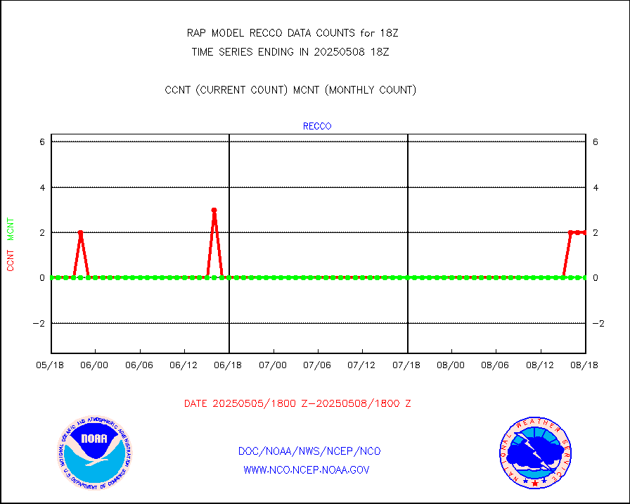
Surface Marine Saildrone (decoded from BUFR) |
2 |
2 |
100.0 % |
0416.00-0419.99 |
||||||||||
Megha-Tropiques SAPHIR L1A2 brightness temps |
0 |
0 |
n/a |
0415.00-0420.99 |
||||||||||
METEOSAT-10 2nd Gen SEVIRI All Sky Radiance(proc) |
9512 |
9174 |
103.7 % |
0416.00-0419.99 |
||||||||||
METEOSAT-10 2nd Gen SEVIRI Clr Sky Radiance(proc) |
0 |
0 |
n/a |
0416.00-0419.99 |
||||||||||
Ship - manual and automatic, restricted |
4 |
16 |
25.0 % |
0417.50-0418.50 |
||||||||||
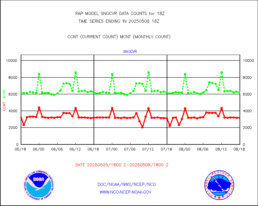
NOW COVER, DEPTH/DENSITY AND WATER EQUIVALENT |
3152 |
6169 |
51.1 % |
0416.00-0420.00 |
||||||||||
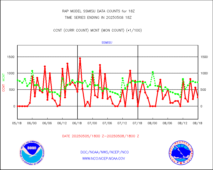
DMSP SSM/IS 1C radiance data (Unified Pre-Proc.) |
0 |
55249 |
0.0 % |
0416.00-0419.99 |
||||||||||
Sub-surface float and glider profile (BUFR) |
2 |
1 |
200.0 % |
0416.00-0419.99 |
||||||||||
Synoptic - restricted (WMO Res 40) manual & auto. |
0 |
0 |
n/a |
0417.50-0418.50 |
||||||||||
Synoptic - restricted (WMO Res 40)(decoded BUFR) |
247 |
288 |
85.8 % |
0417.50-0418.50 |
||||||||||
Synoptic - mobile manual & auto (decoded fr BUFR) |
0 |
0 |
n/a |
0417.50-0418.50 |
||||||||||
TAMDAR aircft data-all types(from Panasonic,BUFR) |
203 |
207 |
98.1 % |
0414.75-0421.25 |
||||||||||
MTSAT/JMA visible derived cloud motion |
62 |
144 |
43.1 % |
0415.50-0420.50 |
||||||||||
GOES-16&up/NESDIS visible derived cloud motion |
198729 |
188776 |
105.3 % |
0417.00-0417.99 |
||||||||||
METEOSAT/EUMETSAT visible drv cld motion NBseq |
6650 |
6721 |
98.9 % |
0416.50-0419.49 |
||||||||||


