| Suspect Data Shortages in Critical Types - Monitor | ||||||||||||||
|---|---|---|---|---|---|---|---|---|---|---|---|---|---|---|
| Type | Description | Hourly Count | Monthly Average | Percent (%) of Monthly Mean | ||||||||||
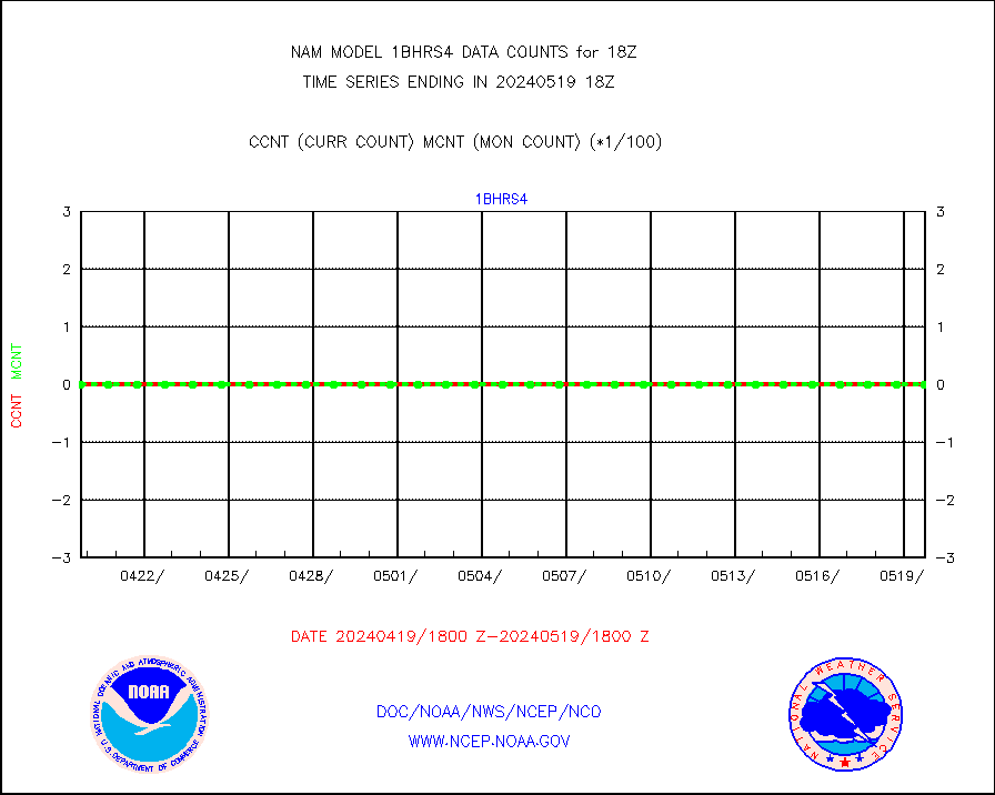
NOAA 18-19 & METOP 1-2 HIRS-4 NCEP-proc. br.temps |
0 |
177 |
0.0 % |
|||||||||||
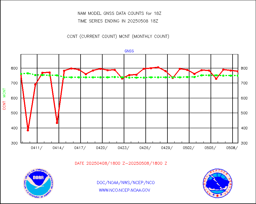
Grnd-based Gbl Navigation Sat System (GNSS) data |
229 |
627 |
36.5 % |
|||||||||||
Mesonet/MADIS AWS Convergence Technologies, Inc. |
10828 |
46446 |
23.3 % |
|||||||||||
| Suspect Excess in Critical Types - Monitor | ||||||||||||||
|---|---|---|---|---|---|---|---|---|---|---|---|---|---|---|
| Type | Description | Hourly Count | Monthly Average | Percent (%) of Monthly Mean | ||||||||||
NOAA 15-19 & METOP 1-2 AMSU-A NCEP-proc. br.temps |
9443 |
4353 |
216.9 % |
|||||||||||
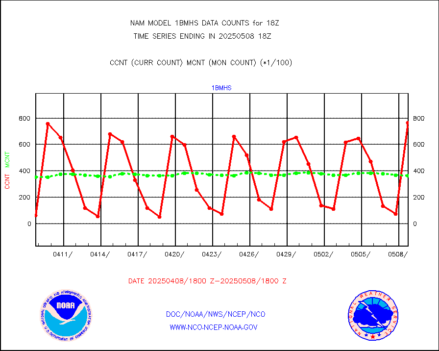
NOAA 18-19 & METOP 1-2 MHS NCEP-proces. br. temps |
84090 |
38048 |
221.0 % |
|||||||||||
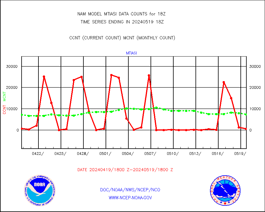
METOP 1-2 IASI 1C radiance data (varbl. channels) |
27670 |
11732 |
235.9 % |
|||||||||||
| Shortage in Data Type of Opportunity - Monitor | ||||||||||||||
|---|---|---|---|---|---|---|---|---|---|---|---|---|---|---|
| Type | Description | Hourly Count | Monthly Average | Percent (%) of Monthly Mean | ||||||||||
NOAA 15-19 & METOP 1-2 HIRS-3/4 pr btmps frm RARS |
0 |
7488 |
0.0 % |
|||||||||||
| Critical Data with Normal Counts | ||||||||||||||
|---|---|---|---|---|---|---|---|---|---|---|---|---|---|---|
| Type | Description | Hourly Count | Monthly Average | Percent (%) of Monthly Mean | ||||||||||
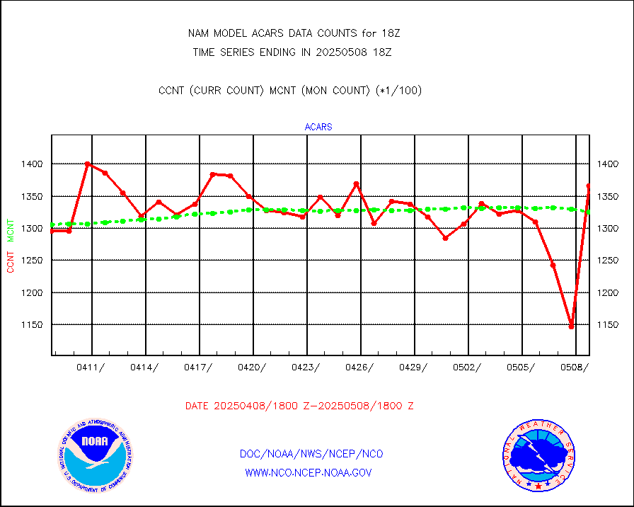
MDCRS ACARS acft data from ARINC(dcded from BUFR) |
148629 |
139668 |
106.4 % |
|||||||||||
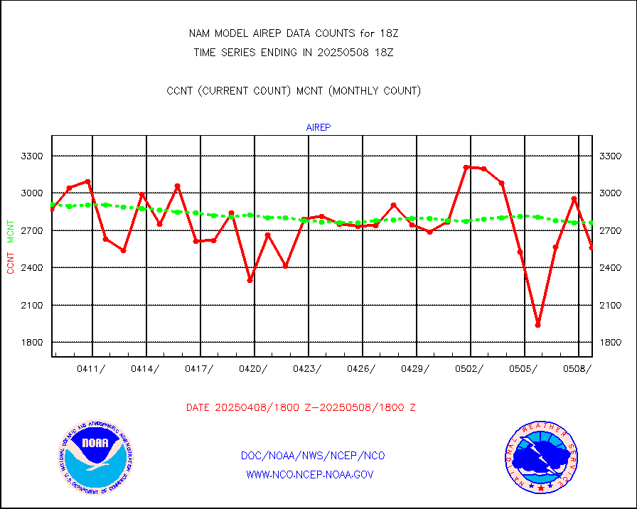
Manual AIREP aircraft data (dcded from AIREP fmt) |
3304 |
2996 |
110.3 % |
|||||||||||
AQUA AIRS/AMSU-A/HSB brightness temps- every FOV |
0 |
0 |
n/a |
|||||||||||
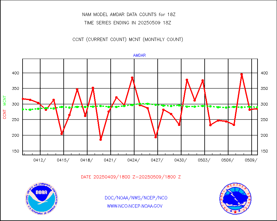
AMDAR aircraft data (decoded from AMDAR format) |
275 |
342 |
80.4 % |
|||||||||||
AMDAR aircraft data (decoded from BUFR) |
9245 |
9391 |
98.4 % |
|||||||||||
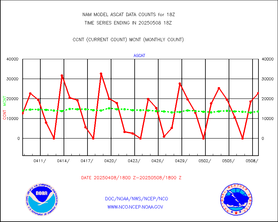
METOP 1-2 ASCAT products |
25733 |
14395 |
178.8 % |
|||||||||||
Canadian AMDAR aircraft data (decoded from BUFR) |
0 |
0 |
n/a |
|||||||||||
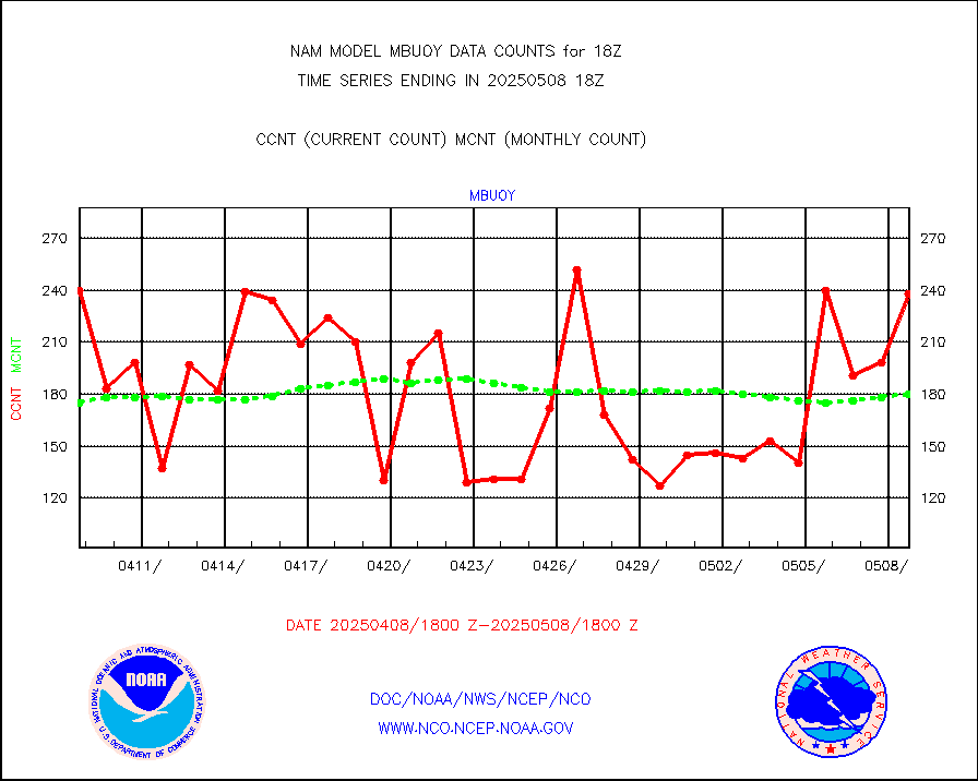
Surface Marine CMAN rpts decoded from BUFR format |
5691 |
5726 |
99.4 % |
|||||||||||
Buoys decoded from FM-18 fmt (moored or drifting) |
1 |
4 |
25.0 % |
|||||||||||
Dropwinsonde (from TEMP DROP) |
0 |
0 |
n/a |
|||||||||||
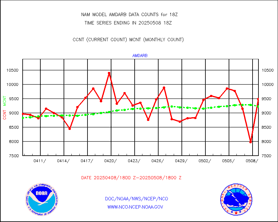
E-AMDAR (European AMDAR acft decoded from BUFR) |
14325 |
15491 |
92.5 % |
|||||||||||
GOES/NESDIS hi-resol. (1x1 f-o-v) sndgs/radiances |
0 |
0 |
n/a |
|||||||||||
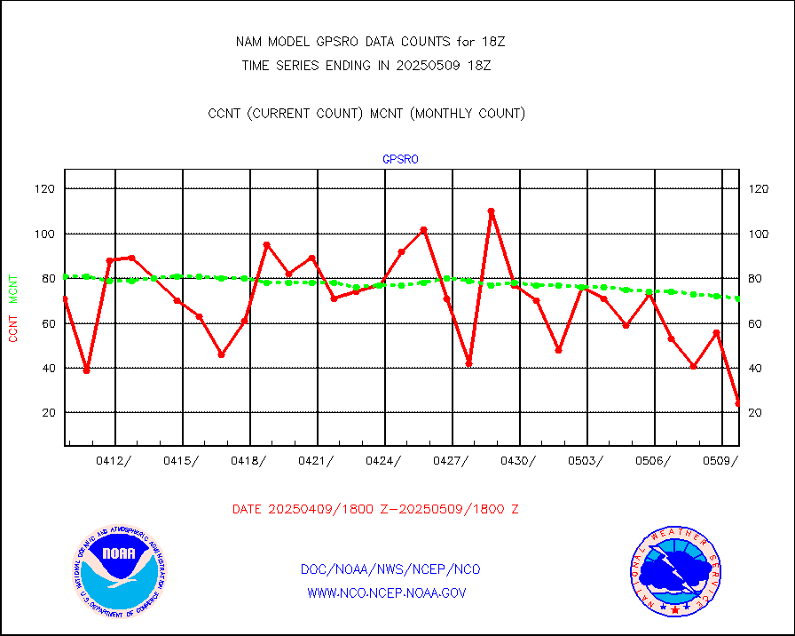
GPS radio occultation data |
85 |
85 |
100.0 % |
|||||||||||
MODIS (AQUA/TERRA) wvpr imager derived cld motion |
0 |
0 |
n/a |
|||||||||||
MODIS (AQUA/TERRA) ir l-wave derived cloud motion |
0 |
0 |
n/a |
|||||||||||
Land-based CMAN stations decoded from CMAN format |
225 |
176 |
127.8 % |
|||||||||||
Buoys decoded from FM-13 format (moored) |
288 |
220 |
130.9 % |
|||||||||||
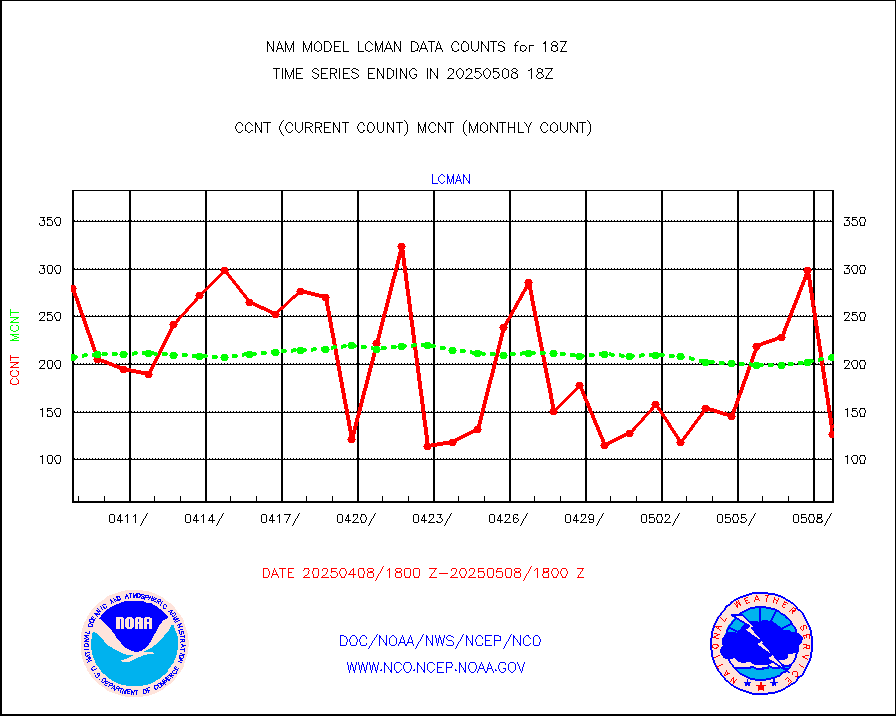
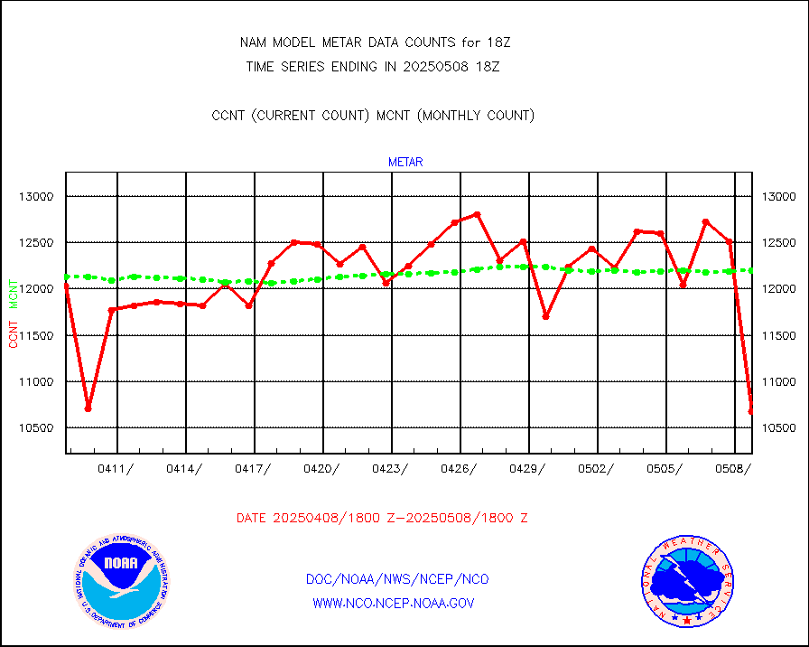
Aviation - METAR |
12531 |
12221 |
102.5 % |
|||||||||||
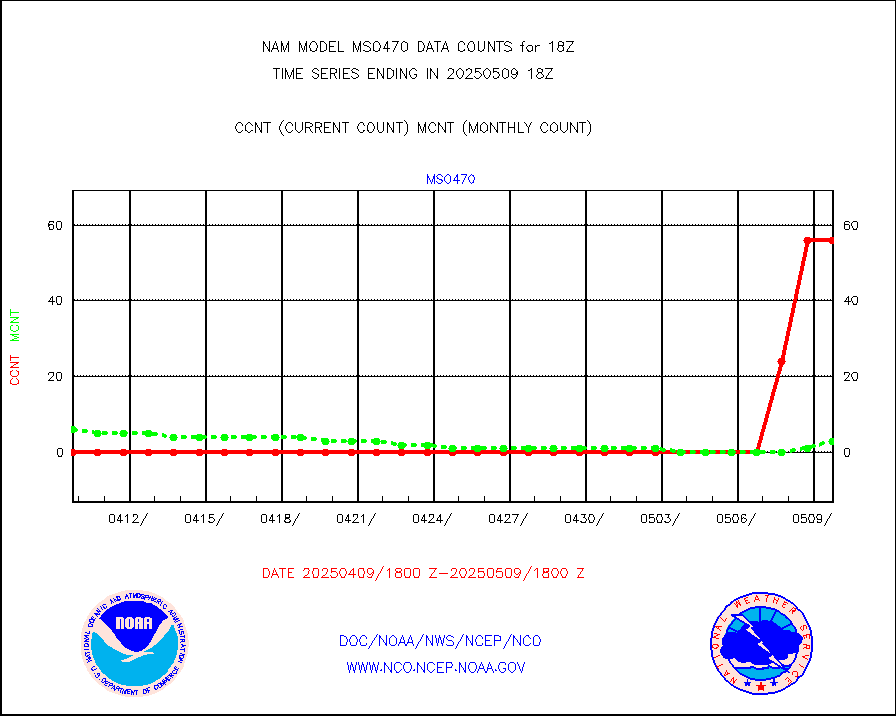
Mesonet/MADIS Colorado E-470 (Interstate 470) |
56 |
55 |
101.8 % |
|||||||||||
Mesonet/MADIS Alaska Department of Transportation |
417 |
374 |
111.5 % |
|||||||||||
Mesonet/MADIS U.S. Army Aberdeen Proving Grounds |
0 |
0 |
n/a |
|||||||||||
Mesonet/MADIS Citizen Weather Observers Program |
81068 |
126976 |
63.8 % |
|||||||||||
Mesonet/MADIS "Anything Weather" |
0 |
0 |
n/a |
|||||||||||
Mesonet/MADIS Colorado Dept. of Transportation |
0 |
0 |
n/a |
|||||||||||
Mesonet/MADIS DC Net |
0 |
0 |
n/a |
|||||||||||
Mesonet/MADIS Denver Urban Drainage & Flood Cntrl |
0 |
0 |
n/a |
|||||||||||
Mesonet/MADIS Florida (FAWN & USF) |
8 |
8 |
100.0 % |
|||||||||||
Mesonet/MADIS Florida Dept. of Transportation |
0 |
0 |
n/a |
|||||||||||
Mesonet/MADIS Georgia Dept. of Transportation |
0 |
0 |
n/a |
|||||||||||
Mesonet/MADIS NWS Hydromet Auto Data System(HADS) |
17321 |
17578 |
98.5 % |
|||||||||||
Mesonet/MADIS Iowa Environmental |
419 |
409 |
102.4 % |
|||||||||||
Mesonet/MADIS Indiana Dept. of Transportation |
0 |
0 |
n/a |
|||||||||||
Mesonet/MADIS Iowa Department of Transportation |
0 |
0 |
n/a |
|||||||||||
Mesonet/MADIS Kansas Department of Transportation |
861 |
848 |
101.5 % |
|||||||||||
Mesonet/MADIS Oklahoma Mesonet |
1470 |
1414 |
104.0 % |
|||||||||||
Mesonet/MADIS Louisiana State/Jackson State Univ. |
0 |
0 |
n/a |
|||||||||||
Mesonet/MADIS Missouri Commercial Agricult Wx Net |
716 |
699 |
102.4 % |
|||||||||||
Mesonet/MADIS Minnesota Dept. of Transportation |
0 |
0 |
n/a |
|||||||||||
Mesonet/MADIS NOS-Phys Oceanographic Realtime Sys |
804 |
797 |
100.9 % |
|||||||||||
Mesonet/MADIS NFIC Remote Automated Wx Stns(RAWS) |
3581 |
3923 |
91.3 % |
|||||||||||
Mesonet/MADIS many providers, not separated out |
62243 |
97321 |
64.0 % |
|||||||||||
Mesonet/MADIS Virginia Dept. of Transportation |
0 |
0 |
n/a |
|||||||||||
Mesonet/MADIS "Weather for You" |
0 |
0 |
n/a |
|||||||||||
Mesonet/MADIS Wisconsin Dept. of Transportation |
0 |
0 |
n/a |
|||||||||||
Mesonet/MADIS MesoWest (many subproviders) |
57463 |
92231 |
62.3 % |
|||||||||||
Mesonet/MADIS West Texas |
13155 |
13239 |
99.4 % |
|||||||||||
NEXRAD Vel Azm Dsp(VAD) winds via radar coded msg |
0 |
0 |
n/a |
|||||||||||
PIBAL (from PILOT, PILOT SHIP, PILOT MOBIL) |
0 |
0 |
n/a |
|||||||||||
Multi-Agency Profiler (MAP) and SODAR winds |
210 |
188 |
111.7 % |
|||||||||||
Profilr winds from PIBAL (PILOT,PILOT SHIP/MOBIL) |
0 |
0 |
n/a |
|||||||||||
Rawinsonde - fixed land (from TEMP or PILOT) |
20 |
14 |
142.9 % |
|||||||||||
Rawinsonde - mobile land (from TEMP/PILOT MOBIL) |
0 |
0 |
n/a |
|||||||||||
Rawinsonde - ship (from TEMP SHIP, PILOT SHIP) |
0 |
0 |
n/a |
|||||||||||
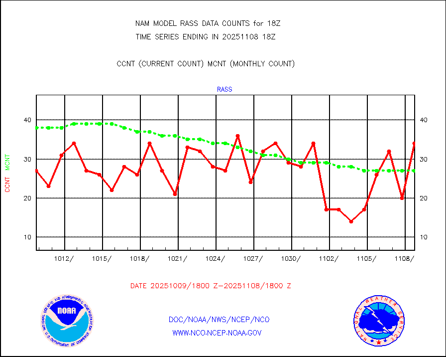
RASS temperatures (NOAA and Multi-Agency) |
63 |
49 |
128.6 % |
|||||||||||
Flight level reconnaissance aircraft data |
0 |
0 |
n/a |
|||||||||||
Ship - manual and automatic, restricted |
41 |
57 |
71.9 % |
|||||||||||
Ship - manual and automatic, restricted (BUFR) |
137 |
139 |
98.6 % |
|||||||||||
Ship - manual and automatic, unrestricted |
192 |
198 |
97.0 % |
|||||||||||
Ship - manual and automatic, unrestricted (BUFR) |
1604 |
1593 |
100.7 % |
|||||||||||
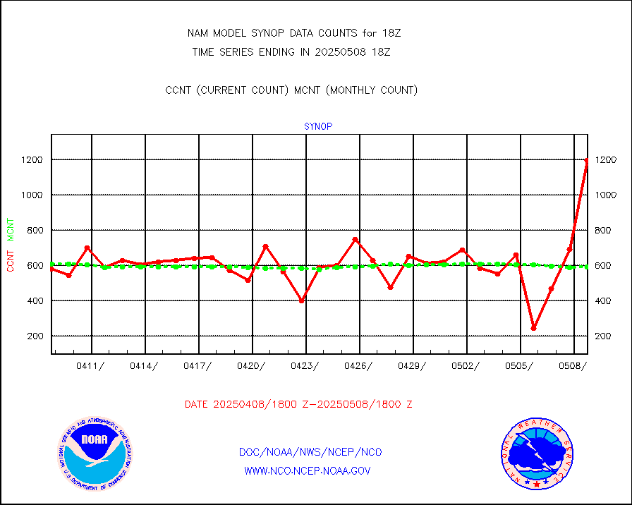
Synoptic - fixed manual & auto (decoded fr BUFR) |
4481 |
4770 |
93.9 % |
|||||||||||
Synoptic - restricted (WMO Res 40) manual & auto. |
0 |
0 |
n/a |
|||||||||||
Synoptic - restricted (WMO Res 40)(decoded BUFR) |
591 |
633 |
93.4 % |
|||||||||||
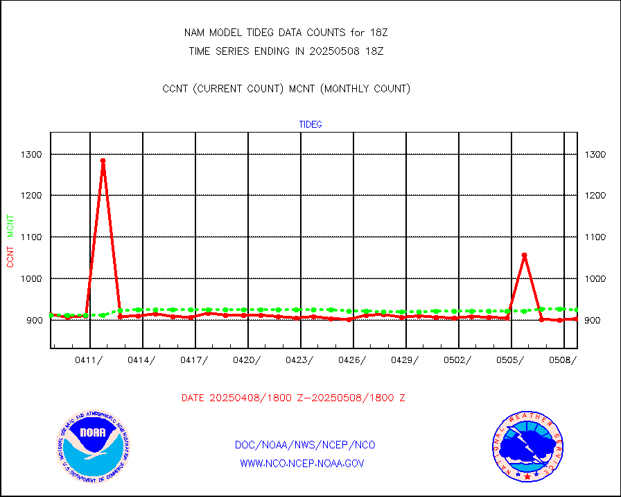
Tide gauge reports decoded from CREX format |
914 |
916 |
99.8 % |
|||||||||||
| Data Types of Opportunity with Normal Counts | ||||||||||||||
|---|---|---|---|---|---|---|---|---|---|---|---|---|---|---|
| Type | Description | Hourly Count | Monthly Average | Percent (%) of Monthly Mean | ||||||||||
MDCRS ACARS acft data (ARINC via AFWA)(AIREP fmt) |
0 |
0 |
n/a |
|||||||||||
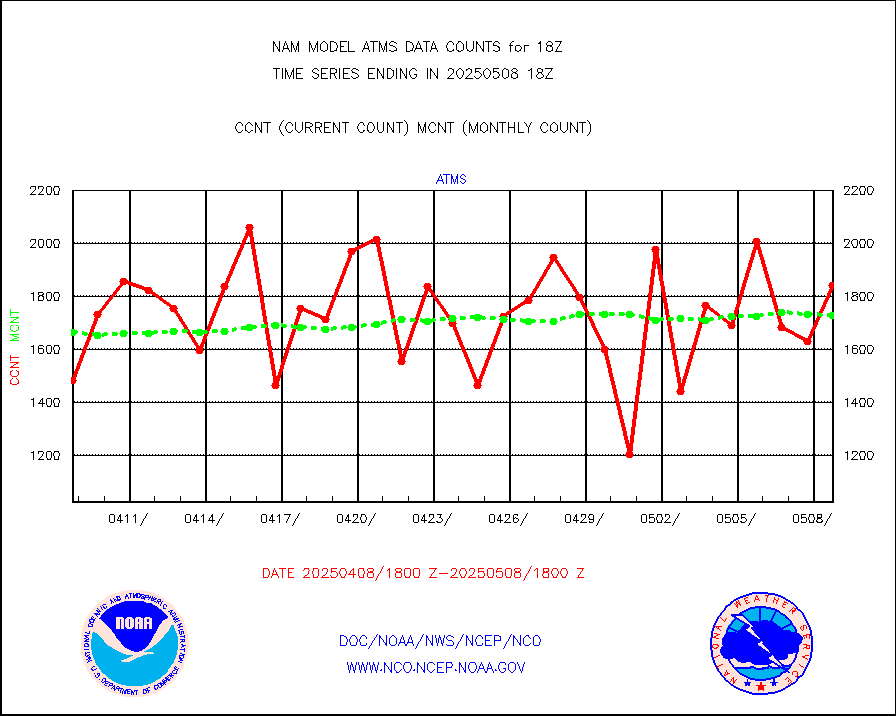
NPP/NOAA-20 ATMS brightness temperatures |
197147 |
163550 |
120.5 % |
|||||||||||
NPP CrIS apodized radiances (399 channel) |
0 |
0 |
n/a |
|||||||||||
Coast Guard |
17 |
16 |
106.2 % |
|||||||||||
Drifting buoys (decoded from BUFR) |
698 |
688 |
101.5 % |
|||||||||||
NOAA 15-19 & METOP 1-2 AMSU-A proc btmps frm RARS |
11960 |
13783 |
86.8 % |
|||||||||||
NOAA 18-19 & METOP 1-2 MHS proc. btemps from RARS |
130260 |
143885 |
90.5 % |
|||||||||||
GOES/NESDIS hi-resol. (1x1 f-o-v) cloud data |
0 |
0 |
n/a |
|||||||||||
MTSAT/JMA water vapor imager derived cloud motion |
1081 |
1498 |
72.2 % |
|||||||||||
METEOSAT/EUMETSAT wvpr imgr drv cld motion NBseq |
5433 |
5742 |
94.6 % |
|||||||||||
METEOSAT/EUMETSAT ir lg-wave drv cld motion NBseq |
3112 |
3241 |
96.0 % |
|||||||||||
VIIRS (NPP/NOAA-20) ir lg-wv drv cloud motion(NB) |
0 |
0 |
n/a |
|||||||||||
AVHRR (NOAA/METOP) ir lg-wave derived cld motion |
0 |
0 |
n/a |
|||||||||||
AVHRR (METOP) ir lg-wave derived cld motion |
0 |
0 |
n/a |
|||||||||||
MTSAT/JMA infrared long-wave derived cloud motion |
1106 |
1202 |
92.0 % |
|||||||||||
Korean AMDAR aircraft data (decoded from BUFR) |
0 |
0 |
n/a |
|||||||||||
GOES/NASA(Langley) hi-res. (1x1 f-o-v) cloud data |
9999999 |
9723088 |
102.8 % |
|||||||||||
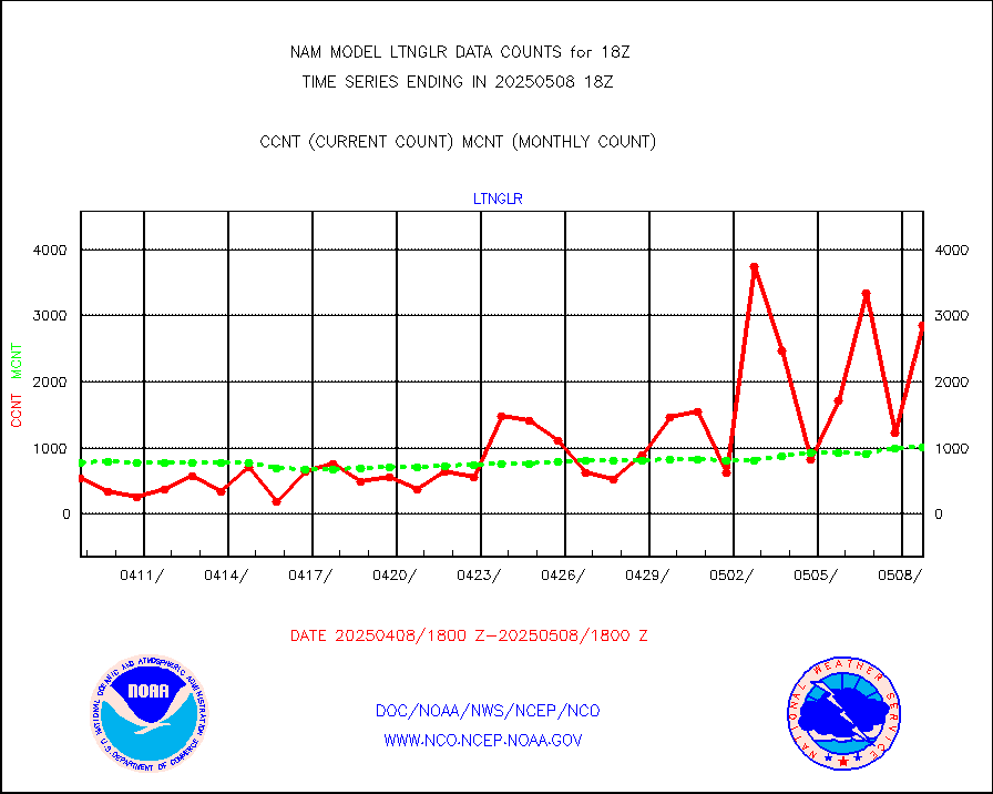
LLDN Long-rng lightning from Vaisala via NOAAPORT |
291194 |
227363 |
128.1 % |
|||||||||||
NLDN Shrt-rng lightning from Vaisala via NOAAPORT |
14257 |
12321 |
115.7 % |
|||||||||||
Moored buoys (decoded from BUFR) |
1558 |
1608 |
96.9 % |
|||||||||||
NEXRAD Vel Azm Dsp(VAD) winds via Level 2 decoder |
1099 |
1118 |
98.3 % |
|||||||||||
NOAA 16-19 Solar Backscatter UV-2 rad frm V8 BUFR |
0 |
0 |
n/a |
|||||||||||
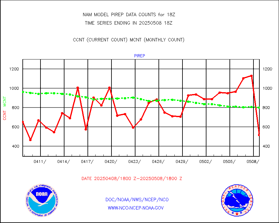
Manual PIREP aircraft data (dcded from AIREP fmt) |
704 |
672 |
104.8 % |
|||||||||||
NEXRAD reflectivity (Lvl 2 - GTS) |
10361415 |
9123088 |
113.6 % |
|||||||||||
NEXRAD radial wind (Level 2 - GTS) |
3627915 |
3268810 |
111.0 % |
|||||||||||
METEOSAT-10 2nd Gen SEVIRI Clr Sky Radiance(proc) |
0 |
0 |
n/a |
|||||||||||
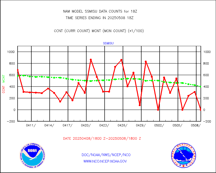
DMSP SSM/IS 1C radiance data (Unified Pre-Proc.) |
25583 |
27429 |
93.3 % |
|||||||||||
Synoptic - fixed manual and automatic |
579 |
630 |
91.9 % |
|||||||||||
Synoptic - mobile manual & auto (decoded fr BUFR) |
27 |
27 |
100.0 % |
|||||||||||
TAMDAR aircft data-all types(from Panasonic,BUFR) |
191 |
256 |
74.6 % |
|||||||||||
MTSAT/JMA visible derived cloud motion |
781 |
699 |
111.7 % |
|||||||||||
METEOSAT/EUMETSAT visible drv cld motion NBseq |
8174 |
6912 |
118.3 % |
|||||||||||


