| Suspect Data Shortages in Critical Types - Monitor | ||||||||||||||
|---|---|---|---|---|---|---|---|---|---|---|---|---|---|---|
| Type | Description | Hourly Count | Monthly Average | Percent (%) of Monthly Mean | ||||||||||
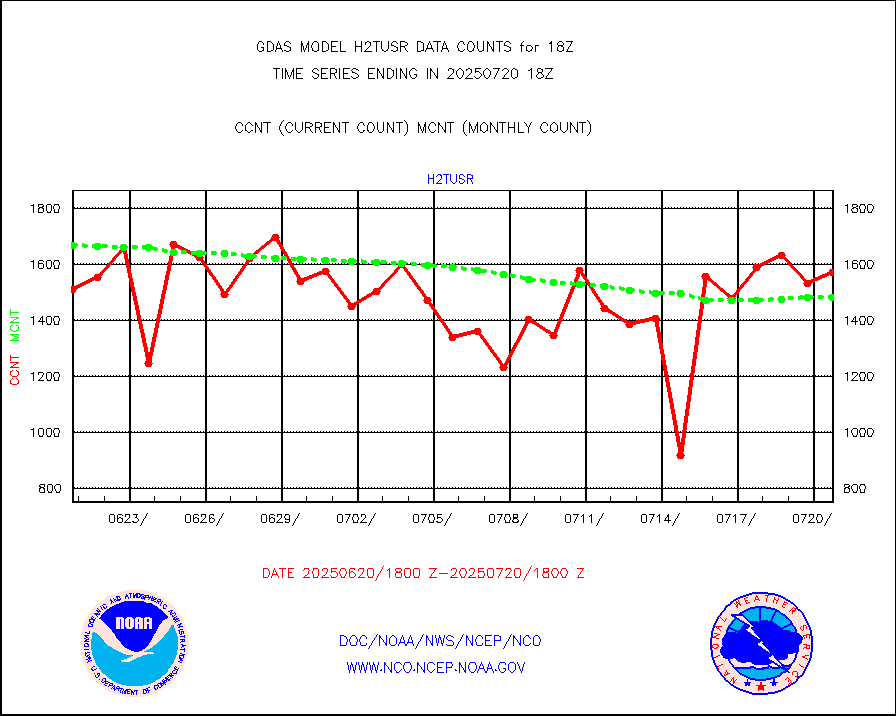
NOAA 18-19 & METOP 1-2 HIRS-4 NCEP-proc. br.temps |
0 |
97925 |
0.0 % |
|||||||||||
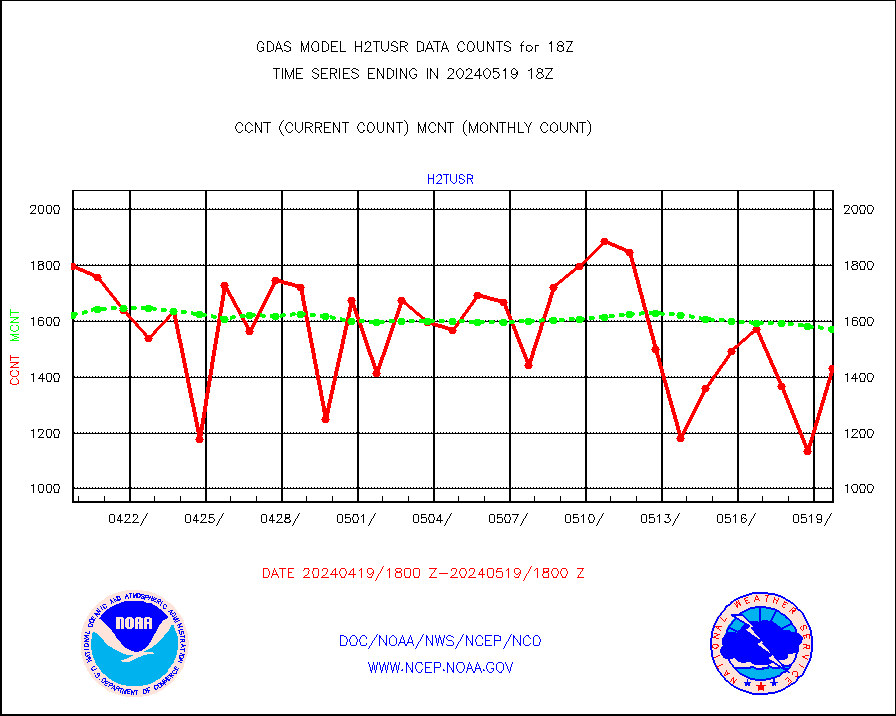
NOAA 15-19 & METOP 1-2 HIRS-3/4 pr btmps frm RARS |
0 |
160920 |
0.0 % |
|||||||||||
| Shortage in Data Type of Opportunity - Monitor | ||||||||||||||
|---|---|---|---|---|---|---|---|---|---|---|---|---|---|---|
| Type | Description | Hourly Count | Monthly Average | Percent (%) of Monthly Mean | ||||||||||
P.M.(N18-19) AVHRR GAC NCEP-proc clr & sea btemps |
0 |
2942951 |
0.0 % |
|||||||||||
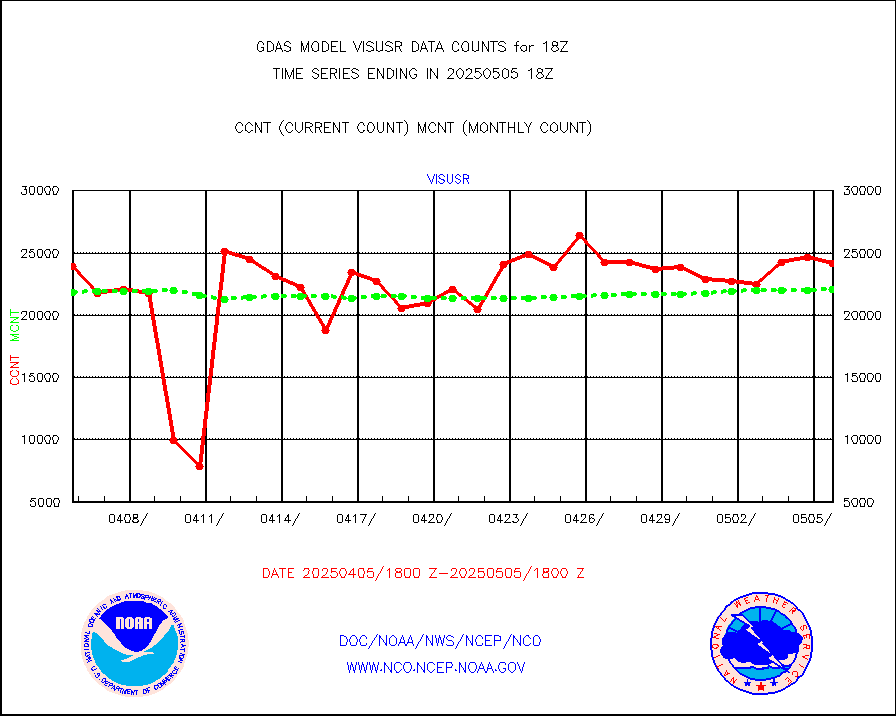
METOP 1-2 IASI 1C radiance data vbl chn from RARS |
0 |
27157 |
0.0 % |
|||||||||||
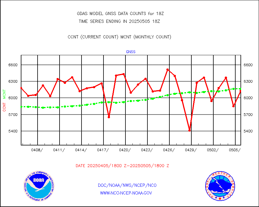
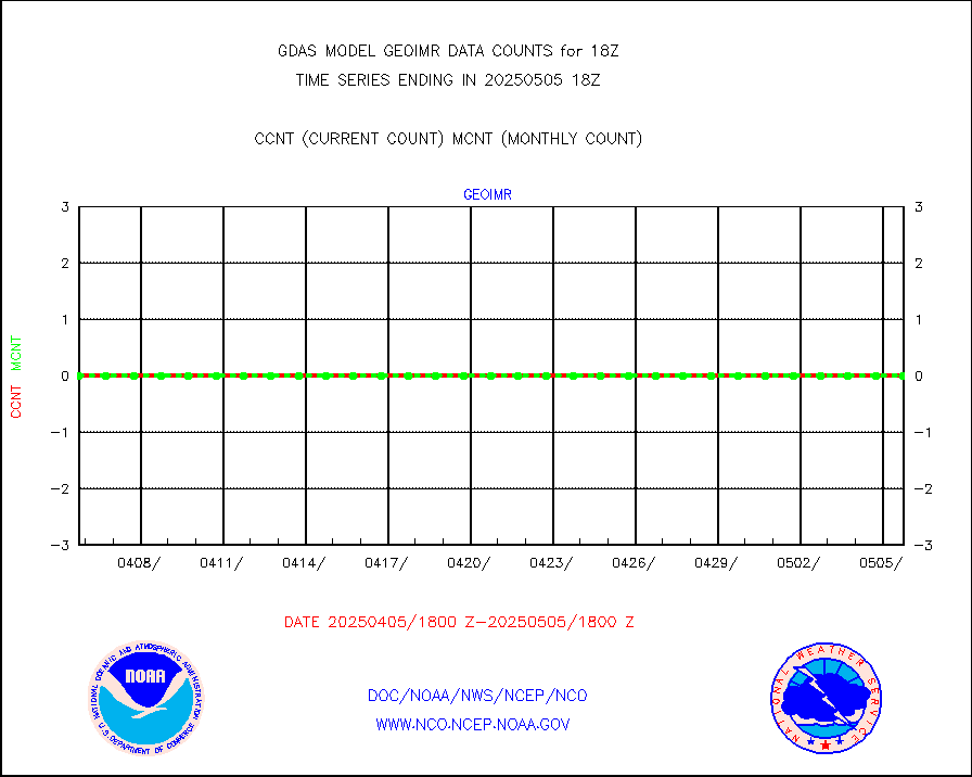
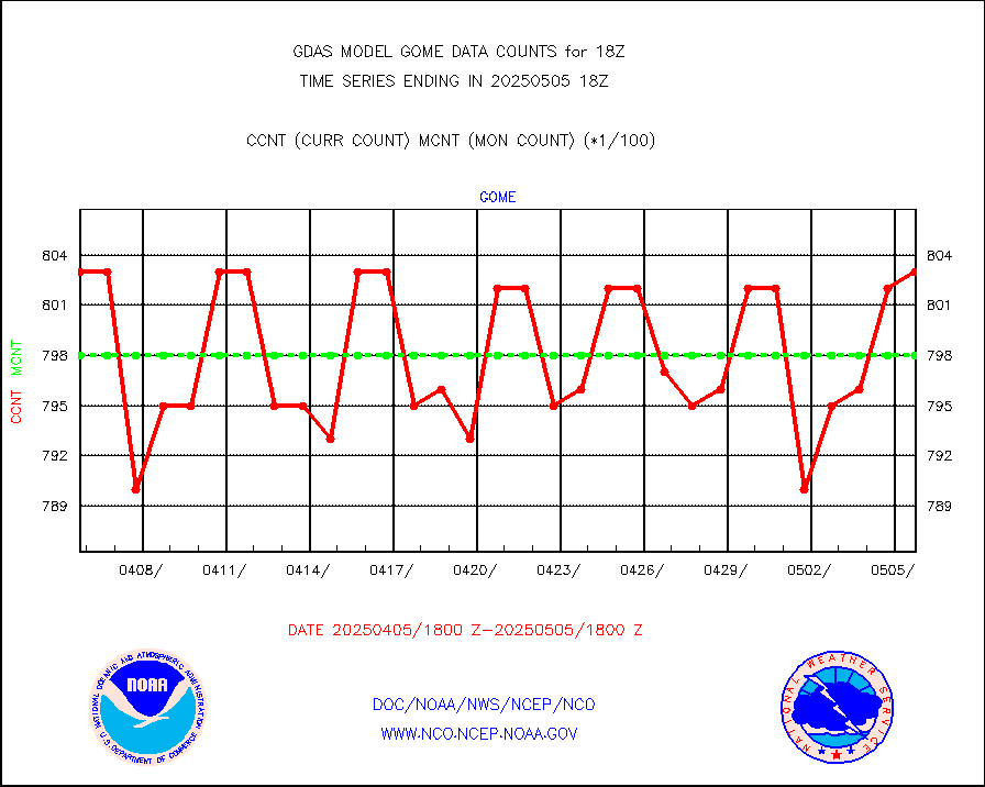
Grnd-based Gbl Navigation Sat System (GNSS) data |
1282 |
5435 |
23.6 % |
|||||||||||
DMSP SSM/IS 1C radiance data (Unified Pre-Proc.) |
411060 |
852182 |
48.2 % |
|||||||||||
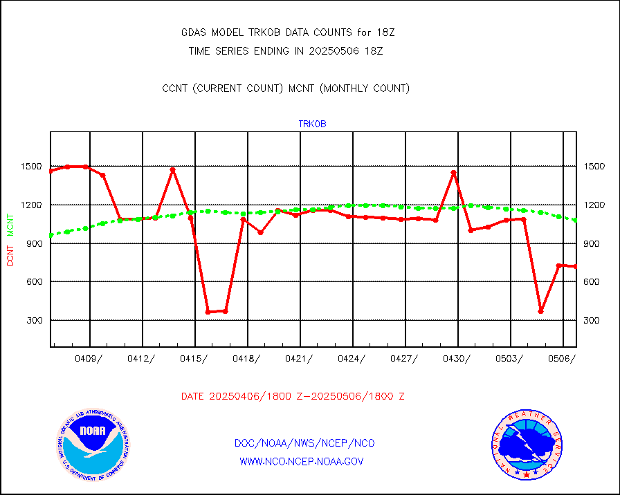
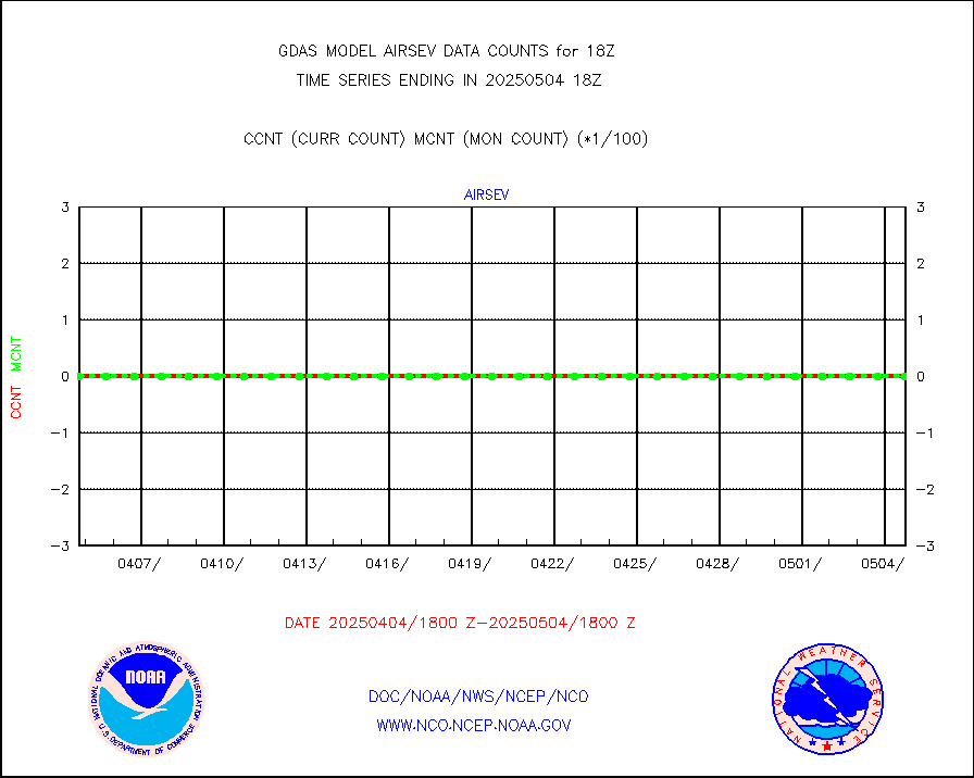
ThermoSalinoGraph (TSG) TRACKOB format) |
370 |
768 |
48.2 % |
|||||||||||
| Critical Data with Normal Counts | ||||||||||||||
|---|---|---|---|---|---|---|---|---|---|---|---|---|---|---|
| Type | Description | Hourly Count | Monthly Average | Percent (%) of Monthly Mean | ||||||||||
NOAA 15-19 & METOP 1-2 AMSU-A NCEP-proc. br.temps |
162043 |
248140 |
65.3 % |
|||||||||||
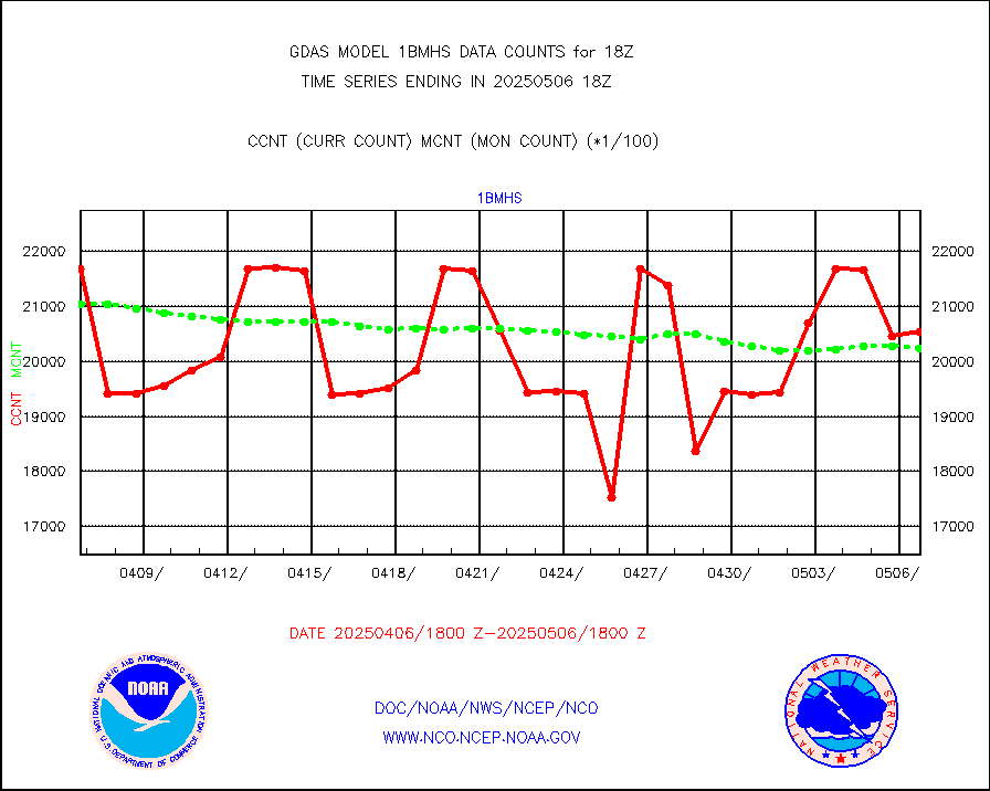
NOAA 18-19 & METOP 1-2 MHS NCEP-proces. br. temps |
1439660 |
1801230 |
79.9 % |
|||||||||||
MDCRS ACARS acft data from ARINC(dcded from BUFR) |
224648 |
210888 |
106.5 % |
|||||||||||
Himawari Clear Sky Radiance |
282006 |
288007 |
97.9 % |
|||||||||||
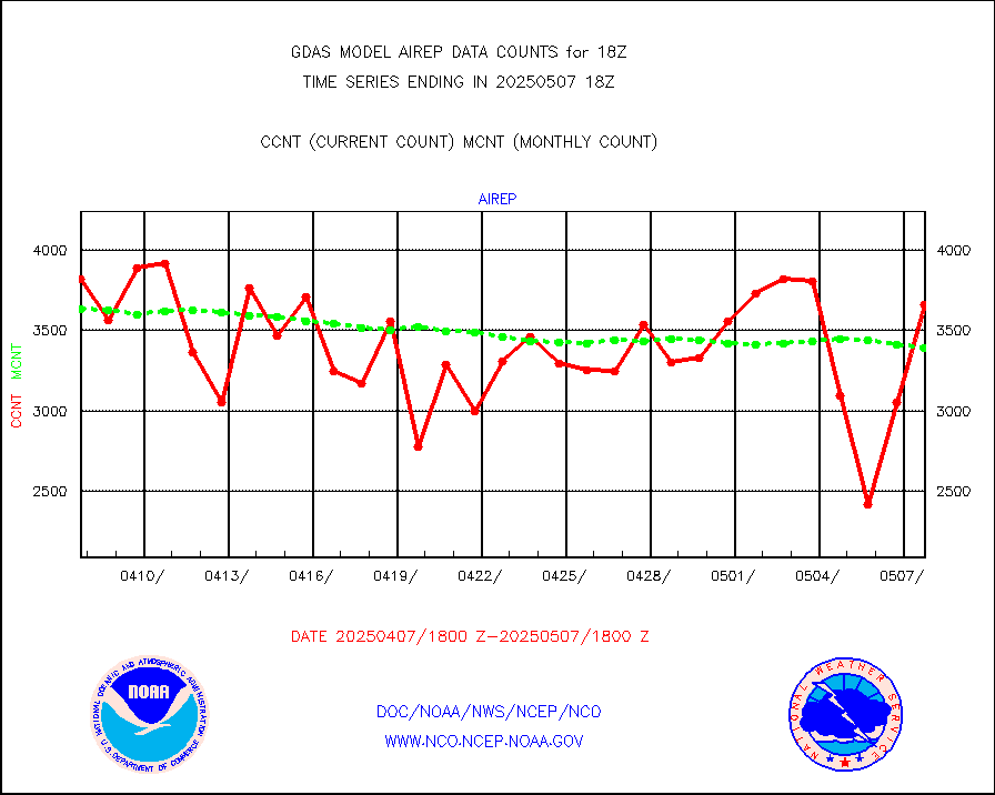
Manual AIREP aircraft data (dcded from AIREP fmt) |
4058 |
3649 |
111.2 % |
|||||||||||
AQUA AIRS/AMSU-A/HSB brightness temps- every FOV |
0 |
0 |
n/a |
|||||||||||
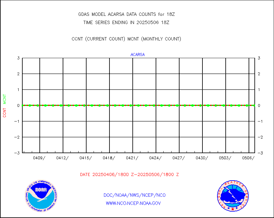
AMDAR aircraft data (decoded from AMDAR format) |
734 |
837 |
87.7 % |
|||||||||||
AMDAR aircraft data (decoded from BUFR) |
13281 |
13647 |
97.3 % |
|||||||||||
METOP 1-2 ASCAT products |
484512 |
484114 |
100.1 % |
|||||||||||
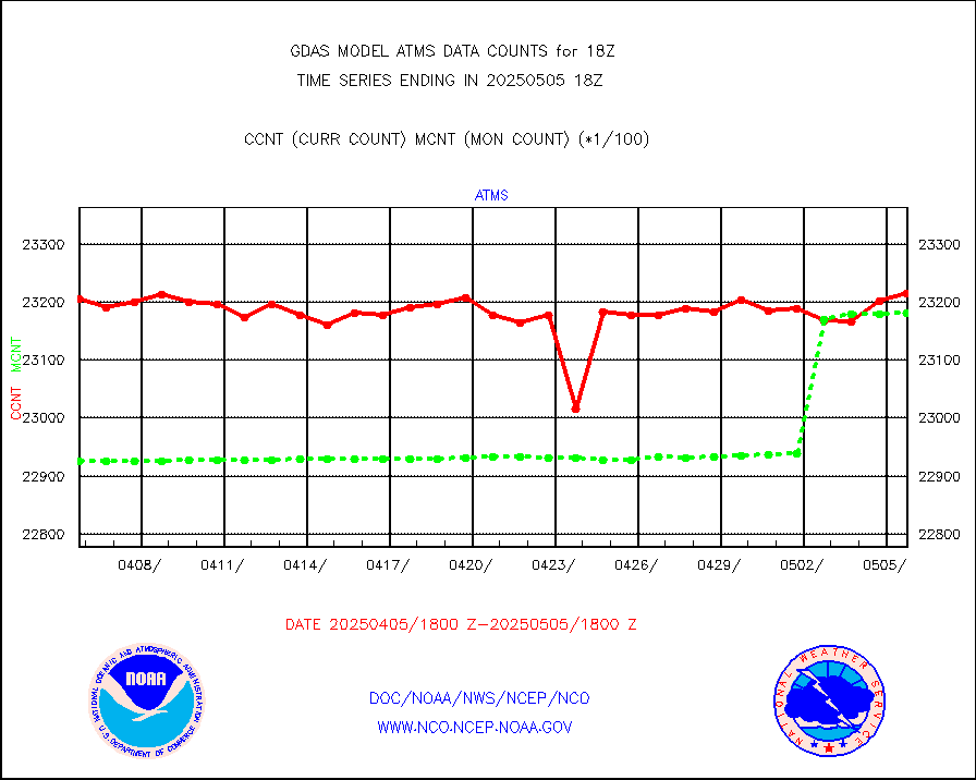
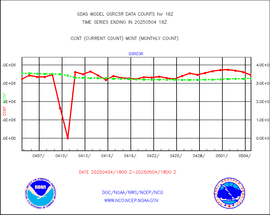
NPP/NOAA-20 ATMS brightness temperatures |
2317824 |
2287990 |
101.3 % |
|||||||||||
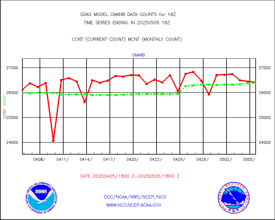
Surface Marine CMAN rpts decoded from BUFR format |
26872 |
26681 |
100.7 % |
|||||||||||
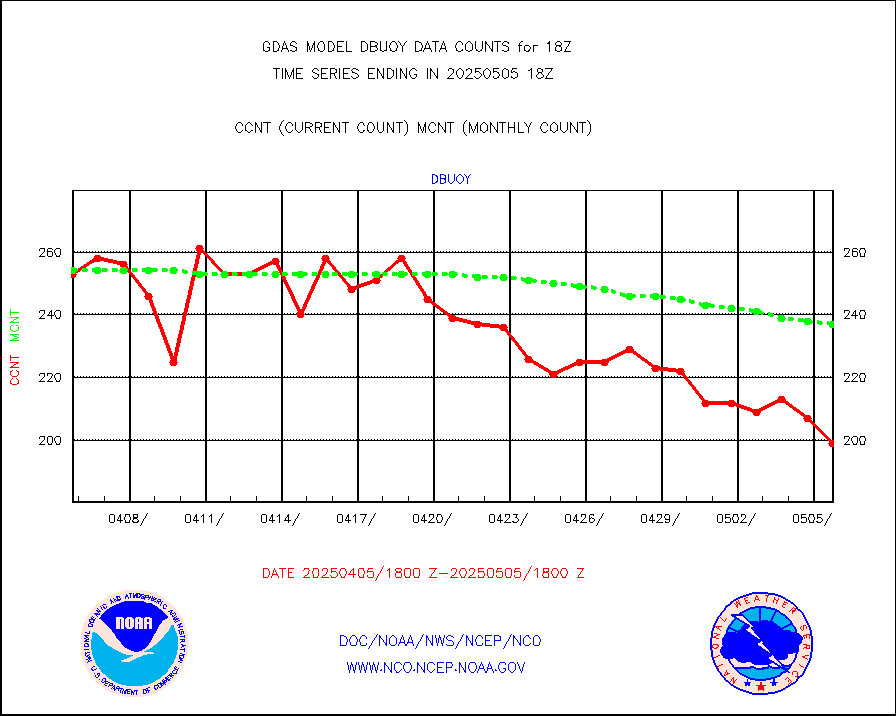
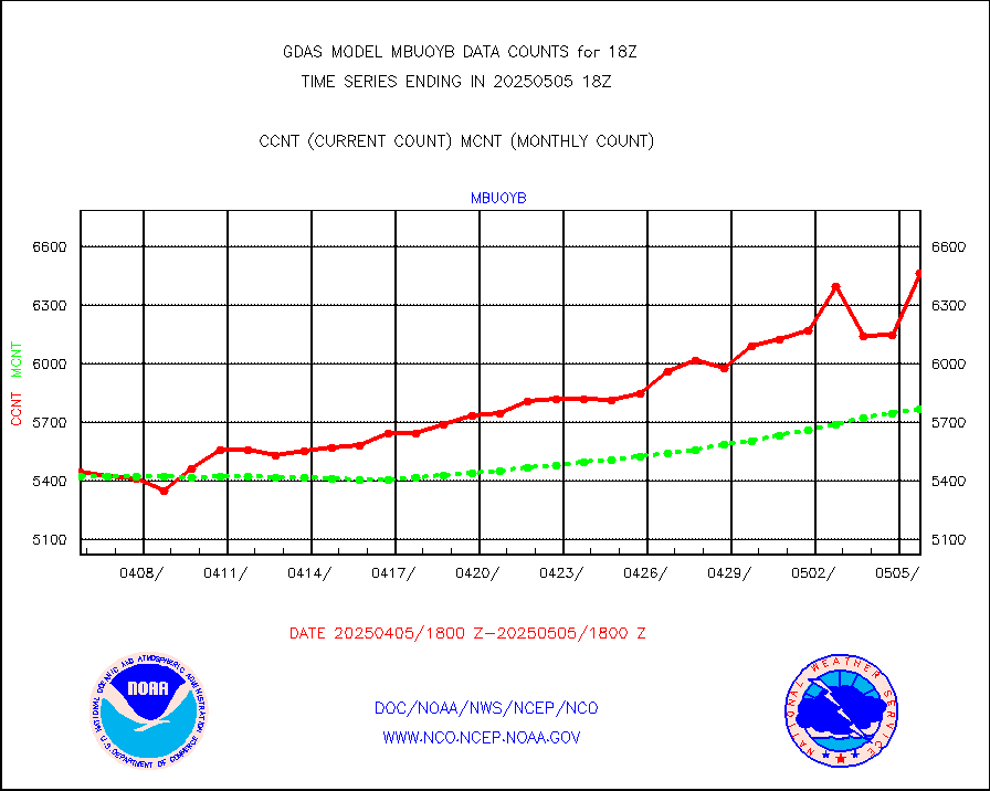
Buoys decoded from FM-18 fmt (moored or drifting) |
110 |
141 |
78.0 % |
|||||||||||
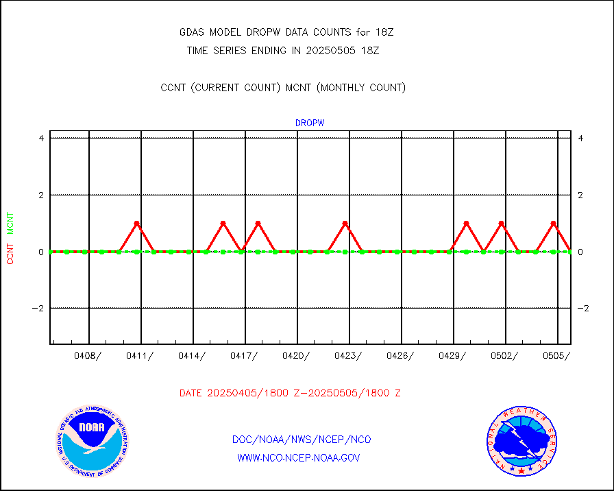
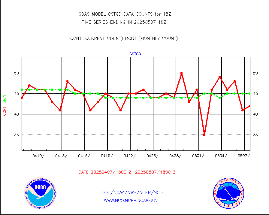
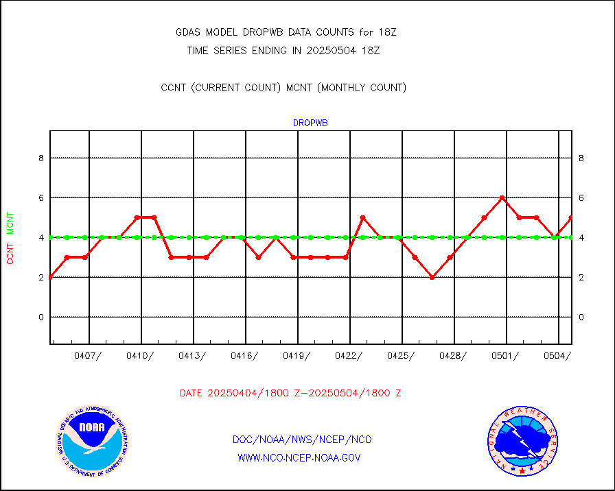
Dropwinsonde (from TEMP DROP) |
0 |
1 |
0.0 % |
|||||||||||
E-AMDAR (European AMDAR acft decoded from BUFR) |
21833 |
23661 |
92.3 % |
|||||||||||
NOAA 15-19 & METOP 1-2 AMSU-A proc btmps frm RARS |
70231 |
106070 |
66.2 % |
|||||||||||
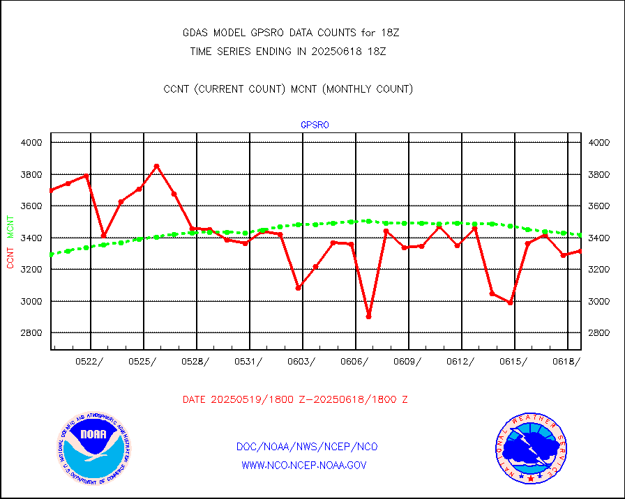
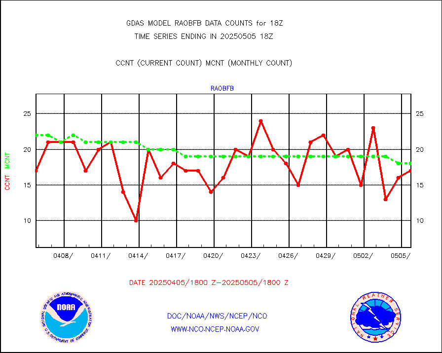
GPS radio occultation data |
3193 |
3270 |
97.6 % |
|||||||||||
GOES-16/17 All Sky Radiances (proc.) |
6488568 |
6468271 |
100.3 % |
|||||||||||
GOES-16/17 Clear Sky Radiances (proc.) |
3304173 |
3391137 |
97.4 % |
|||||||||||
MTSAT/JMA water vapor imager derived cloud motion |
59615 |
56510 |
105.5 % |
|||||||||||
MODIS (AQUA/TERRA) wvpr imager derived cld motion |
0 |
0 |
n/a |
|||||||||||
GOES-16&up/NESDIS wv imgr/cld-top derived cld mtn |
157359 |
161547 |
97.4 % |
|||||||||||
METEOSAT/EUMETSAT ir lg-wave drv cld motion NBseq |
129777 |
126023 |
103.0 % |
|||||||||||
MTSAT/JMA infrared long-wave derived cloud motion |
47830 |
45928 |
104.1 % |
|||||||||||
MODIS (AQUA/TERRA) ir l-wave derived cloud motion |
0 |
0 |
n/a |
|||||||||||
GOES-16&up/NESDIS ir long-wave derived cld motion |
521793 |
506205 |
103.1 % |
|||||||||||
Land-based CMAN stations decoded from CMAN format |
516 |
524 |
98.5 % |
|||||||||||
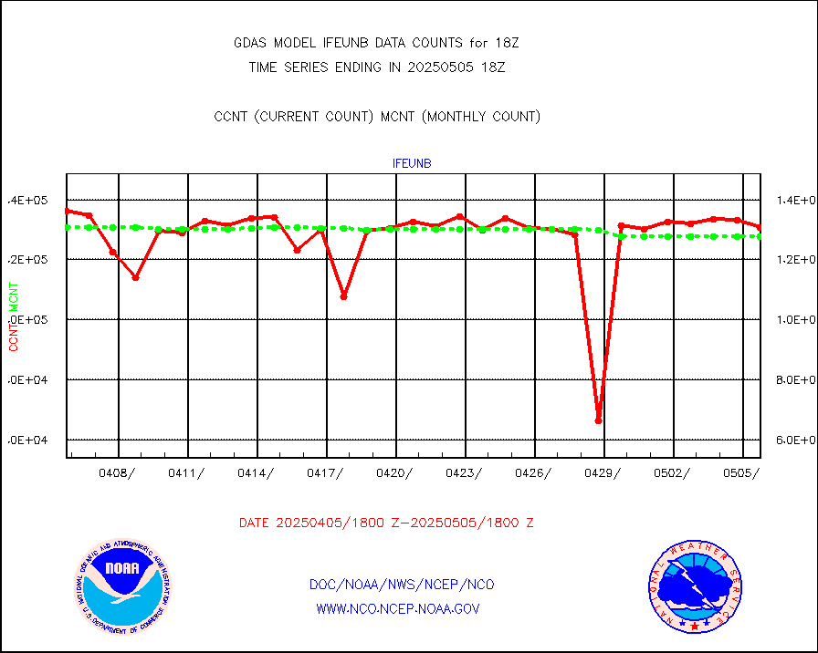
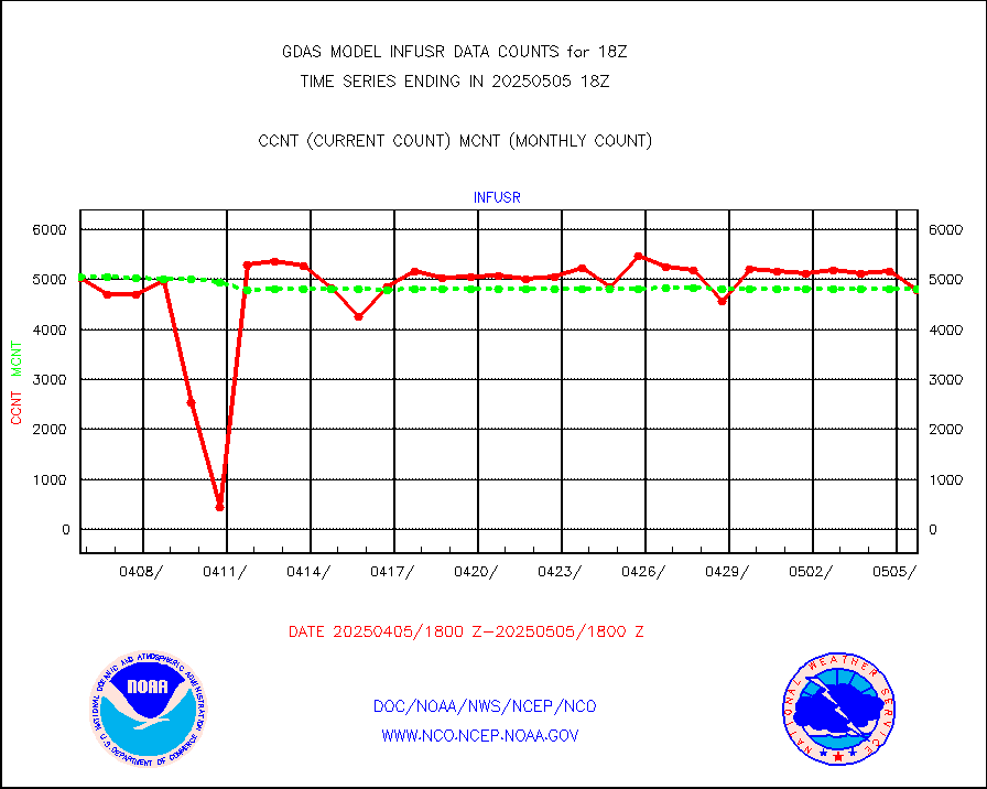
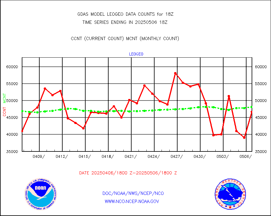
LEO-GEO satellite AMVs from UWisc. |
55106 |
56450 |
97.6 % |
|||||||||||
Buoys decoded from FM-13 format (moored) |
813 |
789 |
103.0 % |
|||||||||||
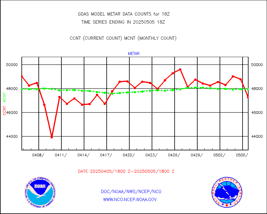
Aviation - METAR |
48370 |
47895 |
101.0 % |
|||||||||||
METOP 1-2 IASI 1C radiance data (varbl. channels) |
648000 |
642043 |
100.9 % |
|||||||||||
NEXRAD Vel Azm Dsp(VAD) winds via radar coded msg |
0 |
0 |
n/a |
|||||||||||
Aura Ozone Monitoring Instrument (OMI) data |
0 |
0 |
n/a |
|||||||||||
NOAA 16-19 Solar Backscatter UV-2 rad frm V8 BUFR |
0 |
0 |
n/a |
|||||||||||
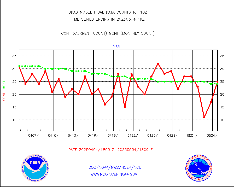
PIBAL (from PILOT, PILOT SHIP, PILOT MOBIL) |
25 |
20 |
125.0 % |
|||||||||||
Profilr winds from PIBAL (PILOT,PILOT SHIP/MOBIL) |
1 |
1 |
100.0 % |
|||||||||||
Rawinsonde - fixed land (from TEMP or PILOT) |
43 |
37 |
116.2 % |
|||||||||||
Rawinsonde - mobile land (from TEMP/PILOT MOBIL) |
0 |
0 |
n/a |
|||||||||||
Rawinsonde - ship (from TEMP SHIP, PILOT SHIP) |
1 |
1 |
100.0 % |
|||||||||||
Flight level reconnaissance aircraft data |
1 |
1 |
100.0 % |
|||||||||||
Ship - manual and automatic, restricted |
239 |
223 |
107.2 % |
|||||||||||
Ship - manual and automatic, restricted (BUFR) |
1067 |
1037 |
102.9 % |
|||||||||||
Ship - manual and automatic, unrestricted |
718 |
744 |
96.5 % |
|||||||||||
Ship - manual and automatic, unrestricted (BUFR) |
6200 |
6221 |
99.7 % |
|||||||||||
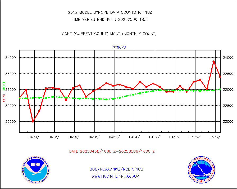
Synoptic - fixed manual & auto (decoded fr BUFR) |
39680 |
41388 |
95.9 % |
|||||||||||
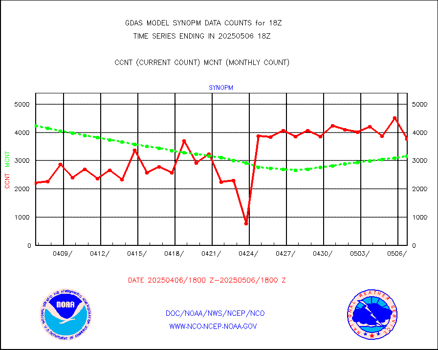
Synoptic - mobile manual and automatic |
4745 |
4158 |
114.1 % |
|||||||||||
Synoptic - restricted (WMO Res 40) manual & auto. |
3 |
5 |
60.0 % |
|||||||||||
Synoptic - restricted (WMO Res 40)(decoded BUFR) |
2301 |
2367 |
97.2 % |
|||||||||||
Synoptic - mobile manual & auto (decoded fr BUFR) |
253 |
288 |
87.8 % |
|||||||||||
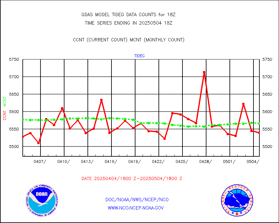
Tide gauge reports decoded from CREX format |
5594 |
5597 |
99.9 % |
|||||||||||
MTSAT/JMA visible derived cloud motion |
4132 |
3903 |
105.9 % |
|||||||||||
METEOSAT/EUMETSAT visible drv cld motion NBseq |
115687 |
101745 |
113.7 % |
|||||||||||
| Data Types of Opportunity with Normal Counts | ||||||||||||||
|---|---|---|---|---|---|---|---|---|---|---|---|---|---|---|
| Type | Description | Hourly Count | Monthly Average | Percent (%) of Monthly Mean | ||||||||||
GOES-16&up/NESDIS ir short-wv derived cld motion |
46619 |
37410 |
124.6 % |
|||||||||||
MDCRS ACARS acft data (ARINC via AFWA)(AIREP fmt) |
0 |
0 |
n/a |
|||||||||||
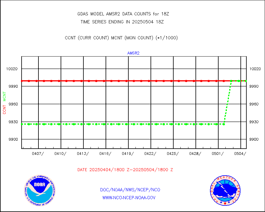
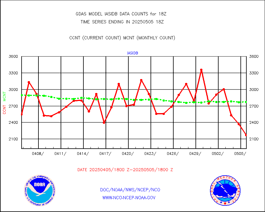
GCOM-W AMSR2 1B brightness temperatures |
9999999 |
9999999 |
100.0 % |
|||||||||||
NPP/NOAA-20 ATMS bright. temps-direct b-cast SSEC |
961163 |
863611 |
111.3 % |
|||||||||||
POES/NESDIS - processed ATOVS soundings/radiances |
0 |
0 |
n/a |
|||||||||||
A.M.(N17,M2,M3) AVHRR GAC NCEP-proc clr&sea btmps |
7099381 |
7407240 |
95.8 % |
|||||||||||
eXpendable BathyThermograph, mooring (BATHY fmt) |
0 |
1 |
0.0 % |
|||||||||||
Canadian AMDAR aircraft data (decoded from BUFR) |
0 |
0 |
n/a |
|||||||||||
NPP/NOAA-20 CrIS full spctrl radn (431 ch subset) |
1458000 |
1437343 |
101.4 % |
|||||||||||
NPP/NOAA-20 CrIS full spctrl radn dir brdcst SSEC |
440376 |
411697 |
107.0 % |
|||||||||||
Coast Guard |
43 |
45 |
95.6 % |
|||||||||||
Drifting buoys (decoded from BUFR) |
9103 |
9144 |
99.6 % |
|||||||||||
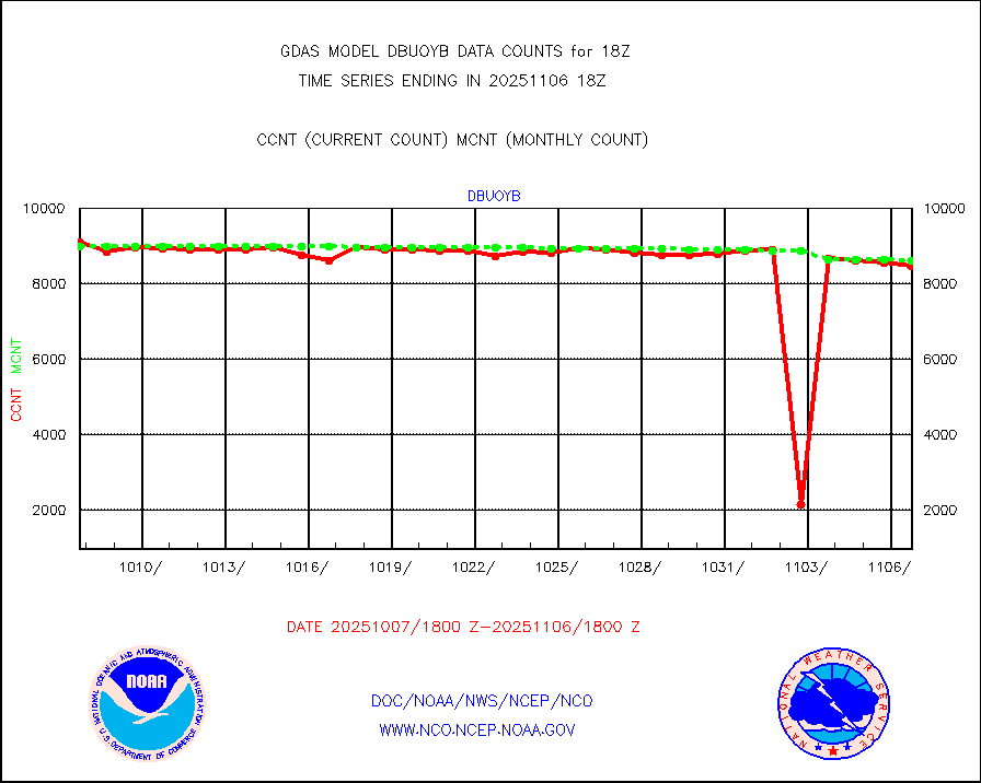
Dropwinsonde (decoded from BUFR) |
4 |
5 |
80.0 % |
|||||||||||
NPP Adv. Tech. MW Sndr (ATMS) br. temps from RARS |
195840 |
286668 |
68.3 % |
|||||||||||
NOAA 18-19 & METOP 1-2 MHS proc. btemps from RARS |
737243 |
1046705 |
70.4 % |
|||||||||||
GOES/NESDIS (11x17 f-o-v) imager clear radiances |
0 |
0 |
n/a |
|||||||||||
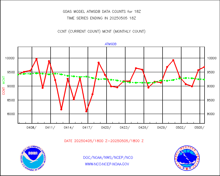
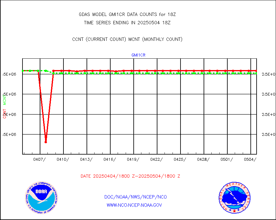
GPM GMI Level 1C-R brightness temperatures |
2541500 |
2541706 |
100.0 % |
|||||||||||
METOP 1-2 Global Ozone Monitoring Exp.-2 (GOME-2) |
79506 |
79820 |
99.6 % |
|||||||||||
INSAT/KALPANA India wvpr derived cloud motion |
0 |
0 |
n/a |
|||||||||||
INDIA SATWIND, INSAT WV channel |
20037 |
32920 |
60.9 % |
|||||||||||
GOES-16&up/NESDIS wv imgr/deep-lyr derivd cld mtn |
119748 |
103912 |
115.2 % |
|||||||||||
METEOSAT/EUMETSAT wvpr imgr drv cld motion NBseq |
222018 |
225881 |
98.3 % |
|||||||||||
High Density OBs from reconnaissance acft data |
220 |
181 |
121.5 % |
|||||||||||
METOP 1-2 IASI 1C radiances-direct broadcast SSEC |
300977 |
289729 |
103.9 % |
|||||||||||
VIIRS (NPP/NOAA-20) ir lg-wv drv cloud motion(NB) |
90426 |
99684 |
90.7 % |
|||||||||||
AVHRR (NOAA/METOP) ir lg-wave derived cld motion |
0 |
0 |
n/a |
|||||||||||
AVHRR (METOP) ir lg-wave derived cld motion |
61084 |
65391 |
93.4 % |
|||||||||||
INSAT/KALPANA India ir lg-wave derived cld motion |
0 |
0 |
n/a |
|||||||||||
INDIA SATWIND, INSAT IR channel |
29171 |
46969 |
62.1 % |
|||||||||||
Korean AMDAR aircraft data (decoded from BUFR) |
0 |
0 |
n/a |
|||||||||||
Moored buoys (decoded from BUFR) |
8165 |
7931 |
103.0 % |
|||||||||||
NEXRAD Vel Azm Dsp(VAD) winds via Level 2 decoder |
3739 |
3679 |
101.6 % |
|||||||||||
OMPS Limb Profiler ozone data (NPP) |
1617 |
1607 |
100.6 % |
|||||||||||
OMPS nadir profile ozone (Version 8 BUFR) |
3370 |
3360 |
100.3 % |
|||||||||||
OMPS total column ozone (Version 8 BUFR) |
1920049 |
2025358 |
94.8 % |
|||||||||||
PIBAL (decoded from BUFR) |
9 |
7 |
128.6 % |
|||||||||||
Manual PIREP aircraft data (dcded from AIREP fmt) |
1050 |
999 |
105.1 % |
|||||||||||
Multi-Agency Profiler (MAP) and SODAR winds |
472 |
433 |
109.0 % |
|||||||||||
Rawinsonde - fixed land (decoded from BUFR) |
29 |
28 |
103.6 % |
|||||||||||
Rawinsonde - mobile land (decoded from BUFR) |
0 |
0 |
n/a |
|||||||||||
Rawinsonde - ship (decoded from BUFR) |
2 |
2 |
100.0 % |
|||||||||||
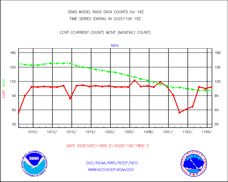
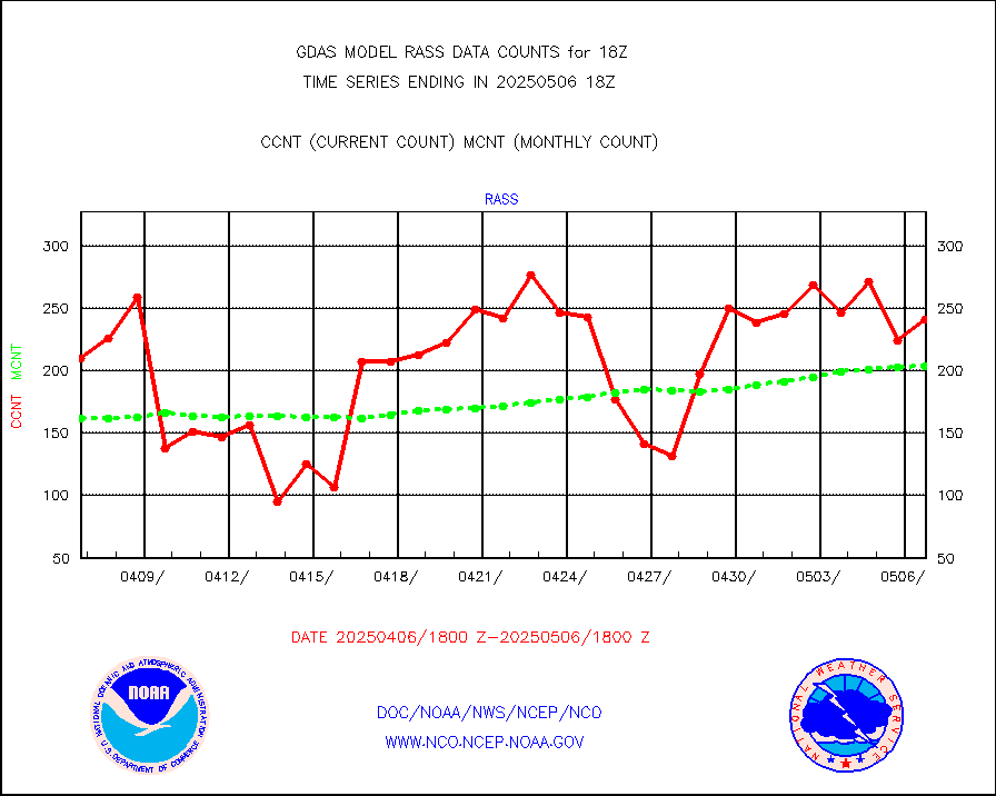
RASS temperatures (NOAA and Multi-Agency) |
213 |
194 |
109.8 % |
|||||||||||
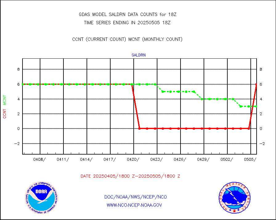
Surface Marine Saildrone (decoded from BUFR) |
6 |
6 |
100.0 % |
|||||||||||
METEOSAT-10 2nd Gen SEVIRI All Sky Radiance(proc) |
452614 |
452772 |
100.0 % |
|||||||||||
NOW COVER, DEPTH/DENSITY AND WATER EQUIVALENT |
18136 |
18183 |
99.7 % |
|||||||||||
NPP/NOAA-20 VIIRS SST - CLEAR & OVER WATER |
31 |
31 |
100.0 % |
|||||||||||
NPP/NOAA-20 VIIRS SST - PROBABLY CLR & OVER WATER |
9999999 |
9999999 |
100.0 % |
|||||||||||
Synoptic - fixed manual and automatic |
7167 |
6966 |
102.9 % |
|||||||||||
CTD probe, Argo prflng float, mooring (TESAC fmt) |
3046 |
2942 |
103.5 % |
|||||||||||
TAMDAR aircft data-all types(from Panasonic,BUFR) |
276 |
354 |
78.0 % |
|||||||||||
INSAT/KALPANA India visible derived cloud motion |
0 |
0 |
n/a |
|||||||||||
INDIA SATWIND, INSAT VIS channel |
0 |
0 |
n/a |
|||||||||||
GOES-16&up/NESDIS visible derived cloud motion |
2996549 |
2766699 |
108.3 % |
|||||||||||


