| Suspect Data Shortages in Critical Types - Monitor | ||||||||||||||
|---|---|---|---|---|---|---|---|---|---|---|---|---|---|---|
| Type | Description | Hourly Count | Monthly Average | Percent (%) of Monthly Mean | UTC Time Window | |||||||||
NOAA 18-19 & METOP 1-2 HIRS-4 NCEP-proc. br.temps |
0 |
5227 |
0.0 % |
0314.00-0319.99 |
||||||||||
| Shortage in Data Type of Opportunity - Monitor | ||||||||||||||
|---|---|---|---|---|---|---|---|---|---|---|---|---|---|---|
| Type | Description | Hourly Count | Monthly Average | Percent (%) of Monthly Mean | UTC Time Window | |||||||||
NOAA 15-19 & METOP 1-2 HIRS-3/4 pr btmps frm RARS |
0 |
4960 |
0.0 % |
0316.00-0318.00 |
||||||||||
| Critical Data with Normal Counts | ||||||||||||||
|---|---|---|---|---|---|---|---|---|---|---|---|---|---|---|
| Type | Description | Hourly Count | Monthly Average | Percent (%) of Monthly Mean | UTC Time Window | |||||||||
NOAA 15-19 & METOP 1-2 AMSU-A NCEP-proc. br.temps |
13158 |
18041 |
72.9 % |
0314.00-0319.99 |
||||||||||
NOAA 18-19 & METOP 1-2 MHS NCEP-proces. br. temps |
116950 |
144031 |
81.2 % |
0314.00-0319.99 |
||||||||||
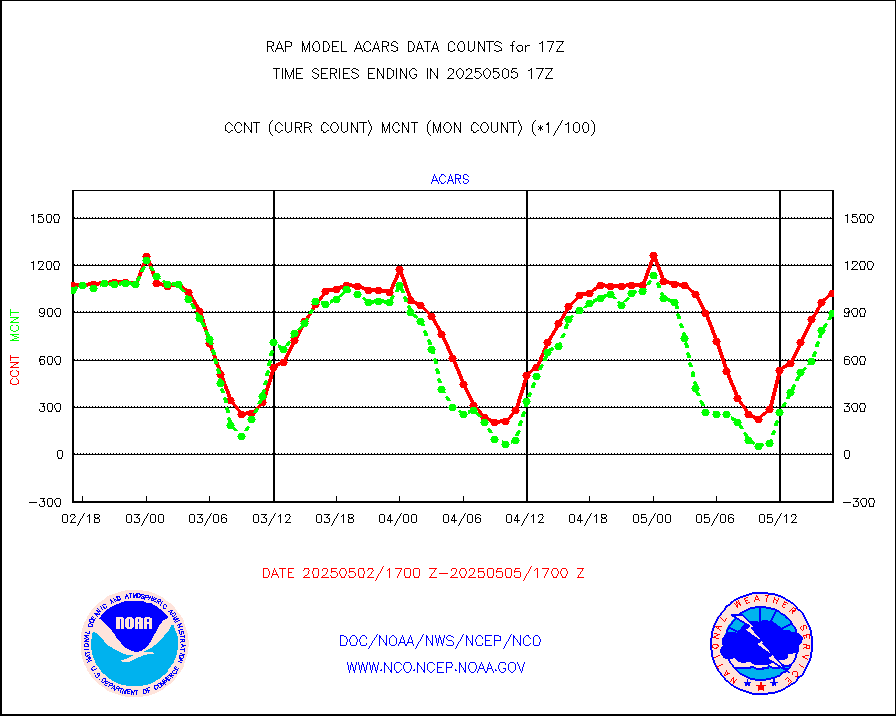
MDCRS ACARS acft data from ARINC(dcded from BUFR) |
117719 |
123494 |
95.3 % |
0313.75-0320.25 |
||||||||||
Canadian AMDAR aircraft data (decoded from BUFR) |
0 |
0 |
n/a |
0313.75-0320.25 |
||||||||||
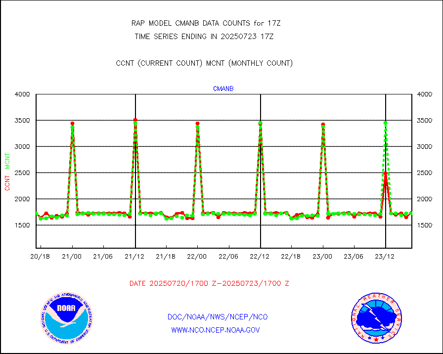
Surface Marine CMAN rpts decoded from BUFR format |
1735 |
1724 |
100.6 % |
0316.50-0317.50 |
||||||||||
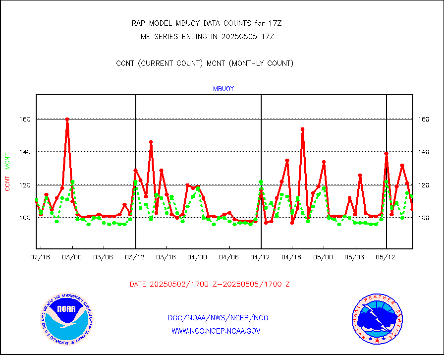
Buoys decoded from FM-18 fmt (moored or drifting) |
0 |
0 |
n/a |
0316.50-0317.50 |
||||||||||
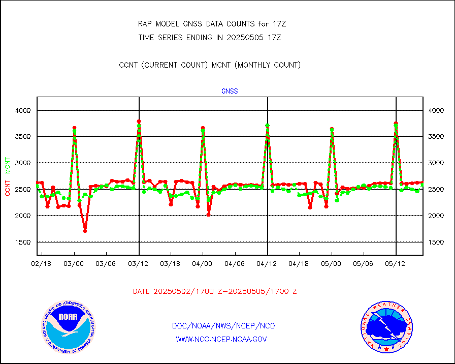
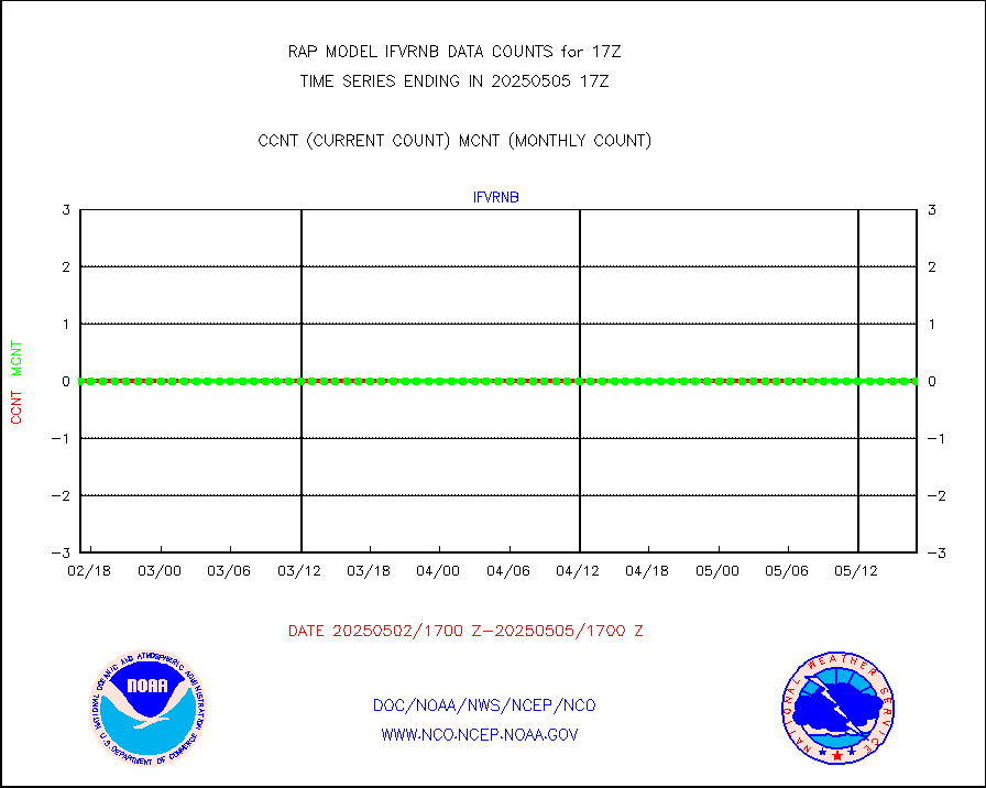
Grnd-based Gbl Navigation Sat System (GNSS) data |
2244 |
2092 |
107.3 % |
0315.95-0316.05 |
||||||||||
MODIS (AQUA/TERRA) wvpr imager derived cld motion |
0 |
0 |
n/a |
0314.50-0319.50 |
||||||||||
MODIS (AQUA/TERRA) ir l-wave derived cloud motion |
0 |
0 |
n/a |
0314.50-0319.50 |
||||||||||
GOES/NASA(Langley) hi-res. (1x1 f-o-v) cloud data |
3900658 |
3789105 |
102.9 % |
0316.50-0317.50 |
||||||||||
Buoys decoded from FM-13 format (moored) |
160 |
132 |
121.2 % |
0316.50-0317.50 |
||||||||||
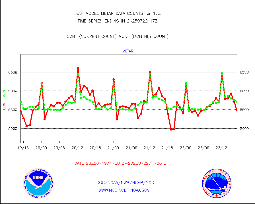
Aviation - METAR |
5901 |
5804 |
101.7 % |
0316.50-0317.50 |
||||||||||
NEXRAD Vel Azm Dsp(VAD) winds via radar coded msg |
0 |
0 |
n/a |
0316.00-0318.00 |
||||||||||
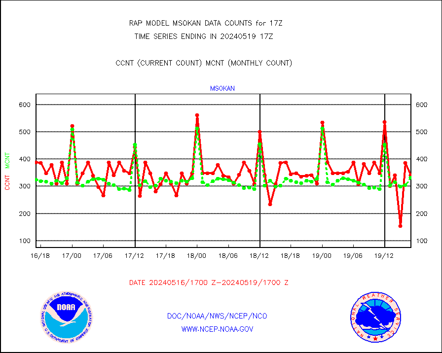
Multi-Agency Profiler (MAP) and SODAR winds |
81 |
98 |
82.7 % |
0315.50-0318.50 |
||||||||||
Rawinsonde - fixed land (from TEMP or PILOT) |
1 |
1 |
100.0 % |
0316.00-0318.00 |
||||||||||
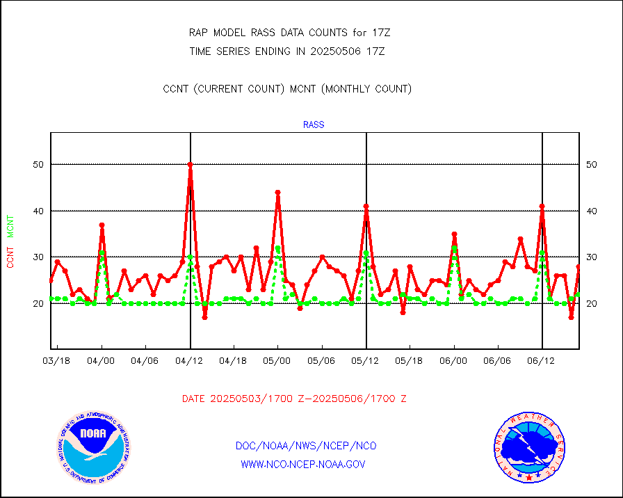
RASS temperatures (NOAA and Multi-Agency) |
17 |
22 |
77.3 % |
0316.50-0317.50 |
||||||||||
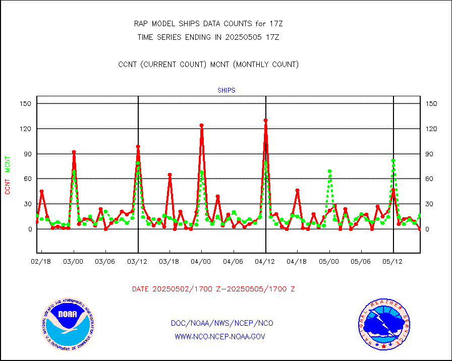
Ship - manual and automatic, restricted (BUFR) |
6 |
9 |
66.7 % |
0316.50-0317.50 |
||||||||||
Ship - manual and automatic, unrestricted |
80 |
80 |
100.0 % |
0316.50-0317.50 |
||||||||||
Ship - manual and automatic, unrestricted (BUFR) |
820 |
754 |
108.8 % |
0316.50-0317.50 |
||||||||||
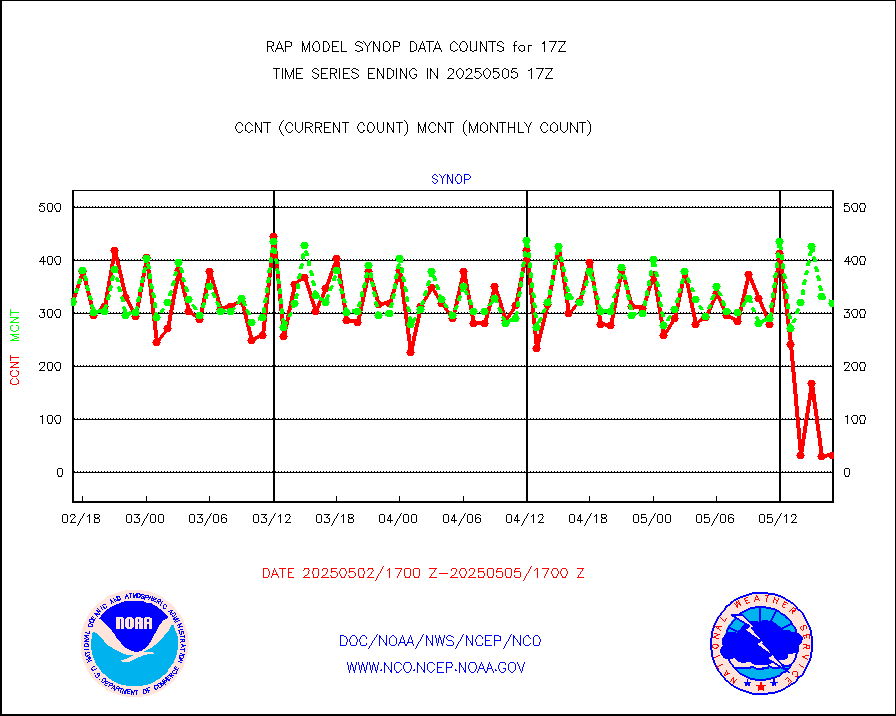
Synoptic - fixed manual and automatic |
240 |
341 |
70.4 % |
0316.50-0317.50 |
||||||||||
Synoptic - fixed manual & auto (decoded fr BUFR) |
2128 |
1983 |
107.3 % |
0316.50-0317.50 |
||||||||||
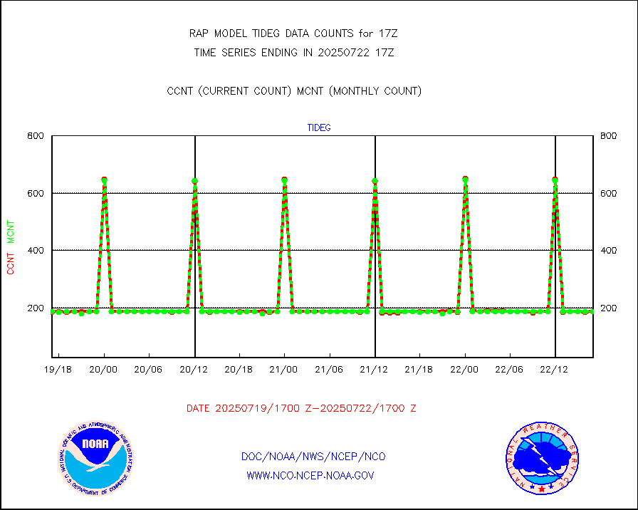
Tide gauge reports decoded from CREX format |
188 |
185 |
101.6 % |
0316.50-0317.50 |
||||||||||
| Data Types of Opportunity with Normal Counts | ||||||||||||||
|---|---|---|---|---|---|---|---|---|---|---|---|---|---|---|
| Type | Description | Hourly Count | Monthly Average | Percent (%) of Monthly Mean | UTC Time Window | |||||||||
GOES-16&up/NESDIS ir short-wv derived cld motion |
1641 |
1611 |
101.9 % |
0316.00-0316.99 |
||||||||||
MDCRS ACARS acft data (ARINC via AFWA)(AIREP fmt) |
0 |
0 |
n/a |
0313.75-0320.25 |
||||||||||
Manual AIREP aircraft data (dcded from AIREP fmt) |
2836 |
3090 |
91.8 % |
0313.75-0320.25 |
||||||||||
AQUA AIRS/AMSU-A/HSB brightness temps- every FOV |
0 |
0 |
n/a |
0314.00-0319.99 |
||||||||||
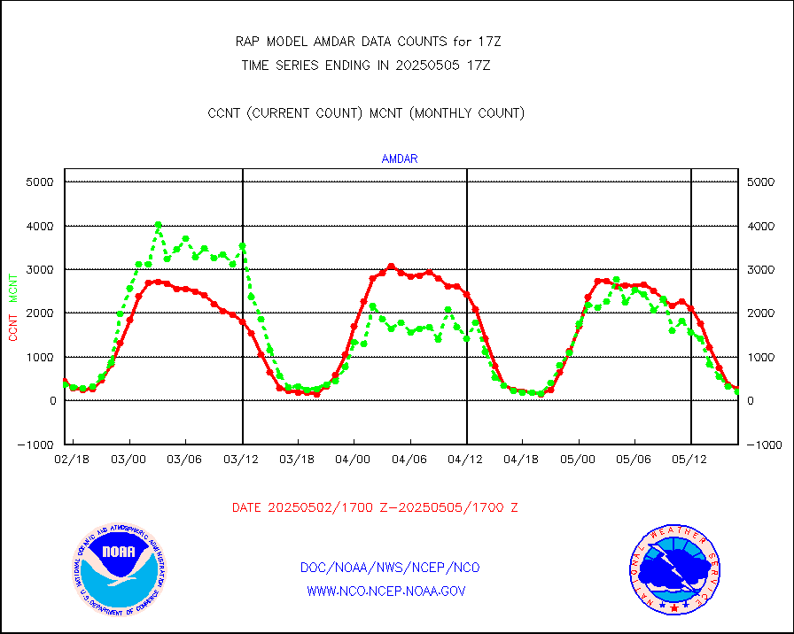
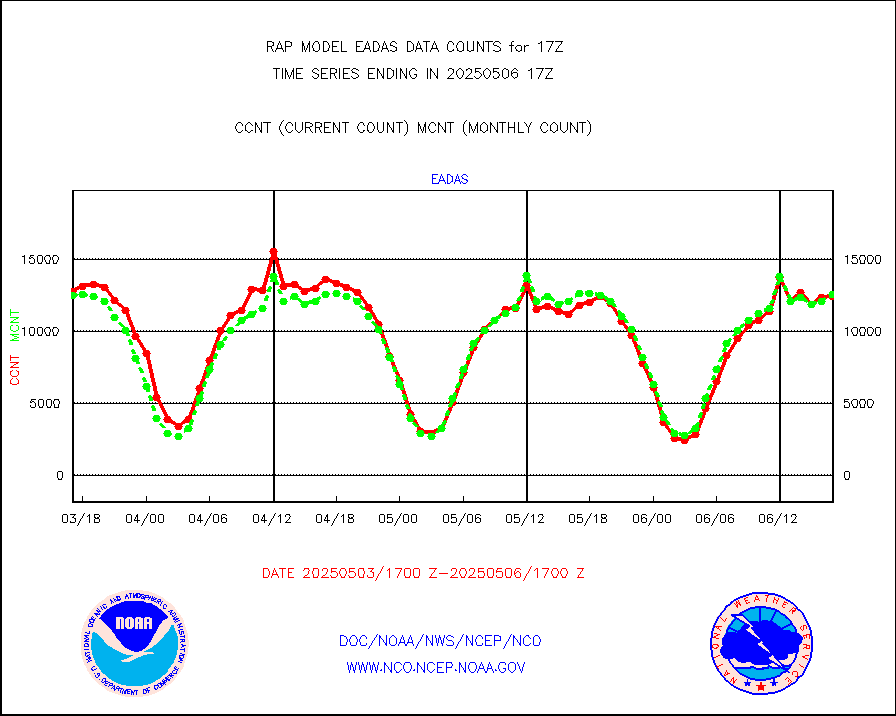
AMDAR aircraft data (decoded from AMDAR format) |
314 |
409 |
76.8 % |
0313.75-0320.25 |
||||||||||
AMDAR aircraft data (decoded from BUFR) |
8506 |
8812 |
96.5 % |
0313.75-0320.25 |
||||||||||
GCOM-W AMSR2 1B brightness temperatures |
1194722 |
748812 |
159.5 % |
0314.00-0314.99 |
||||||||||
METOP 1-2 ASCAT products |
17285 |
20419 |
84.7 % |
0315.00-0319.00 |
||||||||||
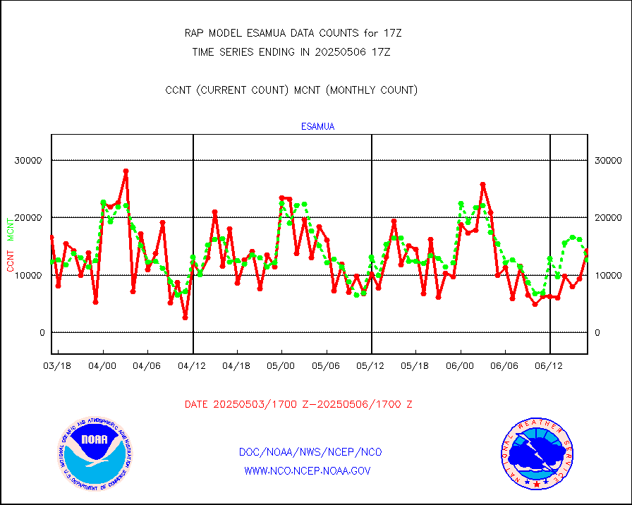
NPP/NOAA-20 ATMS brightness temperatures |
216843 |
207169 |
104.7 % |
0315.00-0318.99 |
||||||||||
NPP/NOAA-20 ATMS bright. temps-direct b-cast SSEC |
123714 |
138248 |
89.5 % |
0315.00-0318.99 |
||||||||||
Coop/MADIS NEPP & HCN-Modernization NOAA COOP Obs |
11 |
11 |
100.0 % |
0316.50-0317.50 |
||||||||||
NPP/NOAA-20 CrIS full spctrl radn (431 ch subset) |
107897 |
114160 |
94.5 % |
0315.00-0318.99 |
||||||||||
NPP/NOAA-20 CrIS full spctrl radn dir brdcst SSEC |
54612 |
52997 |
103.0 % |
0315.00-0318.99 |
||||||||||
Coast Guard |
5 |
6 |
83.3 % |
0316.50-0317.50 |
||||||||||
Drifting buoys (decoded from BUFR) |
543 |
532 |
102.1 % |
0316.50-0317.50 |
||||||||||
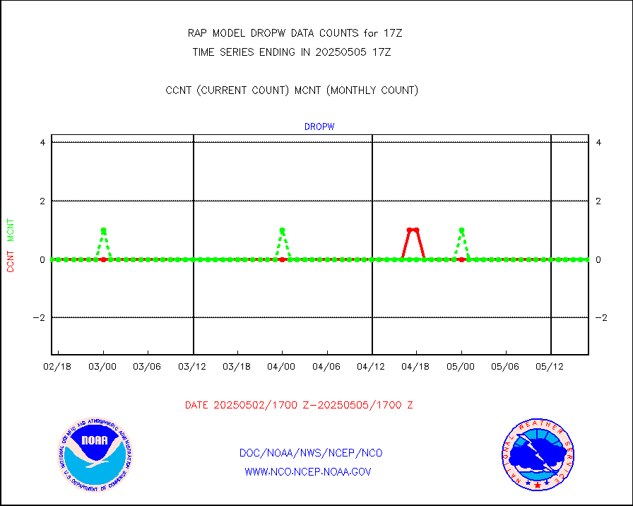
Dropwinsonde (from TEMP DROP) |
0 |
0 |
n/a |
0316.00-0318.00 |
||||||||||
Dropwinsonde (decoded from BUFR) |
0 |
0 |
n/a |
0316.00-0318.00 |
||||||||||
E-AMDAR (European AMDAR acft decoded from BUFR) |
11479 |
11990 |
95.7 % |
0313.75-0320.25 |
||||||||||
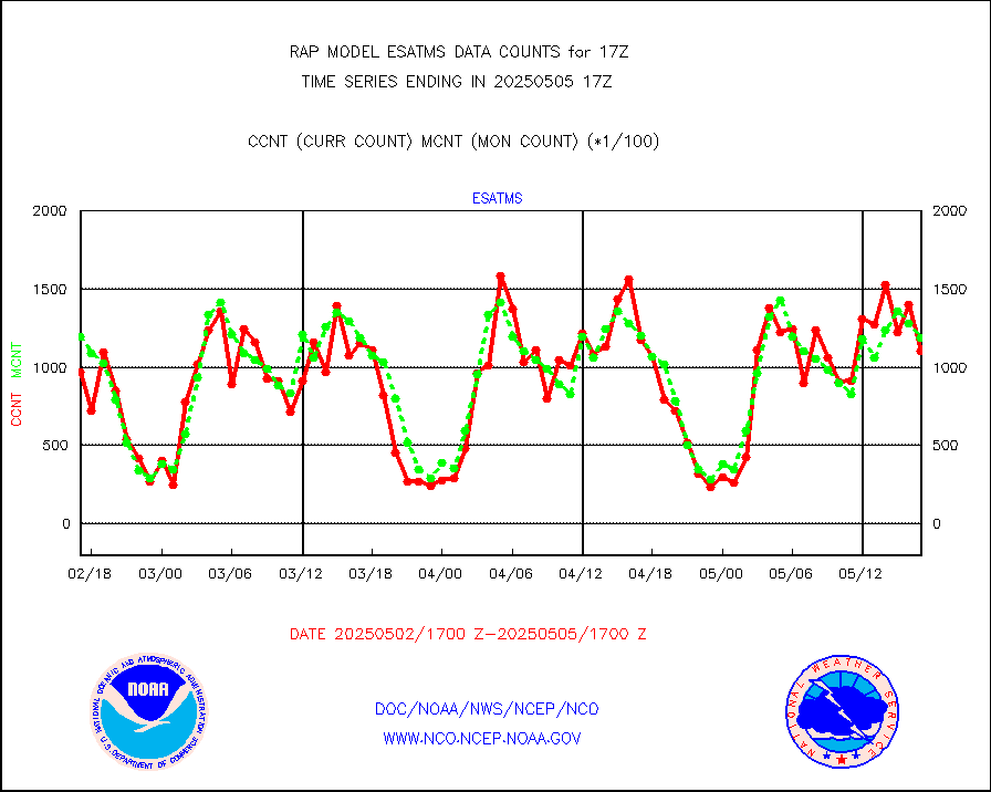
NOAA 15-19 & METOP 1-2 AMSU-A proc btmps frm RARS |
10200 |
7976 |
127.9 % |
0316.00-0318.00 |
||||||||||
NPP Adv. Tech. MW Sndr (ATMS) br. temps from RARS |
8550 |
5388 |
158.7 % |
0315.00-0318.99 |
||||||||||
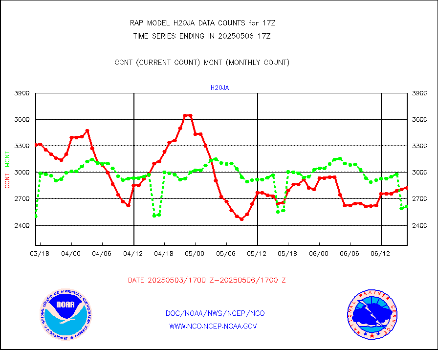
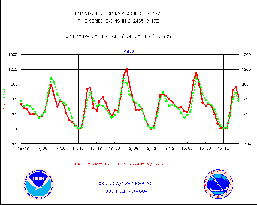
METOP 1-2 IASI 1C radiance data vbl chn from RARS |
56048 |
1733 |
n/a |
0315.00-0318.99 |
||||||||||
NOAA 18-19 & METOP 1-2 MHS proc. btemps from RARS |
93866 |
86542 |
108.5 % |
0316.00-0318.00 |
||||||||||
GPM GMI Level 1C-R brightness temperatures |
379021 |
227177 |
166.8 % |
0314.00-0319.99 |
||||||||||
GPS radio occultation data |
130 |
130 |
100.0 % |
0315.00-0318.99 |
||||||||||
GOES-16/17 All Sky Radiances (proc.) |
959751 |
953545 |
100.7 % |
0315.00-0318.99 |
||||||||||
GOES-16/17 Clear Sky Radiances (proc.) |
448195 |
451003 |
99.4 % |
0315.00-0318.99 |
||||||||||
MTSAT/JMA water vapor imager derived cloud motion |
3343 |
2743 |
121.9 % |
0314.50-0319.50 |
||||||||||
GOES-16&up/NESDIS wv imgr/deep-lyr derivd cld mtn |
8510 |
7749 |
109.8 % |
0316.00-0316.99 |
||||||||||
METEOSAT/EUMETSAT wvpr imgr drv cld motion NBseq |
5569 |
5451 |
102.2 % |
0315.50-0318.49 |
||||||||||
GOES-16&up/NESDIS wv imgr/cld-top derived cld mtn |
13874 |
13022 |
106.5 % |
0316.00-0316.99 |
||||||||||
METOP 1-2 IASI 1C radiances-direct broadcast SSEC |
83145 |
82570 |
100.7 % |
0315.00-0318.99 |
||||||||||
METEOSAT/EUMETSAT ir lg-wave drv cld motion NBseq |
3197 |
3086 |
103.6 % |
0315.50-0318.49 |
||||||||||
VIIRS (NPP/NOAA-20) ir lg-wv drv cloud motion(NB) |
0 |
0 |
n/a |
0314.50-0319.50 |
||||||||||
AVHRR (NOAA/METOP) ir lg-wave derived cld motion |
0 |
0 |
n/a |
0314.50-0319.50 |
||||||||||
AVHRR (METOP) ir lg-wave derived cld motion |
0 |
0 |
n/a |
0315.50-0318.49 |
||||||||||
MTSAT/JMA infrared long-wave derived cloud motion |
2735 |
2166 |
126.3 % |
0314.50-0319.50 |
||||||||||
GOES-16&up/NESDIS ir long-wave derived cld motion |
32720 |
30150 |
108.5 % |
0316.00-0316.99 |
||||||||||
Korean AMDAR aircraft data (decoded from BUFR) |
0 |
0 |
n/a |
0313.75-0320.25 |
||||||||||
Land-based CMAN stations decoded from CMAN format |
68 |
63 |
107.9 % |
0316.50-0317.50 |
||||||||||
LLDN Long-rng lightning from Vaisala via NOAAPORT |
81448 |
109290 |
74.5 % |
0316.00-0317.50 |
||||||||||
NLDN Shrt-rng lightning from Vaisala via NOAAPORT |
4120 |
5359 |
76.9 % |
0316.00-0317.50 |
||||||||||
Moored buoys (decoded from BUFR) |
711 |
659 |
107.9 % |
0316.50-0317.50 |
||||||||||
Mesonet/MADIS Colorado E-470 (Interstate 470) |
24 |
23 |
104.3 % |
0316.50-0317.50 |
||||||||||
Mesonet/MADIS Alaska Department of Transportation |
116 |
93 |
124.7 % |
0316.50-0317.50 |
||||||||||
Mesonet/MADIS U.S. Army Aberdeen Proving Grounds |
0 |
0 |
n/a |
0316.50-0317.50 |
||||||||||
Mesonet/MADIS Citizen Weather Observers Program |
56831 |
55713 |
102.0 % |
0316.50-0317.50 |
||||||||||
Mesonet/MADIS AWS Convergence Technologies, Inc. |
21507 |
19615 |
109.6 % |
0316.50-0317.50 |
||||||||||
Mesonet/MADIS "Anything Weather" |
0 |
0 |
n/a |
0316.50-0317.50 |
||||||||||
Mesonet/MADIS Colorado Dept. of Transportation |
0 |
0 |
n/a |
0316.50-0317.50 |
||||||||||
Mesonet/MADIS DC Net |
0 |
0 |
n/a |
0316.50-0317.50 |
||||||||||
Mesonet/MADIS Denver Urban Drainage & Flood Cntrl |
0 |
0 |
n/a |
0316.50-0317.50 |
||||||||||
Mesonet/MADIS Florida (FAWN & USF) |
2 |
3 |
66.7 % |
0316.50-0317.50 |
||||||||||
Mesonet/MADIS Florida Dept. of Transportation |
0 |
0 |
n/a |
0316.50-0317.50 |
||||||||||
Mesonet/MADIS Georgia Dept. of Transportation |
0 |
0 |
n/a |
0316.50-0317.50 |
||||||||||
Mesonet/MADIS NWS Hydromet Auto Data System(HADS) |
5376 |
4963 |
108.3 % |
0316.50-0317.50 |
||||||||||
Mesonet/MADIS Iowa Environmental |
178 |
159 |
111.9 % |
0316.50-0317.50 |
||||||||||
Mesonet/MADIS Indiana Dept. of Transportation |
0 |
0 |
n/a |
0316.50-0317.50 |
||||||||||
Mesonet/MADIS Iowa Department of Transportation |
0 |
0 |
n/a |
0316.50-0317.50 |
||||||||||
Mesonet/MADIS Kansas Department of Transportation |
340 |
329 |
103.3 % |
0316.50-0317.50 |
||||||||||
Mesonet/MADIS Oklahoma Mesonet |
630 |
550 |
114.5 % |
0316.50-0317.50 |
||||||||||
Mesonet/MADIS Louisiana State/Jackson State Univ. |
0 |
0 |
n/a |
0316.50-0317.50 |
||||||||||
Mesonet/MADIS Missouri Commercial Agricult Wx Net |
285 |
285 |
100.0 % |
0316.50-0317.50 |
||||||||||
Mesonet/MADIS Minnesota Dept. of Transportation |
0 |
0 |
n/a |
0316.50-0317.50 |
||||||||||
Mesonet/MADIS NOS-Phys Oceanographic Realtime Sys |
300 |
273 |
109.9 % |
0316.50-0317.50 |
||||||||||
Mesonet/MADIS NFIC Remote Automated Wx Stns(RAWS) |
1646 |
1465 |
112.4 % |
0316.50-0317.50 |
||||||||||
Mesonet/MADIS many providers, not separated out |
38198 |
37777 |
101.1 % |
0316.50-0317.50 |
||||||||||
Mesonet/MADIS UrbaNet |
3292 |
3095 |
106.4 % |
0316.50-0317.50 |
||||||||||
Mesonet/MADIS Virginia Dept. of Transportation |
0 |
0 |
n/a |
0316.50-0317.50 |
||||||||||
Mesonet/MADIS "Weather for You" |
0 |
0 |
n/a |
0316.50-0317.50 |
||||||||||
Mesonet/MADIS Wisconsin Dept. of Transportation |
0 |
0 |
n/a |
0316.50-0317.50 |
||||||||||
Mesonet/MADIS MesoWest (many subproviders) |
38206 |
35272 |
108.3 % |
0316.50-0317.50 |
||||||||||
Mesonet/MADIS West Texas |
5638 |
5227 |
107.9 % |
0316.50-0317.50 |
||||||||||
METOP 1-2 IASI 1C radiance data (varbl. channels) |
23100 |
21149 |
109.2 % |
0315.00-0318.99 |
||||||||||
NEXRAD Vel Azm Dsp(VAD) winds via Level 2 decoder |
639 |
640 |
99.8 % |
0316.00-0318.00 |
||||||||||
NOAA 16-19 Solar Backscatter UV-2 rad frm V8 BUFR |
0 |
0 |
n/a |
0315.00-0317.99 |
||||||||||
PIBAL (from PILOT, PILOT SHIP, PILOT MOBIL) |
0 |
0 |
n/a |
0316.00-0318.00 |
||||||||||
PIBAL (decoded from BUFR) |
0 |
0 |
n/a |
0316.00-0318.00 |
||||||||||
Manual PIREP aircraft data (dcded from AIREP fmt) |
426 |
564 |
75.5 % |
0313.75-0320.25 |
||||||||||
Profilr winds from PIBAL (PILOT,PILOT SHIP/MOBIL) |
0 |
0 |
n/a |
0315.50-0318.50 |
||||||||||
Rawinsonde - fixed land (decoded from BUFR) |
4 |
3 |
133.3 % |
0316.00-0318.00 |
||||||||||
Rawinsonde - mobile land (from TEMP/PILOT MOBIL) |
0 |
0 |
n/a |
0316.00-0318.00 |
||||||||||
Rawinsonde - mobile land (decoded from BUFR) |
0 |
0 |
n/a |
0316.00-0318.00 |
||||||||||
Rawinsonde - ship (from TEMP SHIP, PILOT SHIP) |
0 |
0 |
n/a |
0316.00-0318.00 |
||||||||||
Rawinsonde - ship (decoded from BUFR) |
0 |
0 |
n/a |
0316.00-0318.00 |
||||||||||
NEXRAD radial wind (Level 2 - GTS) |
1052926 |
996947 |
105.6 % |
0316.50-0317.49 |
||||||||||
Flight level reconnaissance aircraft data |
0 |
0 |
n/a |
0316.00-0318.00 |
||||||||||
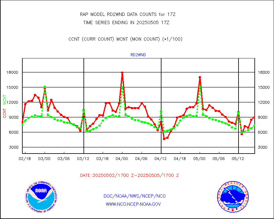
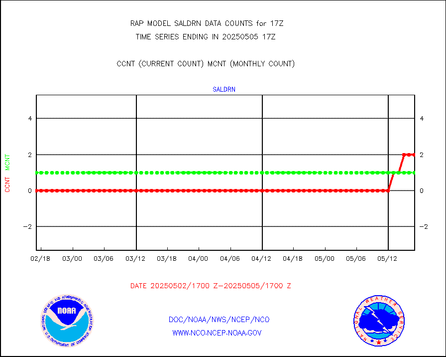
Surface Marine Saildrone (decoded from BUFR) |
2 |
2 |
100.0 % |
0315.00-0318.99 |
||||||||||
Megha-Tropiques SAPHIR L1A2 brightness temps |
0 |
0 |
n/a |
0314.00-0319.99 |
||||||||||
METEOSAT-10 2nd Gen SEVIRI All Sky Radiance(proc) |
9512 |
9148 |
104.0 % |
0315.00-0318.99 |
||||||||||
METEOSAT-10 2nd Gen SEVIRI Clr Sky Radiance(proc) |
0 |
0 |
n/a |
0315.00-0318.99 |
||||||||||
Ship - manual and automatic, restricted |
12 |
13 |
92.3 % |
0316.50-0317.50 |
||||||||||
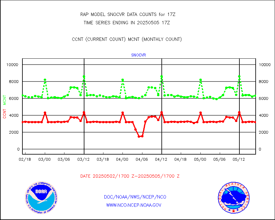
NOW COVER, DEPTH/DENSITY AND WATER EQUIVALENT |
3137 |
6182 |
50.7 % |
0315.00-0319.00 |
||||||||||
DMSP SSM/IS 1C radiance data (Unified Pre-Proc.) |
46760 |
53773 |
87.0 % |
0315.00-0318.99 |
||||||||||
Sub-surface float and glider profile (BUFR) |
3 |
4 |
75.0 % |
0315.00-0318.99 |
||||||||||
Synoptic - restricted (WMO Res 40) manual & auto. |
0 |
0 |
n/a |
0316.50-0317.50 |
||||||||||
Synoptic - restricted (WMO Res 40)(decoded BUFR) |
289 |
326 |
88.7 % |
0316.50-0317.50 |
||||||||||
Synoptic - mobile manual & auto (decoded fr BUFR) |
0 |
0 |
n/a |
0316.50-0317.50 |
||||||||||
TAMDAR aircft data-all types(from Panasonic,BUFR) |
156 |
204 |
76.5 % |
0313.75-0320.25 |
||||||||||
MTSAT/JMA visible derived cloud motion |
0 |
0 |
n/a |
0314.50-0319.50 |
||||||||||
GOES-16&up/NESDIS visible derived cloud motion |
145767 |
146116 |
99.8 % |
0316.00-0316.99 |
||||||||||
METEOSAT/EUMETSAT visible drv cld motion NBseq |
6358 |
6461 |
98.4 % |
0315.50-0318.49 |
||||||||||


