| Suspect Data Shortages in Critical Types - Monitor | ||||||||||||||
|---|---|---|---|---|---|---|---|---|---|---|---|---|---|---|
| Type | Description | Hourly Count | Monthly Average | Percent (%) of Monthly Mean | UTC Time Window | |||||||||
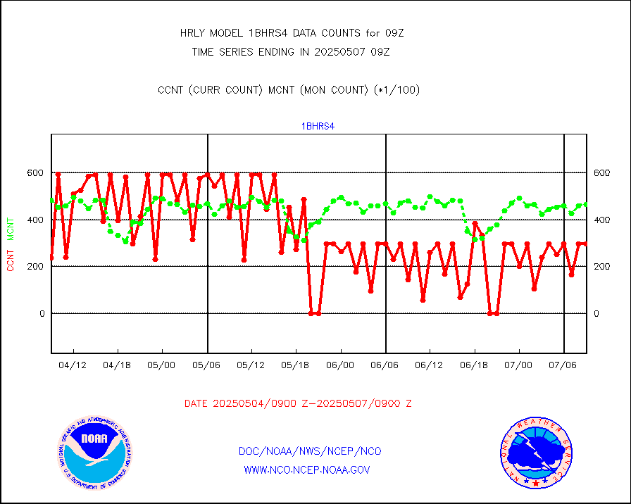
NOAA 18-19 & METOP 1-2 HIRS-4 NCEP-proc. br.temps |
0 |
13736 |
0.0 % |
0107.00-0107.99 |
||||||||||
NOAA 15-19 & METOP 1-2 HIRS-3/4 pr btmps frm RARS |
0 |
5263 |
0.0 % |
0108.50-0109.49 |
||||||||||
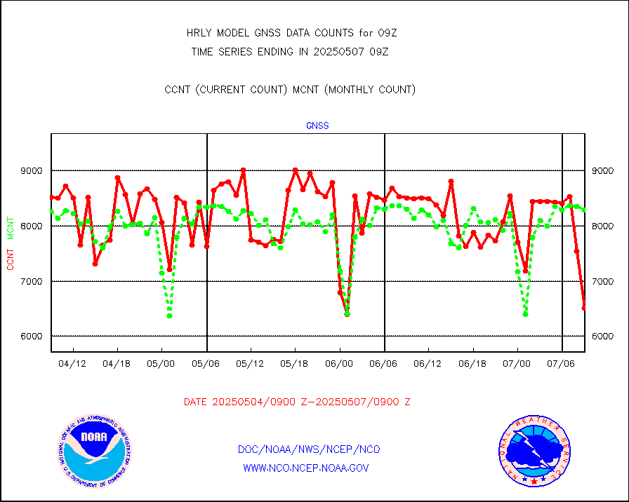
Grnd-based Gbl Navigation Sat System (GNSS) data |
1380 |
6917 |
20.0 % |
0108.00-0108.99 |
||||||||||
| Shortage in Data Type of Opportunity - Monitor | ||||||||||||||
|---|---|---|---|---|---|---|---|---|---|---|---|---|---|---|
| Type | Description | Hourly Count | Monthly Average | Percent (%) of Monthly Mean | UTC Time Window | |||||||||
P.M.(N18-19) AVHRR GAC NCEP-proc clr & sea btemps |
0 |
485397 |
0.0 % |
0106.50-0107.49 |
||||||||||
METOP 1-2 IASI 1C radiance data vbl chn from RARS |
0 |
2144 |
0.0 % |
0108.00-0108.99 |
||||||||||
INDIA SATWIND, INSAT WV channel |
0 |
234 |
0.0 % |
0108.00-0108.99 |
||||||||||
INDIA SATWIND, INSAT IR channel |
0 |
308 |
0.0 % |
0108.00-0108.99 |
||||||||||
Ship - manual and automatic, restricted |
1 |
13 |
7.7 % |
0108.50-0109.49 |
||||||||||
INDIA SATWIND, INSAT VIS channel |
0 |
15 |
0.0 % |
0108.00-0108.99 |
||||||||||
| Critical Data with Normal Counts | ||||||||||||||
|---|---|---|---|---|---|---|---|---|---|---|---|---|---|---|
| Type | Description | Hourly Count | Monthly Average | Percent (%) of Monthly Mean | UTC Time Window | |||||||||
NOAA 15-19 & METOP 1-2 AMSU-A NCEP-proc. br.temps |
26736 |
34515 |
77.5 % |
0107.00-0107.99 |
||||||||||
NOAA 18-19 & METOP 1-2 MHS NCEP-proces. br. temps |
239135 |
253662 |
94.3 % |
0107.00-0107.99 |
||||||||||
MDCRS ACARS acft data from ARINC(dcded from BUFR) |
8267 |
11301 |
73.2 % |
0108.50-0109.49 |
||||||||||
Manual AIREP aircraft data (dcded from AIREP fmt) |
553 |
530 |
104.3 % |
0108.50-0109.49 |
||||||||||
AQUA AIRS/AMSU-A/HSB brightness temps- every FOV |
0 |
0 |
n/a |
0106.50-0107.49 |
||||||||||
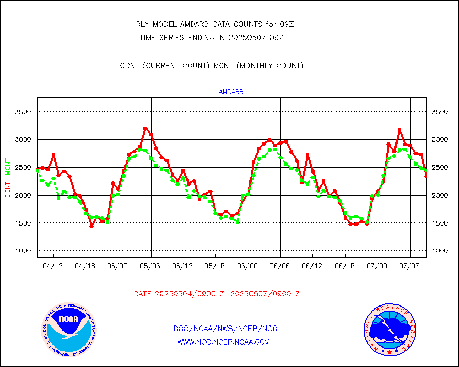
AMDAR aircraft data (decoded from AMDAR format) |
340 |
262 |
129.8 % |
0108.50-0109.49 |
||||||||||
AMDAR aircraft data (decoded from BUFR) |
2348 |
2493 |
94.2 % |
0108.50-0109.49 |
||||||||||
METOP 1-2 ASCAT products |
62874 |
60262 |
104.3 % |
0107.50-0108.49 |
||||||||||
NPP/NOAA-20 ATMS brightness temperatures |
327360 |
351302 |
93.2 % |
0107.50-0108.49 |
||||||||||
Canadian AMDAR aircraft data (decoded from BUFR) |
0 |
0 |
n/a |
0108.50-0109.49 |
||||||||||
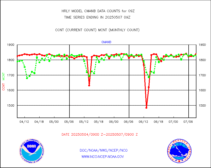
Surface Marine CMAN rpts decoded from BUFR format |
1873 |
1867 |
100.3 % |
0108.50-0109.50 |
||||||||||
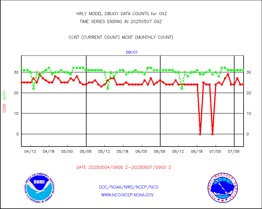
Buoys decoded from FM-18 fmt (moored or drifting) |
13 |
19 |
68.4 % |
0108.50-0109.49 |
||||||||||
E-AMDAR (European AMDAR acft decoded from BUFR) |
2090 |
2273 |
91.9 % |
0108.50-0109.49 |
||||||||||
NOAA 15-19 & METOP 1-2 AMSU-A proc btmps frm RARS |
4080 |
8150 |
50.1 % |
0108.50-0109.49 |
||||||||||
GPS radio occultation data |
467 |
497 |
94.0 % |
0106.50-0107.49 |
||||||||||
GOES-16/17 All Sky Radiances (proc.) |
720952 |
720952 |
100.0 % |
0108.50-0109.49 |
||||||||||
GOES-16/17 Clear Sky Radiances (proc.) |
344080 |
346834 |
99.2 % |
0108.50-0109.49 |
||||||||||
MTSAT/JMA water vapor imager derived cloud motion |
21915 |
19490 |
112.4 % |
0106.50-0107.49 |
||||||||||
MODIS (AQUA/TERRA) wvpr imager derived cld motion |
0 |
0 |
n/a |
0105.00-0105.99 |
||||||||||
GOES-16&up/NESDIS wv imgr/cld-top derived cld mtn |
23406 |
25235 |
92.8 % |
0108.00-0108.99 |
||||||||||
METEOSAT/EUMETSAT ir lg-wave drv cld motion NBseq |
21020 |
20834 |
100.9 % |
0107.50-0108.49 |
||||||||||
MTSAT/JMA infrared long-wave derived cloud motion |
16800 |
16029 |
104.8 % |
0106.50-0107.49 |
||||||||||
MODIS (AQUA/TERRA) ir l-wave derived cloud motion |
0 |
0 |
n/a |
0105.00-0105.99 |
||||||||||
GOES-16&up/NESDIS ir long-wave derived cld motion |
82802 |
83735 |
98.9 % |
0108.00-0108.99 |
||||||||||
GOES/NASA(Langley) hi-res. (1x1 f-o-v) cloud data |
6441726 |
6446610 |
99.9 % |
0108.50-0109.49 |
||||||||||
Buoys decoded from FM-13 format (moored) |
123 |
123 |
100.0 % |
0108.50-0109.49 |
||||||||||
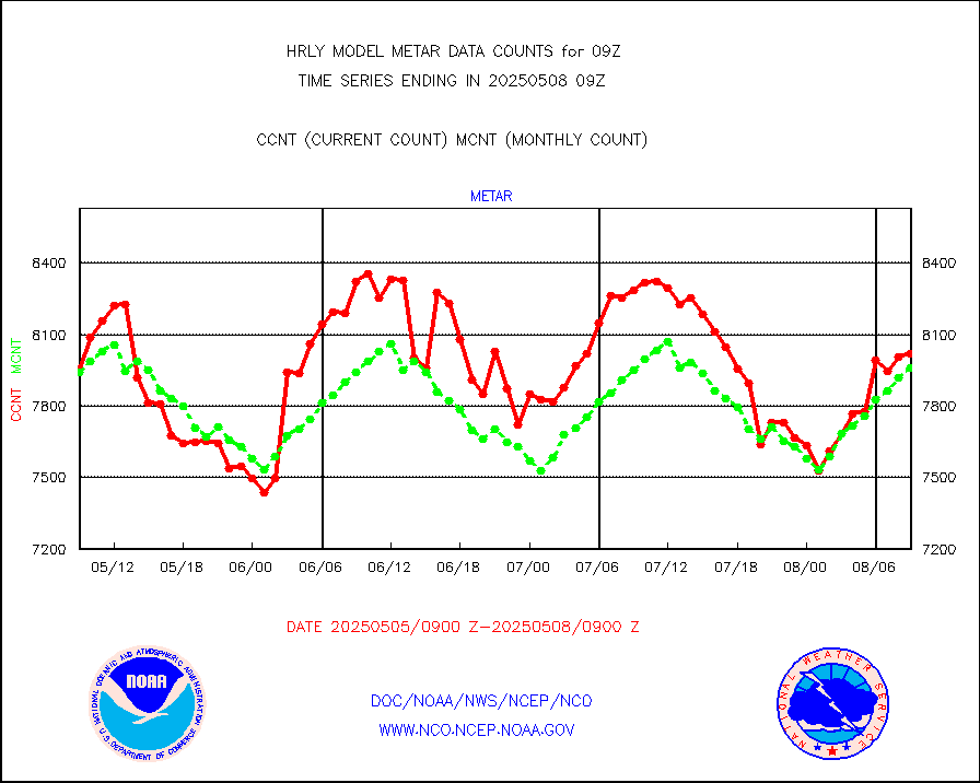
Aviation - METAR |
8006 |
7983 |
100.3 % |
0108.50-0109.49 |
||||||||||
Mesonet/MADIS Colorado E-470 (Interstate 470) |
24 |
24 |
100.0 % |
0108.50-0109.49 |
||||||||||
Mesonet/MADIS Alaska Department of Transportation |
117 |
89 |
131.5 % |
0108.50-0109.49 |
||||||||||
Mesonet/MADIS U.S. Army Aberdeen Proving Grounds |
0 |
0 |
n/a |
0108.50-0109.49 |
||||||||||
Mesonet/MADIS Citizen Weather Observers Program |
15873 |
60190 |
26.4 % |
0108.50-0109.49 |
||||||||||
Mesonet/MADIS AWS Convergence Technologies, Inc. |
5957 |
19934 |
29.9 % |
0108.50-0109.49 |
||||||||||
Mesonet/MADIS "Anything Weather" |
0 |
0 |
n/a |
0108.50-0109.49 |
||||||||||
Mesonet/MADIS Colorado Dept. of Transportation |
0 |
0 |
n/a |
0108.50-0109.49 |
||||||||||
Mesonet/MADIS DC Net |
0 |
0 |
n/a |
0108.50-0109.49 |
||||||||||
Mesonet/MADIS Denver Urban Drainage & Flood Cntrl |
0 |
0 |
n/a |
0108.50-0109.49 |
||||||||||
Mesonet/MADIS Florida (FAWN & USF) |
4 |
4 |
100.0 % |
0108.50-0109.49 |
||||||||||
Mesonet/MADIS Florida Dept. of Transportation |
0 |
0 |
n/a |
0108.50-0109.49 |
||||||||||
Mesonet/MADIS Georgia Dept. of Transportation |
0 |
0 |
n/a |
0108.50-0109.49 |
||||||||||
Mesonet/MADIS NWS Hydromet Auto Data System(HADS) |
5863 |
6109 |
96.0 % |
0108.50-0109.49 |
||||||||||
Mesonet/MADIS Iowa Environmental |
194 |
183 |
106.0 % |
0108.50-0109.49 |
||||||||||
Mesonet/MADIS Indiana Dept. of Transportation |
0 |
0 |
n/a |
0108.50-0109.49 |
||||||||||
Mesonet/MADIS Iowa Department of Transportation |
0 |
0 |
n/a |
0108.50-0109.49 |
||||||||||
Mesonet/MADIS Kansas Department of Transportation |
330 |
348 |
94.8 % |
0108.50-0109.49 |
||||||||||
Mesonet/MADIS Oklahoma Mesonet |
630 |
623 |
101.1 % |
0108.50-0109.49 |
||||||||||
Mesonet/MADIS Louisiana State/Jackson State Univ. |
0 |
0 |
n/a |
0108.50-0109.49 |
||||||||||
Mesonet/MADIS Missouri Commercial Agricult Wx Net |
333 |
333 |
100.0 % |
0108.50-0109.49 |
||||||||||
Mesonet/MADIS Minnesota Dept. of Transportation |
0 |
0 |
n/a |
0108.50-0109.49 |
||||||||||
Mesonet/MADIS NOS-Phys Oceanographic Realtime Sys |
376 |
380 |
98.9 % |
0108.50-0109.49 |
||||||||||
Mesonet/MADIS NFIC Remote Automated Wx Stns(RAWS) |
1927 |
1832 |
105.2 % |
0108.50-0109.49 |
||||||||||
Mesonet/MADIS many providers, not separated out |
16322 |
71274 |
22.9 % |
0108.00-0109.49 |
||||||||||
Mesonet/MADIS Virginia Dept. of Transportation |
0 |
0 |
n/a |
0108.50-0109.49 |
||||||||||
Mesonet/MADIS "Weather for You" |
0 |
0 |
n/a |
0108.50-0109.49 |
||||||||||
Mesonet/MADIS Wisconsin Dept. of Transportation |
0 |
0 |
n/a |
0108.50-0109.49 |
||||||||||
Mesonet/MADIS MesoWest (many subproviders) |
7261 |
35187 |
20.6 % |
0108.50-0109.49 |
||||||||||
Mesonet/MADIS West Texas |
5863 |
6031 |
97.2 % |
0108.50-0109.49 |
||||||||||
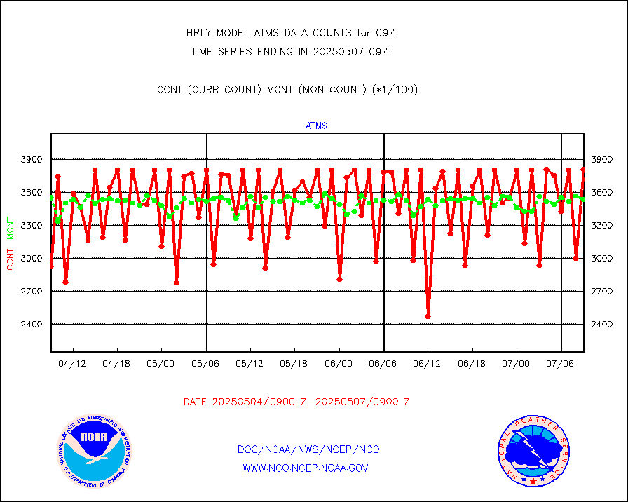
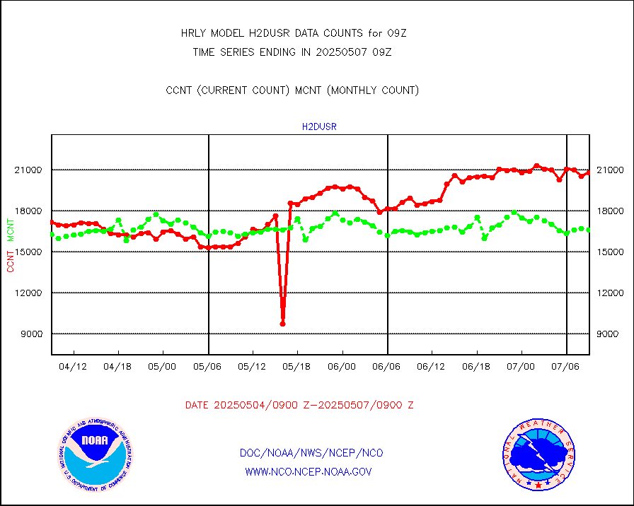
METOP 1-2 IASI 1C radiance data (varbl. channels) |
106924 |
81184 |
131.7 % |
0107.00-0107.99 |
||||||||||
NEXRAD Vel Azm Dsp(VAD) winds via radar coded msg |
0 |
0 |
n/a |
0108.50-0109.49 |
||||||||||
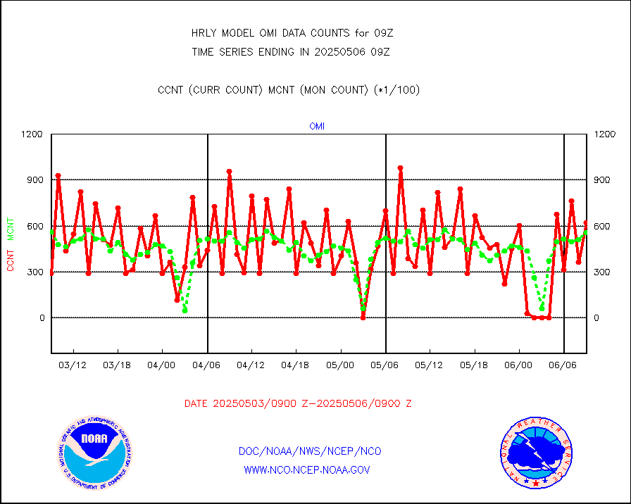
Aura Ozone Monitoring Instrument (OMI) data |
0 |
0 |
n/a |
0106.50-0107.49 |
||||||||||
NOAA 16-19 Solar Backscatter UV-2 rad frm V8 BUFR |
0 |
0 |
n/a |
0107.00-0107.99 |
||||||||||
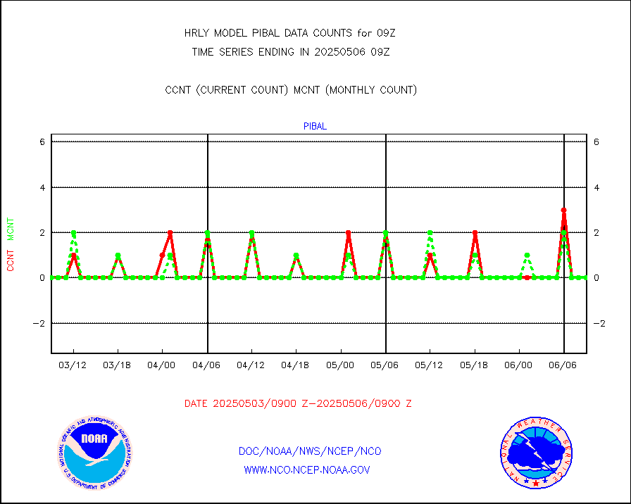
PIBAL (from PILOT, PILOT SHIP, PILOT MOBIL) |
0 |
0 |
n/a |
0108.50-0109.49 |
||||||||||
Multi-Agency Profiler (MAP) and SODAR winds |
46 |
48 |
95.8 % |
0108.50-0109.49 |
||||||||||
Rawinsonde - fixed land (from TEMP or PILOT) |
0 |
0 |
n/a |
0108.50-0109.49 |
||||||||||
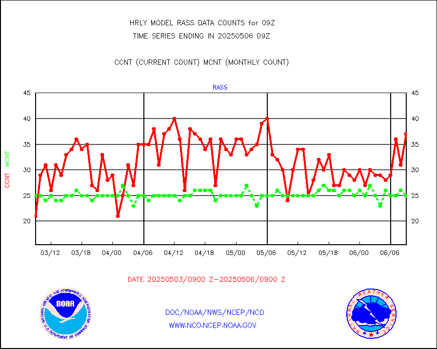
RASS temperatures (NOAA and Multi-Agency) |
21 |
26 |
80.8 % |
0108.50-0109.49 |
||||||||||
NEXRAD reflectivity (Lvl 2 - GTS) |
4115307 |
4065192 |
101.2 % |
0108.50-0109.49 |
||||||||||
NEXRAD radial wind (Level 2 - GTS) |
2083445 |
1611943 |
129.3 % |
0108.50-0109.49 |
||||||||||
METEOSAT-10 2nd Gen SEVIRI Clr Sky Radiance(proc) |
0 |
0 |
n/a |
0108.50-0109.49 |
||||||||||
Ship - manual and automatic, restricted (BUFR) |
19 |
8 |
237.5 % |
0108.50-0109.50 |
||||||||||
Ship - manual and automatic, unrestricted |
183 |
188 |
97.3 % |
0108.50-0109.50 |
||||||||||
Ship - manual and automatic, unrestricted (BUFR) |
610 |
583 |
104.6 % |
0108.50-0109.50 |
||||||||||
Synoptic - fixed manual and automatic |
1631 |
1632 |
99.9 % |
0108.50-0109.49 |
||||||||||
Synoptic - fixed manual & auto (decoded fr BUFR) |
6324 |
6316 |
100.1 % |
0108.50-0109.49 |
||||||||||
Synoptic - restricted (WMO Res 40) manual & auto. |
1 |
5 |
20.0 % |
0108.50-0109.49 |
||||||||||
Synoptic - restricted (WMO Res 40)(decoded BUFR) |
358 |
370 |
96.8 % |
0108.50-0109.49 |
||||||||||
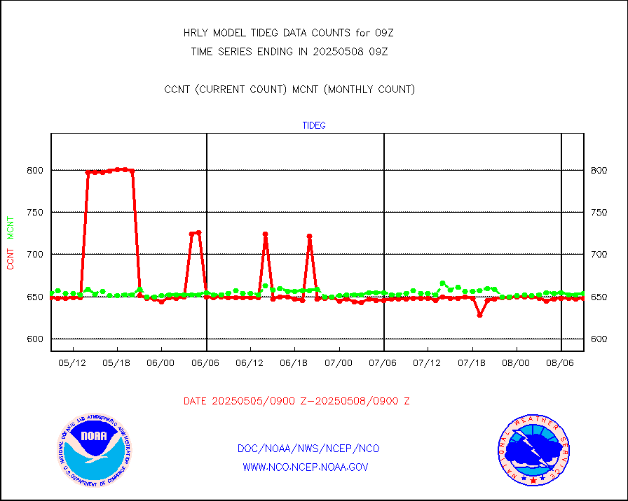
Tide gauge reports decoded from CREX format |
658 |
656 |
100.3 % |
0108.00-0108.99 |
||||||||||
| Data Types of Opportunity with Normal Counts | ||||||||||||||
|---|---|---|---|---|---|---|---|---|---|---|---|---|---|---|
| Type | Description | Hourly Count | Monthly Average | Percent (%) of Monthly Mean | UTC Time Window | |||||||||
GOES-16&up/NESDIS ir short-wv derived cld motion |
46643 |
47269 |
98.7 % |
0108.00-0108.99 |
||||||||||
MDCRS ACARS acft data (ARINC via AFWA)(AIREP fmt) |
0 |
0 |
n/a |
0108.50-0109.49 |
||||||||||
Himawari Clear Sky Radiance |
0 |
0 |
n/a |
0108.00-0108.99 |
||||||||||
GCOM-W AMSR2 1B brightness temperatures |
2309472 |
2088958 |
110.6 % |
0107.00-0107.99 |
||||||||||
NPP/NOAA-20 ATMS bright. temps-direct b-cast SSEC |
127475 |
90431 |
141.0 % |
0107.50-0108.49 |
||||||||||
POES/NESDIS - processed ATOVS soundings/radiances |
0 |
0 |
n/a |
0107.00-0107.99 |
||||||||||
A.M.(N17,M2,M3) AVHRR GAC NCEP-proc clr&sea btmps |
1164122 |
1185031 |
98.2 % |
0106.50-0107.49 |
||||||||||
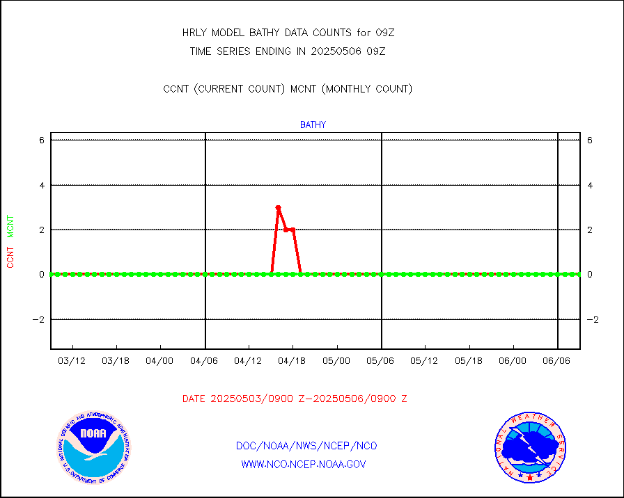
eXpendable BathyThermograph, mooring (BATHY fmt) |
0 |
0 |
n/a |
0102.00-0102.99 |
||||||||||
Coop/MADIS NEPP & HCN-Modernization NOAA COOP Obs |
11 |
11 |
100.0 % |
0108.50-0109.49 |
||||||||||
NPP/NOAA-20 CrIS full spctrl radn (431 ch subset) |
240534 |
235010 |
102.4 % |
0107.50-0108.49 |
||||||||||
NPP/NOAA-20 CrIS full spctrl radn dir brdcst SSEC |
41040 |
39037 |
105.1 % |
0107.50-0108.49 |
||||||||||
Coast Guard |
5 |
6 |
83.3 % |
0108.50-0109.50 |
||||||||||
Drifting buoys (decoded from BUFR) |
1415 |
1435 |
98.6 % |
0108.50-0109.50 |
||||||||||
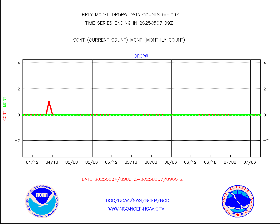
Dropwinsonde (from TEMP DROP) |
0 |
0 |
n/a |
0108.50-0109.49 |
||||||||||
Dropwinsonde (decoded from BUFR) |
0 |
0 |
n/a |
0108.51-0109.49 |
||||||||||
GOES imager effective cloud amount data (U.Wisc.) |
9250602 |
8277873 |
111.8 % |
0108.50-0109.49 |
||||||||||
NPP Adv. Tech. MW Sndr (ATMS) br. temps from RARS |
10368 |
4787 |
216.6 % |
0107.50-0108.49 |
||||||||||
NOAA 18-19 & METOP 1-2 MHS proc. btemps from RARS |
37620 |
78220 |
48.1 % |
0108.50-0109.49 |
||||||||||
GOES/NESDIS (11x17 f-o-v) imager clear radiances |
0 |
0 |
n/a |
0108.00-0108.99 |
||||||||||
METOP 1-2 Global Ozone Monitoring Exp.-2 (GOME-2) |
9453 |
9793 |
96.5 % |
0107.50-0108.49 |
||||||||||
GOES-16&up/NESDIS wv imgr/deep-lyr derivd cld mtn |
19735 |
17056 |
115.7 % |
0108.00-0108.99 |
||||||||||
METEOSAT/EUMETSAT wvpr imgr drv cld motion NBseq |
35369 |
36869 |
95.9 % |
0107.50-0108.49 |
||||||||||
High Density OBs from reconnaissance acft data |
0 |
4 |
0.0 % |
0108.50-0109.49 |
||||||||||
METOP 1-2 IASI 1C radiances-direct broadcast SSEC |
23520 |
28366 |
82.9 % |
0107.50-0108.49 |
||||||||||
VIIRS (NPP/NOAA-20) ir lg-wv drv cloud motion(NB) |
24105 |
20378 |
118.3 % |
0105.00-0105.99 |
||||||||||
AVHRR (NOAA/METOP) ir lg-wave derived cld motion |
0 |
0 |
n/a |
0105.00-0105.99 |
||||||||||
AVHRR (METOP) ir lg-wave derived cld motion |
0 |
0 |
n/a |
0108.50-0109.50 |
||||||||||
INSAT/KALPANA India ir lg-wave derived cld motion |
0 |
0 |
n/a |
0106.50-0107.49 |
||||||||||
Korean AMDAR aircraft data (decoded from BUFR) |
116 |
98 |
118.4 % |
0108.50-0109.49 |
||||||||||
Land-based CMAN stations decoded from CMAN format |
68 |
84 |
81.0 % |
0108.50-0109.49 |
||||||||||
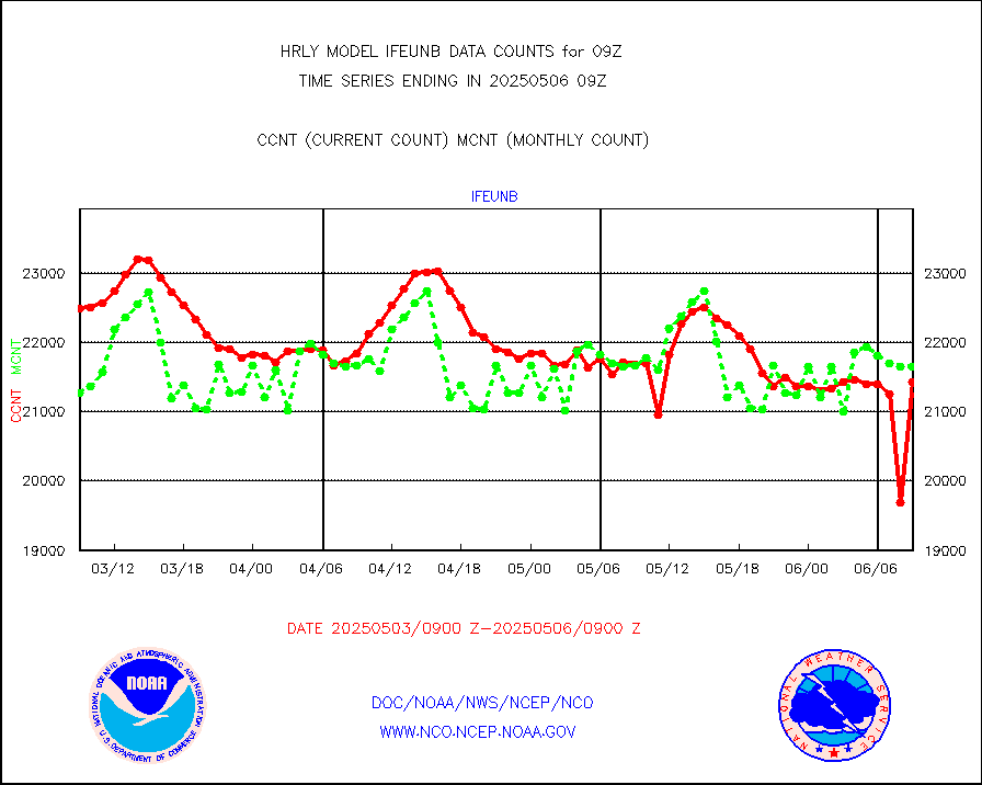
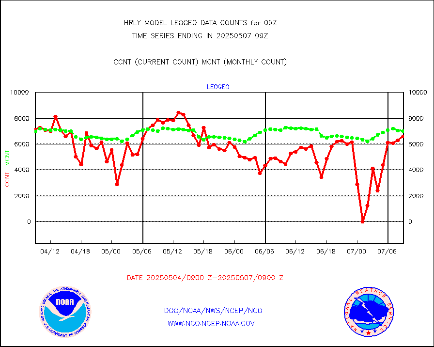
LEO-GEO satellite AMVs from UWisc. |
7215 |
7832 |
92.1 % |
0105.00-0105.99 |
||||||||||
LLDN Long-rng lightning from Vaisala via NOAAPORT |
161898 |
135728 |
119.3 % |
0108.50-0109.49 |
||||||||||
NLDN Shrt-rng lightning from Vaisala via NOAAPORT |
3876 |
4094 |
94.7 % |
0108.50-0109.49 |
||||||||||
Moored buoys (decoded from BUFR) |
975 |
929 |
105.0 % |
0108.50-0109.50 |
||||||||||
Aura Microwave Limb Sounder (MLS) ozone data |
0 |
0 |
n/a |
0107.00-0107.99 |
||||||||||
Mesonet/MADIS UrbaNet |
3578 |
3540 |
101.1 % |
0108.50-0109.49 |
||||||||||
NEXRAD Vel Azm Dsp(VAD) winds via Level 2 decoder |
552 |
534 |
103.4 % |
0108.50-0109.49 |
||||||||||
OMPS Limb Profiler ozone data (NPP) |
283 |
254 |
111.4 % |
0102.00-0102.99 |
||||||||||
OMPS nadir profile ozone (Version 8 BUFR) |
610 |
558 |
109.3 % |
0107.00-0107.99 |
||||||||||
OMPS total column ozone (Version 8 BUFR) |
508149 |
335217 |
151.6 % |
0107.00-0107.99 |
||||||||||
PIBAL (decoded from BUFR) |
0 |
0 |
n/a |
0108.51-0109.49 |
||||||||||
Manual PIREP aircraft data (dcded from AIREP fmt) |
3 |
10 |
30.0 % |
0108.50-0109.49 |
||||||||||
Profilr winds from PIBAL (PILOT,PILOT SHIP/MOBIL) |
0 |
0 |
n/a |
0108.50-0109.49 |
||||||||||
Rawinsonde - fixed land (decoded from BUFR) |
1 |
0 |
n/a |
0108.51-0109.49 |
||||||||||
Rawinsonde - mobile land (from TEMP/PILOT MOBIL) |
0 |
0 |
n/a |
0108.50-0109.49 |
||||||||||
Rawinsonde - mobile land (decoded from BUFR) |
0 |
0 |
n/a |
0108.51-0109.49 |
||||||||||
Rawinsonde - ship (from TEMP SHIP, PILOT SHIP) |
0 |
0 |
n/a |
0108.50-0109.49 |
||||||||||
Rawinsonde - ship (decoded from BUFR) |
0 |
0 |
n/a |
0108.51-0109.49 |
||||||||||
Flight level reconnaissance aircraft data |
0 |
0 |
n/a |
0108.50-0109.49 |
||||||||||
Megha-Tropiques SAPHIR L1A2 brightness temps |
0 |
0 |
n/a |
0106.50-0107.49 |
||||||||||
METEOSAT-10 2nd Gen SEVIRI All Sky Radiance(proc) |
75512 |
75467 |
100.1 % |
0108.50-0109.49 |
||||||||||
DMSP SSM/IS 1C radiance data (Unified Pre-Proc.) |
0 |
96972 |
0.0 % |
0107.50-0108.49 |
||||||||||
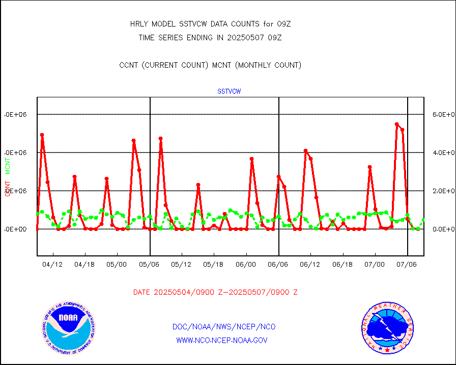
NPP/NOAA-20 VIIRS SST - CLEAR & OVER WATER |
0 |
2125275 |
0.0 % |
0108.50-0109.49 |
||||||||||
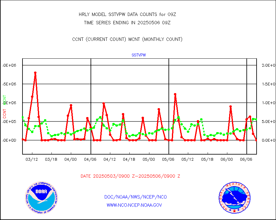
NPP/NOAA-20 VIIRS SST - PROBABLY CLR & OVER WATER |
0 |
488748 |
0.0 % |
0108.50-0109.49 |
||||||||||
Synoptic - mobile manual and automatic |
736 |
698 |
105.4 % |
0108.50-0109.49 |
||||||||||
Synoptic - mobile manual & auto (decoded fr BUFR) |
1 |
1 |
100.0 % |
0108.50-0109.49 |
||||||||||
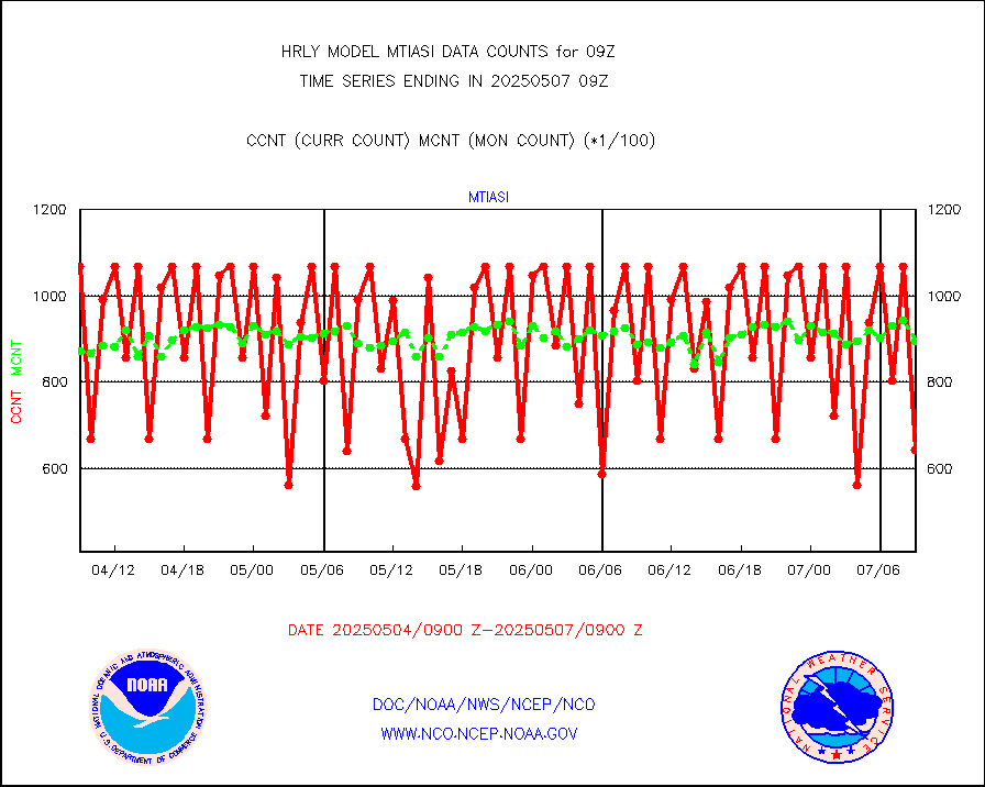
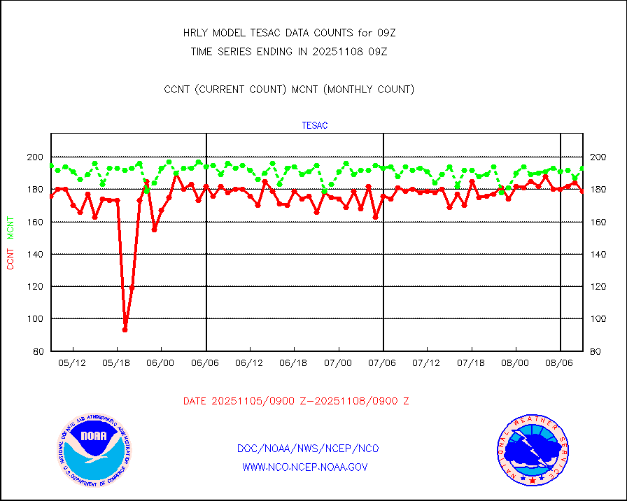
CTD probe, Argo prflng float, mooring (TESAC fmt) |
227 |
215 |
105.6 % |
0108.50-0109.49 |
||||||||||
TAMDAR aircft data-all types(from Panasonic,BUFR) |
57 |
50 |
114.0 % |
0108.50-0109.49 |
||||||||||
ThermoSalinoGraph (TSG) TRACKOB format) |
91 |
88 |
103.4 % |
0107.50-0108.49 |
||||||||||
INSAT/KALPANA India visible derived cloud motion |
0 |
0 |
n/a |
0106.50-0107.49 |
||||||||||
MTSAT/JMA visible derived cloud motion |
7906 |
6697 |
118.1 % |
0106.50-0107.49 |
||||||||||
GOES-16&up/NESDIS visible derived cloud motion |
4812 |
7272 |
66.2 % |
0108.00-0108.99 |
||||||||||
METEOSAT/EUMETSAT visible drv cld motion NBseq |
39142 |
38541 |
101.6 % |
0107.50-0108.49 |
||||||||||


