| Critical Data with Normal Counts | ||||||||||||||
|---|---|---|---|---|---|---|---|---|---|---|---|---|---|---|
| Type | Description | Hourly Count | Monthly Average | Percent (%) of Monthly Mean | UTC Time Window | |||||||||
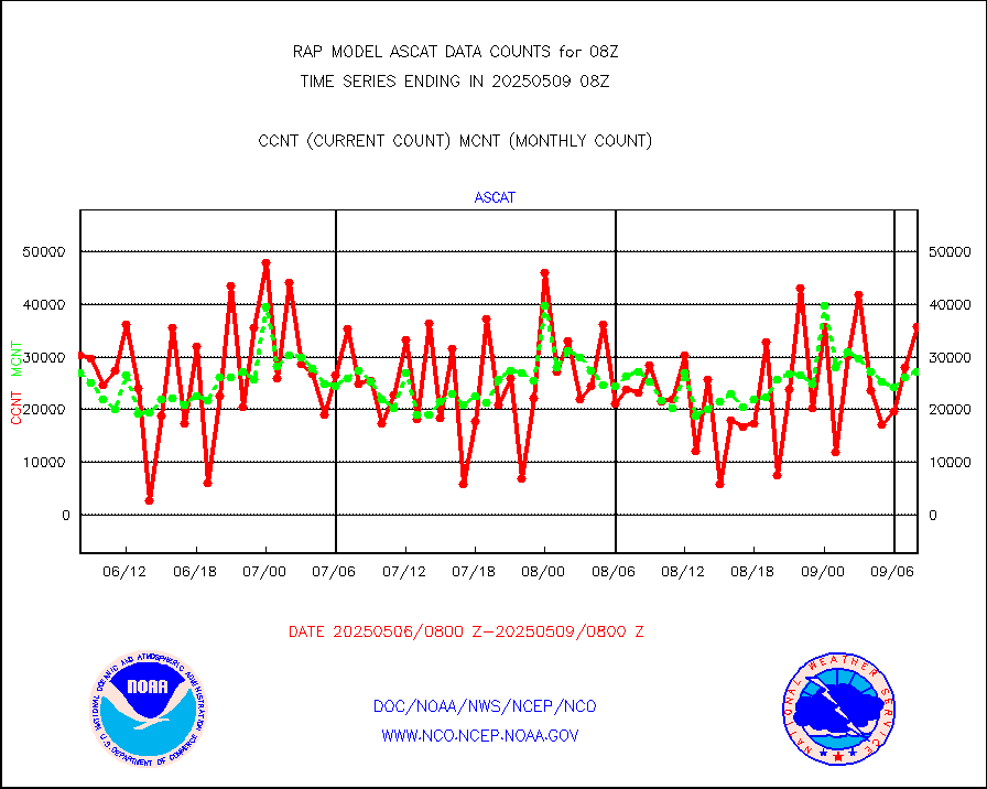
NOAA 15-19 & METOP 1-2 AMSU-A NCEP-proc. br.temps |
49560 |
43027 |
115.2 % |
2305.00-2310.99 |
||||||||||
NOAA 18-19 & METOP 1-2 HIRS-4 NCEP-proc. br.temps |
25607 |
26400 |
97.0 % |
2305.00-2310.99 |
||||||||||
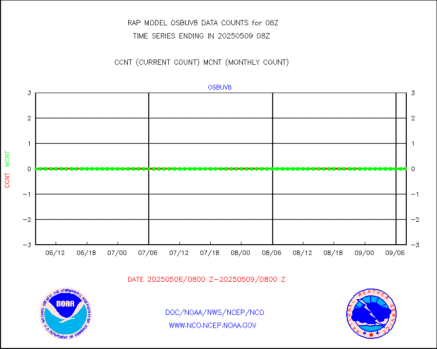
NOAA 18-19 & METOP 1-2 MHS NCEP-proces. br. temps |
265593 |
243426 |
109.1 % |
2305.00-2310.99 |
||||||||||
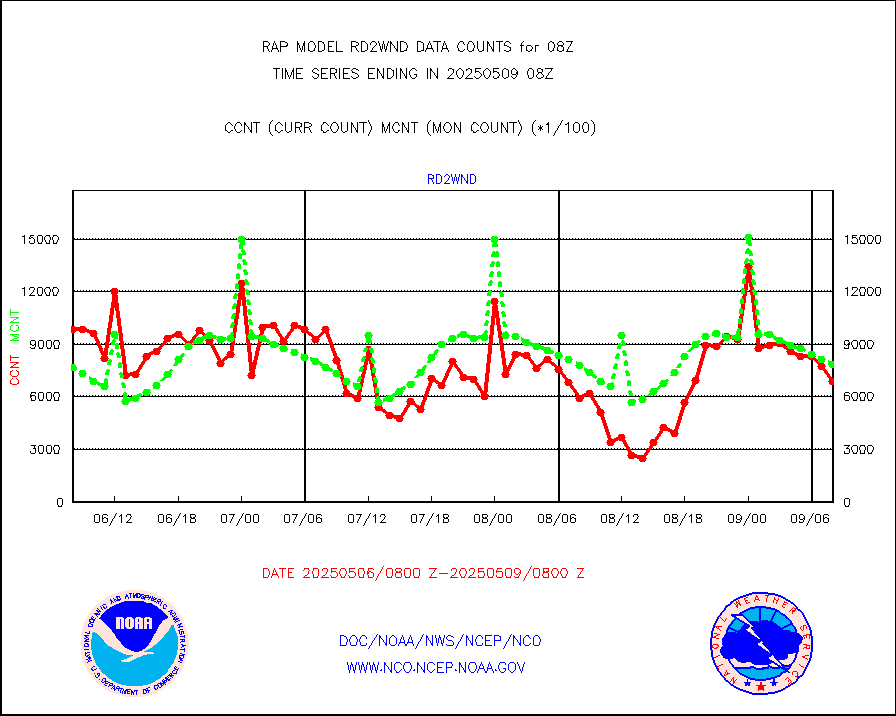
MDCRS ACARS acft data from ARINC(dcded from BUFR) |
39362 |
40019 |
98.4 % |
2304.75-2311.25 |
||||||||||
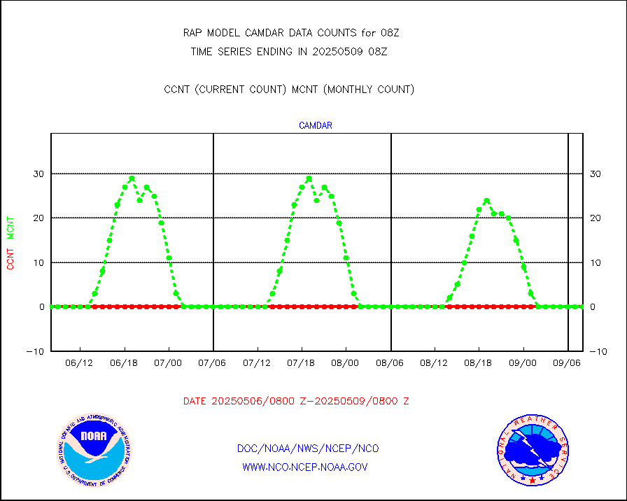
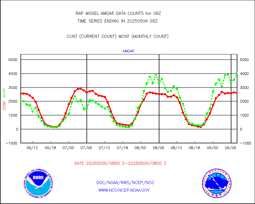
Canadian AMDAR aircraft data (decoded from BUFR) |
0 |
0 |
n/a |
2304.75-2311.25 |
||||||||||
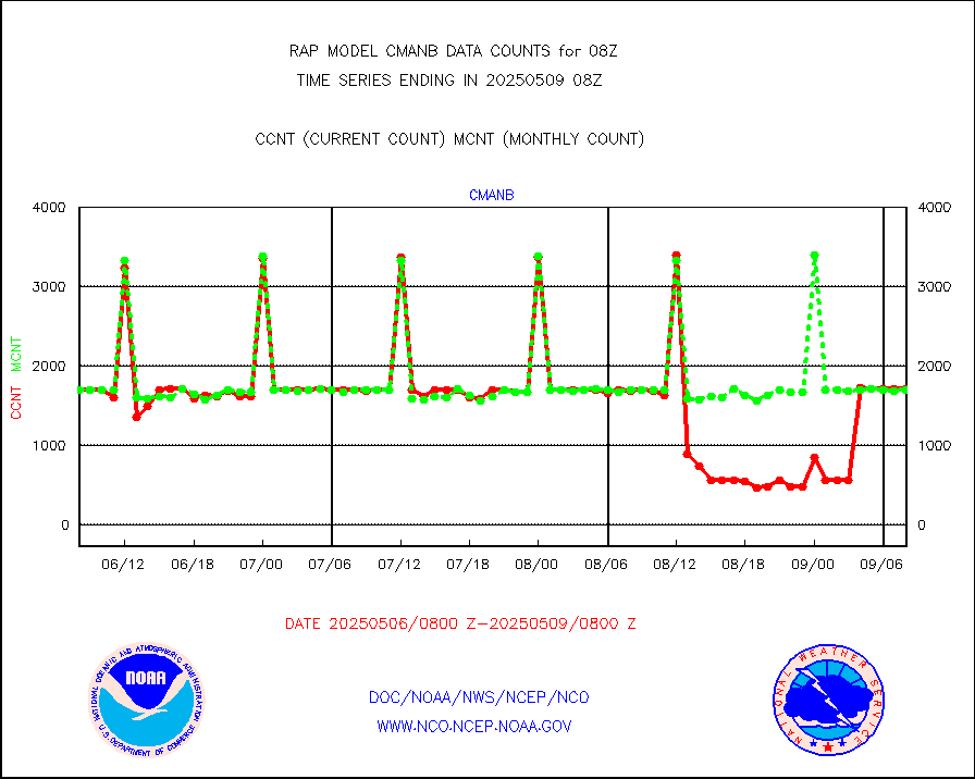
Surface Marine CMAN rpts decoded from BUFR format |
1709 |
1696 |
100.8 % |
2307.50-2308.50 |
||||||||||
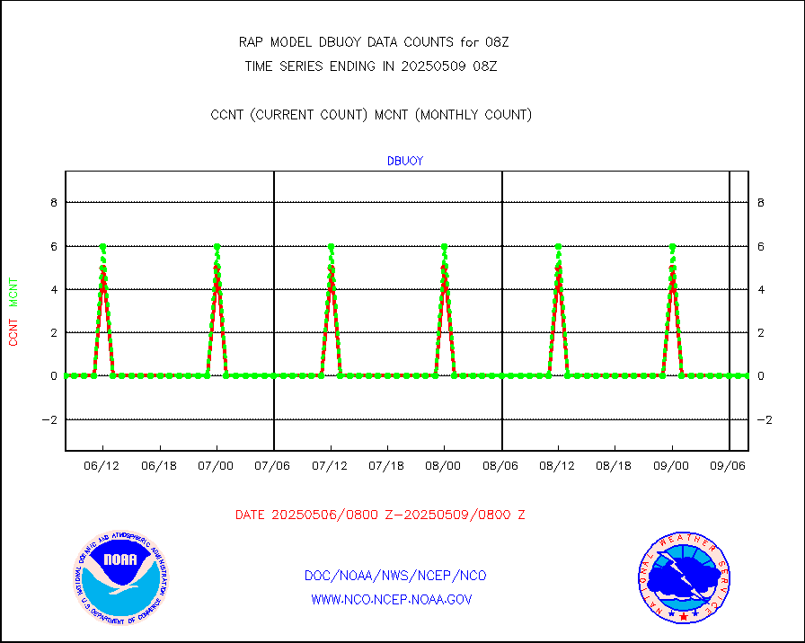
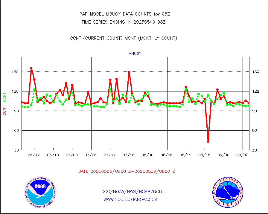
Buoys decoded from FM-18 fmt (moored or drifting) |
0 |
0 |
n/a |
2307.50-2308.50 |
||||||||||
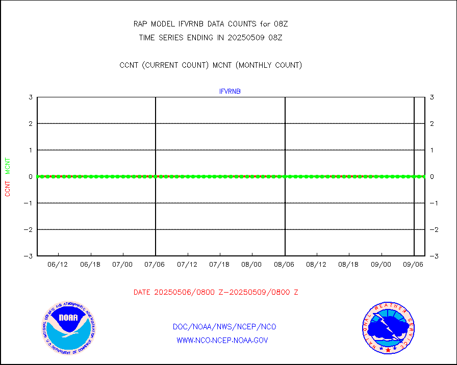
Grnd-based Gbl Navigation Sat System (GNSS) data |
2624 |
2577 |
101.8 % |
2306.95-2307.05 |
||||||||||
MODIS (AQUA/TERRA) wvpr imager derived cld motion |
0 |
0 |
n/a |
2305.50-2310.50 |
||||||||||
MODIS (AQUA/TERRA) ir l-wave derived cloud motion |
0 |
0 |
n/a |
2305.50-2310.50 |
||||||||||
GOES/NASA(Langley) hi-res. (1x1 f-o-v) cloud data |
1865812 |
1743115 |
107.0 % |
2307.50-2308.50 |
||||||||||
Buoys decoded from FM-13 format (moored) |
109 |
102 |
106.9 % |
2307.50-2308.50 |
||||||||||
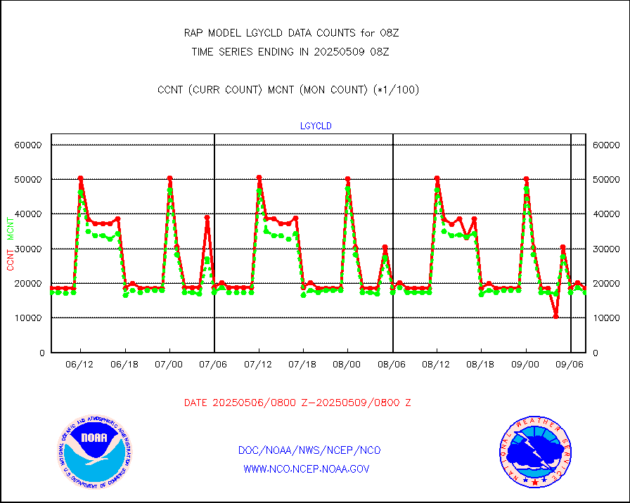
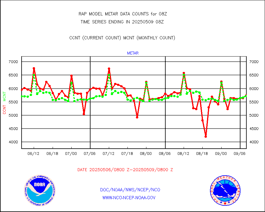
Aviation - METAR |
5750 |
5775 |
99.6 % |
2307.50-2308.50 |
||||||||||
NEXRAD Vel Azm Dsp(VAD) winds via radar coded msg |
0 |
0 |
n/a |
2307.00-2309.00 |
||||||||||
Multi-Agency Profiler (MAP) and SODAR winds |
80 |
93 |
86.0 % |
2306.50-2309.50 |
||||||||||
Rawinsonde - fixed land (from TEMP or PILOT) |
2 |
1 |
200.0 % |
2307.00-2309.00 |
||||||||||
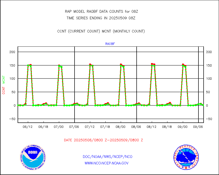
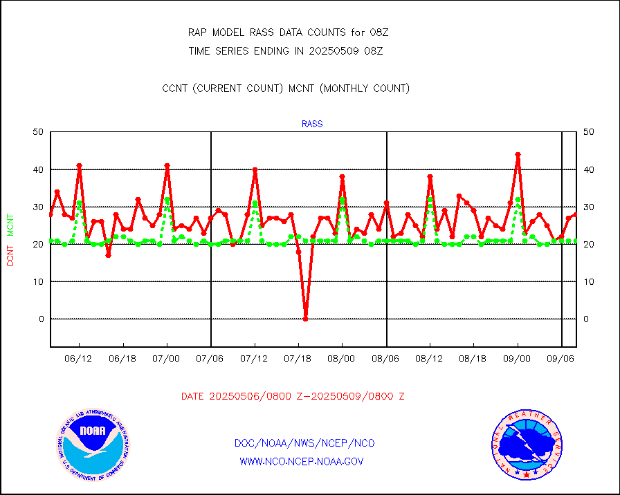
RASS temperatures (NOAA and Multi-Agency) |
18 |
22 |
81.8 % |
2307.50-2308.50 |
||||||||||
Ship - manual and automatic, restricted (BUFR) |
0 |
0 |
n/a |
2307.50-2308.50 |
||||||||||
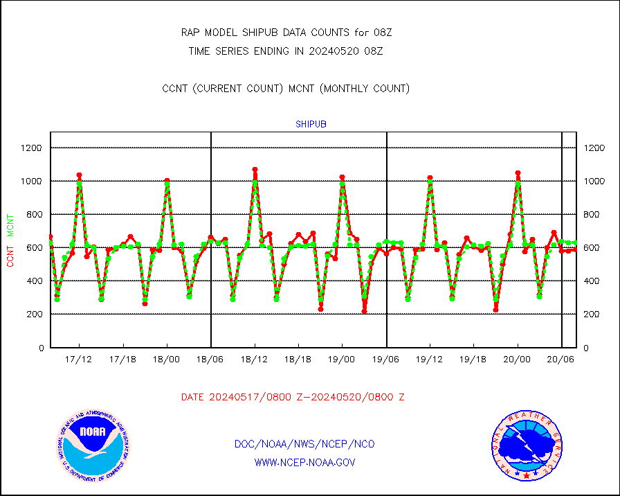
Ship - manual and automatic, unrestricted |
69 |
95 |
72.6 % |
2307.50-2308.50 |
||||||||||
Ship - manual and automatic, unrestricted (BUFR) |
749 |
730 |
102.6 % |
2307.50-2308.50 |
||||||||||
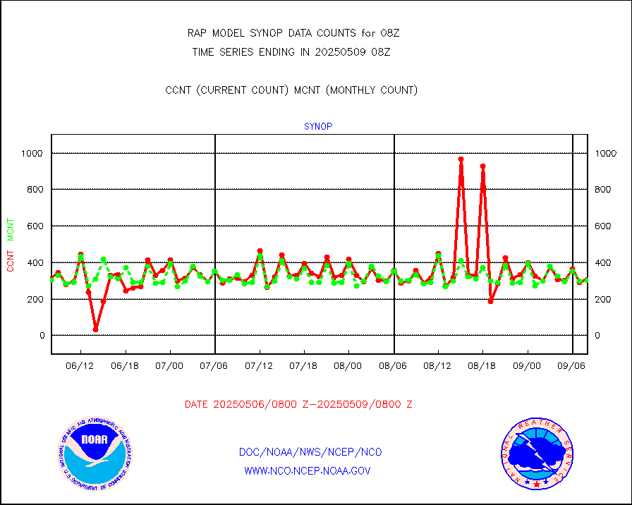
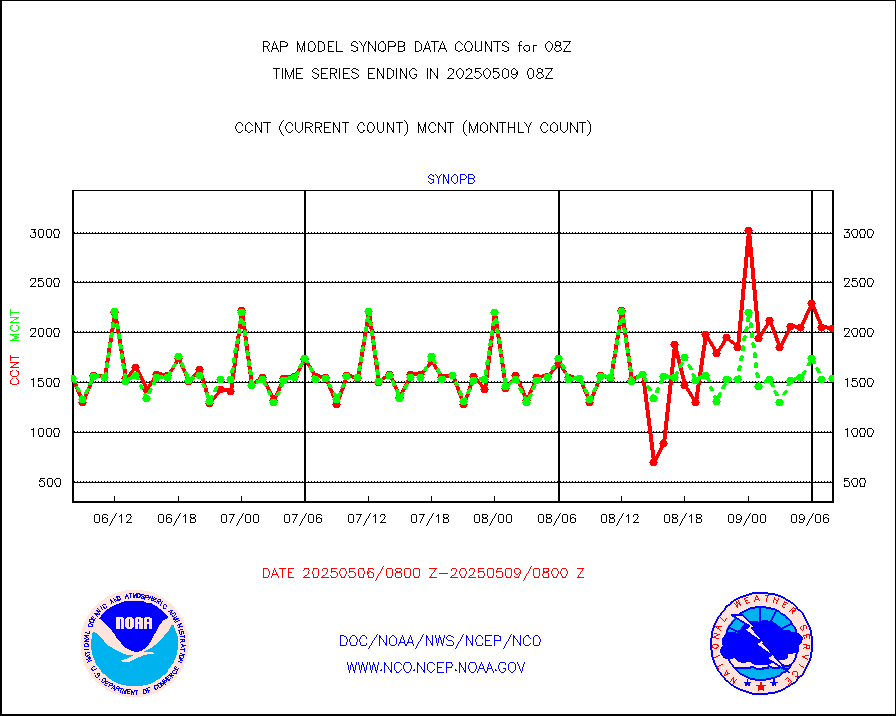
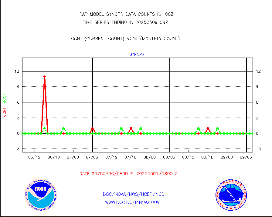
Synoptic - fixed manual and automatic |
282 |
291 |
96.9 % |
2307.50-2308.50 |
||||||||||
Synoptic - fixed manual & auto (decoded fr BUFR) |
1991 |
1787 |
111.4 % |
2307.50-2308.50 |
||||||||||
Tide gauge reports decoded from CREX format |
186 |
184 |
101.1 % |
2307.50-2308.50 |
||||||||||
| Data Types of Opportunity with Normal Counts | ||||||||||||||
|---|---|---|---|---|---|---|---|---|---|---|---|---|---|---|
| Type | Description | Hourly Count | Monthly Average | Percent (%) of Monthly Mean | UTC Time Window | |||||||||
GOES-16&up/NESDIS ir short-wv derived cld motion |
10619 |
13289 |
79.9 % |
2307.00-2307.99 |
||||||||||
MDCRS ACARS acft data (ARINC via AFWA)(AIREP fmt) |
0 |
0 |
n/a |
2304.75-2311.25 |
||||||||||
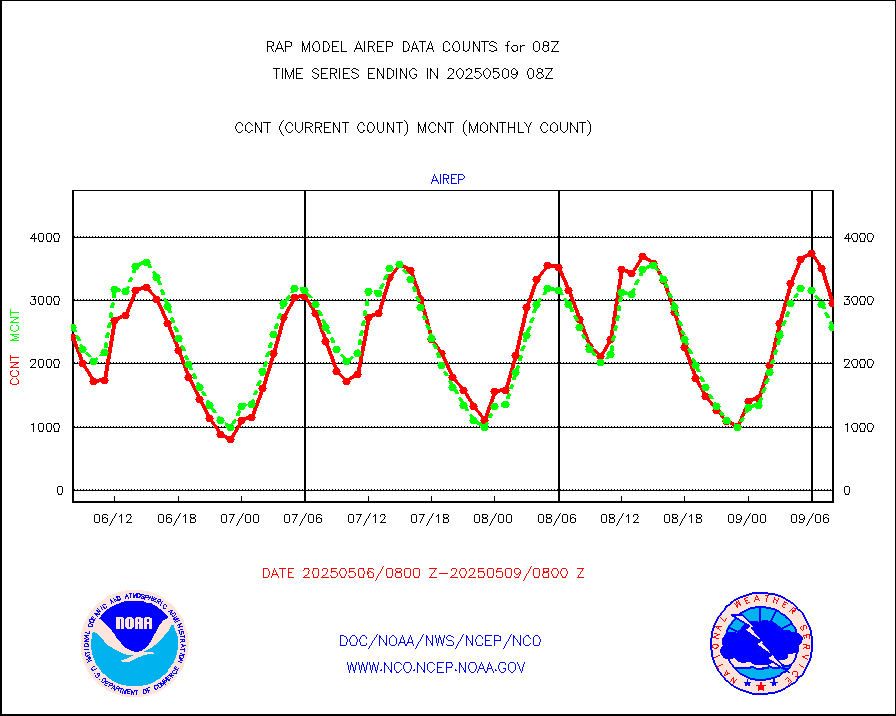
Manual AIREP aircraft data (dcded from AIREP fmt) |
3277 |
2620 |
125.1 % |
2304.75-2311.25 |
||||||||||
AQUA AIRS/AMSU-A/HSB brightness temps- every FOV |
0 |
0 |
n/a |
2305.00-2310.99 |
||||||||||
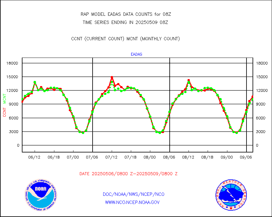
AMDAR aircraft data (decoded from AMDAR format) |
2297 |
4053 |
56.7 % |
2304.75-2311.25 |
||||||||||
AMDAR aircraft data (decoded from BUFR) |
12000 |
12112 |
99.1 % |
2304.75-2311.25 |
||||||||||
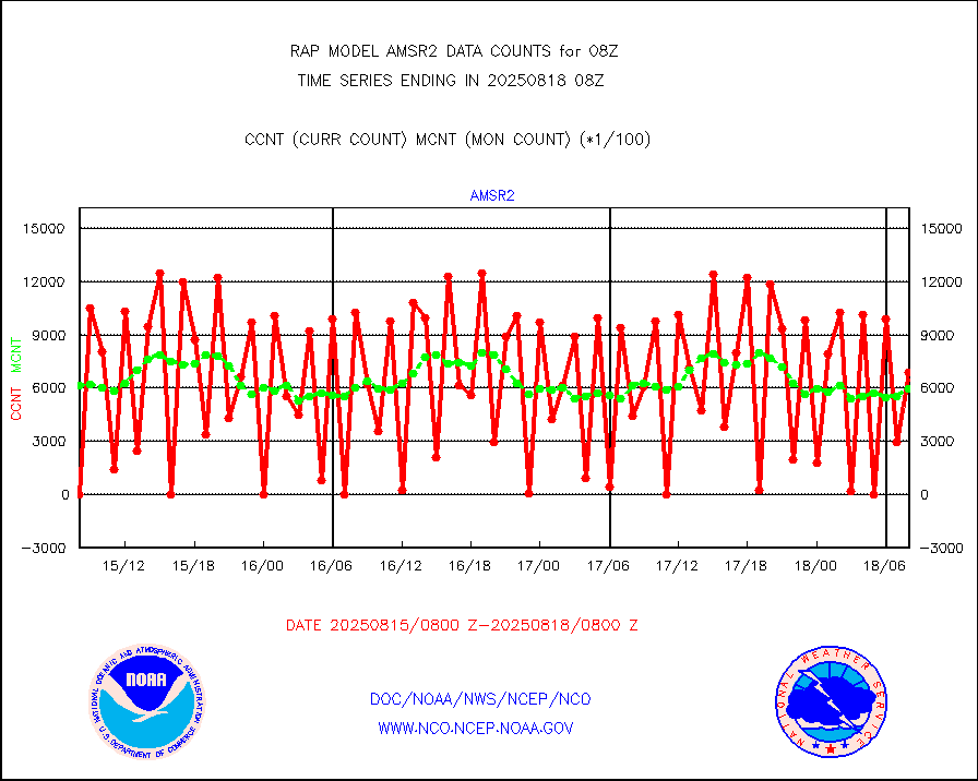
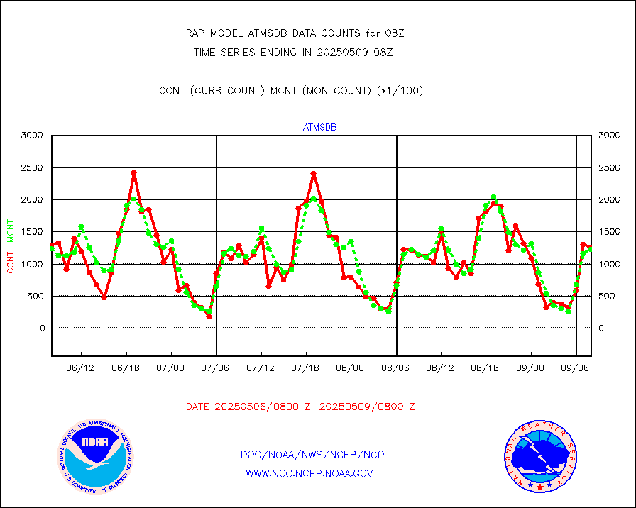
GCOM-W AMSR2 1B brightness temperatures |
454523 |
600384 |
75.7 % |
2305.00-2305.99 |
||||||||||
METOP 1-2 ASCAT products |
22969 |
27323 |
84.1 % |
2306.00-2310.00 |
||||||||||
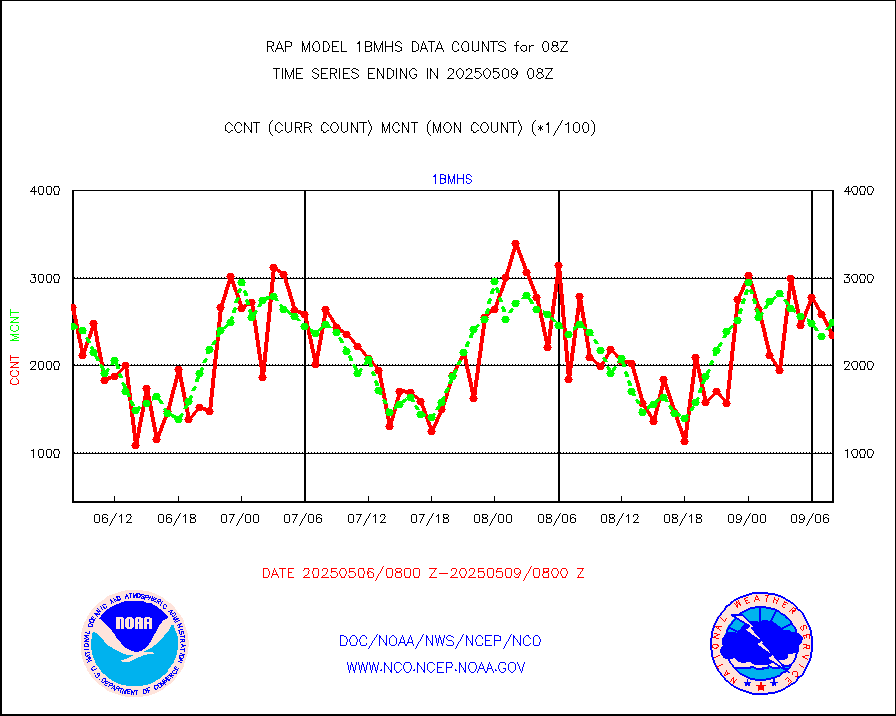
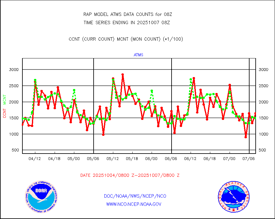
NPP/NOAA-20 ATMS brightness temperatures |
125283 |
152840 |
82.0 % |
2306.00-2309.99 |
||||||||||
NPP/NOAA-20 ATMS bright. temps-direct b-cast SSEC |
109759 |
126312 |
86.9 % |
2306.00-2309.99 |
||||||||||
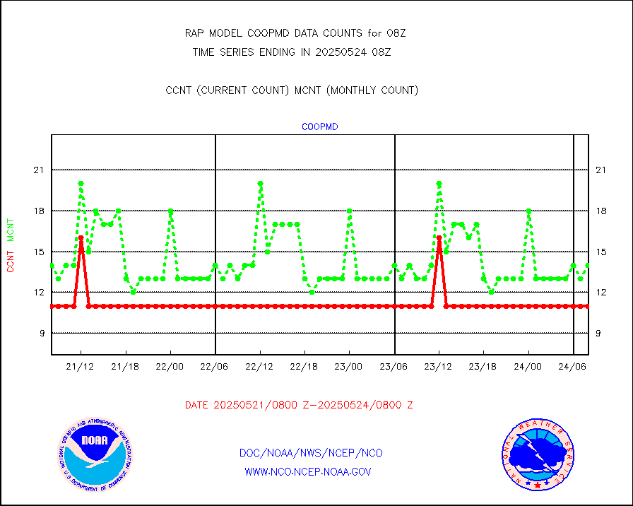
Coop/MADIS NEPP & HCN-Modernization NOAA COOP Obs |
11 |
14 |
78.6 % |
2307.50-2308.50 |
||||||||||
NPP/NOAA-20 CrIS full spctrl radn (431 ch subset) |
77402 |
97362 |
79.5 % |
2306.00-2309.99 |
||||||||||
NPP/NOAA-20 CrIS full spctrl radn dir brdcst SSEC |
99191 |
101999 |
97.2 % |
2306.00-2309.99 |
||||||||||
Coast Guard |
6 |
6 |
100.0 % |
2307.50-2308.50 |
||||||||||
Drifting buoys (decoded from BUFR) |
530 |
544 |
97.4 % |
2307.50-2308.50 |
||||||||||
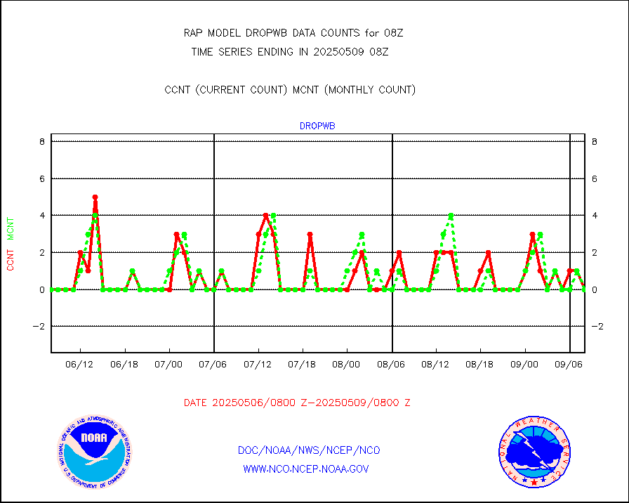
Dropwinsonde (from TEMP DROP) |
0 |
0 |
n/a |
2307.00-2309.00 |
||||||||||
Dropwinsonde (decoded from BUFR) |
0 |
0 |
n/a |
2307.00-2309.00 |
||||||||||
E-AMDAR (European AMDAR acft decoded from BUFR) |
10986 |
10472 |
104.9 % |
2304.75-2311.25 |
||||||||||
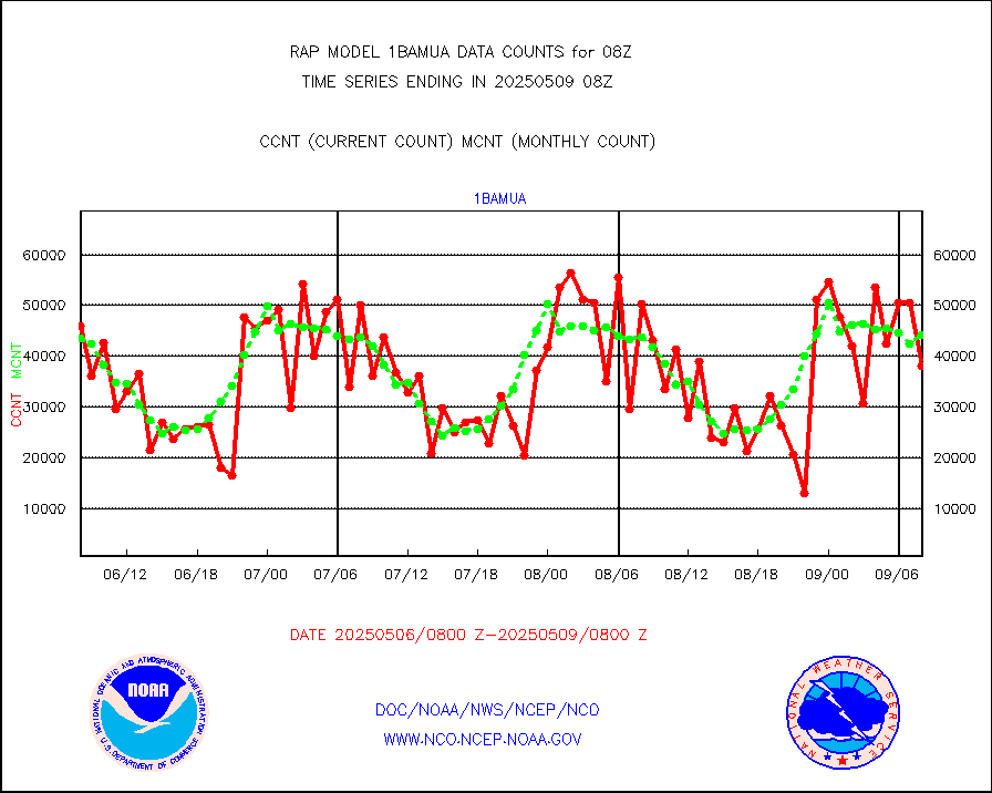
NOAA 15-19 & METOP 1-2 AMSU-A proc btmps frm RARS |
15352 |
11645 |
131.8 % |
2307.00-2309.00 |
||||||||||
NPP Adv. Tech. MW Sndr (ATMS) br. temps from RARS |
85366 |
109949 |
77.6 % |
2306.00-2309.99 |
||||||||||
NOAA 15-19 & METOP 1-2 HIRS-3/4 pr btmps frm RARS |
23987 |
18935 |
126.7 % |
2307.00-2309.00 |
||||||||||
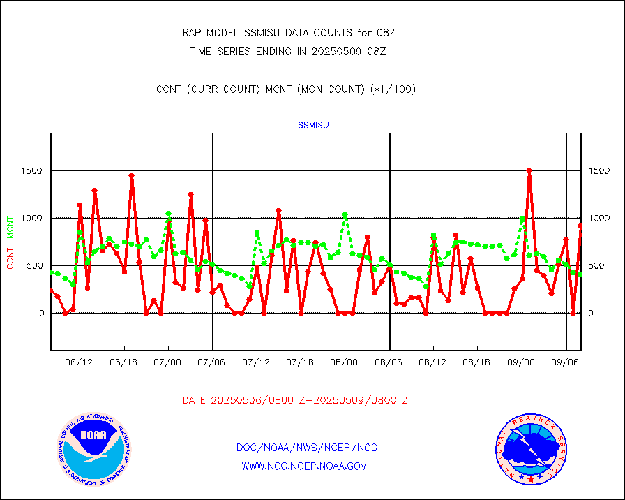
METOP 1-2 IASI 1C radiance data vbl chn from RARS |
9493 |
11642 |
81.5 % |
2306.00-2309.99 |
||||||||||
NOAA 18-19 & METOP 1-2 MHS proc. btemps from RARS |
121211 |
89071 |
136.1 % |
2307.00-2309.00 |
||||||||||
GPM GMI Level 1C-R brightness temperatures |
491897 |
336219 |
146.3 % |
2305.00-2310.99 |
||||||||||
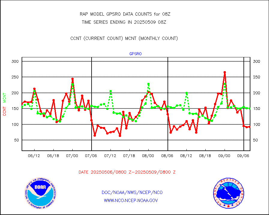
GPS radio occultation data |
158 |
152 |
103.9 % |
2306.00-2309.99 |
||||||||||
GOES-16/17 All Sky Radiances (proc.) |
812097 |
812097 |
100.0 % |
2306.00-2309.99 |
||||||||||
GOES-16/17 Clear Sky Radiances (proc.) |
383732 |
363506 |
105.6 % |
2306.00-2309.99 |
||||||||||
MTSAT/JMA water vapor imager derived cloud motion |
2977 |
2899 |
102.7 % |
2305.50-2310.50 |
||||||||||
GOES-16&up/NESDIS wv imgr/deep-lyr derivd cld mtn |
8056 |
7063 |
114.1 % |
2307.00-2307.99 |
||||||||||
METEOSAT/EUMETSAT wvpr imgr drv cld motion NBseq |
4941 |
5033 |
98.2 % |
2306.50-2309.49 |
||||||||||
GOES-16&up/NESDIS wv imgr/cld-top derived cld mtn |
12688 |
13501 |
94.0 % |
2307.00-2307.99 |
||||||||||
METOP 1-2 IASI 1C radiances-direct broadcast SSEC |
68624 |
56933 |
120.5 % |
2306.00-2309.99 |
||||||||||
METEOSAT/EUMETSAT ir lg-wave drv cld motion NBseq |
3096 |
3103 |
99.8 % |
2306.50-2309.49 |
||||||||||
VIIRS (NPP/NOAA-20) ir lg-wv drv cloud motion(NB) |
0 |
0 |
n/a |
2305.50-2310.50 |
||||||||||
AVHRR (NOAA/METOP) ir lg-wave derived cld motion |
0 |
0 |
n/a |
2305.50-2310.50 |
||||||||||
AVHRR (METOP) ir lg-wave derived cld motion |
0 |
0 |
n/a |
2306.50-2309.49 |
||||||||||
MTSAT/JMA infrared long-wave derived cloud motion |
2300 |
2269 |
101.4 % |
2305.50-2310.50 |
||||||||||
GOES-16&up/NESDIS ir long-wave derived cld motion |
27252 |
30374 |
89.7 % |
2307.00-2307.99 |
||||||||||
Korean AMDAR aircraft data (decoded from BUFR) |
249 |
246 |
101.2 % |
2304.75-2311.25 |
||||||||||
Land-based CMAN stations decoded from CMAN format |
36 |
45 |
80.0 % |
2307.50-2308.50 |
||||||||||
LLDN Long-rng lightning from Vaisala via NOAAPORT |
220233 |
88192 |
249.7 % |
2307.00-2308.50 |
||||||||||
NLDN Shrt-rng lightning from Vaisala via NOAAPORT |
4830 |
4344 |
111.2 % |
2307.00-2308.50 |
||||||||||
Moored buoys (decoded from BUFR) |
575 |
519 |
110.8 % |
2307.50-2308.50 |
||||||||||
Mesonet/MADIS Colorado E-470 (Interstate 470) |
24 |
12 |
200.0 % |
2307.50-2308.50 |
||||||||||
Mesonet/MADIS Alaska Department of Transportation |
112 |
88 |
127.3 % |
2307.50-2308.50 |
||||||||||
Mesonet/MADIS U.S. Army Aberdeen Proving Grounds |
0 |
0 |
n/a |
2307.50-2308.50 |
||||||||||
Mesonet/MADIS Citizen Weather Observers Program |
55982 |
59932 |
93.4 % |
2307.50-2308.50 |
||||||||||
Mesonet/MADIS AWS Convergence Technologies, Inc. |
23049 |
23437 |
98.3 % |
2307.50-2308.50 |
||||||||||
Mesonet/MADIS "Anything Weather" |
0 |
0 |
n/a |
2307.50-2308.50 |
||||||||||
Mesonet/MADIS Colorado Dept. of Transportation |
0 |
0 |
n/a |
2307.50-2308.50 |
||||||||||
Mesonet/MADIS DC Net |
0 |
0 |
n/a |
2307.50-2308.50 |
||||||||||
Mesonet/MADIS Denver Urban Drainage & Flood Cntrl |
0 |
0 |
n/a |
2307.50-2308.50 |
||||||||||
Mesonet/MADIS Florida (FAWN & USF) |
3 |
4 |
75.0 % |
2307.50-2308.50 |
||||||||||
Mesonet/MADIS Florida Dept. of Transportation |
0 |
0 |
n/a |
2307.50-2308.50 |
||||||||||
Mesonet/MADIS Georgia Dept. of Transportation |
0 |
0 |
n/a |
2307.50-2308.50 |
||||||||||
Mesonet/MADIS NWS Hydromet Auto Data System(HADS) |
4275 |
5404 |
79.1 % |
2307.50-2308.50 |
||||||||||
Mesonet/MADIS Iowa Environmental |
159 |
173 |
91.9 % |
2307.50-2308.50 |
||||||||||
Mesonet/MADIS Indiana Dept. of Transportation |
0 |
0 |
n/a |
2307.50-2308.50 |
||||||||||
Mesonet/MADIS Iowa Department of Transportation |
0 |
0 |
n/a |
2307.50-2308.50 |
||||||||||
Mesonet/MADIS Kansas Department of Transportation |
250 |
320 |
78.1 % |
2307.50-2308.50 |
||||||||||
Mesonet/MADIS Oklahoma Mesonet |
525 |
585 |
89.7 % |
2307.50-2308.50 |
||||||||||
Mesonet/MADIS Louisiana State/Jackson State Univ. |
0 |
0 |
n/a |
2307.50-2308.50 |
||||||||||
Mesonet/MADIS Missouri Commercial Agricult Wx Net |
278 |
299 |
93.0 % |
2307.50-2308.50 |
||||||||||
Mesonet/MADIS Minnesota Dept. of Transportation |
0 |
0 |
n/a |
2307.50-2308.50 |
||||||||||
Mesonet/MADIS NOS-Phys Oceanographic Realtime Sys |
223 |
257 |
86.8 % |
2307.50-2308.50 |
||||||||||
Mesonet/MADIS NFIC Remote Automated Wx Stns(RAWS) |
1276 |
1602 |
79.7 % |
2307.50-2308.50 |
||||||||||
Mesonet/MADIS many providers, not separated out |
39186 |
41317 |
94.8 % |
2307.50-2308.50 |
||||||||||
Mesonet/MADIS UrbaNet |
3040 |
3423 |
88.8 % |
2307.50-2308.50 |
||||||||||
Mesonet/MADIS Virginia Dept. of Transportation |
0 |
0 |
n/a |
2307.50-2308.50 |
||||||||||
Mesonet/MADIS "Weather for You" |
0 |
0 |
n/a |
2307.50-2308.50 |
||||||||||
Mesonet/MADIS Wisconsin Dept. of Transportation |
0 |
0 |
n/a |
2307.50-2308.50 |
||||||||||
Mesonet/MADIS MesoWest (many subproviders) |
25414 |
37971 |
66.9 % |
2307.50-2308.50 |
||||||||||
Mesonet/MADIS West Texas |
5033 |
5304 |
94.9 % |
2307.50-2308.50 |
||||||||||
METOP 1-2 IASI 1C radiance data (varbl. channels) |
48435 |
42674 |
113.5 % |
2306.00-2309.99 |
||||||||||
NEXRAD Vel Azm Dsp(VAD) winds via Level 2 decoder |
700 |
764 |
91.6 % |
2307.00-2309.00 |
||||||||||
NOAA 16-19 Solar Backscatter UV-2 rad frm V8 BUFR |
0 |
0 |
n/a |
2306.00-2308.99 |
||||||||||
PIBAL (from PILOT, PILOT SHIP, PILOT MOBIL) |
0 |
0 |
n/a |
2307.00-2309.00 |
||||||||||
PIBAL (decoded from BUFR) |
0 |
0 |
n/a |
2307.00-2309.00 |
||||||||||
Manual PIREP aircraft data (dcded from AIREP fmt) |
41 |
63 |
65.1 % |
2304.75-2311.25 |
||||||||||
Profilr winds from PIBAL (PILOT,PILOT SHIP/MOBIL) |
0 |
0 |
n/a |
2306.50-2309.50 |
||||||||||
Rawinsonde - fixed land (decoded from BUFR) |
0 |
0 |
n/a |
2307.00-2309.00 |
||||||||||
Rawinsonde - mobile land (from TEMP/PILOT MOBIL) |
0 |
0 |
n/a |
2307.00-2309.00 |
||||||||||
Rawinsonde - mobile land (decoded from BUFR) |
0 |
0 |
n/a |
2307.00-2309.00 |
||||||||||
Rawinsonde - ship (from TEMP SHIP, PILOT SHIP) |
0 |
0 |
n/a |
2307.00-2309.00 |
||||||||||
Rawinsonde - ship (decoded from BUFR) |
0 |
0 |
n/a |
2307.00-2309.00 |
||||||||||
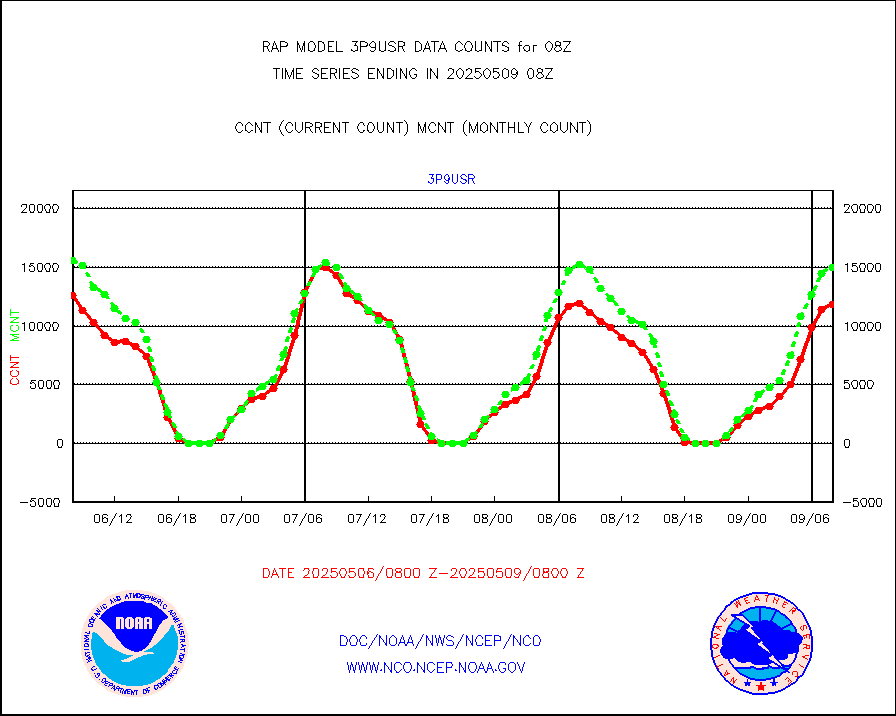
NEXRAD radial wind (Level 2 - GTS) |
798209 |
933336 |
85.5 % |
2307.50-2308.49 |
||||||||||
Flight level reconnaissance aircraft data |
0 |
0 |
n/a |
2307.00-2309.00 |
||||||||||
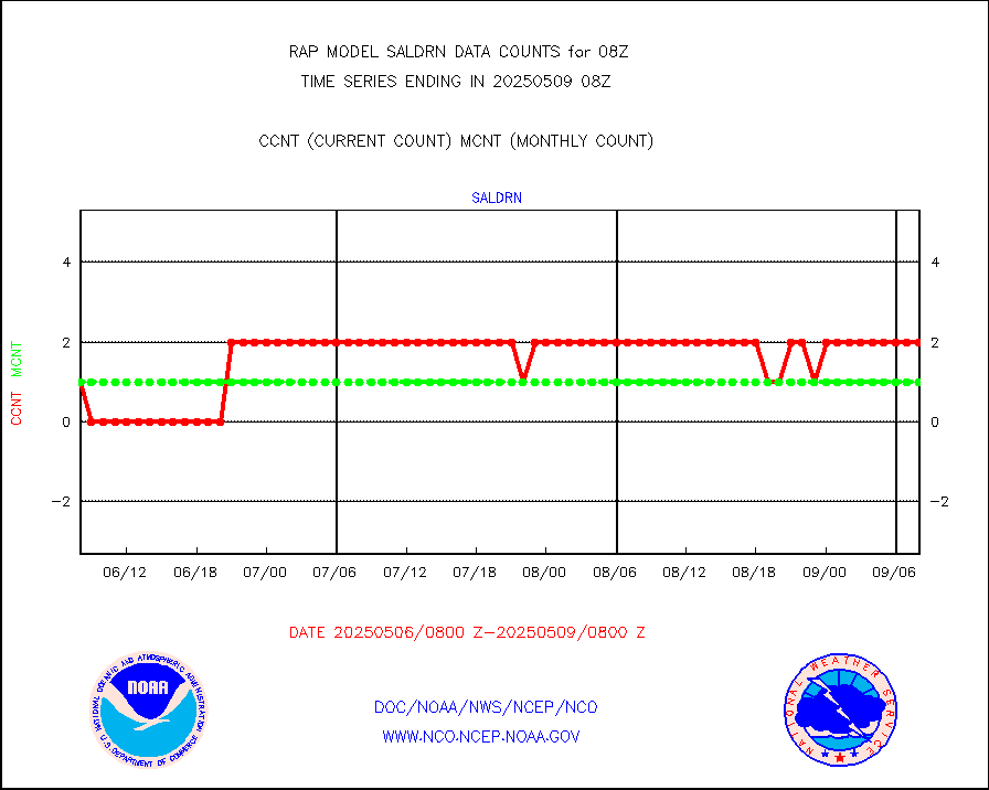
Surface Marine Saildrone (decoded from BUFR) |
2 |
1 |
200.0 % |
2306.00-2309.99 |
||||||||||
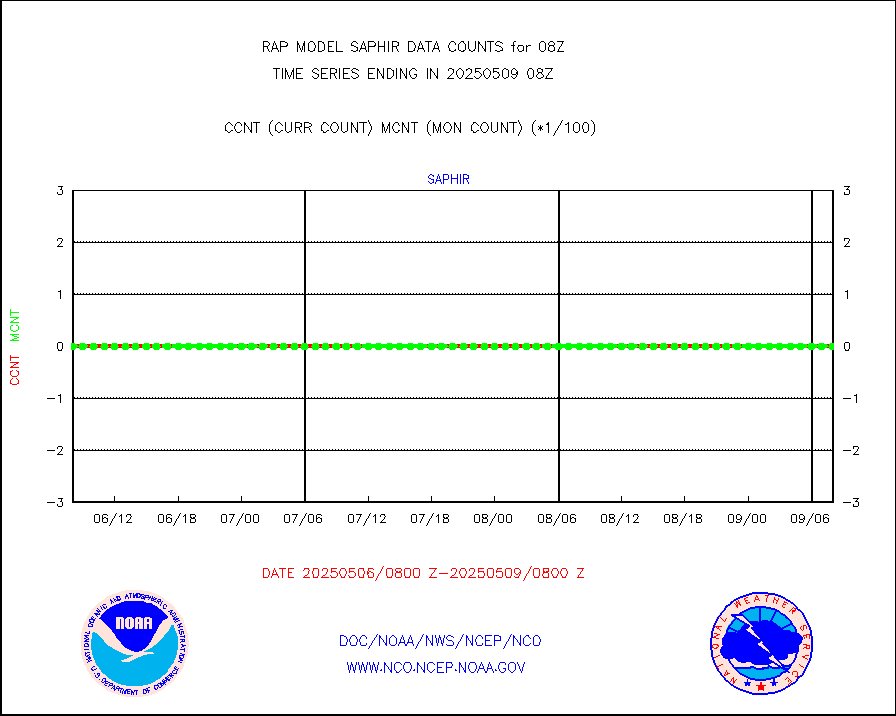
Megha-Tropiques SAPHIR L1A2 brightness temps |
0 |
0 |
n/a |
2305.00-2310.99 |
||||||||||
METEOSAT-10 2nd Gen SEVIRI All Sky Radiance(proc) |
9512 |
9512 |
100.0 % |
2306.00-2309.99 |
||||||||||
METEOSAT-10 2nd Gen SEVIRI Clr Sky Radiance(proc) |
0 |
0 |
n/a |
2306.00-2309.99 |
||||||||||
Ship - manual and automatic, restricted |
21 |
7 |
300.0 % |
2307.50-2308.50 |
||||||||||
NOW COVER, DEPTH/DENSITY AND WATER EQUIVALENT |
3857 |
7409 |
52.1 % |
2306.00-2310.00 |
||||||||||
DMSP SSM/IS 1C radiance data (Unified Pre-Proc.) |
44790 |
31484 |
142.3 % |
2306.00-2309.99 |
||||||||||
Sub-surface float and glider profile (BUFR) |
0 |
3 |
0.0 % |
2306.00-2309.99 |
||||||||||
Synoptic - restricted (WMO Res 40) manual & auto. |
0 |
0 |
n/a |
2307.50-2308.50 |
||||||||||
Synoptic - restricted (WMO Res 40)(decoded BUFR) |
349 |
347 |
100.6 % |
2307.50-2308.50 |
||||||||||
Synoptic - mobile manual & auto (decoded fr BUFR) |
0 |
0 |
n/a |
2307.50-2308.50 |
||||||||||
TAMDAR aircft data-all types(from Panasonic,BUFR) |
123 |
112 |
109.8 % |
2304.75-2311.25 |
||||||||||
MTSAT/JMA visible derived cloud motion |
950 |
1076 |
88.3 % |
2305.50-2310.50 |
||||||||||
GOES-16&up/NESDIS visible derived cloud motion |
0 |
0 |
n/a |
2307.00-2307.99 |
||||||||||
METEOSAT/EUMETSAT visible drv cld motion NBseq |
4445 |
3039 |
146.3 % |
2306.50-2309.49 |
||||||||||


