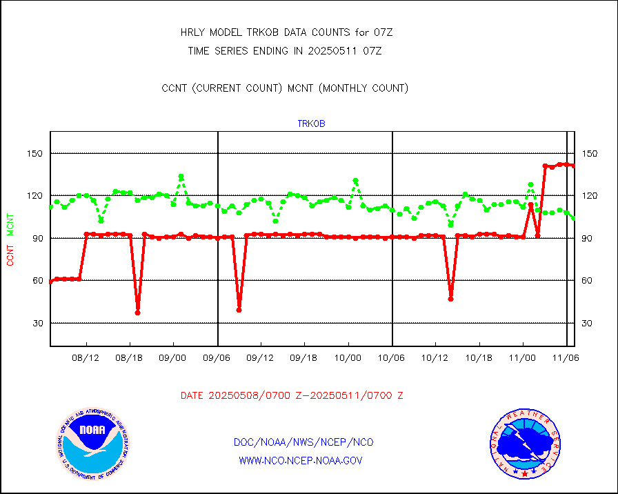
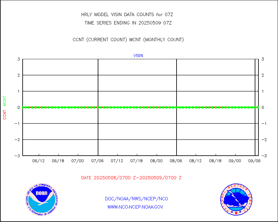
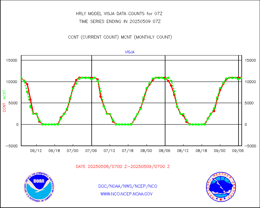
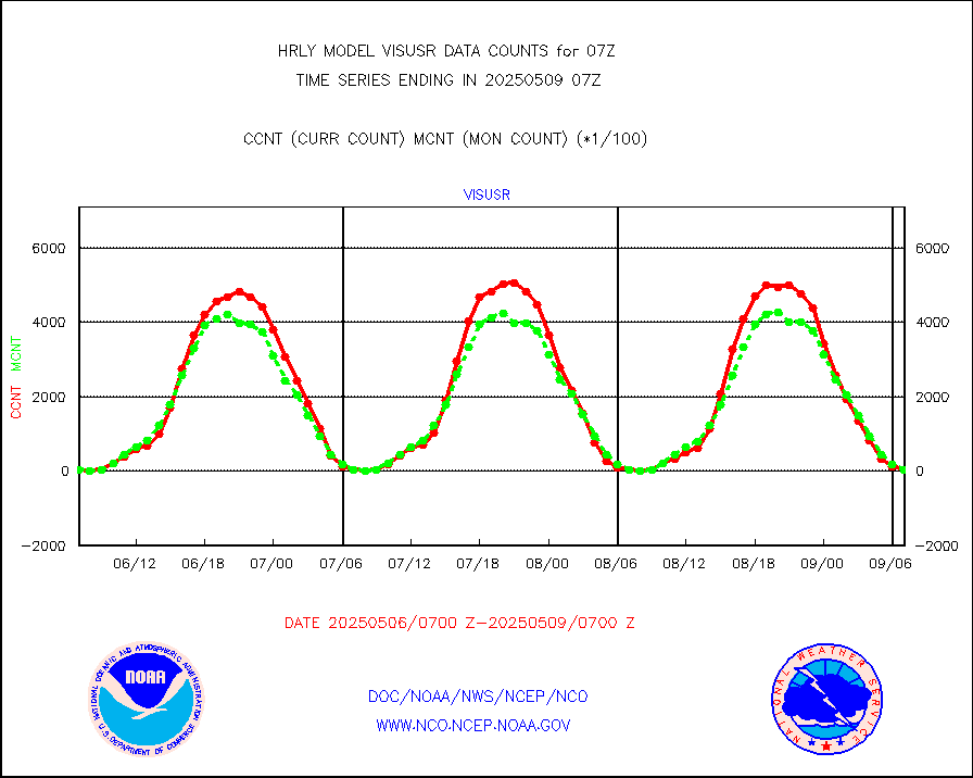
| Suspect Data Shortages in Critical Types - Monitor | ||||||||||||||
|---|---|---|---|---|---|---|---|---|---|---|---|---|---|---|
| Type | Description | Hourly Count | Monthly Average | Percent (%) of Monthly Mean | UTC Time Window | |||||||||
NOAA 18-19 & METOP 1-2 HIRS-4 NCEP-proc. br.temps |
0 |
12761 |
0.0 % |
0105.00-0105.99 |
||||||||||
NOAA 15-19 & METOP 1-2 HIRS-3/4 pr btmps frm RARS |
0 |
6946 |
0.0 % |
0106.50-0107.49 |
||||||||||
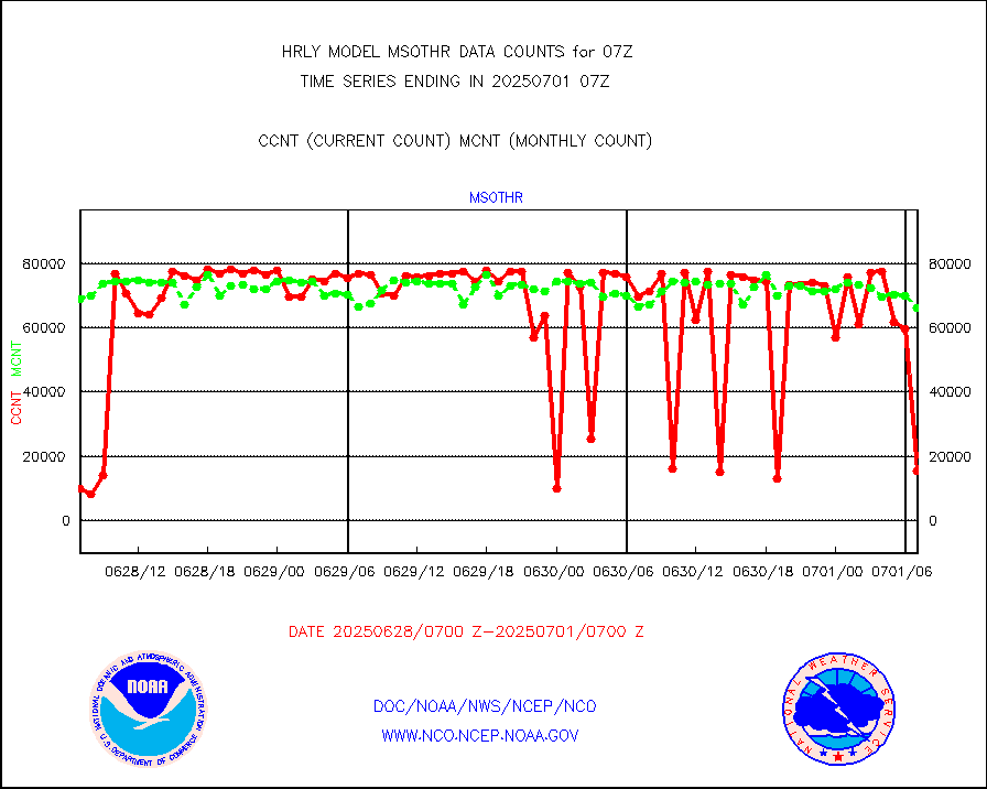
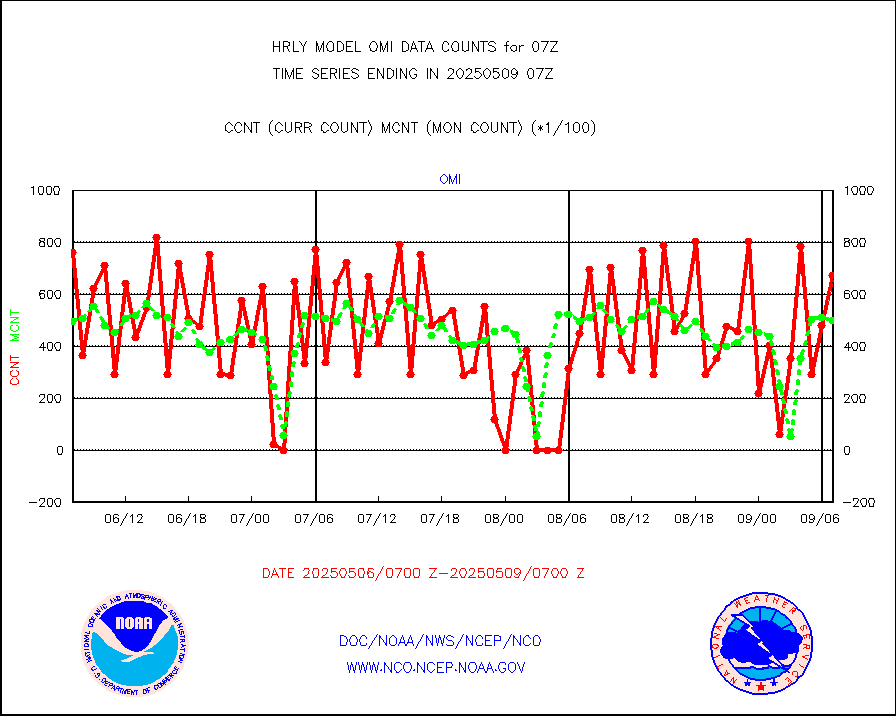
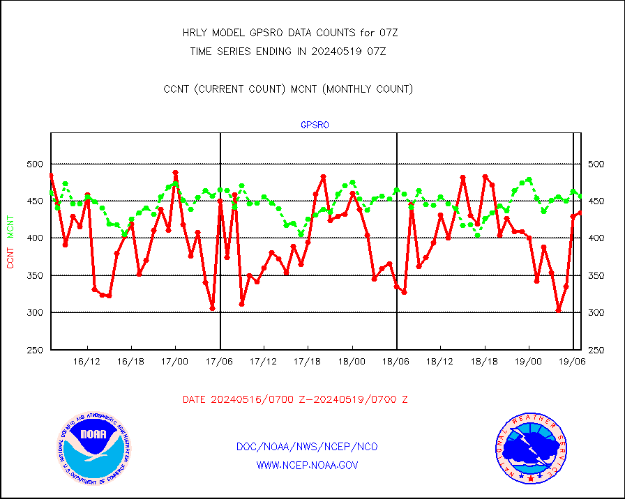
Grnd-based Gbl Navigation Sat System (GNSS) data |
1435 |
6820 |
21.0 % |
0106.00-0106.99 |
||||||||||
| Shortage in Data Type of Opportunity - Monitor | ||||||||||||||
|---|---|---|---|---|---|---|---|---|---|---|---|---|---|---|
| Type | Description | Hourly Count | Monthly Average | Percent (%) of Monthly Mean | UTC Time Window | |||||||||
P.M.(N18-19) AVHRR GAC NCEP-proc clr & sea btemps |
0 |
387510 |
0.0 % |
0104.50-0105.49 |
||||||||||
METOP 1-2 IASI 1C radiance data vbl chn from RARS |
0 |
1598 |
0.0 % |
0106.00-0106.99 |
||||||||||
INDIA SATWIND, INSAT WV channel |
0 |
394 |
0.0 % |
0106.00-0106.99 |
||||||||||
INDIA SATWIND, INSAT IR channel |
0 |
519 |
0.0 % |
0106.00-0106.99 |
||||||||||
INDIA SATWIND, INSAT VIS channel |
0 |
48 |
0.0 % |
0106.00-0106.99 |
||||||||||
| Critical Data with Normal Counts | ||||||||||||||
|---|---|---|---|---|---|---|---|---|---|---|---|---|---|---|
| Type | Description | Hourly Count | Monthly Average | Percent (%) of Monthly Mean | UTC Time Window | |||||||||
NOAA 15-19 & METOP 1-2 AMSU-A NCEP-proc. br.temps |
26735 |
34626 |
77.2 % |
0105.00-0105.99 |
||||||||||
NOAA 18-19 & METOP 1-2 MHS NCEP-proces. br. temps |
238233 |
257206 |
92.6 % |
0105.00-0105.99 |
||||||||||
MDCRS ACARS acft data from ARINC(dcded from BUFR) |
8833 |
10947 |
80.7 % |
0106.50-0107.49 |
||||||||||
Manual AIREP aircraft data (dcded from AIREP fmt) |
701 |
797 |
88.0 % |
0106.50-0107.49 |
||||||||||
AQUA AIRS/AMSU-A/HSB brightness temps- every FOV |
0 |
0 |
n/a |
0104.50-0105.49 |
||||||||||
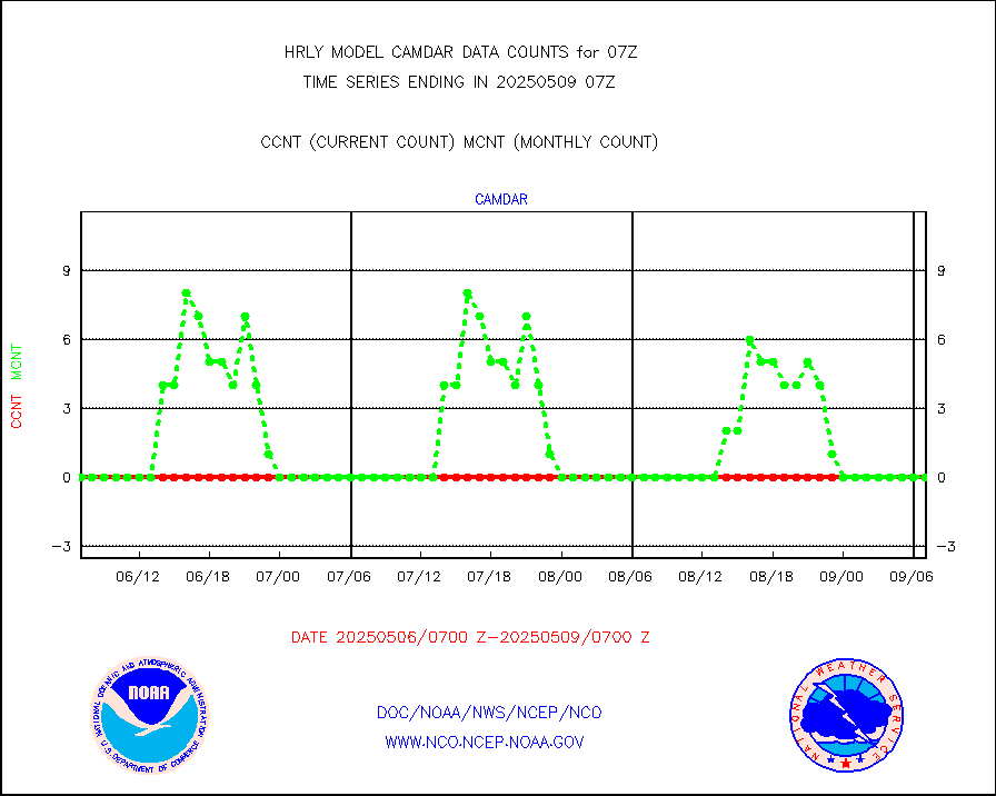
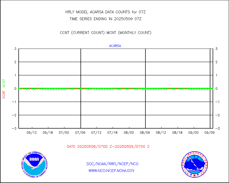
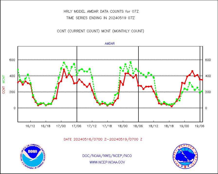
AMDAR aircraft data (decoded from AMDAR format) |
333 |
224 |
148.7 % |
0106.50-0107.49 |
||||||||||
AMDAR aircraft data (decoded from BUFR) |
2533 |
2650 |
95.6 % |
0106.50-0107.49 |
||||||||||
METOP 1-2 ASCAT products |
63000 |
56776 |
111.0 % |
0105.50-0106.49 |
||||||||||
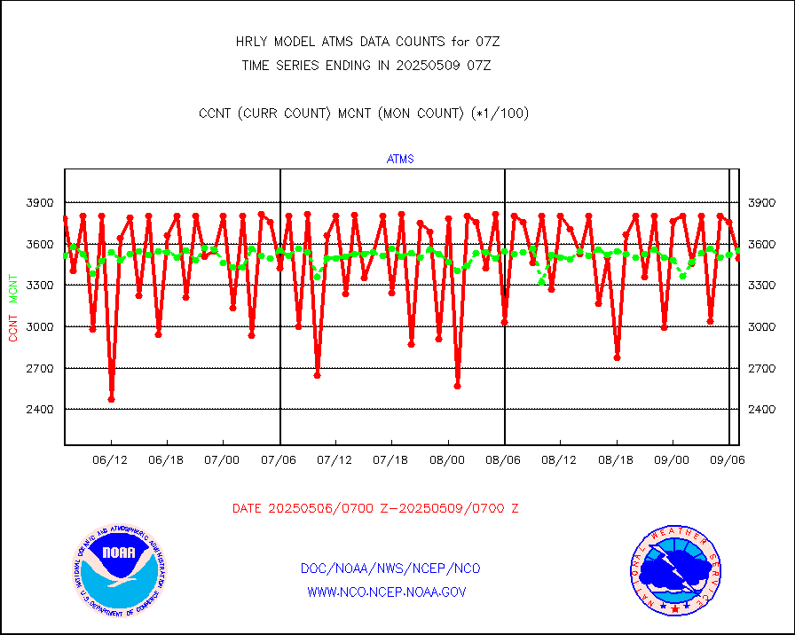
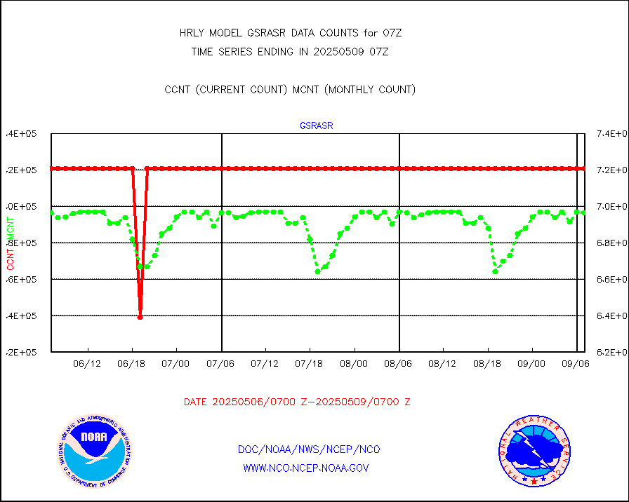
NPP/NOAA-20 ATMS brightness temperatures |
359616 |
345565 |
104.1 % |
0105.50-0106.49 |
||||||||||
Canadian AMDAR aircraft data (decoded from BUFR) |
0 |
0 |
n/a |
0106.50-0107.49 |
||||||||||
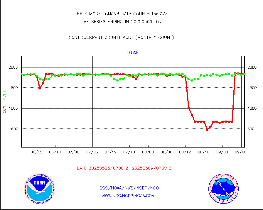
Surface Marine CMAN rpts decoded from BUFR format |
1860 |
1861 |
99.9 % |
0106.50-0107.50 |
||||||||||
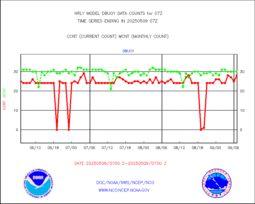
Buoys decoded from FM-18 fmt (moored or drifting) |
7 |
19 |
36.8 % |
0106.50-0107.49 |
||||||||||
E-AMDAR (European AMDAR acft decoded from BUFR) |
1813 |
2103 |
86.2 % |
0106.50-0107.49 |
||||||||||
NOAA 15-19 & METOP 1-2 AMSU-A proc btmps frm RARS |
2820 |
8218 |
34.3 % |
0106.50-0107.49 |
||||||||||
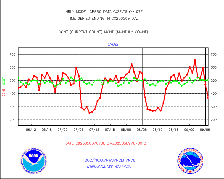
GPS radio occultation data |
521 |
520 |
100.2 % |
0104.50-0105.49 |
||||||||||
GOES-16/17 All Sky Radiances (proc.) |
720952 |
720952 |
100.0 % |
0106.50-0107.49 |
||||||||||
GOES-16/17 Clear Sky Radiances (proc.) |
344853 |
348910 |
98.8 % |
0106.50-0107.49 |
||||||||||
MTSAT/JMA water vapor imager derived cloud motion |
21659 |
20047 |
108.0 % |
0104.50-0105.49 |
||||||||||
MODIS (AQUA/TERRA) wvpr imager derived cld motion |
0 |
0 |
n/a |
0103.00-0103.99 |
||||||||||
GOES-16&up/NESDIS wv imgr/cld-top derived cld mtn |
24804 |
26414 |
93.9 % |
0106.00-0106.99 |
||||||||||
METEOSAT/EUMETSAT ir lg-wave drv cld motion NBseq |
21141 |
20981 |
100.8 % |
0105.50-0106.49 |
||||||||||
MTSAT/JMA infrared long-wave derived cloud motion |
16800 |
16568 |
101.4 % |
0104.50-0105.49 |
||||||||||
MODIS (AQUA/TERRA) ir l-wave derived cloud motion |
0 |
0 |
n/a |
0103.00-0103.99 |
||||||||||
GOES-16&up/NESDIS ir long-wave derived cld motion |
82892 |
83323 |
99.5 % |
0106.00-0106.99 |
||||||||||
GOES/NASA(Langley) hi-res. (1x1 f-o-v) cloud data |
6407837 |
6343735 |
101.0 % |
0106.50-0107.49 |
||||||||||
Buoys decoded from FM-13 format (moored) |
123 |
121 |
101.7 % |
0106.50-0107.49 |
||||||||||
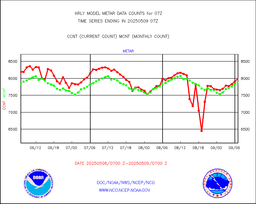
Aviation - METAR |
7868 |
7861 |
100.1 % |
0106.50-0107.49 |
||||||||||
Mesonet/MADIS Colorado E-470 (Interstate 470) |
24 |
24 |
100.0 % |
0106.50-0107.49 |
||||||||||
Mesonet/MADIS Alaska Department of Transportation |
118 |
85 |
138.8 % |
0106.50-0107.49 |
||||||||||
Mesonet/MADIS U.S. Army Aberdeen Proving Grounds |
0 |
0 |
n/a |
0106.50-0107.49 |
||||||||||
Mesonet/MADIS Citizen Weather Observers Program |
15050 |
56751 |
26.5 % |
0106.50-0107.49 |
||||||||||
Mesonet/MADIS AWS Convergence Technologies, Inc. |
5620 |
19496 |
28.8 % |
0106.50-0107.49 |
||||||||||
Mesonet/MADIS "Anything Weather" |
0 |
0 |
n/a |
0106.50-0107.49 |
||||||||||
Mesonet/MADIS Colorado Dept. of Transportation |
0 |
0 |
n/a |
0106.50-0107.49 |
||||||||||
Mesonet/MADIS DC Net |
0 |
0 |
n/a |
0106.50-0107.49 |
||||||||||
Mesonet/MADIS Denver Urban Drainage & Flood Cntrl |
0 |
0 |
n/a |
0106.50-0107.49 |
||||||||||
Mesonet/MADIS Florida (FAWN & USF) |
4 |
4 |
100.0 % |
0106.50-0107.49 |
||||||||||
Mesonet/MADIS Florida Dept. of Transportation |
0 |
0 |
n/a |
0106.50-0107.49 |
||||||||||
Mesonet/MADIS Georgia Dept. of Transportation |
0 |
0 |
n/a |
0106.50-0107.49 |
||||||||||
Mesonet/MADIS NWS Hydromet Auto Data System(HADS) |
5895 |
6220 |
94.8 % |
0106.50-0107.49 |
||||||||||
Mesonet/MADIS Iowa Environmental |
195 |
186 |
104.8 % |
0106.50-0107.49 |
||||||||||
Mesonet/MADIS Indiana Dept. of Transportation |
0 |
0 |
n/a |
0106.50-0107.49 |
||||||||||
Mesonet/MADIS Iowa Department of Transportation |
0 |
0 |
n/a |
0106.50-0107.49 |
||||||||||
Mesonet/MADIS Kansas Department of Transportation |
397 |
354 |
112.1 % |
0106.50-0107.49 |
||||||||||
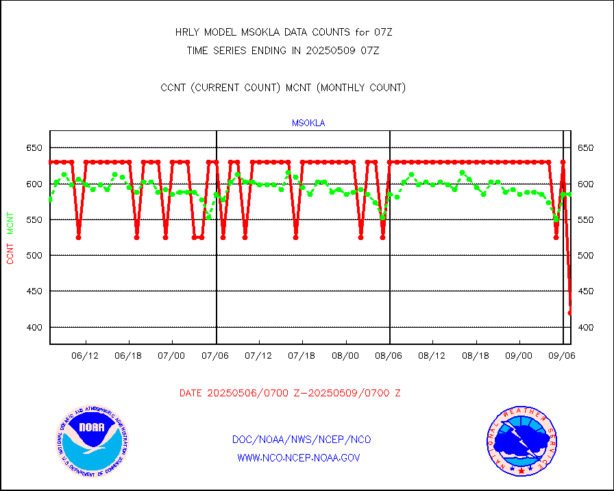
Mesonet/MADIS Oklahoma Mesonet |
630 |
630 |
100.0 % |
0106.50-0107.49 |
||||||||||
Mesonet/MADIS Louisiana State/Jackson State Univ. |
0 |
0 |
n/a |
0106.50-0107.49 |
||||||||||
Mesonet/MADIS Missouri Commercial Agricult Wx Net |
333 |
337 |
98.8 % |
0106.50-0107.49 |
||||||||||
Mesonet/MADIS Minnesota Dept. of Transportation |
0 |
0 |
n/a |
0106.50-0107.49 |
||||||||||
Mesonet/MADIS NOS-Phys Oceanographic Realtime Sys |
339 |
378 |
89.7 % |
0106.50-0107.49 |
||||||||||
Mesonet/MADIS NFIC Remote Automated Wx Stns(RAWS) |
1971 |
1780 |
110.7 % |
0106.50-0107.49 |
||||||||||
Mesonet/MADIS many providers, not separated out |
15194 |
66359 |
22.9 % |
0106.00-0107.49 |
||||||||||
Mesonet/MADIS Virginia Dept. of Transportation |
0 |
0 |
n/a |
0106.50-0107.49 |
||||||||||
Mesonet/MADIS "Weather for You" |
0 |
0 |
n/a |
0106.50-0107.49 |
||||||||||
Mesonet/MADIS Wisconsin Dept. of Transportation |
0 |
0 |
n/a |
0106.50-0107.49 |
||||||||||
Mesonet/MADIS MesoWest (many subproviders) |
7462 |
32984 |
22.6 % |
0106.50-0107.49 |
||||||||||
Mesonet/MADIS West Texas |
6268 |
6105 |
102.7 % |
0106.50-0107.49 |
||||||||||
METOP 1-2 IASI 1C radiance data (varbl. channels) |
104280 |
84739 |
123.1 % |
0105.00-0105.99 |
||||||||||
NEXRAD Vel Azm Dsp(VAD) winds via radar coded msg |
0 |
0 |
n/a |
0106.50-0107.49 |
||||||||||
Aura Ozone Monitoring Instrument (OMI) data |
0 |
0 |
n/a |
0104.50-0105.49 |
||||||||||
NOAA 16-19 Solar Backscatter UV-2 rad frm V8 BUFR |
0 |
0 |
n/a |
0105.00-0105.99 |
||||||||||
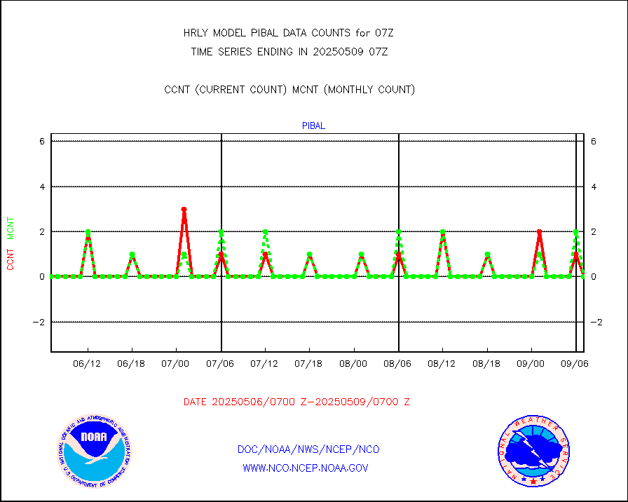
PIBAL (from PILOT, PILOT SHIP, PILOT MOBIL) |
0 |
0 |
n/a |
0106.50-0107.49 |
||||||||||
Multi-Agency Profiler (MAP) and SODAR winds |
46 |
48 |
95.8 % |
0106.50-0107.49 |
||||||||||
Rawinsonde - fixed land (from TEMP or PILOT) |
0 |
0 |
n/a |
0106.50-0107.49 |
||||||||||
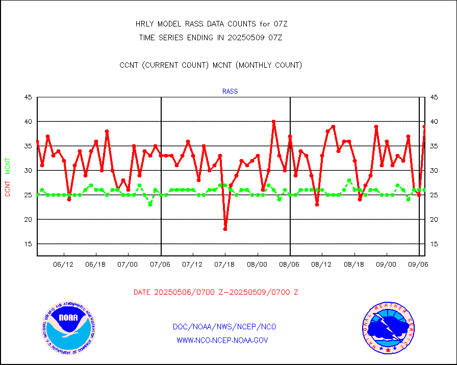
RASS temperatures (NOAA and Multi-Agency) |
28 |
25 |
112.0 % |
0106.50-0107.49 |
||||||||||
NEXRAD reflectivity (Lvl 2 - GTS) |
4204208 |
4022184 |
104.5 % |
0106.50-0107.49 |
||||||||||
NEXRAD radial wind (Level 2 - GTS) |
2268435 |
1772792 |
128.0 % |
0106.50-0107.49 |
||||||||||
METEOSAT-10 2nd Gen SEVIRI Clr Sky Radiance(proc) |
0 |
0 |
n/a |
0106.50-0107.49 |
||||||||||
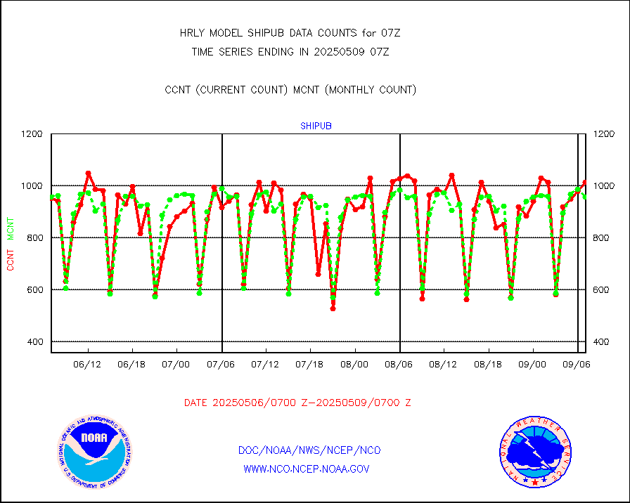
Ship - manual and automatic, restricted (BUFR) |
0 |
8 |
0.0 % |
0106.50-0107.50 |
||||||||||
Ship - manual and automatic, unrestricted |
171 |
175 |
97.7 % |
0106.50-0107.50 |
||||||||||
Ship - manual and automatic, unrestricted (BUFR) |
1019 |
1008 |
101.1 % |
0106.50-0107.50 |
||||||||||
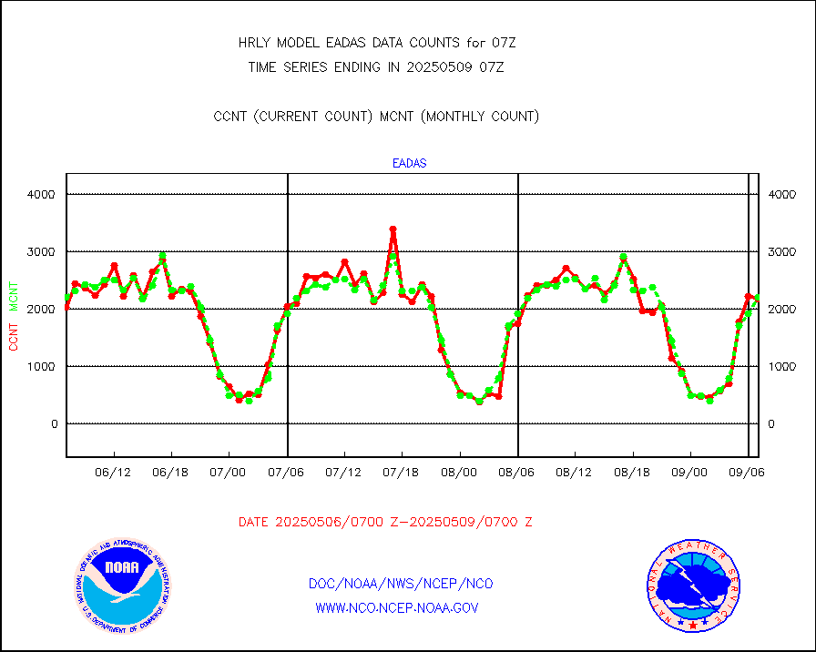
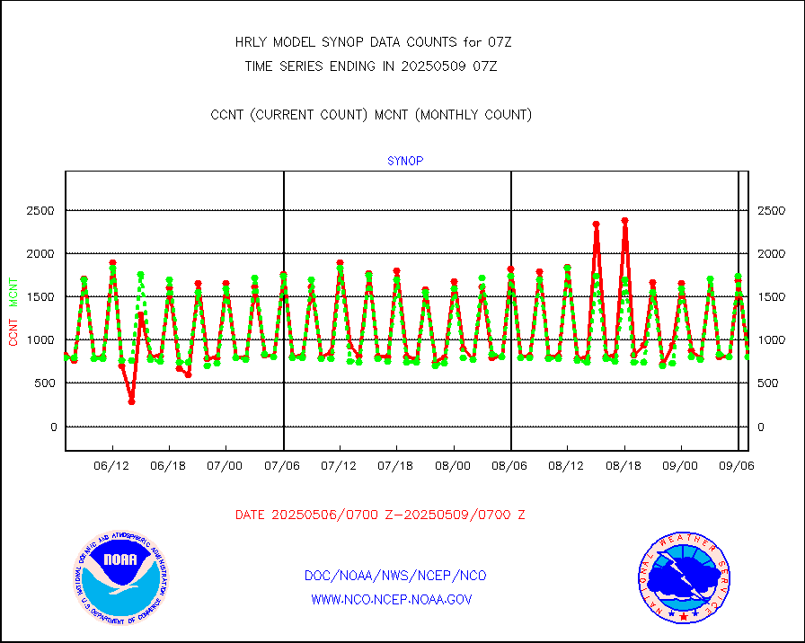
Synoptic - fixed manual and automatic |
807 |
744 |
108.5 % |
0106.50-0107.49 |
||||||||||
Synoptic - fixed manual & auto (decoded fr BUFR) |
5166 |
5142 |
100.5 % |
0106.50-0107.49 |
||||||||||
Synoptic - restricted (WMO Res 40) manual & auto. |
0 |
1 |
0.0 % |
0106.50-0107.49 |
||||||||||
Synoptic - restricted (WMO Res 40)(decoded BUFR) |
399 |
411 |
97.1 % |
0106.50-0107.49 |
||||||||||
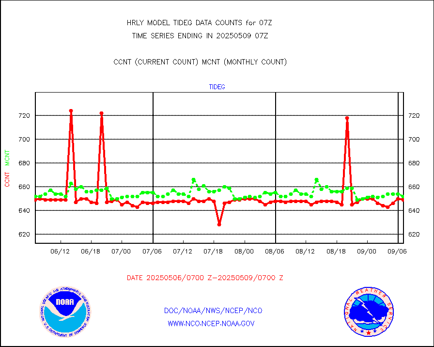
Tide gauge reports decoded from CREX format |
656 |
656 |
100.0 % |
0106.00-0106.99 |
||||||||||
| Data Types of Opportunity with Normal Counts | ||||||||||||||
|---|---|---|---|---|---|---|---|---|---|---|---|---|---|---|
| Type | Description | Hourly Count | Monthly Average | Percent (%) of Monthly Mean | UTC Time Window | |||||||||
GOES-16&up/NESDIS ir short-wv derived cld motion |
46232 |
47592 |
97.1 % |
0106.00-0106.99 |
||||||||||
MDCRS ACARS acft data (ARINC via AFWA)(AIREP fmt) |
0 |
0 |
n/a |
0106.50-0107.49 |
||||||||||
Himawari Clear Sky Radiance |
0 |
0 |
n/a |
0106.00-0106.99 |
||||||||||
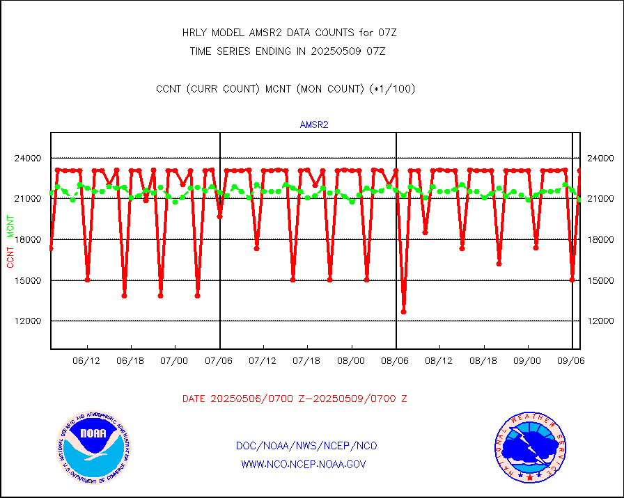
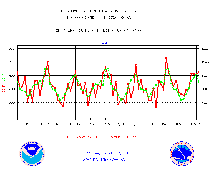
GCOM-W AMSR2 1B brightness temperatures |
2309472 |
2130689 |
108.4 % |
0105.00-0105.99 |
||||||||||
NPP/NOAA-20 ATMS bright. temps-direct b-cast SSEC |
93655 |
85934 |
109.0 % |
0105.50-0106.49 |
||||||||||
POES/NESDIS - processed ATOVS soundings/radiances |
0 |
0 |
n/a |
0105.00-0105.99 |
||||||||||
A.M.(N17,M2,M3) AVHRR GAC NCEP-proc clr&sea btmps |
1276963 |
1238912 |
103.1 % |
0104.50-0105.49 |
||||||||||
eXpendable BathyThermograph, mooring (BATHY fmt) |
0 |
0 |
n/a |
0100.00-0100.99 |
||||||||||
Coop/MADIS NEPP & HCN-Modernization NOAA COOP Obs |
11 |
11 |
100.0 % |
0106.50-0107.49 |
||||||||||
NPP/NOAA-20 CrIS full spctrl radn (431 ch subset) |
240534 |
233615 |
103.0 % |
0105.50-0106.49 |
||||||||||
NPP/NOAA-20 CrIS full spctrl radn dir brdcst SSEC |
52470 |
58666 |
89.4 % |
0105.50-0106.49 |
||||||||||
Coast Guard |
5 |
5 |
100.0 % |
0106.50-0107.50 |
||||||||||
Drifting buoys (decoded from BUFR) |
1449 |
1415 |
102.4 % |
0106.50-0107.50 |
||||||||||
Dropwinsonde (from TEMP DROP) |
0 |
0 |
n/a |
0106.50-0107.49 |
||||||||||
Dropwinsonde (decoded from BUFR) |
1 |
1 |
100.0 % |
0106.51-0107.49 |
||||||||||
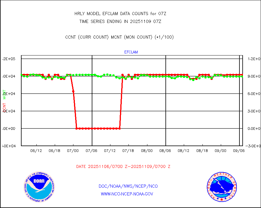
GOES imager effective cloud amount data (U.Wisc.) |
9250602 |
8633895 |
107.1 % |
0106.50-0107.49 |
||||||||||
NPP Adv. Tech. MW Sndr (ATMS) br. temps from RARS |
65713 |
76484 |
85.9 % |
0105.50-0106.49 |
||||||||||
NOAA 18-19 & METOP 1-2 MHS proc. btemps from RARS |
24570 |
81529 |
30.1 % |
0106.50-0107.49 |
||||||||||
GOES/NESDIS (11x17 f-o-v) imager clear radiances |
0 |
0 |
n/a |
0106.00-0106.99 |
||||||||||
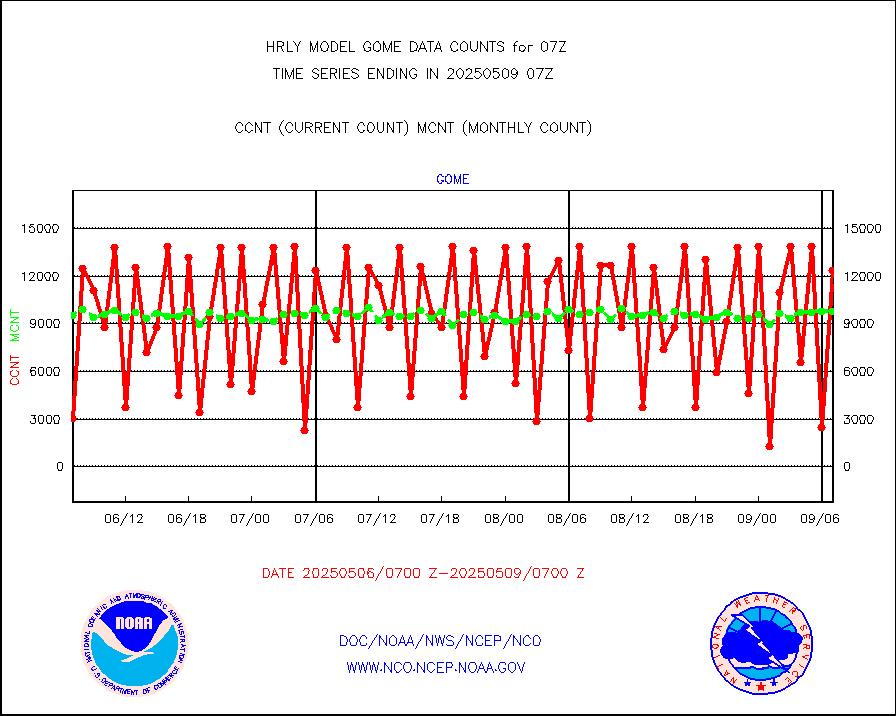
METOP 1-2 Global Ozone Monitoring Exp.-2 (GOME-2) |
12768 |
8961 |
142.5 % |
0105.50-0106.49 |
||||||||||
GOES-16&up/NESDIS wv imgr/deep-lyr derivd cld mtn |
19710 |
16941 |
116.3 % |
0106.00-0106.99 |
||||||||||
METEOSAT/EUMETSAT wvpr imgr drv cld motion NBseq |
34878 |
35790 |
97.5 % |
0105.50-0106.49 |
||||||||||
High Density OBs from reconnaissance acft data |
0 |
4 |
0.0 % |
0106.50-0107.49 |
||||||||||
METOP 1-2 IASI 1C radiances-direct broadcast SSEC |
54299 |
42041 |
129.2 % |
0105.50-0106.49 |
||||||||||
VIIRS (NPP/NOAA-20) ir lg-wv drv cloud motion(NB) |
26230 |
21062 |
124.5 % |
0103.00-0103.99 |
||||||||||
AVHRR (NOAA/METOP) ir lg-wave derived cld motion |
0 |
0 |
n/a |
0103.00-0103.99 |
||||||||||
AVHRR (METOP) ir lg-wave derived cld motion |
0 |
0 |
n/a |
0106.50-0107.50 |
||||||||||
INSAT/KALPANA India ir lg-wave derived cld motion |
0 |
0 |
n/a |
0104.50-0105.49 |
||||||||||
Korean AMDAR aircraft data (decoded from BUFR) |
82 |
48 |
170.8 % |
0106.50-0107.49 |
||||||||||
Land-based CMAN stations decoded from CMAN format |
38 |
77 |
49.4 % |
0106.50-0107.49 |
||||||||||
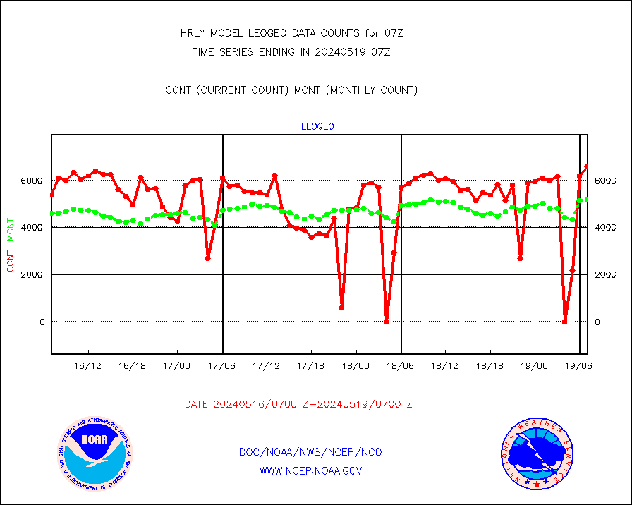
LEO-GEO satellite AMVs from UWisc. |
7361 |
7795 |
94.4 % |
0103.00-0103.99 |
||||||||||
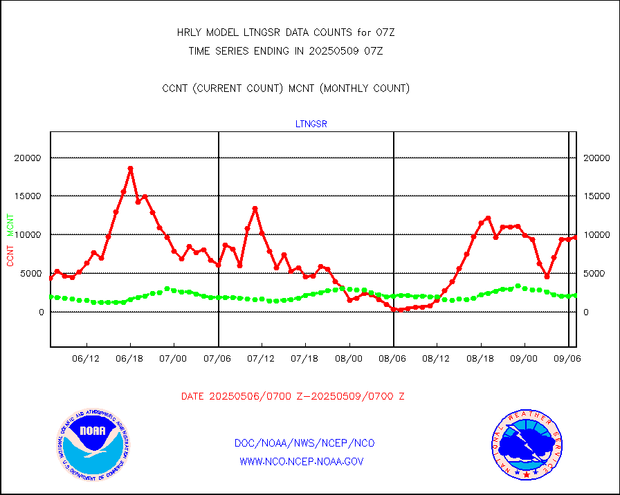
LLDN Long-rng lightning from Vaisala via NOAAPORT |
170630 |
152918 |
111.6 % |
0106.50-0107.49 |
||||||||||
NLDN Shrt-rng lightning from Vaisala via NOAAPORT |
3682 |
4278 |
86.1 % |
0106.50-0107.49 |
||||||||||
Moored buoys (decoded from BUFR) |
967 |
932 |
103.8 % |
0106.50-0107.50 |
||||||||||
Aura Microwave Limb Sounder (MLS) ozone data |
0 |
0 |
n/a |
0105.00-0105.99 |
||||||||||
Mesonet/MADIS UrbaNet |
3587 |
3558 |
100.8 % |
0106.50-0107.49 |
||||||||||
NEXRAD Vel Azm Dsp(VAD) winds via Level 2 decoder |
586 |
575 |
101.9 % |
0106.50-0107.49 |
||||||||||
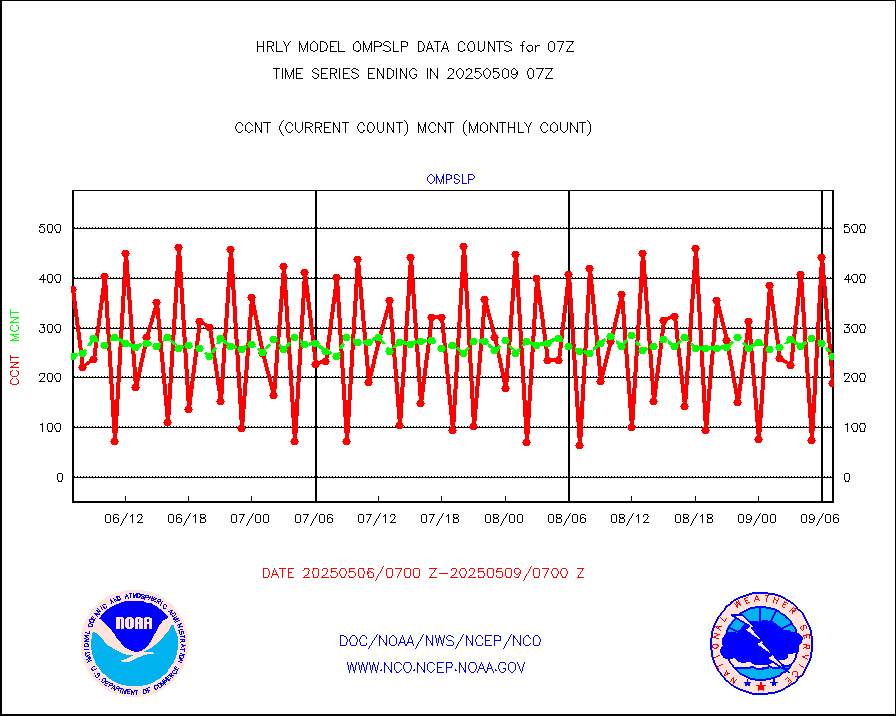
OMPS Limb Profiler ozone data (NPP) |
115 |
264 |
43.6 % |
0100.00-0100.99 |
||||||||||
OMPS nadir profile ozone (Version 8 BUFR) |
490 |
561 |
87.3 % |
0105.00-0105.99 |
||||||||||
OMPS total column ozone (Version 8 BUFR) |
396181 |
333496 |
118.8 % |
0105.00-0105.99 |
||||||||||
PIBAL (decoded from BUFR) |
0 |
0 |
n/a |
0106.51-0107.49 |
||||||||||
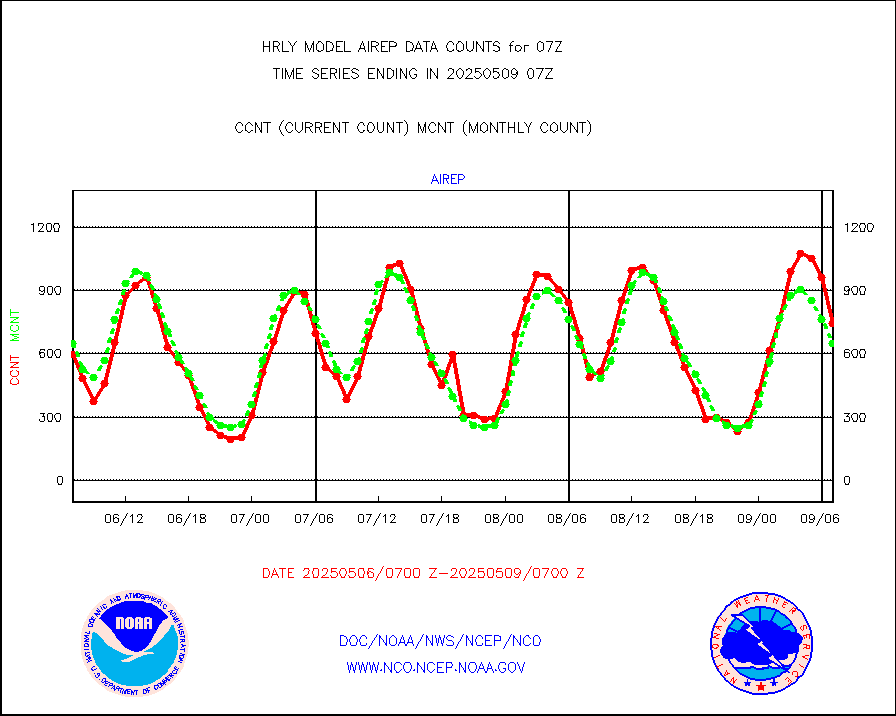
Manual PIREP aircraft data (dcded from AIREP fmt) |
9 |
9 |
100.0 % |
0106.50-0107.49 |
||||||||||
Profilr winds from PIBAL (PILOT,PILOT SHIP/MOBIL) |
0 |
0 |
n/a |
0106.50-0107.49 |
||||||||||
Rawinsonde - fixed land (decoded from BUFR) |
1 |
1 |
100.0 % |
0106.51-0107.49 |
||||||||||
Rawinsonde - mobile land (from TEMP/PILOT MOBIL) |
0 |
0 |
n/a |
0106.50-0107.49 |
||||||||||
Rawinsonde - mobile land (decoded from BUFR) |
0 |
0 |
n/a |
0106.51-0107.49 |
||||||||||
Rawinsonde - ship (from TEMP SHIP, PILOT SHIP) |
0 |
0 |
n/a |
0106.50-0107.49 |
||||||||||
Rawinsonde - ship (decoded from BUFR) |
0 |
0 |
n/a |
0106.51-0107.49 |
||||||||||
Flight level reconnaissance aircraft data |
0 |
0 |
n/a |
0106.50-0107.49 |
||||||||||
Megha-Tropiques SAPHIR L1A2 brightness temps |
0 |
0 |
n/a |
0104.50-0105.49 |
||||||||||
METEOSAT-10 2nd Gen SEVIRI All Sky Radiance(proc) |
75512 |
75346 |
100.2 % |
0106.50-0107.49 |
||||||||||
Ship - manual and automatic, restricted |
19 |
15 |
126.7 % |
0106.50-0107.49 |
||||||||||
DMSP SSM/IS 1C radiance data (Unified Pre-Proc.) |
112680 |
112788 |
99.9 % |
0105.50-0106.49 |
||||||||||
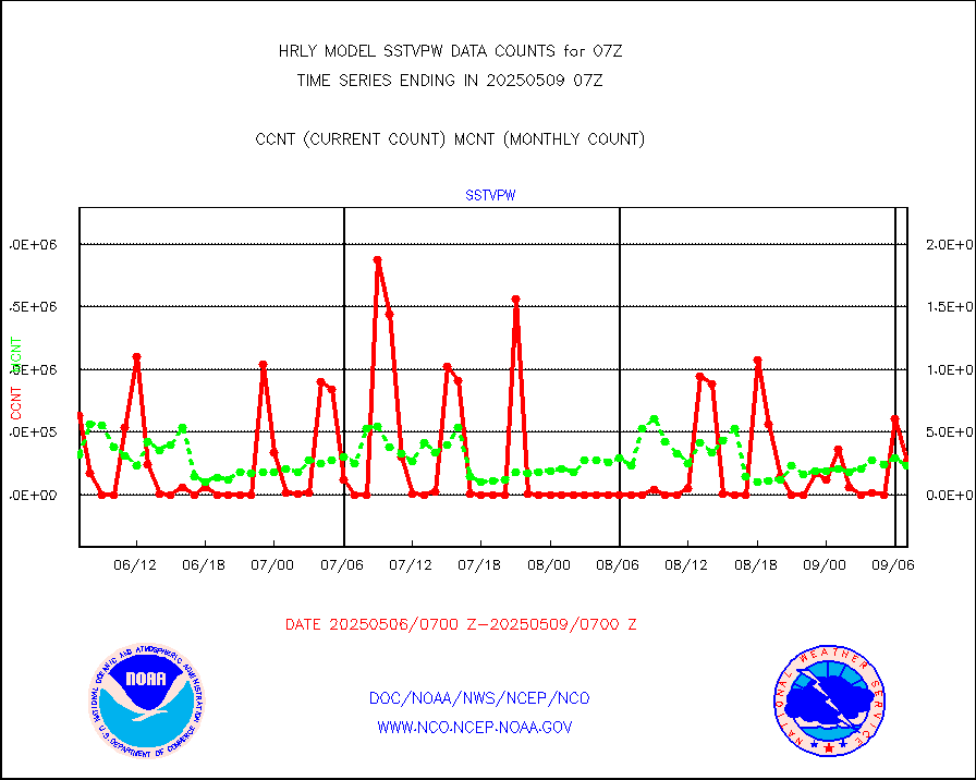
NPP/NOAA-20 VIIRS SST - CLEAR & OVER WATER |
4855096 |
1314914 |
369.2 % |
0106.50-0107.49 |
||||||||||
NPP/NOAA-20 VIIRS SST - PROBABLY CLR & OVER WATER |
1001542 |
364526 |
274.8 % |
0106.50-0107.49 |
||||||||||
Synoptic - mobile manual and automatic |
797 |
723 |
110.2 % |
0106.50-0107.49 |
||||||||||
Synoptic - mobile manual & auto (decoded fr BUFR) |
3 |
1 |
300.0 % |
0106.50-0107.49 |
||||||||||
CTD probe, Argo prflng float, mooring (TESAC fmt) |
215 |
214 |
100.5 % |
0106.50-0107.49 |
||||||||||
TAMDAR aircft data-all types(from Panasonic,BUFR) |
55 |
36 |
152.8 % |
0106.50-0107.49 |
||||||||||
ThermoSalinoGraph (TSG) TRACKOB format) |
91 |
98 |
92.9 % |
0105.50-0106.49 |
||||||||||
INSAT/KALPANA India visible derived cloud motion |
0 |
0 |
n/a |
0104.50-0105.49 |
||||||||||
MTSAT/JMA visible derived cloud motion |
10920 |
10649 |
102.5 % |
0104.50-0105.49 |
||||||||||
GOES-16&up/NESDIS visible derived cloud motion |
5957 |
3636 |
163.8 % |
0106.00-0106.99 |
||||||||||
METEOSAT/EUMETSAT visible drv cld motion NBseq |
30759 |
27773 |
110.8 % |
0105.50-0106.49 |
||||||||||


