| Suspect Data Shortages in Critical Types - Monitor | ||||||||||||||
|---|---|---|---|---|---|---|---|---|---|---|---|---|---|---|
| Type | Description | Hourly Count | Monthly Average | Percent (%) of Monthly Mean | UTC Time Window | |||||||||
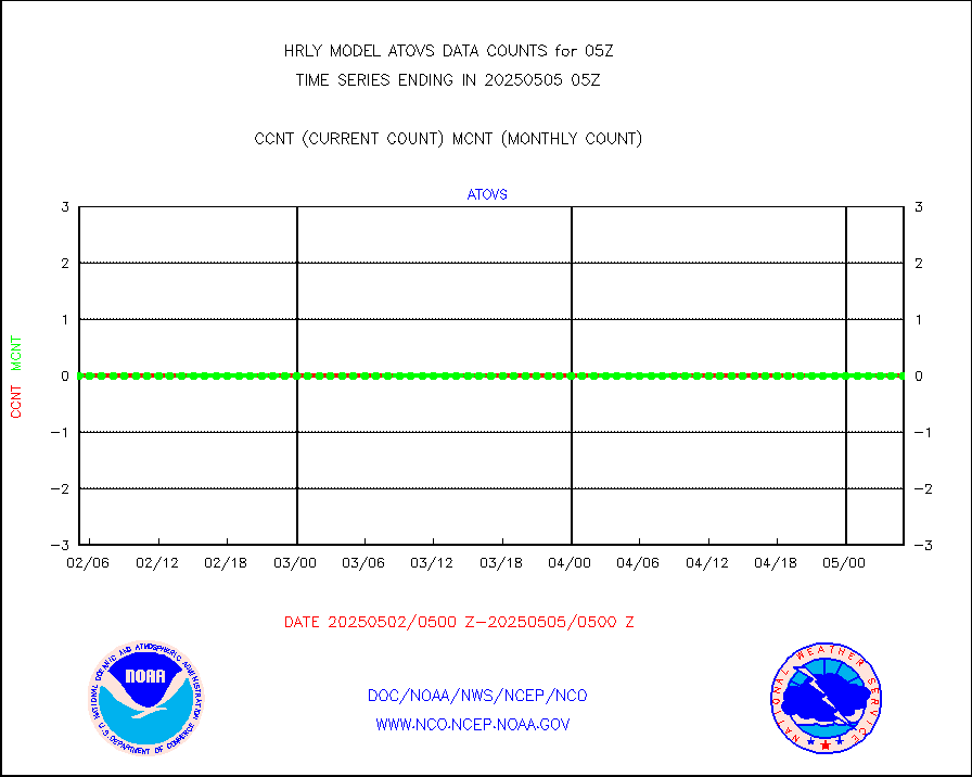
NOAA 18-19 & METOP 1-2 HIRS-4 NCEP-proc. br.temps |
0 |
11887 |
0.0 % |
0203.00-0203.99 |
||||||||||
NOAA 15-19 & METOP 1-2 HIRS-3/4 pr btmps frm RARS |
0 |
8345 |
0.0 % |
0204.50-0205.49 |
||||||||||
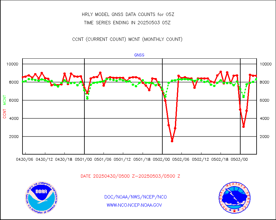
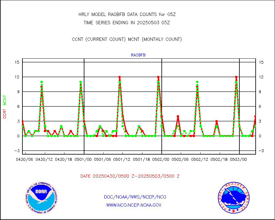
Grnd-based Gbl Navigation Sat System (GNSS) data |
1362 |
6602 |
20.6 % |
0204.00-0204.99 |
||||||||||
| Shortage in Data Type of Opportunity - Monitor | ||||||||||||||
|---|---|---|---|---|---|---|---|---|---|---|---|---|---|---|
| Type | Description | Hourly Count | Monthly Average | Percent (%) of Monthly Mean | UTC Time Window | |||||||||
P.M.(N18-19) AVHRR GAC NCEP-proc clr & sea btemps |
0 |
240454 |
0.0 % |
0202.50-0203.49 |
||||||||||
INDIA SATWIND, INSAT WV channel |
0 |
862 |
0.0 % |
0204.00-0204.99 |
||||||||||
INDIA SATWIND, INSAT IR channel |
0 |
762 |
0.0 % |
0204.00-0204.99 |
||||||||||
INDIA SATWIND, INSAT VIS channel |
0 |
12 |
0.0 % |
0204.00-0204.99 |
||||||||||
| Critical Data with Normal Counts | ||||||||||||||
|---|---|---|---|---|---|---|---|---|---|---|---|---|---|---|
| Type | Description | Hourly Count | Monthly Average | Percent (%) of Monthly Mean | UTC Time Window | |||||||||
NOAA 15-19 & METOP 1-2 AMSU-A NCEP-proc. br.temps |
26736 |
32597 |
82.0 % |
0203.00-0203.99 |
||||||||||
NOAA 18-19 & METOP 1-2 MHS NCEP-proces. br. temps |
237887 |
263597 |
90.2 % |
0203.00-0203.99 |
||||||||||
MDCRS ACARS acft data from ARINC(dcded from BUFR) |
16746 |
22327 |
75.0 % |
0204.50-0205.49 |
||||||||||
Manual AIREP aircraft data (dcded from AIREP fmt) |
982 |
1011 |
97.1 % |
0204.50-0205.49 |
||||||||||
AQUA AIRS/AMSU-A/HSB brightness temps- every FOV |
0 |
0 |
n/a |
0202.50-0203.49 |
||||||||||
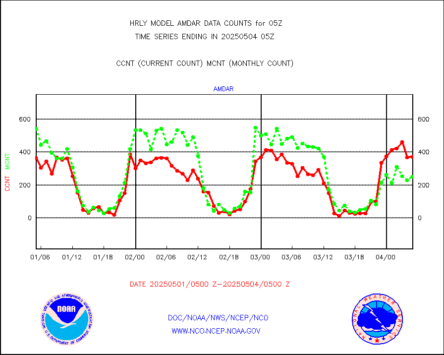
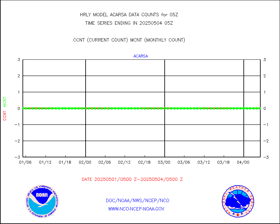
AMDAR aircraft data (decoded from AMDAR format) |
382 |
184 |
207.6 % |
0204.50-0205.49 |
||||||||||
AMDAR aircraft data (decoded from BUFR) |
3063 |
2912 |
105.2 % |
0204.50-0205.49 |
||||||||||
METOP 1-2 ASCAT products |
64260 |
58839 |
109.2 % |
0203.50-0204.49 |
||||||||||
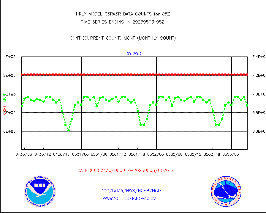
NPP/NOAA-20 ATMS brightness temperatures |
362688 |
341498 |
106.2 % |
0203.50-0204.49 |
||||||||||
Canadian AMDAR aircraft data (decoded from BUFR) |
0 |
0 |
n/a |
0204.50-0205.49 |
||||||||||
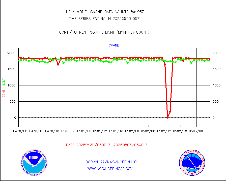
Surface Marine CMAN rpts decoded from BUFR format |
1878 |
1865 |
100.7 % |
0204.50-0205.50 |
||||||||||
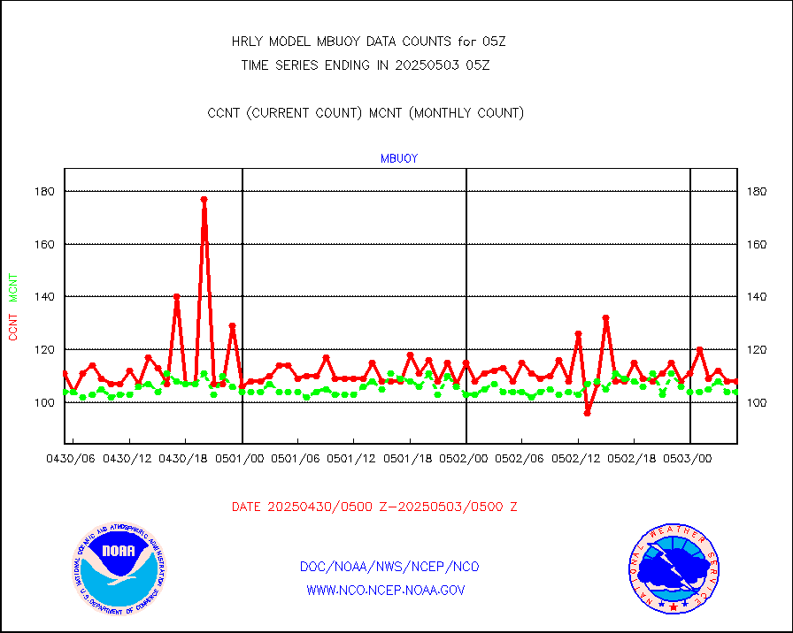
Buoys decoded from FM-18 fmt (moored or drifting) |
13 |
17 |
76.5 % |
0204.50-0205.49 |
||||||||||
E-AMDAR (European AMDAR acft decoded from BUFR) |
1433 |
1651 |
86.8 % |
0204.50-0205.49 |
||||||||||
NOAA 15-19 & METOP 1-2 AMSU-A proc btmps frm RARS |
10170 |
11476 |
88.6 % |
0204.50-0205.49 |
||||||||||
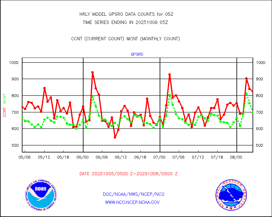
GPS radio occultation data |
544 |
545 |
99.8 % |
0202.50-0203.49 |
||||||||||
GOES-16/17 All Sky Radiances (proc.) |
720952 |
720791 |
100.0 % |
0204.50-0205.49 |
||||||||||
GOES-16/17 Clear Sky Radiances (proc.) |
344362 |
355079 |
97.0 % |
0204.50-0205.49 |
||||||||||
MTSAT/JMA water vapor imager derived cloud motion |
21516 |
19813 |
108.6 % |
0202.50-0203.49 |
||||||||||
MODIS (AQUA/TERRA) wvpr imager derived cld motion |
0 |
0 |
n/a |
0201.00-0201.99 |
||||||||||
GOES-16&up/NESDIS wv imgr/cld-top derived cld mtn |
25633 |
27268 |
94.0 % |
0204.00-0204.99 |
||||||||||
METEOSAT/EUMETSAT ir lg-wave drv cld motion NBseq |
21947 |
21057 |
104.2 % |
0203.50-0204.49 |
||||||||||
MTSAT/JMA infrared long-wave derived cloud motion |
16800 |
16143 |
104.1 % |
0202.50-0203.49 |
||||||||||
MODIS (AQUA/TERRA) ir l-wave derived cloud motion |
0 |
0 |
n/a |
0201.00-0201.99 |
||||||||||
GOES-16&up/NESDIS ir long-wave derived cld motion |
80256 |
82647 |
97.1 % |
0204.00-0204.99 |
||||||||||
GOES/NASA(Langley) hi-res. (1x1 f-o-v) cloud data |
6431638 |
6401514 |
100.5 % |
0204.50-0205.49 |
||||||||||
Buoys decoded from FM-13 format (moored) |
123 |
120 |
102.5 % |
0204.50-0205.49 |
||||||||||
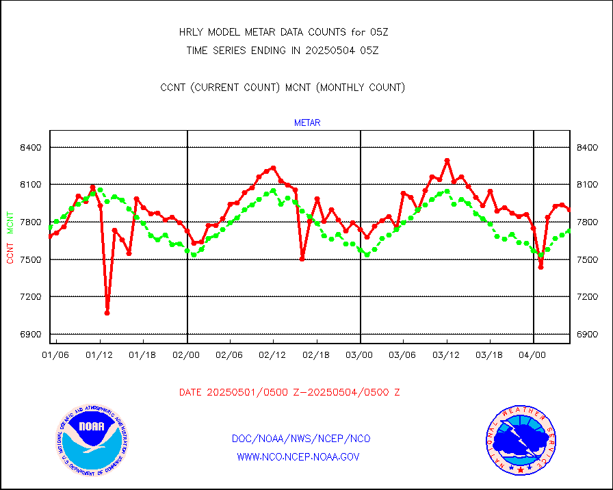
Aviation - METAR |
7767 |
7732 |
100.5 % |
0204.50-0205.49 |
||||||||||
Mesonet/MADIS Colorado E-470 (Interstate 470) |
24 |
23 |
104.3 % |
0204.50-0205.49 |
||||||||||
Mesonet/MADIS Alaska Department of Transportation |
118 |
83 |
142.2 % |
0204.50-0205.49 |
||||||||||
Mesonet/MADIS U.S. Army Aberdeen Proving Grounds |
0 |
0 |
n/a |
0204.50-0205.49 |
||||||||||
Mesonet/MADIS Citizen Weather Observers Program |
51223 |
57422 |
89.2 % |
0204.50-0205.49 |
||||||||||
Mesonet/MADIS AWS Convergence Technologies, Inc. |
17081 |
19651 |
86.9 % |
0204.50-0205.49 |
||||||||||
Mesonet/MADIS "Anything Weather" |
0 |
0 |
n/a |
0204.50-0205.49 |
||||||||||
Mesonet/MADIS Colorado Dept. of Transportation |
0 |
0 |
n/a |
0204.50-0205.49 |
||||||||||
Mesonet/MADIS DC Net |
0 |
0 |
n/a |
0204.50-0205.49 |
||||||||||
Mesonet/MADIS Denver Urban Drainage & Flood Cntrl |
0 |
0 |
n/a |
0204.50-0205.49 |
||||||||||
Mesonet/MADIS Florida (FAWN & USF) |
0 |
0 |
n/a |
0204.50-0205.49 |
||||||||||
Mesonet/MADIS Florida Dept. of Transportation |
0 |
0 |
n/a |
0204.50-0205.49 |
||||||||||
Mesonet/MADIS Georgia Dept. of Transportation |
0 |
0 |
n/a |
0204.50-0205.49 |
||||||||||
Mesonet/MADIS NWS Hydromet Auto Data System(HADS) |
5806 |
6175 |
94.0 % |
0204.50-0205.49 |
||||||||||
Mesonet/MADIS Iowa Environmental |
176 |
184 |
95.7 % |
0204.50-0205.49 |
||||||||||
Mesonet/MADIS Indiana Dept. of Transportation |
0 |
0 |
n/a |
0204.50-0205.49 |
||||||||||
Mesonet/MADIS Iowa Department of Transportation |
0 |
0 |
n/a |
0204.50-0205.49 |
||||||||||
Mesonet/MADIS Kansas Department of Transportation |
370 |
351 |
105.4 % |
0204.50-0205.49 |
||||||||||
Mesonet/MADIS Oklahoma Mesonet |
630 |
609 |
103.4 % |
0204.50-0205.49 |
||||||||||
Mesonet/MADIS Louisiana State/Jackson State Univ. |
0 |
0 |
n/a |
0204.50-0205.49 |
||||||||||
Mesonet/MADIS Missouri Commercial Agricult Wx Net |
333 |
333 |
100.0 % |
0204.50-0205.49 |
||||||||||
Mesonet/MADIS Minnesota Dept. of Transportation |
0 |
0 |
n/a |
0204.50-0205.49 |
||||||||||
Mesonet/MADIS NOS-Phys Oceanographic Realtime Sys |
336 |
381 |
88.2 % |
0204.50-0205.49 |
||||||||||
Mesonet/MADIS NFIC Remote Automated Wx Stns(RAWS) |
1929 |
1798 |
107.3 % |
0204.50-0205.49 |
||||||||||
Mesonet/MADIS many providers, not separated out |
61302 |
70023 |
87.5 % |
0204.00-0205.49 |
||||||||||
Mesonet/MADIS Virginia Dept. of Transportation |
0 |
0 |
n/a |
0204.50-0205.49 |
||||||||||
Mesonet/MADIS "Weather for You" |
0 |
0 |
n/a |
0204.50-0205.49 |
||||||||||
Mesonet/MADIS Wisconsin Dept. of Transportation |
0 |
0 |
n/a |
0204.50-0205.49 |
||||||||||
Mesonet/MADIS MesoWest (many subproviders) |
25665 |
34051 |
75.4 % |
0204.50-0205.49 |
||||||||||
Mesonet/MADIS West Texas |
5658 |
6136 |
92.2 % |
0204.50-0205.49 |
||||||||||
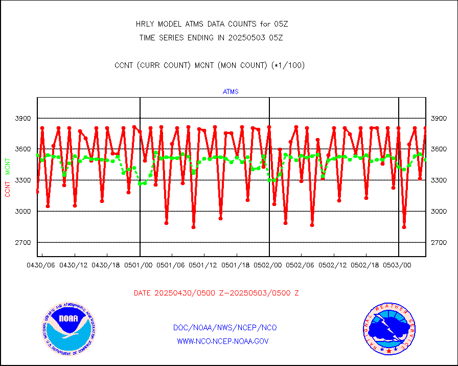
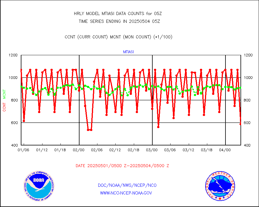
METOP 1-2 IASI 1C radiance data (varbl. channels) |
106924 |
89475 |
119.5 % |
0203.00-0203.99 |
||||||||||
NEXRAD Vel Azm Dsp(VAD) winds via radar coded msg |
0 |
0 |
n/a |
0204.50-0205.49 |
||||||||||
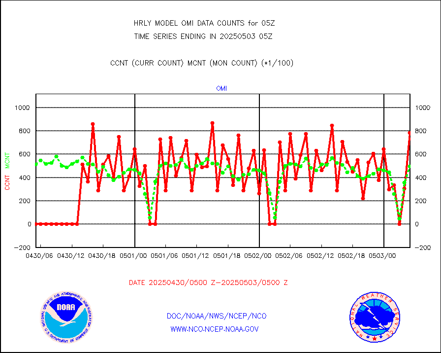
Aura Ozone Monitoring Instrument (OMI) data |
0 |
0 |
n/a |
0202.50-0203.49 |
||||||||||
NOAA 16-19 Solar Backscatter UV-2 rad frm V8 BUFR |
0 |
0 |
n/a |
0203.00-0203.99 |
||||||||||
PIBAL (from PILOT, PILOT SHIP, PILOT MOBIL) |
0 |
0 |
n/a |
0204.50-0205.49 |
||||||||||
Multi-Agency Profiler (MAP) and SODAR winds |
44 |
48 |
91.7 % |
0204.50-0205.49 |
||||||||||
Rawinsonde - fixed land (from TEMP or PILOT) |
0 |
0 |
n/a |
0204.50-0205.49 |
||||||||||
RASS temperatures (NOAA and Multi-Agency) |
22 |
24 |
91.7 % |
0204.50-0205.49 |
||||||||||
NEXRAD reflectivity (Lvl 2 - GTS) |
4189081 |
4121909 |
101.6 % |
0204.50-0205.49 |
||||||||||
NEXRAD radial wind (Level 2 - GTS) |
2191281 |
2001688 |
109.5 % |
0204.50-0205.49 |
||||||||||
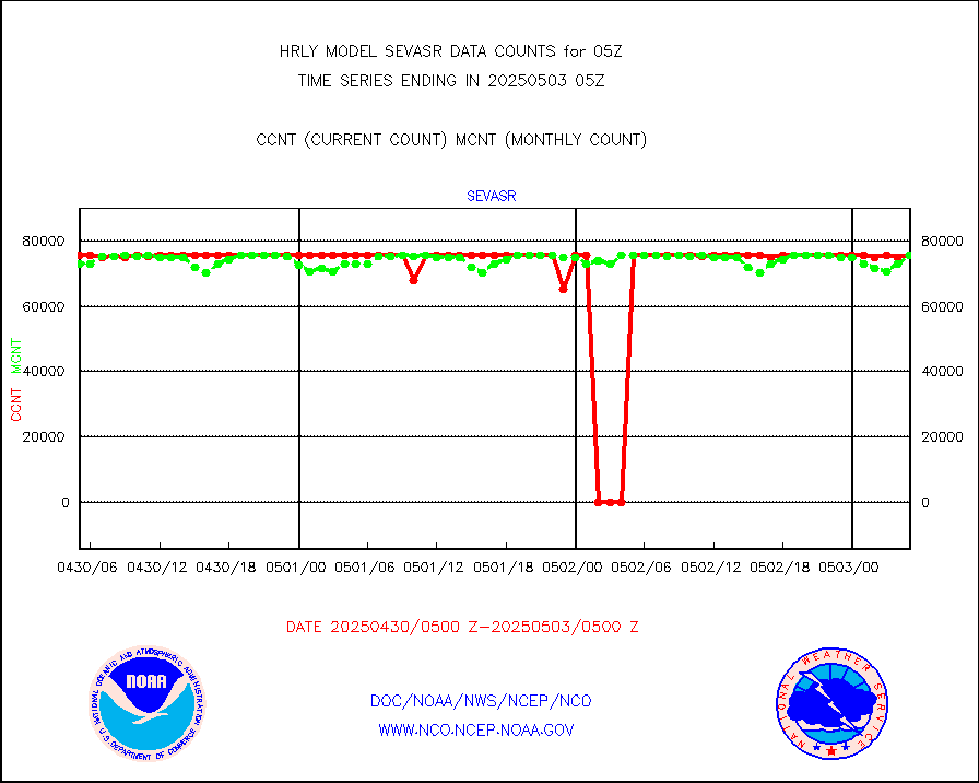
METEOSAT-10 2nd Gen SEVIRI Clr Sky Radiance(proc) |
0 |
0 |
n/a |
0204.50-0205.49 |
||||||||||
Ship - manual and automatic, restricted (BUFR) |
9 |
10 |
90.0 % |
0204.50-0205.50 |
||||||||||
Ship - manual and automatic, unrestricted |
194 |
175 |
110.9 % |
0204.50-0205.50 |
||||||||||
Ship - manual and automatic, unrestricted (BUFR) |
1018 |
1012 |
100.6 % |
0204.50-0205.50 |
||||||||||
Synoptic - fixed manual and automatic |
720 |
759 |
94.9 % |
0204.50-0205.49 |
||||||||||
Synoptic - fixed manual & auto (decoded fr BUFR) |
5185 |
5133 |
101.0 % |
0204.50-0205.49 |
||||||||||
Synoptic - restricted (WMO Res 40) manual & auto. |
1 |
0 |
n/a |
0204.50-0205.49 |
||||||||||
Synoptic - restricted (WMO Res 40)(decoded BUFR) |
344 |
410 |
83.9 % |
0204.50-0205.49 |
||||||||||
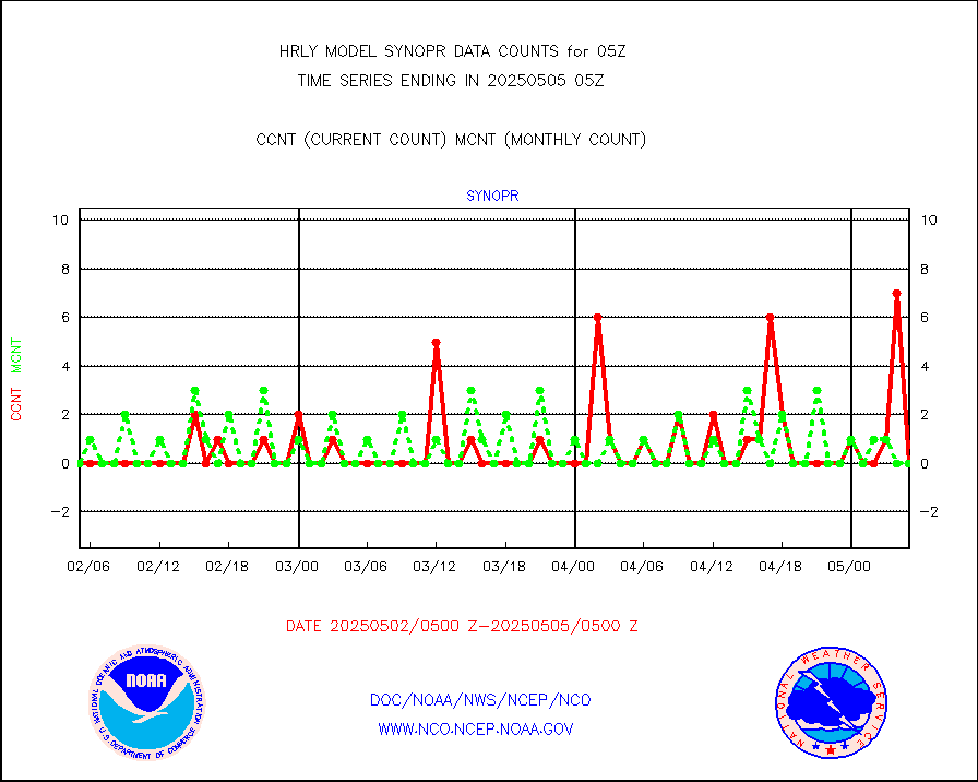
Tide gauge reports decoded from CREX format |
662 |
656 |
100.9 % |
0204.00-0204.99 |
||||||||||
| Data Types of Opportunity with Normal Counts | ||||||||||||||
|---|---|---|---|---|---|---|---|---|---|---|---|---|---|---|
| Type | Description | Hourly Count | Monthly Average | Percent (%) of Monthly Mean | UTC Time Window | |||||||||
GOES-16&up/NESDIS ir short-wv derived cld motion |
37078 |
39255 |
94.5 % |
0204.00-0204.99 |
||||||||||
MDCRS ACARS acft data (ARINC via AFWA)(AIREP fmt) |
0 |
0 |
n/a |
0204.50-0205.49 |
||||||||||
Himawari Clear Sky Radiance |
0 |
0 |
n/a |
0204.00-0204.99 |
||||||||||
GCOM-W AMSR2 1B brightness temperatures |
2309472 |
2189430 |
105.5 % |
0203.00-0203.99 |
||||||||||
NPP/NOAA-20 ATMS bright. temps-direct b-cast SSEC |
142101 |
104345 |
136.2 % |
0203.50-0204.49 |
||||||||||
POES/NESDIS - processed ATOVS soundings/radiances |
0 |
0 |
n/a |
0203.00-0203.99 |
||||||||||
A.M.(N17,M2,M3) AVHRR GAC NCEP-proc clr&sea btmps |
908961 |
870285 |
104.4 % |
0202.50-0203.49 |
||||||||||
eXpendable BathyThermograph, mooring (BATHY fmt) |
0 |
0 |
n/a |
0122.00-0122.99 |
||||||||||
Coop/MADIS NEPP & HCN-Modernization NOAA COOP Obs |
11 |
11 |
100.0 % |
0204.50-0205.49 |
||||||||||
NPP/NOAA-20 CrIS full spctrl radn (431 ch subset) |
240534 |
235084 |
102.3 % |
0203.50-0204.49 |
||||||||||
NPP/NOAA-20 CrIS full spctrl radn dir brdcst SSEC |
81054 |
74457 |
108.9 % |
0203.50-0204.49 |
||||||||||
Coast Guard |
5 |
5 |
100.0 % |
0204.50-0205.50 |
||||||||||
Drifting buoys (decoded from BUFR) |
1465 |
1447 |
101.2 % |
0204.50-0205.50 |
||||||||||
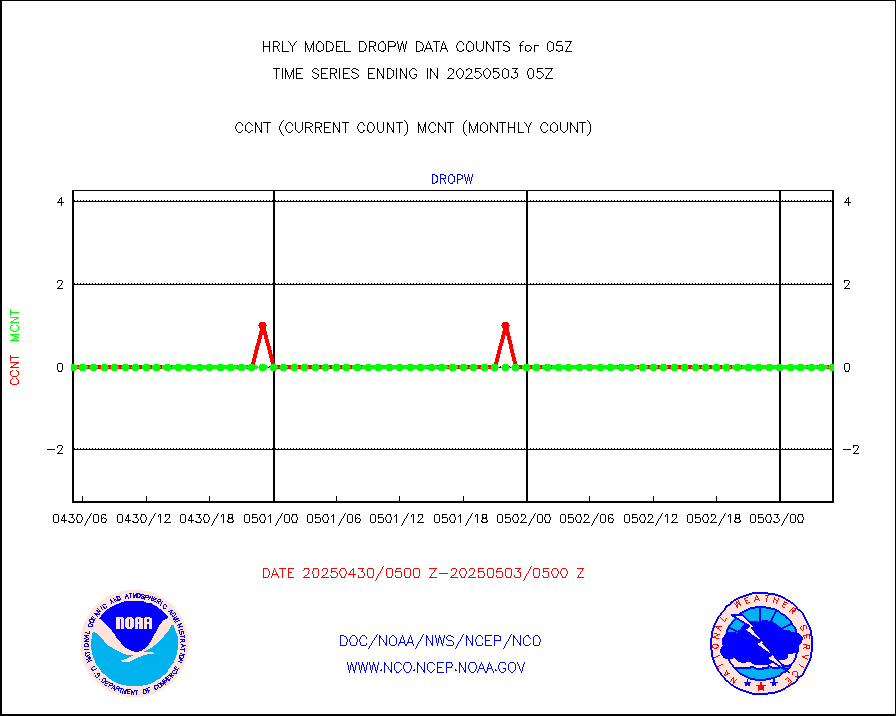
Dropwinsonde (from TEMP DROP) |
0 |
0 |
n/a |
0204.50-0205.49 |
||||||||||
Dropwinsonde (decoded from BUFR) |
0 |
0 |
n/a |
0204.51-0205.49 |
||||||||||
GOES imager effective cloud amount data (U.Wisc.) |
9250602 |
8633895 |
107.1 % |
0204.50-0205.49 |
||||||||||
NPP Adv. Tech. MW Sndr (ATMS) br. temps from RARS |
77425 |
78676 |
98.4 % |
0203.50-0204.49 |
||||||||||
METOP 1-2 IASI 1C radiance data vbl chn from RARS |
0 |
937 |
0.0 % |
0204.00-0204.99 |
||||||||||
NOAA 18-19 & METOP 1-2 MHS proc. btemps from RARS |
84330 |
111872 |
75.4 % |
0204.50-0205.49 |
||||||||||
GOES/NESDIS (11x17 f-o-v) imager clear radiances |
0 |
0 |
n/a |
0204.00-0204.99 |
||||||||||
METOP 1-2 Global Ozone Monitoring Exp.-2 (GOME-2) |
12354 |
9493 |
130.1 % |
0203.50-0204.49 |
||||||||||
GOES-16&up/NESDIS wv imgr/deep-lyr derivd cld mtn |
19646 |
17094 |
114.9 % |
0204.00-0204.99 |
||||||||||
METEOSAT/EUMETSAT wvpr imgr drv cld motion NBseq |
33345 |
36204 |
92.1 % |
0203.50-0204.49 |
||||||||||
High Density OBs from reconnaissance acft data |
0 |
4 |
0.0 % |
0204.50-0205.49 |
||||||||||
METOP 1-2 IASI 1C radiances-direct broadcast SSEC |
75301 |
63872 |
117.9 % |
0203.50-0204.49 |
||||||||||
VIIRS (NPP/NOAA-20) ir lg-wv drv cloud motion(NB) |
24225 |
21001 |
115.4 % |
0201.00-0201.99 |
||||||||||
AVHRR (NOAA/METOP) ir lg-wave derived cld motion |
0 |
0 |
n/a |
0201.00-0201.99 |
||||||||||
AVHRR (METOP) ir lg-wave derived cld motion |
0 |
0 |
n/a |
0204.50-0205.50 |
||||||||||
INSAT/KALPANA India ir lg-wave derived cld motion |
0 |
0 |
n/a |
0202.50-0203.49 |
||||||||||
Korean AMDAR aircraft data (decoded from BUFR) |
70 |
49 |
142.9 % |
0204.50-0205.49 |
||||||||||
Land-based CMAN stations decoded from CMAN format |
68 |
79 |
86.1 % |
0204.50-0205.49 |
||||||||||
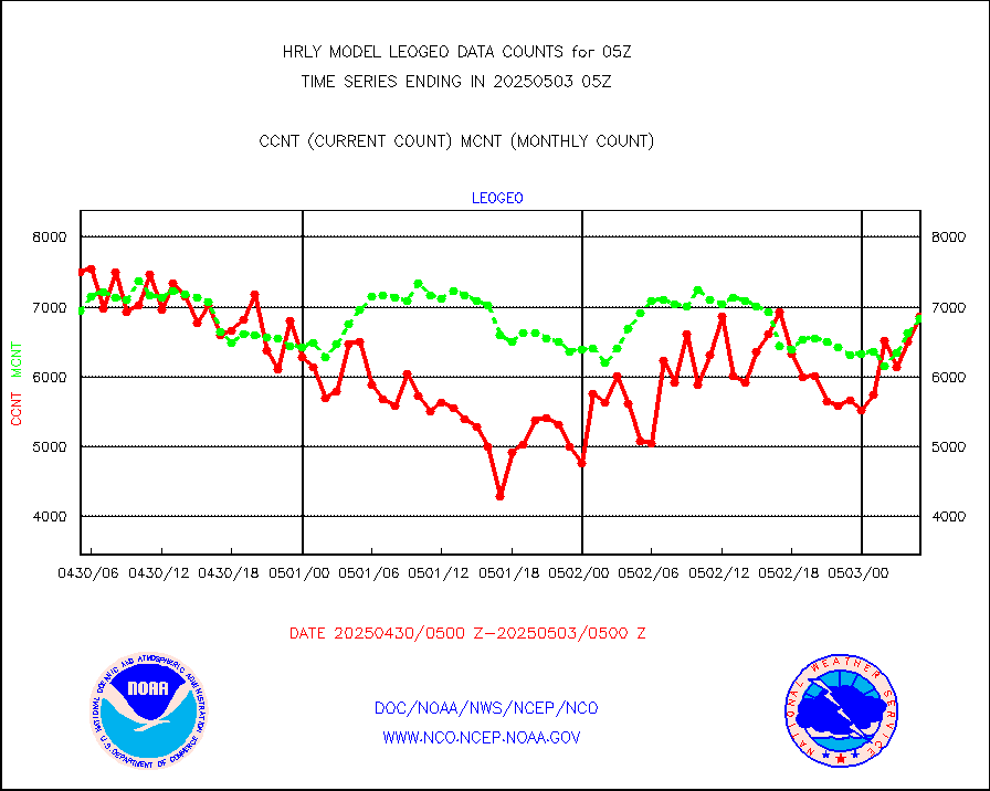
LEO-GEO satellite AMVs from UWisc. |
6770 |
7328 |
92.4 % |
0201.00-0201.99 |
||||||||||
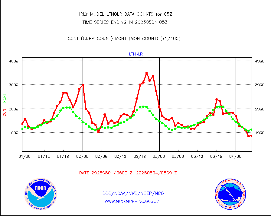
LLDN Long-rng lightning from Vaisala via NOAAPORT |
155943 |
156710 |
99.5 % |
0204.50-0205.49 |
||||||||||
NLDN Shrt-rng lightning from Vaisala via NOAAPORT |
4077 |
5581 |
73.1 % |
0204.50-0205.49 |
||||||||||
Moored buoys (decoded from BUFR) |
964 |
936 |
103.0 % |
0204.50-0205.50 |
||||||||||
Aura Microwave Limb Sounder (MLS) ozone data |
0 |
0 |
n/a |
0203.00-0203.99 |
||||||||||
Mesonet/MADIS UrbaNet |
3591 |
3539 |
101.5 % |
0204.50-0205.49 |
||||||||||
NEXRAD Vel Azm Dsp(VAD) winds via Level 2 decoder |
577 |
571 |
101.1 % |
0204.50-0205.49 |
||||||||||
OMPS Limb Profiler ozone data (NPP) |
116 |
274 |
42.3 % |
0122.00-0122.99 |
||||||||||
OMPS nadir profile ozone (Version 8 BUFR) |
501 |
555 |
90.3 % |
0203.00-0203.99 |
||||||||||
OMPS total column ozone (Version 8 BUFR) |
403508 |
333391 |
121.0 % |
0203.00-0203.99 |
||||||||||
PIBAL (decoded from BUFR) |
0 |
0 |
n/a |
0204.51-0205.49 |
||||||||||
Manual PIREP aircraft data (dcded from AIREP fmt) |
14 |
14 |
100.0 % |
0204.50-0205.49 |
||||||||||
Profilr winds from PIBAL (PILOT,PILOT SHIP/MOBIL) |
0 |
0 |
n/a |
0204.50-0205.49 |
||||||||||
Rawinsonde - fixed land (decoded from BUFR) |
4 |
3 |
133.3 % |
0204.51-0205.49 |
||||||||||
Rawinsonde - mobile land (from TEMP/PILOT MOBIL) |
0 |
0 |
n/a |
0204.50-0205.49 |
||||||||||
Rawinsonde - mobile land (decoded from BUFR) |
0 |
0 |
n/a |
0204.51-0205.49 |
||||||||||
Rawinsonde - ship (from TEMP SHIP, PILOT SHIP) |
0 |
0 |
n/a |
0204.50-0205.49 |
||||||||||
Rawinsonde - ship (decoded from BUFR) |
0 |
0 |
n/a |
0204.51-0205.49 |
||||||||||
Flight level reconnaissance aircraft data |
0 |
0 |
n/a |
0204.50-0205.49 |
||||||||||
Megha-Tropiques SAPHIR L1A2 brightness temps |
0 |
0 |
n/a |
0202.50-0203.49 |
||||||||||
METEOSAT-10 2nd Gen SEVIRI All Sky Radiance(proc) |
75512 |
75482 |
100.0 % |
0204.50-0205.49 |
||||||||||
Ship - manual and automatic, restricted |
17 |
15 |
113.3 % |
0204.50-0205.49 |
||||||||||
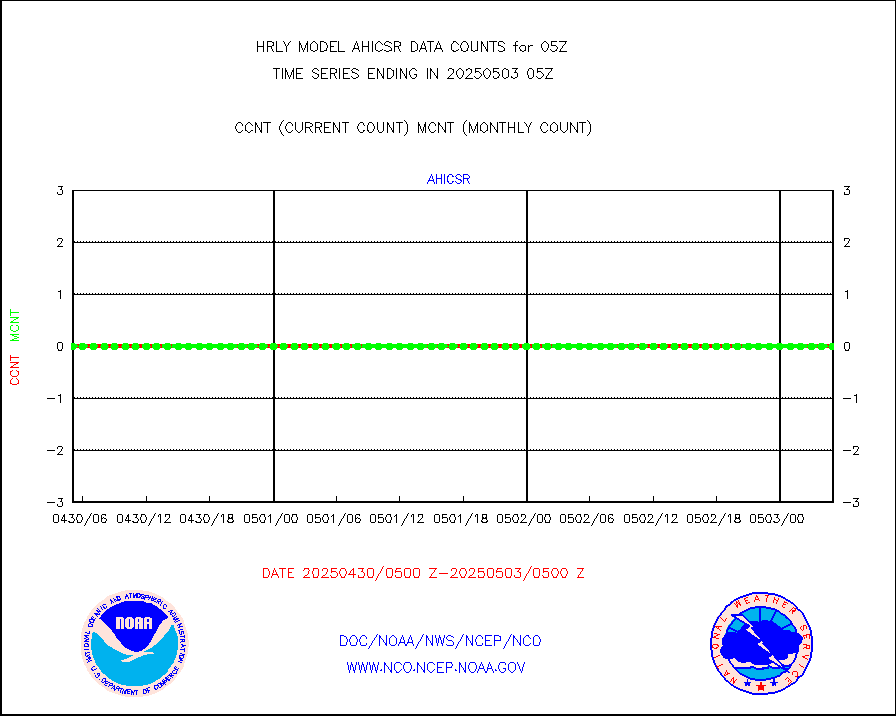
DMSP SSM/IS 1C radiance data (Unified Pre-Proc.) |
133920 |
117238 |
114.2 % |
0203.50-0204.49 |
||||||||||
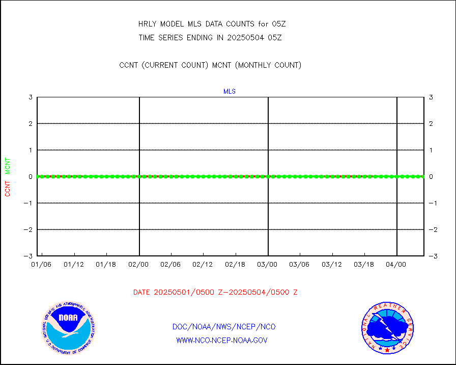
NPP/NOAA-20 VIIRS SST - CLEAR & OVER WATER |
4418298 |
1721307 |
256.7 % |
0204.50-0205.49 |
||||||||||
NPP/NOAA-20 VIIRS SST - PROBABLY CLR & OVER WATER |
1082289 |
371548 |
291.3 % |
0204.50-0205.49 |
||||||||||
Synoptic - mobile manual and automatic |
750 |
677 |
110.8 % |
0204.50-0205.49 |
||||||||||
Synoptic - mobile manual & auto (decoded fr BUFR) |
1 |
1 |
100.0 % |
0204.50-0205.49 |
||||||||||
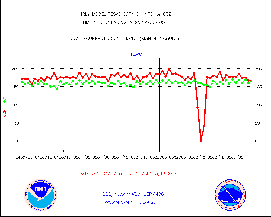
CTD probe, Argo prflng float, mooring (TESAC fmt) |
235 |
216 |
108.8 % |
0204.50-0205.49 |
||||||||||
TAMDAR aircft data-all types(from Panasonic,BUFR) |
52 |
49 |
106.1 % |
0204.50-0205.49 |
||||||||||
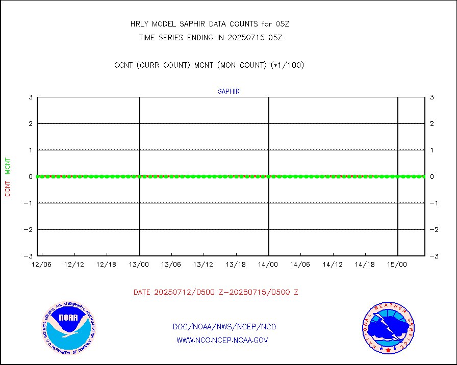
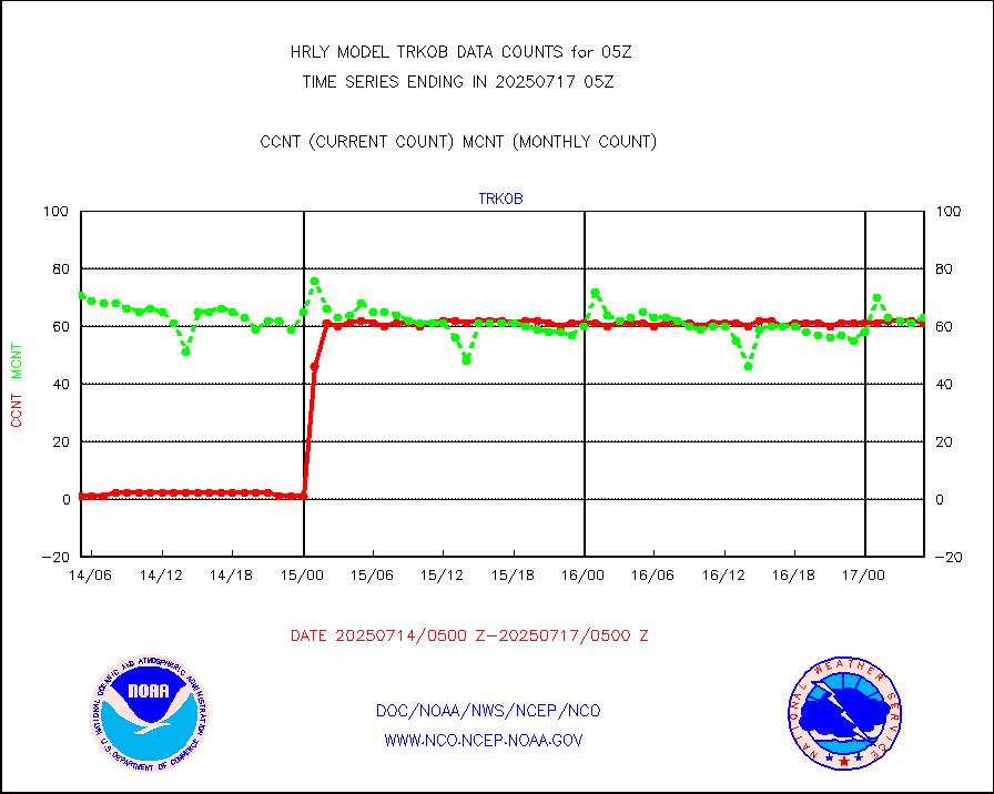
ThermoSalinoGraph (TSG) TRACKOB format) |
91 |
99 |
91.9 % |
0203.50-0204.49 |
||||||||||
INSAT/KALPANA India visible derived cloud motion |
0 |
0 |
n/a |
0202.50-0203.49 |
||||||||||
MTSAT/JMA visible derived cloud motion |
10920 |
10673 |
102.3 % |
0202.50-0203.49 |
||||||||||
GOES-16&up/NESDIS visible derived cloud motion |
56358 |
46531 |
121.1 % |
0204.00-0204.99 |
||||||||||
METEOSAT/EUMETSAT visible drv cld motion NBseq |
15541 |
17423 |
89.2 % |
0203.50-0204.49 |
||||||||||


