| Suspect Data Shortages in Critical Types - Monitor | ||||||||||||||
|---|---|---|---|---|---|---|---|---|---|---|---|---|---|---|
| Type | Description | Hourly Count | Monthly Average | Percent (%) of Monthly Mean | UTC Time Window | |||||||||
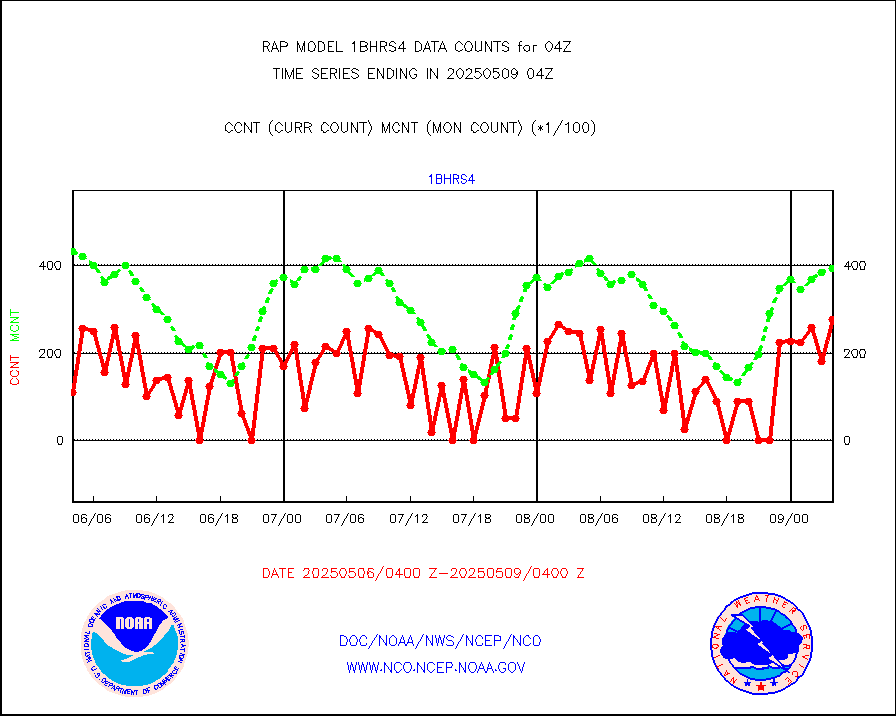
NOAA 18-19 & METOP 1-2 HIRS-4 NCEP-proc. br.temps |
0 |
10372 |
0.0 % |
0201.00-0206.99 |
||||||||||
| Shortage in Data Type of Opportunity - Monitor | ||||||||||||||
|---|---|---|---|---|---|---|---|---|---|---|---|---|---|---|
| Type | Description | Hourly Count | Monthly Average | Percent (%) of Monthly Mean | UTC Time Window | |||||||||
NPP Adv. Tech. MW Sndr (ATMS) br. temps from RARS |
0 |
16044 |
0.0 % |
0202.00-0205.99 |
||||||||||
NOAA 15-19 & METOP 1-2 HIRS-3/4 pr btmps frm RARS |
0 |
8198 |
0.0 % |
0203.00-0205.00 |
||||||||||
Mesonet/MADIS NFIC Remote Automated Wx Stns(RAWS) |
0 |
1399 |
0.0 % |
0203.50-0204.50 |
||||||||||
| Critical Data with Normal Counts | ||||||||||||||
|---|---|---|---|---|---|---|---|---|---|---|---|---|---|---|
| Type | Description | Hourly Count | Monthly Average | Percent (%) of Monthly Mean | UTC Time Window | |||||||||
NOAA 15-19 & METOP 1-2 AMSU-A NCEP-proc. br.temps |
23133 |
25786 |
89.7 % |
0201.00-0206.99 |
||||||||||
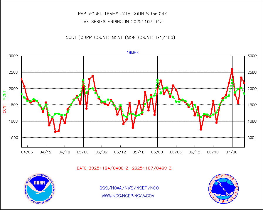
NOAA 18-19 & METOP 1-2 MHS NCEP-proces. br. temps |
206270 |
223158 |
92.4 % |
0201.00-0206.99 |
||||||||||
MDCRS ACARS acft data from ARINC(dcded from BUFR) |
107668 |
147678 |
72.9 % |
0200.75-0207.25 |
||||||||||
Canadian AMDAR aircraft data (decoded from BUFR) |
0 |
0 |
n/a |
0200.75-0207.25 |
||||||||||
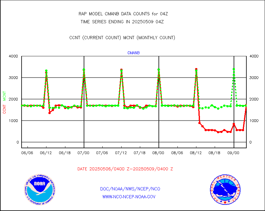
Surface Marine CMAN rpts decoded from BUFR format |
1725 |
1724 |
100.1 % |
0203.50-0204.50 |
||||||||||
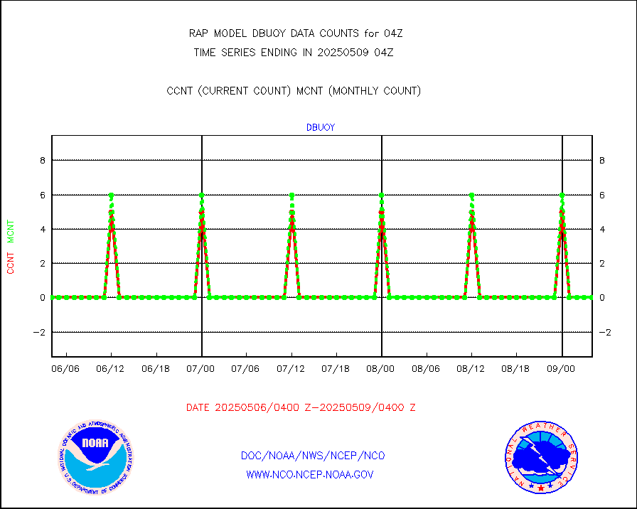
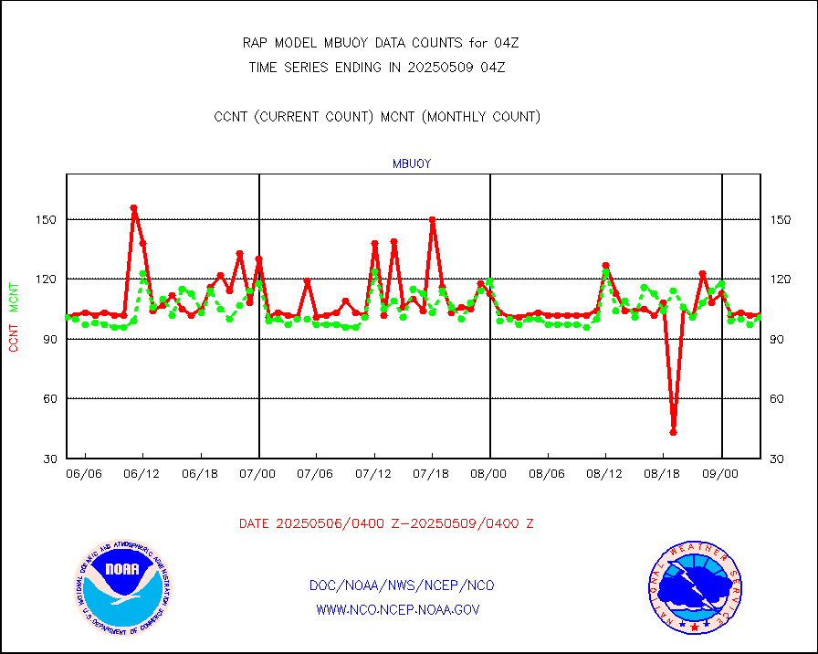
Buoys decoded from FM-18 fmt (moored or drifting) |
0 |
0 |
n/a |
0203.50-0204.50 |
||||||||||
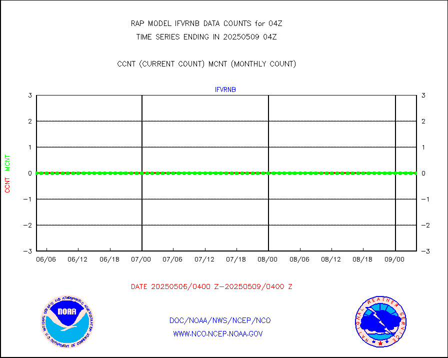
Grnd-based Gbl Navigation Sat System (GNSS) data |
717 |
2097 |
34.2 % |
0202.95-0203.05 |
||||||||||
MODIS (AQUA/TERRA) wvpr imager derived cld motion |
0 |
0 |
n/a |
0201.50-0206.50 |
||||||||||
MODIS (AQUA/TERRA) ir l-wave derived cloud motion |
0 |
0 |
n/a |
0201.50-0206.50 |
||||||||||
GOES/NASA(Langley) hi-res. (1x1 f-o-v) cloud data |
1874967 |
1783093 |
105.2 % |
0203.50-0204.50 |
||||||||||
Buoys decoded from FM-13 format (moored) |
114 |
117 |
97.4 % |
0203.50-0204.50 |
||||||||||
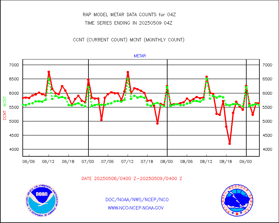
Aviation - METAR |
5651 |
5559 |
101.7 % |
0203.50-0204.50 |
||||||||||
NEXRAD Vel Azm Dsp(VAD) winds via radar coded msg |
0 |
0 |
n/a |
0203.00-0205.00 |
||||||||||
Multi-Agency Profiler (MAP) and SODAR winds |
104 |
97 |
107.2 % |
0202.50-0205.50 |
||||||||||
Rawinsonde - fixed land (from TEMP or PILOT) |
0 |
0 |
n/a |
0203.00-0205.00 |
||||||||||
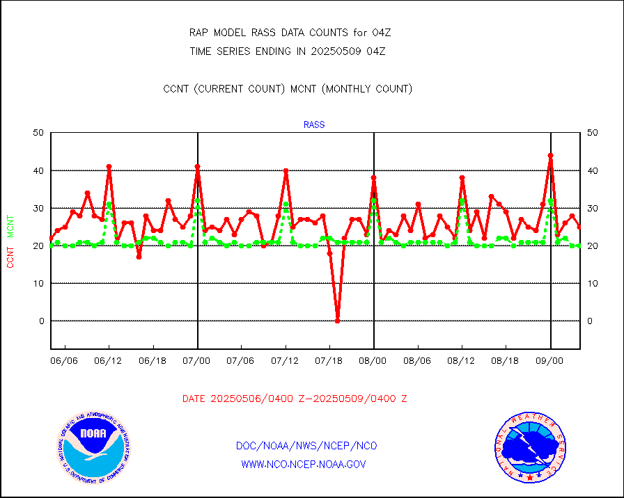
RASS temperatures (NOAA and Multi-Agency) |
27 |
21 |
128.6 % |
0203.50-0204.50 |
||||||||||
Ship - manual and automatic, restricted (BUFR) |
0 |
0 |
n/a |
0203.50-0204.50 |
||||||||||
Ship - manual and automatic, unrestricted |
102 |
107 |
95.3 % |
0203.50-0204.50 |
||||||||||
Ship - manual and automatic, unrestricted (BUFR) |
725 |
656 |
110.5 % |
0203.50-0204.50 |
||||||||||
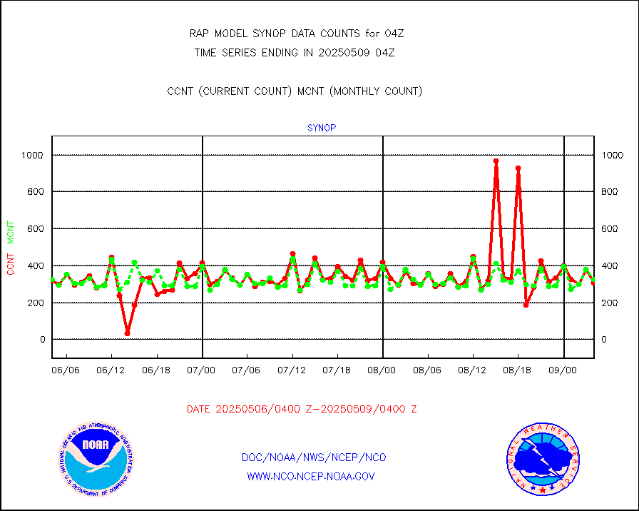
Synoptic - fixed manual and automatic |
246 |
288 |
85.4 % |
0203.50-0204.50 |
||||||||||
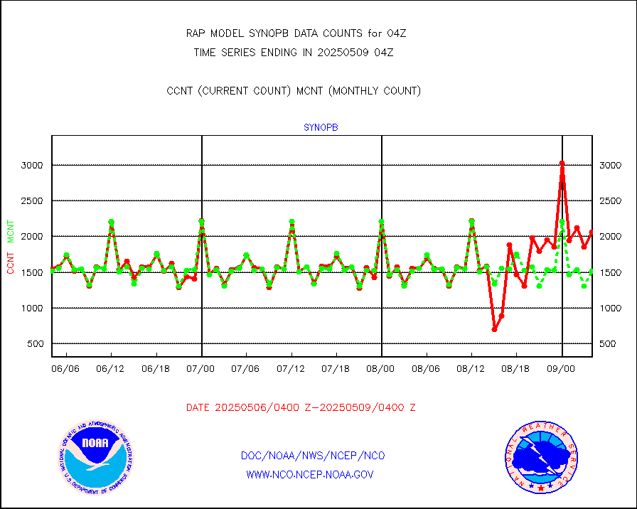
Synoptic - fixed manual & auto (decoded fr BUFR) |
2035 |
1999 |
101.8 % |
0203.50-0204.50 |
||||||||||
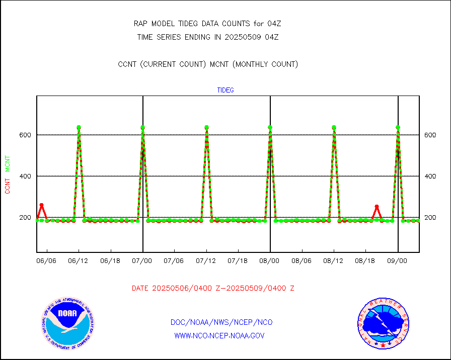
Tide gauge reports decoded from CREX format |
187 |
185 |
101.1 % |
0203.50-0204.50 |
||||||||||
| Data Types of Opportunity with Normal Counts | ||||||||||||||
|---|---|---|---|---|---|---|---|---|---|---|---|---|---|---|
| Type | Description | Hourly Count | Monthly Average | Percent (%) of Monthly Mean | UTC Time Window | |||||||||
GOES-16&up/NESDIS ir short-wv derived cld motion |
4926 |
5572 |
88.4 % |
0203.00-0203.99 |
||||||||||
MDCRS ACARS acft data (ARINC via AFWA)(AIREP fmt) |
0 |
0 |
n/a |
0200.75-0207.25 |
||||||||||
Manual AIREP aircraft data (dcded from AIREP fmt) |
2597 |
3155 |
82.3 % |
0200.75-0207.25 |
||||||||||
AQUA AIRS/AMSU-A/HSB brightness temps- every FOV |
0 |
0 |
n/a |
0201.00-0206.99 |
||||||||||
AMDAR aircraft data (decoded from AMDAR format) |
2733 |
2062 |
132.5 % |
0200.75-0207.25 |
||||||||||
AMDAR aircraft data (decoded from BUFR) |
10599 |
11942 |
88.8 % |
0200.75-0207.25 |
||||||||||
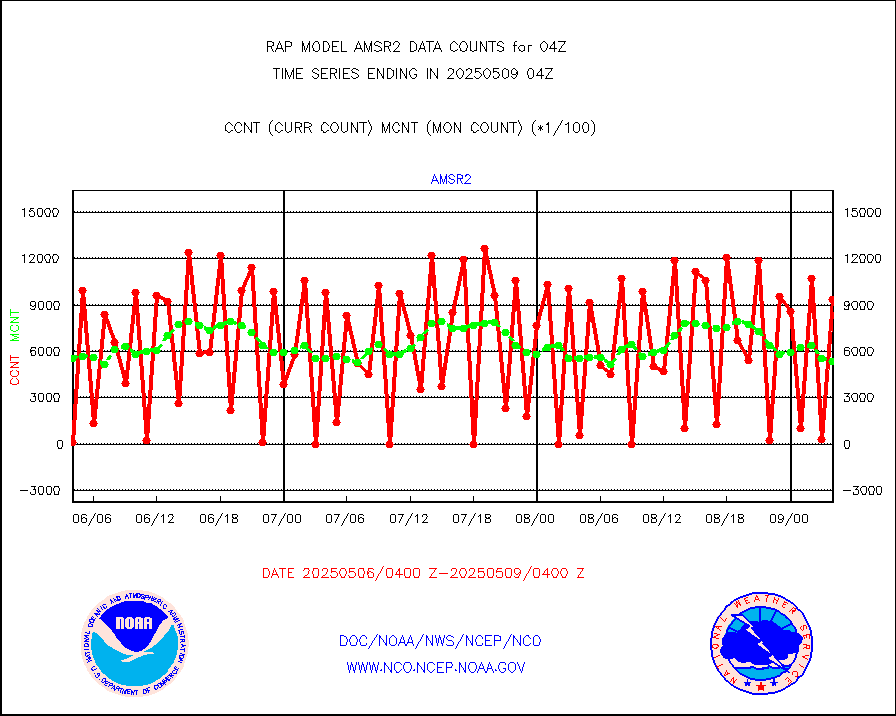
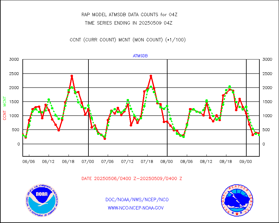
GCOM-W AMSR2 1B brightness temperatures |
0 |
563343 |
0.0 % |
0201.00-0201.99 |
||||||||||
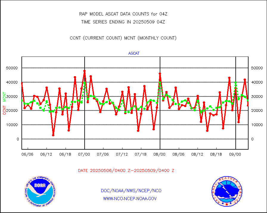
METOP 1-2 ASCAT products |
20159 |
27433 |
73.5 % |
0202.00-0206.00 |
||||||||||
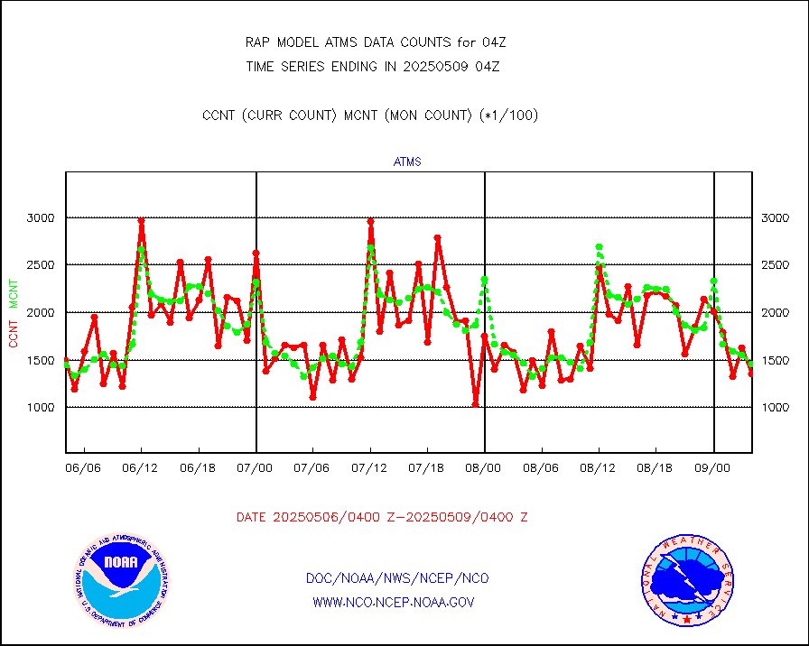
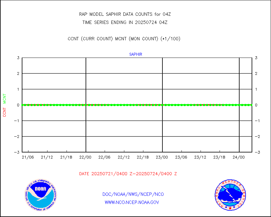
NPP/NOAA-20 ATMS brightness temperatures |
156019 |
142455 |
109.5 % |
0202.00-0205.99 |
||||||||||
NPP/NOAA-20 ATMS bright. temps-direct b-cast SSEC |
28082 |
31758 |
88.4 % |
0202.00-0205.99 |
||||||||||
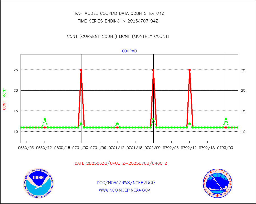
Coop/MADIS NEPP & HCN-Modernization NOAA COOP Obs |
11 |
11 |
100.0 % |
0203.50-0204.50 |
||||||||||
NPP/NOAA-20 CrIS full spctrl radn (431 ch subset) |
107387 |
89651 |
119.8 % |
0202.00-0205.99 |
||||||||||
NPP/NOAA-20 CrIS full spctrl radn dir brdcst SSEC |
10688 |
19983 |
53.5 % |
0202.00-0205.99 |
||||||||||
Coast Guard |
5 |
5 |
100.0 % |
0203.50-0204.50 |
||||||||||
Drifting buoys (decoded from BUFR) |
542 |
527 |
102.8 % |
0203.50-0204.50 |
||||||||||
Dropwinsonde (from TEMP DROP) |
0 |
0 |
n/a |
0203.00-0205.00 |
||||||||||
Dropwinsonde (decoded from BUFR) |
1 |
0 |
n/a |
0203.00-0205.00 |
||||||||||
E-AMDAR (European AMDAR acft decoded from BUFR) |
3312 |
3163 |
104.7 % |
0200.75-0207.25 |
||||||||||
NOAA 15-19 & METOP 1-2 AMSU-A proc btmps frm RARS |
9640 |
12944 |
74.5 % |
0203.00-0205.00 |
||||||||||
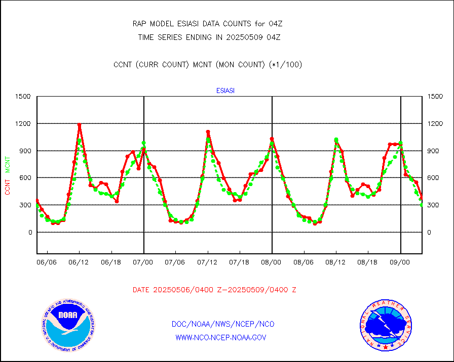
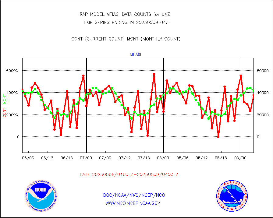
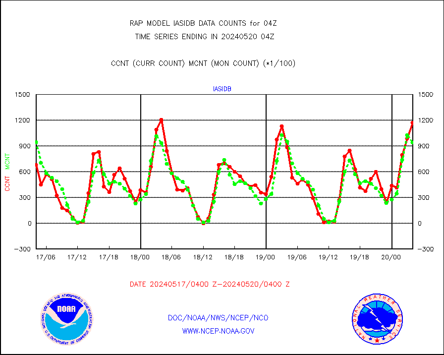
METOP 1-2 IASI 1C radiance data vbl chn from RARS |
47 |
2186 |
2.2 % |
0202.00-0205.99 |
||||||||||
NOAA 18-19 & METOP 1-2 MHS proc. btemps from RARS |
64177 |
132475 |
48.4 % |
0203.00-0205.00 |
||||||||||
GPM GMI Level 1C-R brightness temperatures |
388159 |
453836 |
85.5 % |
0201.00-0206.99 |
||||||||||
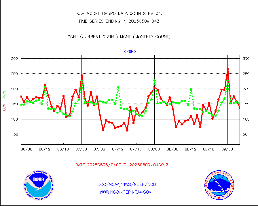
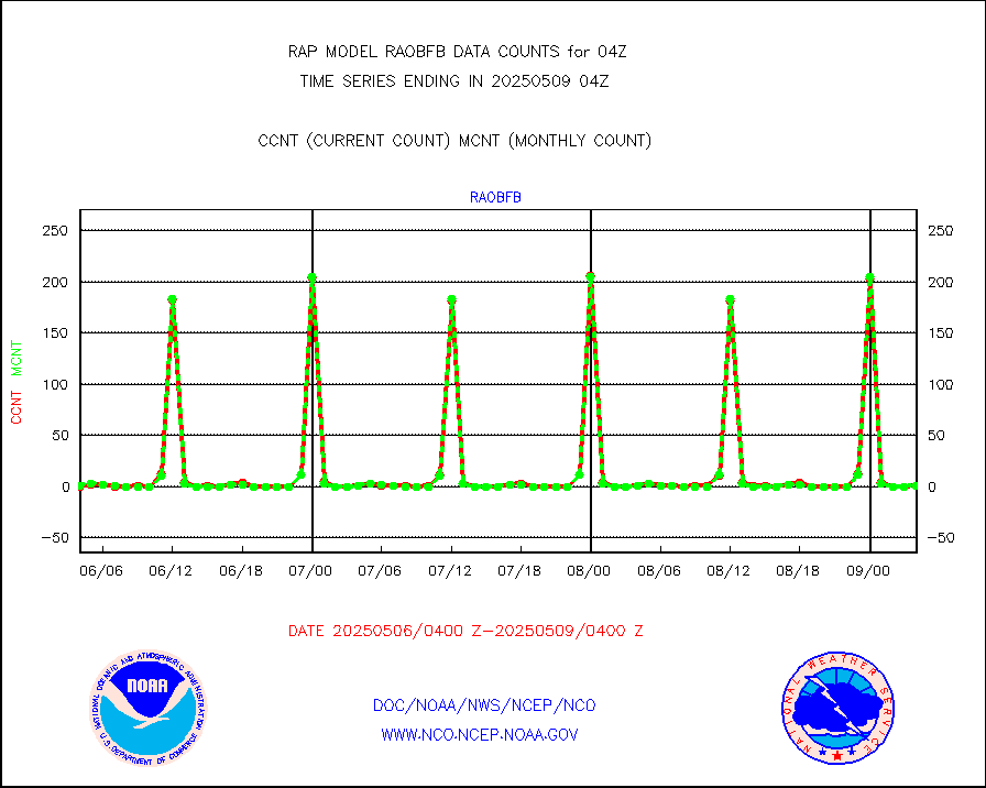
GPS radio occultation data |
155 |
180 |
86.1 % |
0202.00-0205.99 |
||||||||||
GOES-16/17 All Sky Radiances (proc.) |
812097 |
812090 |
100.0 % |
0202.00-0205.99 |
||||||||||
GOES-16/17 Clear Sky Radiances (proc.) |
377908 |
376510 |
100.4 % |
0202.00-0205.99 |
||||||||||
MTSAT/JMA water vapor imager derived cloud motion |
2682 |
2903 |
92.4 % |
0201.50-0206.50 |
||||||||||
GOES-16&up/NESDIS wv imgr/deep-lyr derivd cld mtn |
9442 |
7536 |
125.3 % |
0203.00-0203.99 |
||||||||||
METEOSAT/EUMETSAT wvpr imgr drv cld motion NBseq |
5045 |
5226 |
96.5 % |
0202.50-0205.49 |
||||||||||
GOES-16&up/NESDIS wv imgr/cld-top derived cld mtn |
15621 |
15327 |
101.9 % |
0203.00-0203.99 |
||||||||||
METOP 1-2 IASI 1C radiances-direct broadcast SSEC |
100329 |
116787 |
85.9 % |
0202.00-0205.99 |
||||||||||
METEOSAT/EUMETSAT ir lg-wave drv cld motion NBseq |
3100 |
3103 |
99.9 % |
0202.50-0205.49 |
||||||||||
VIIRS (NPP/NOAA-20) ir lg-wv drv cloud motion(NB) |
0 |
0 |
n/a |
0201.50-0206.50 |
||||||||||
AVHRR (NOAA/METOP) ir lg-wave derived cld motion |
0 |
0 |
n/a |
0201.50-0206.50 |
||||||||||
AVHRR (METOP) ir lg-wave derived cld motion |
0 |
0 |
n/a |
0202.50-0205.49 |
||||||||||
MTSAT/JMA infrared long-wave derived cloud motion |
2339 |
2359 |
99.2 % |
0201.50-0206.50 |
||||||||||
GOES-16&up/NESDIS ir long-wave derived cld motion |
29609 |
30332 |
97.6 % |
0203.00-0203.99 |
||||||||||
Korean AMDAR aircraft data (decoded from BUFR) |
259 |
265 |
97.7 % |
0200.75-0207.25 |
||||||||||
Land-based CMAN stations decoded from CMAN format |
55 |
46 |
119.6 % |
0203.50-0204.50 |
||||||||||
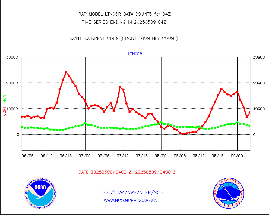
LLDN Long-rng lightning from Vaisala via NOAAPORT |
158933 |
163885 |
97.0 % |
0203.00-0204.50 |
||||||||||
NLDN Shrt-rng lightning from Vaisala via NOAAPORT |
5890 |
9191 |
64.1 % |
0203.00-0204.50 |
||||||||||
Moored buoys (decoded from BUFR) |
689 |
658 |
104.7 % |
0203.50-0204.50 |
||||||||||
Mesonet/MADIS Colorado E-470 (Interstate 470) |
24 |
23 |
104.3 % |
0203.50-0204.50 |
||||||||||
Mesonet/MADIS Alaska Department of Transportation |
116 |
68 |
170.6 % |
0203.50-0204.50 |
||||||||||
Mesonet/MADIS U.S. Army Aberdeen Proving Grounds |
0 |
0 |
n/a |
0203.50-0204.50 |
||||||||||
Mesonet/MADIS Citizen Weather Observers Program |
45593 |
53913 |
84.6 % |
0203.50-0204.50 |
||||||||||
Mesonet/MADIS AWS Convergence Technologies, Inc. |
16092 |
19691 |
81.7 % |
0203.50-0204.50 |
||||||||||
Mesonet/MADIS "Anything Weather" |
0 |
0 |
n/a |
0203.50-0204.50 |
||||||||||
Mesonet/MADIS Colorado Dept. of Transportation |
0 |
0 |
n/a |
0203.50-0204.50 |
||||||||||
Mesonet/MADIS DC Net |
0 |
0 |
n/a |
0203.50-0204.50 |
||||||||||
Mesonet/MADIS Denver Urban Drainage & Flood Cntrl |
0 |
0 |
n/a |
0203.50-0204.50 |
||||||||||
Mesonet/MADIS Florida (FAWN & USF) |
3 |
3 |
100.0 % |
0203.50-0204.50 |
||||||||||
Mesonet/MADIS Florida Dept. of Transportation |
0 |
0 |
n/a |
0203.50-0204.50 |
||||||||||
Mesonet/MADIS Georgia Dept. of Transportation |
0 |
0 |
n/a |
0203.50-0204.50 |
||||||||||
Mesonet/MADIS NWS Hydromet Auto Data System(HADS) |
4253 |
5045 |
84.3 % |
0203.50-0204.50 |
||||||||||
Mesonet/MADIS Iowa Environmental |
132 |
162 |
81.5 % |
0203.50-0204.50 |
||||||||||
Mesonet/MADIS Indiana Dept. of Transportation |
0 |
0 |
n/a |
0203.50-0204.50 |
||||||||||
Mesonet/MADIS Iowa Department of Transportation |
0 |
0 |
n/a |
0203.50-0204.50 |
||||||||||
Mesonet/MADIS Kansas Department of Transportation |
184 |
311 |
59.2 % |
0203.50-0204.50 |
||||||||||
Mesonet/MADIS Oklahoma Mesonet |
422 |
567 |
74.4 % |
0203.50-0204.50 |
||||||||||
Mesonet/MADIS Louisiana State/Jackson State Univ. |
0 |
0 |
n/a |
0203.50-0204.50 |
||||||||||
Mesonet/MADIS Missouri Commercial Agricult Wx Net |
244 |
289 |
84.4 % |
0203.50-0204.50 |
||||||||||
Mesonet/MADIS Minnesota Dept. of Transportation |
0 |
0 |
n/a |
0203.50-0204.50 |
||||||||||
Mesonet/MADIS NOS-Phys Oceanographic Realtime Sys |
255 |
258 |
98.8 % |
0203.50-0204.50 |
||||||||||
Mesonet/MADIS many providers, not separated out |
25984 |
37697 |
68.9 % |
0203.50-0204.50 |
||||||||||
Mesonet/MADIS UrbaNet |
2889 |
3094 |
93.4 % |
0203.50-0204.50 |
||||||||||
Mesonet/MADIS Virginia Dept. of Transportation |
0 |
0 |
n/a |
0203.50-0204.50 |
||||||||||
Mesonet/MADIS "Weather for You" |
0 |
0 |
n/a |
0203.50-0204.50 |
||||||||||
Mesonet/MADIS Wisconsin Dept. of Transportation |
0 |
0 |
n/a |
0203.50-0204.50 |
||||||||||
Mesonet/MADIS MesoWest (many subproviders) |
23535 |
35026 |
67.2 % |
0203.50-0204.50 |
||||||||||
Mesonet/MADIS West Texas |
4628 |
5279 |
87.7 % |
0203.50-0204.50 |
||||||||||
METOP 1-2 IASI 1C radiance data (varbl. channels) |
43443 |
42861 |
101.4 % |
0202.00-0205.99 |
||||||||||
NEXRAD Vel Azm Dsp(VAD) winds via Level 2 decoder |
1151 |
1066 |
108.0 % |
0203.00-0205.00 |
||||||||||
NOAA 16-19 Solar Backscatter UV-2 rad frm V8 BUFR |
0 |
0 |
n/a |
0202.00-0204.99 |
||||||||||
PIBAL (from PILOT, PILOT SHIP, PILOT MOBIL) |
0 |
0 |
n/a |
0203.00-0205.00 |
||||||||||
PIBAL (decoded from BUFR) |
0 |
0 |
n/a |
0203.00-0205.00 |
||||||||||
Manual PIREP aircraft data (dcded from AIREP fmt) |
150 |
173 |
86.7 % |
0200.75-0207.25 |
||||||||||
Profilr winds from PIBAL (PILOT,PILOT SHIP/MOBIL) |
0 |
0 |
n/a |
0202.50-0205.50 |
||||||||||
Rawinsonde - fixed land (decoded from BUFR) |
1 |
1 |
100.0 % |
0203.00-0205.00 |
||||||||||
Rawinsonde - mobile land (from TEMP/PILOT MOBIL) |
0 |
0 |
n/a |
0203.00-0205.00 |
||||||||||
Rawinsonde - mobile land (decoded from BUFR) |
0 |
0 |
n/a |
0203.00-0205.00 |
||||||||||
Rawinsonde - ship (from TEMP SHIP, PILOT SHIP) |
0 |
0 |
n/a |
0203.00-0205.00 |
||||||||||
Rawinsonde - ship (decoded from BUFR) |
0 |
0 |
n/a |
0203.00-0205.00 |
||||||||||
NEXRAD radial wind (Level 2 - GTS) |
1724437 |
1504395 |
114.6 % |
0203.50-0204.49 |
||||||||||
Flight level reconnaissance aircraft data |
0 |
0 |
n/a |
0203.00-0205.00 |
||||||||||
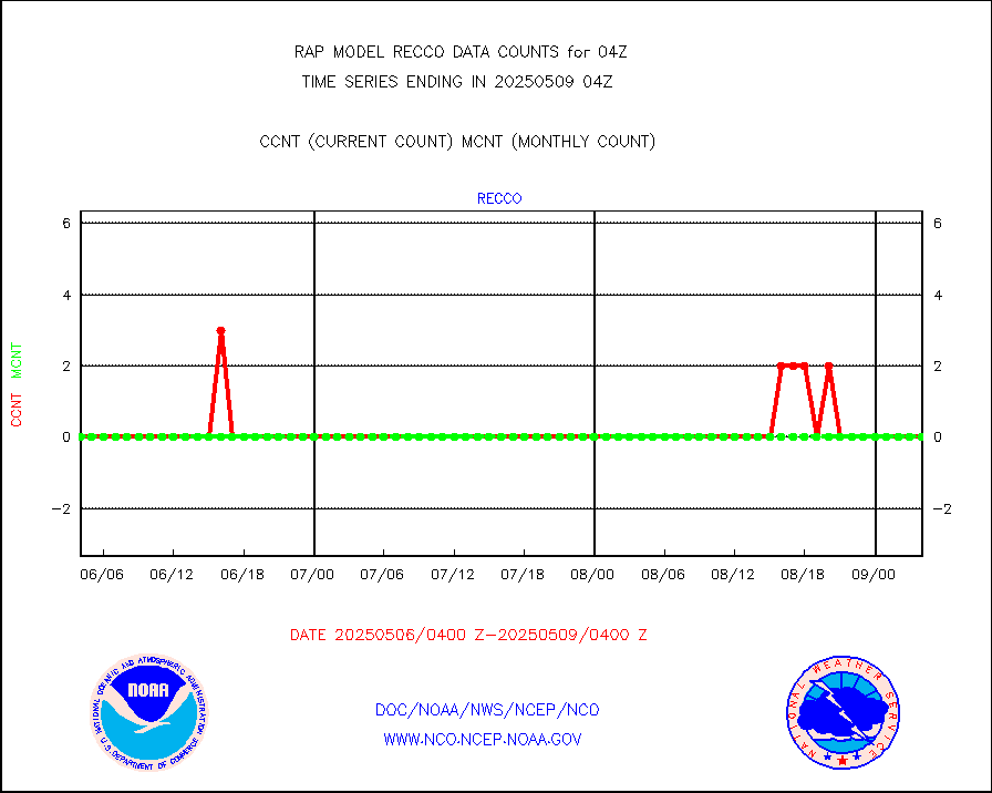
Surface Marine Saildrone (decoded from BUFR) |
2 |
2 |
100.0 % |
0202.00-0205.99 |
||||||||||
Megha-Tropiques SAPHIR L1A2 brightness temps |
0 |
0 |
n/a |
0201.00-0206.99 |
||||||||||
METEOSAT-10 2nd Gen SEVIRI All Sky Radiance(proc) |
9512 |
9510 |
100.0 % |
0202.00-0205.99 |
||||||||||
METEOSAT-10 2nd Gen SEVIRI Clr Sky Radiance(proc) |
0 |
0 |
n/a |
0202.00-0205.99 |
||||||||||
Ship - manual and automatic, restricted |
5 |
13 |
38.5 % |
0203.50-0204.50 |
||||||||||
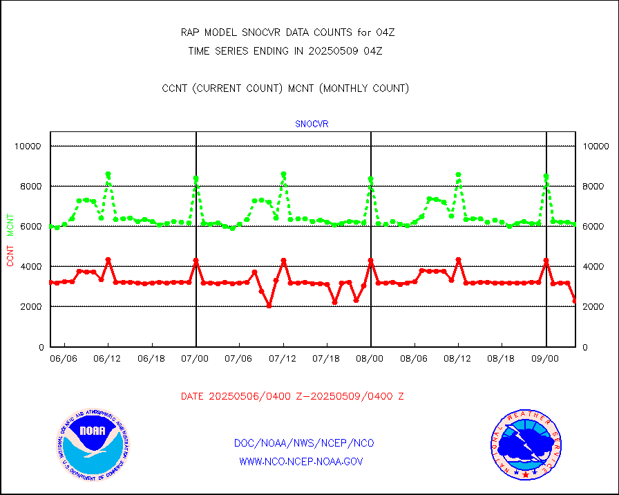
NOW COVER, DEPTH/DENSITY AND WATER EQUIVALENT |
3184 |
6032 |
52.8 % |
0202.00-0206.00 |
||||||||||
DMSP SSM/IS 1C radiance data (Unified Pre-Proc.) |
45091 |
52775 |
85.4 % |
0202.00-0205.99 |
||||||||||
Sub-surface float and glider profile (BUFR) |
4 |
4 |
100.0 % |
0202.00-0205.99 |
||||||||||
Synoptic - restricted (WMO Res 40) manual & auto. |
0 |
0 |
n/a |
0203.50-0204.50 |
||||||||||
Synoptic - restricted (WMO Res 40)(decoded BUFR) |
290 |
362 |
80.1 % |
0203.50-0204.50 |
||||||||||
Synoptic - mobile manual & auto (decoded fr BUFR) |
0 |
0 |
n/a |
0203.50-0204.50 |
||||||||||
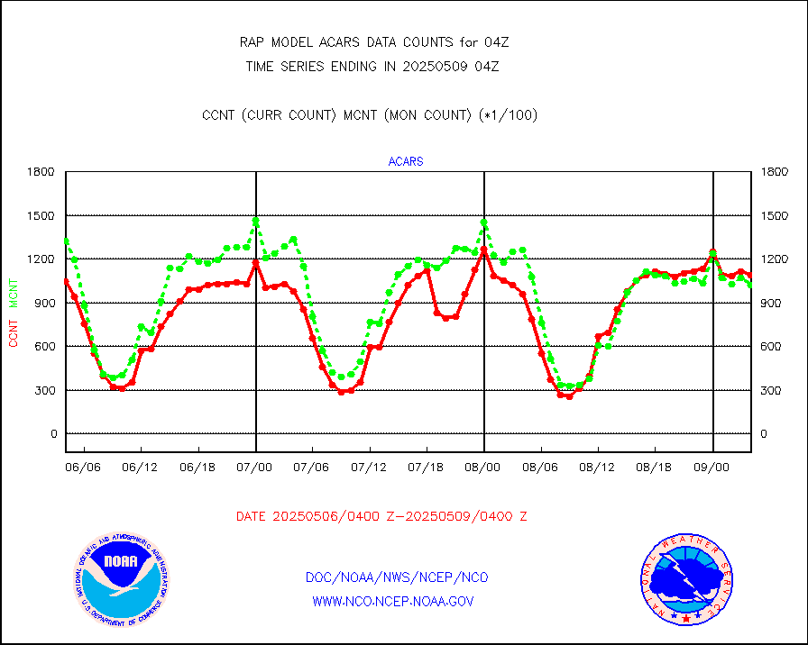
TAMDAR aircft data-all types(from Panasonic,BUFR) |
140 |
149 |
94.0 % |
0200.75-0207.25 |
||||||||||
MTSAT/JMA visible derived cloud motion |
1657 |
1466 |
113.0 % |
0201.50-0206.50 |
||||||||||
GOES-16&up/NESDIS visible derived cloud motion |
70461 |
65123 |
108.2 % |
0203.00-0203.99 |
||||||||||
METEOSAT/EUMETSAT visible drv cld motion NBseq |
108 |
104 |
103.8 % |
0202.50-0205.49 |
||||||||||


