| Suspect Data Shortages in Critical Types - Monitor | ||||||||||||||
|---|---|---|---|---|---|---|---|---|---|---|---|---|---|---|
| Type | Description | Hourly Count | Monthly Average | Percent (%) of Monthly Mean | ||||||||||
NOAA 18-19 & METOP 1-2 HIRS-4 NCEP-proc. br.temps |
0 |
89947 |
0.0 % |
|||||||||||
NOAA 15-19 & METOP 1-2 HIRS-3/4 pr btmps frm RARS |
0 |
190598 |
0.0 % |
|||||||||||
| Shortage in Data Type of Opportunity - Monitor | ||||||||||||||
|---|---|---|---|---|---|---|---|---|---|---|---|---|---|---|
| Type | Description | Hourly Count | Monthly Average | Percent (%) of Monthly Mean | ||||||||||
P.M.(N18-19) AVHRR GAC NCEP-proc clr & sea btemps |
0 |
2469631 |
0.0 % |
|||||||||||
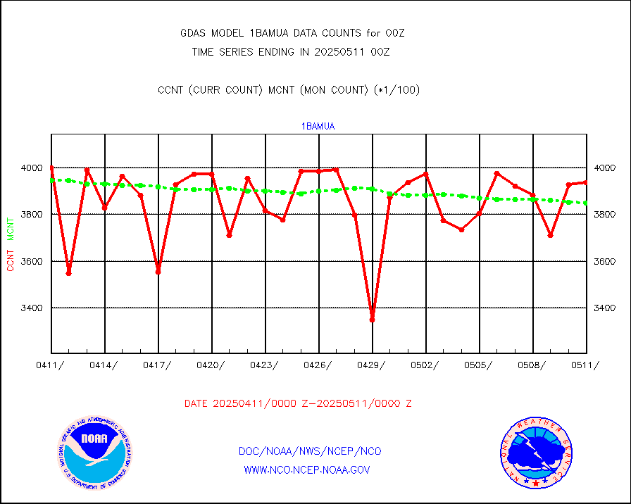
NPP Adv. Tech. MW Sndr (ATMS) br. temps from RARS |
12672 |
38157 |
33.2 % |
|||||||||||
INDIA SATWIND, INSAT WV channel |
0 |
28084 |
0.0 % |
|||||||||||
High Density OBs from reconnaissance acft data |
0 |
123 |
0.0 % |
|||||||||||
INDIA SATWIND, INSAT IR channel |
0 |
40716 |
0.0 % |
|||||||||||
INDIA SATWIND, INSAT VIS channel |
0 |
18 |
0.0 % |
|||||||||||
| Critical Data with Normal Counts | ||||||||||||||
|---|---|---|---|---|---|---|---|---|---|---|---|---|---|---|
| Type | Description | Hourly Count | Monthly Average | Percent (%) of Monthly Mean | ||||||||||
NOAA 15-19 & METOP 1-2 AMSU-A NCEP-proc. br.temps |
162055 |
220606 |
73.5 % |
|||||||||||
NOAA 18-19 & METOP 1-2 MHS NCEP-proces. br. temps |
1442643 |
1765945 |
81.7 % |
|||||||||||
MDCRS ACARS acft data from ARINC(dcded from BUFR) |
204635 |
209538 |
97.7 % |
|||||||||||
Himawari Clear Sky Radiance |
291875 |
296408 |
98.5 % |
|||||||||||
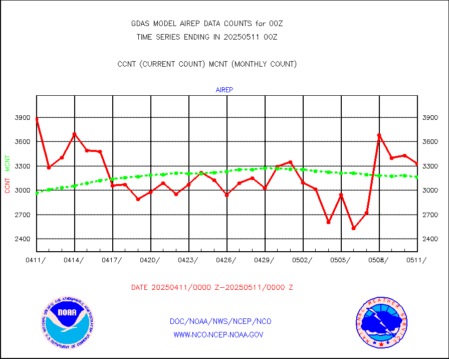
Manual AIREP aircraft data (dcded from AIREP fmt) |
2655 |
3248 |
81.7 % |
|||||||||||
AQUA AIRS/AMSU-A/HSB brightness temps- every FOV |
0 |
0 |
n/a |
|||||||||||
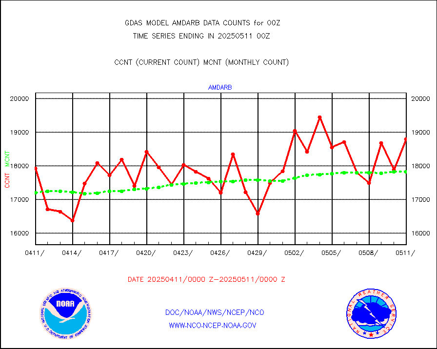
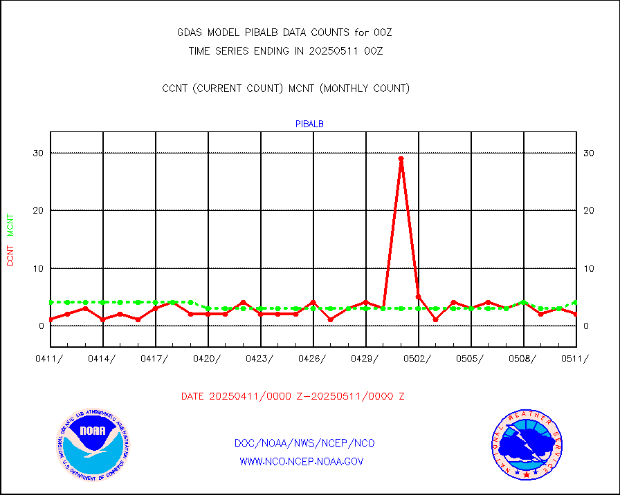
AMDAR aircraft data (decoded from AMDAR format) |
4909 |
4732 |
103.7 % |
|||||||||||
AMDAR aircraft data (decoded from BUFR) |
15928 |
17869 |
89.1 % |
|||||||||||
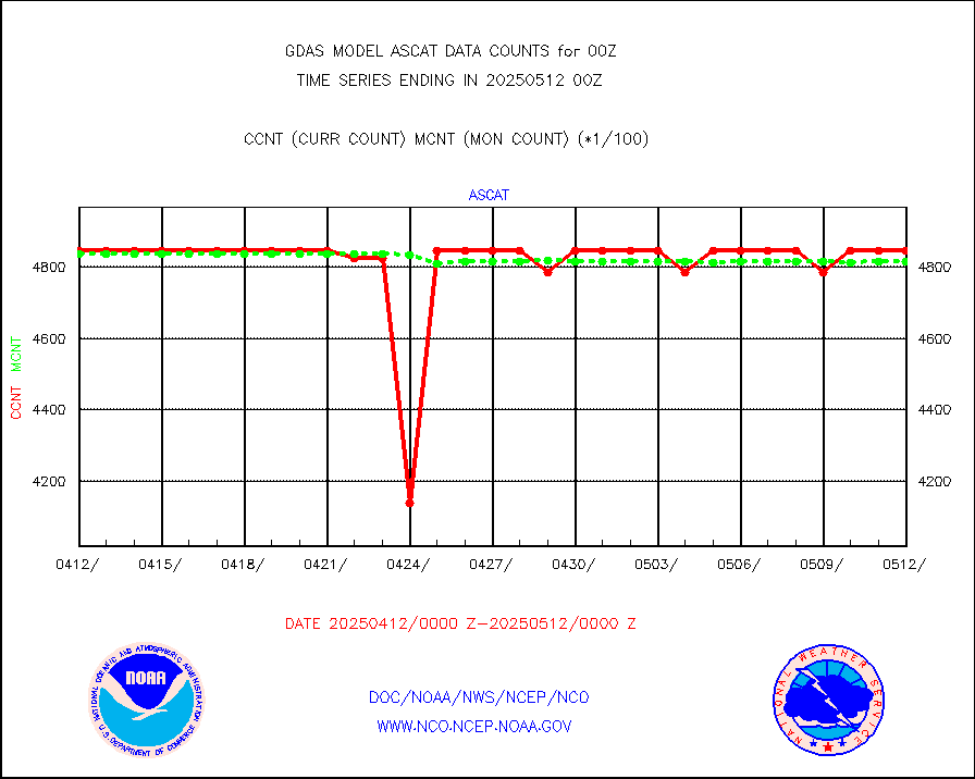
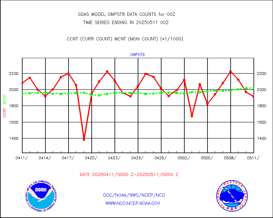
METOP 1-2 ASCAT products |
484596 |
484254 |
100.1 % |
|||||||||||
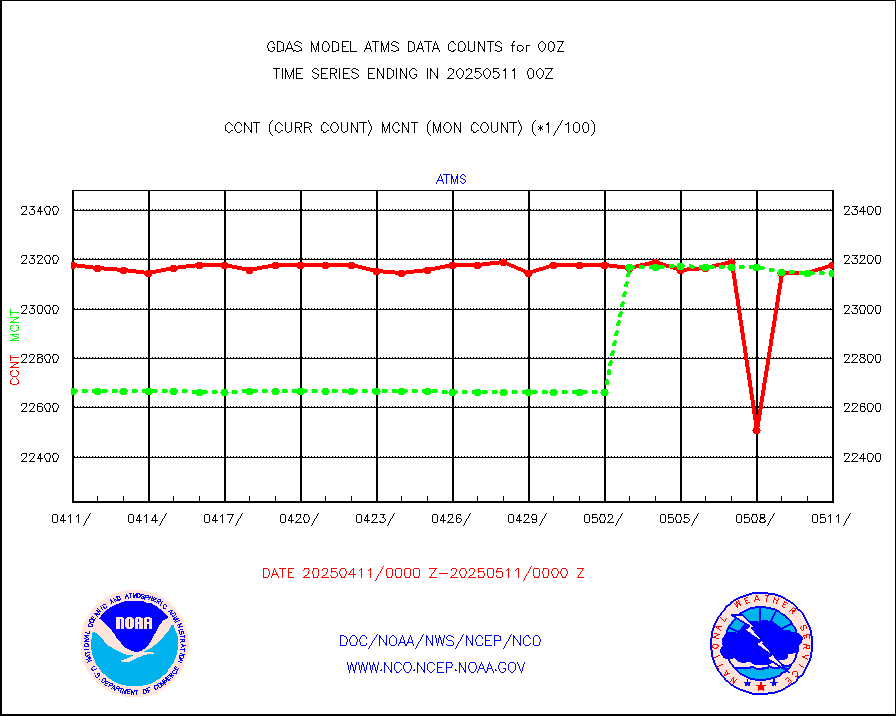
NPP/NOAA-20 ATMS brightness temperatures |
2318970 |
2316894 |
100.1 % |
|||||||||||
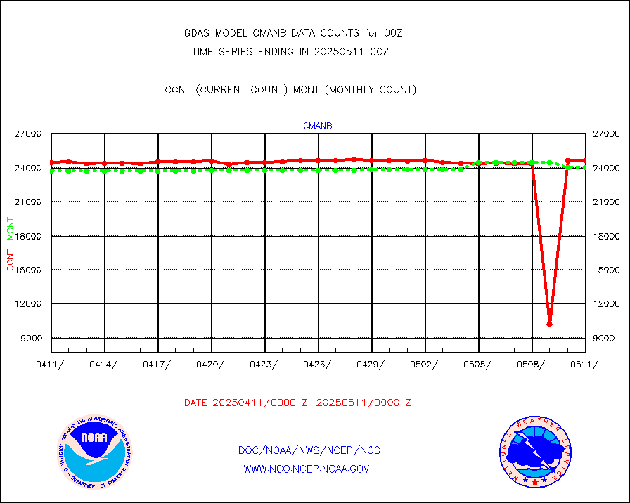
Surface Marine CMAN rpts decoded from BUFR format |
24862 |
24771 |
100.4 % |
|||||||||||
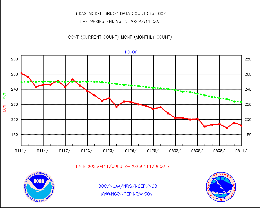
Buoys decoded from FM-18 fmt (moored or drifting) |
105 |
132 |
79.5 % |
|||||||||||
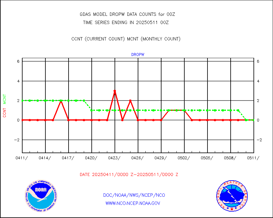
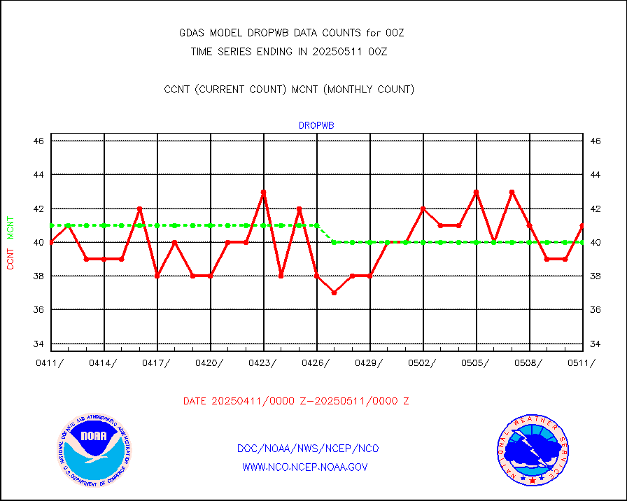
Dropwinsonde (from TEMP DROP) |
0 |
0 |
n/a |
|||||||||||
E-AMDAR (European AMDAR acft decoded from BUFR) |
9613 |
9710 |
99.0 % |
|||||||||||
NOAA 15-19 & METOP 1-2 AMSU-A proc btmps frm RARS |
151520 |
196610 |
77.1 % |
|||||||||||
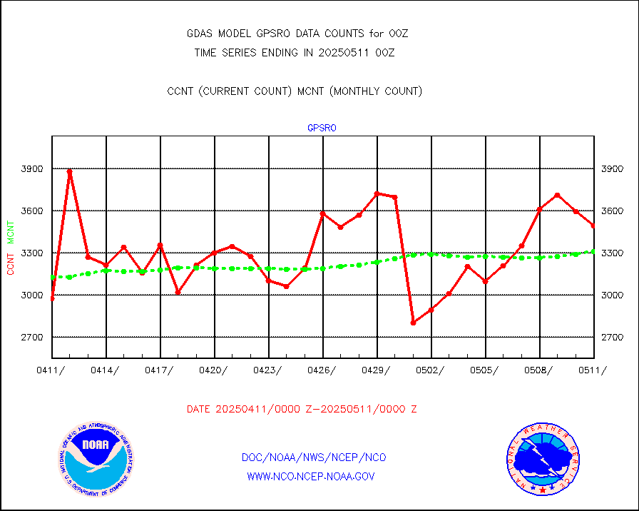
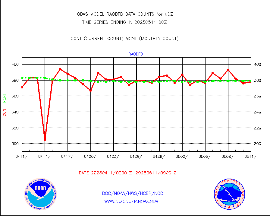
GPS radio occultation data |
3538 |
3465 |
102.1 % |
|||||||||||
GOES-16/17 All Sky Radiances (proc.) |
6488568 |
6477494 |
100.2 % |
|||||||||||
GOES-16/17 Clear Sky Radiances (proc.) |
3265205 |
3342905 |
97.7 % |
|||||||||||
MTSAT/JMA water vapor imager derived cloud motion |
64494 |
58764 |
109.8 % |
|||||||||||
MODIS (AQUA/TERRA) wvpr imager derived cld motion |
0 |
0 |
n/a |
|||||||||||
GOES-16&up/NESDIS wv imgr/cld-top derived cld mtn |
165267 |
178840 |
92.4 % |
|||||||||||
METEOSAT/EUMETSAT ir lg-wave drv cld motion NBseq |
130942 |
125376 |
104.4 % |
|||||||||||
MTSAT/JMA infrared long-wave derived cloud motion |
50400 |
49050 |
102.8 % |
|||||||||||
MODIS (AQUA/TERRA) ir l-wave derived cloud motion |
0 |
0 |
n/a |
|||||||||||
GOES-16&up/NESDIS ir long-wave derived cld motion |
485778 |
496205 |
97.9 % |
|||||||||||
Land-based CMAN stations decoded from CMAN format |
516 |
523 |
98.7 % |
|||||||||||
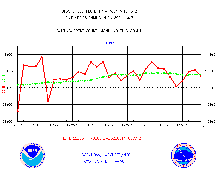
LEO-GEO satellite AMVs from UWisc. |
47030 |
54393 |
86.5 % |
|||||||||||
Buoys decoded from FM-13 format (moored) |
815 |
786 |
103.7 % |
|||||||||||
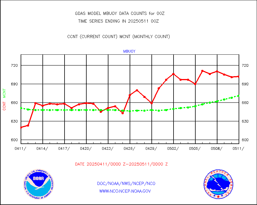
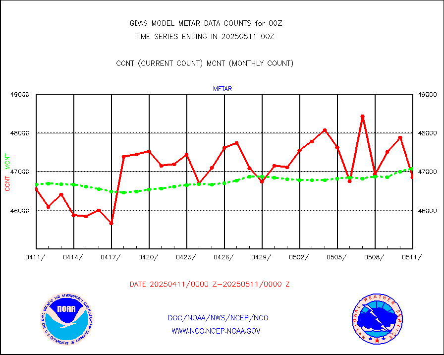
Aviation - METAR |
47795 |
47011 |
101.7 % |
|||||||||||
METOP 1-2 IASI 1C radiance data (varbl. channels) |
648000 |
632255 |
102.5 % |
|||||||||||
NEXRAD Vel Azm Dsp(VAD) winds via radar coded msg |
0 |
0 |
n/a |
|||||||||||
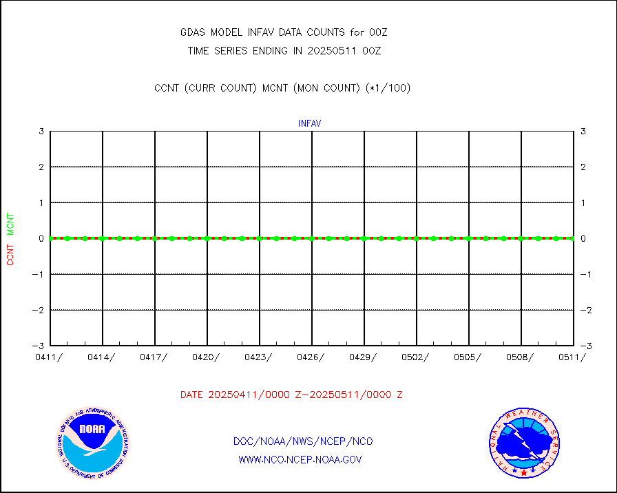
Aura Ozone Monitoring Instrument (OMI) data |
0 |
0 |
n/a |
|||||||||||
NOAA 16-19 Solar Backscatter UV-2 rad frm V8 BUFR |
0 |
0 |
n/a |
|||||||||||
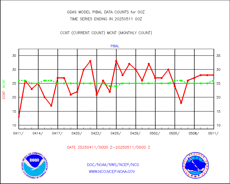
PIBAL (from PILOT, PILOT SHIP, PILOT MOBIL) |
25 |
26 |
96.2 % |
|||||||||||
Profilr winds from PIBAL (PILOT,PILOT SHIP/MOBIL) |
0 |
0 |
n/a |
|||||||||||
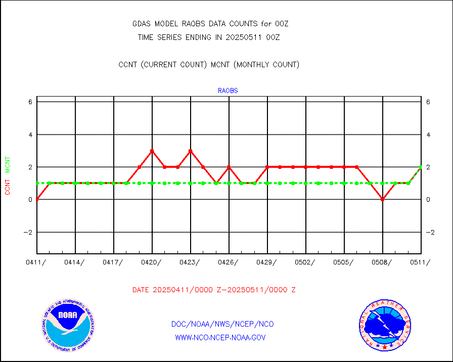
Rawinsonde - fixed land (from TEMP or PILOT) |
592 |
591 |
100.2 % |
|||||||||||
Rawinsonde - mobile land (from TEMP/PILOT MOBIL) |
0 |
0 |
n/a |
|||||||||||
Rawinsonde - ship (from TEMP SHIP, PILOT SHIP) |
1 |
1 |
100.0 % |
|||||||||||
Flight level reconnaissance aircraft data |
0 |
1 |
0.0 % |
|||||||||||
Ship - manual and automatic, restricted |
166 |
223 |
74.4 % |
|||||||||||
Ship - manual and automatic, restricted (BUFR) |
1092 |
923 |
118.3 % |
|||||||||||
Ship - manual and automatic, unrestricted |
790 |
734 |
107.6 % |
|||||||||||
Ship - manual and automatic, unrestricted (BUFR) |
6324 |
6263 |
101.0 % |
|||||||||||
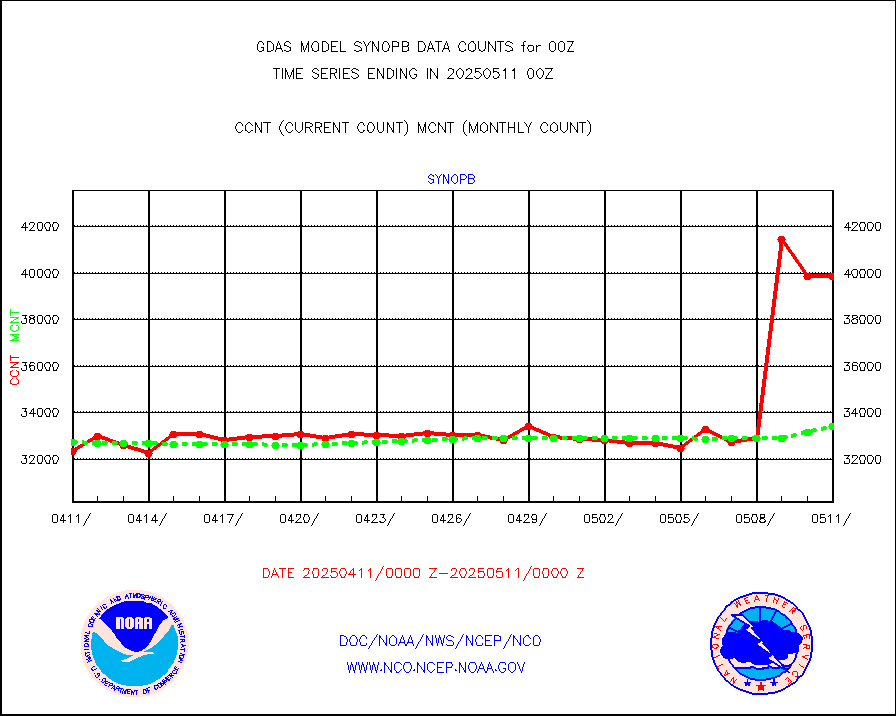
Synoptic - fixed manual & auto (decoded fr BUFR) |
41312 |
41079 |
100.6 % |
|||||||||||
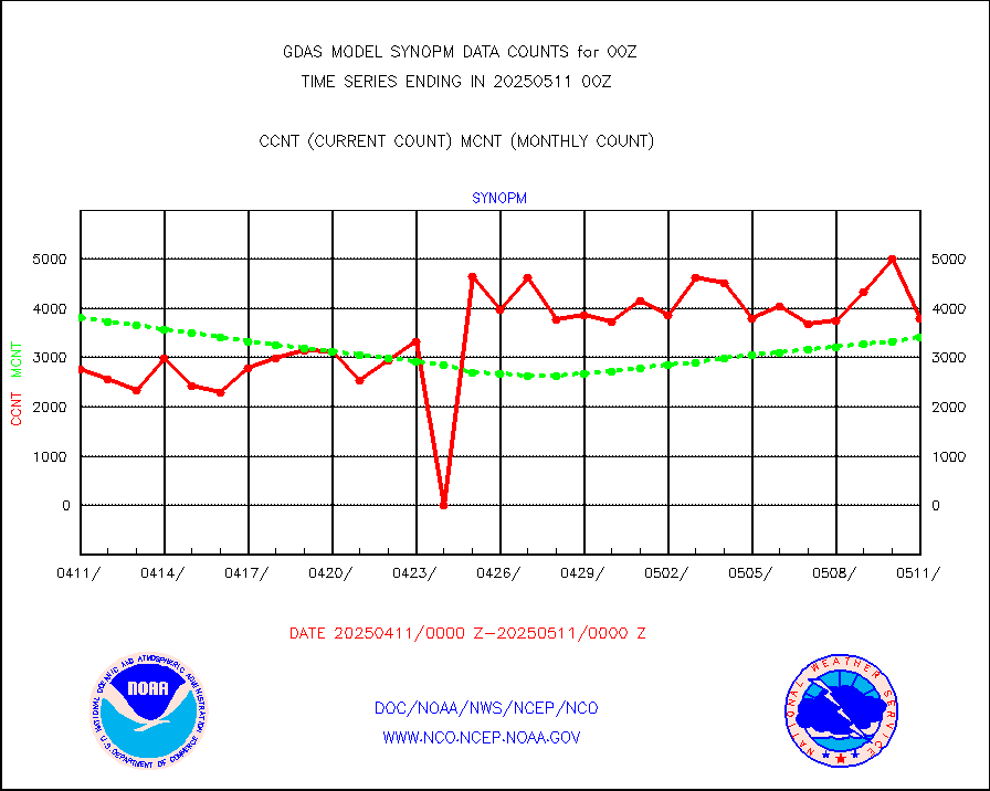
Synoptic - mobile manual and automatic |
4244 |
4195 |
101.2 % |
|||||||||||
Synoptic - restricted (WMO Res 40) manual & auto. |
5 |
5 |
100.0 % |
|||||||||||
Synoptic - restricted (WMO Res 40)(decoded BUFR) |
2310 |
2334 |
99.0 % |
|||||||||||
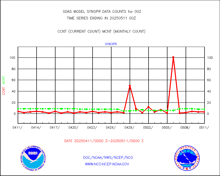
Synoptic - mobile manual & auto (decoded fr BUFR) |
253 |
265 |
95.5 % |
|||||||||||
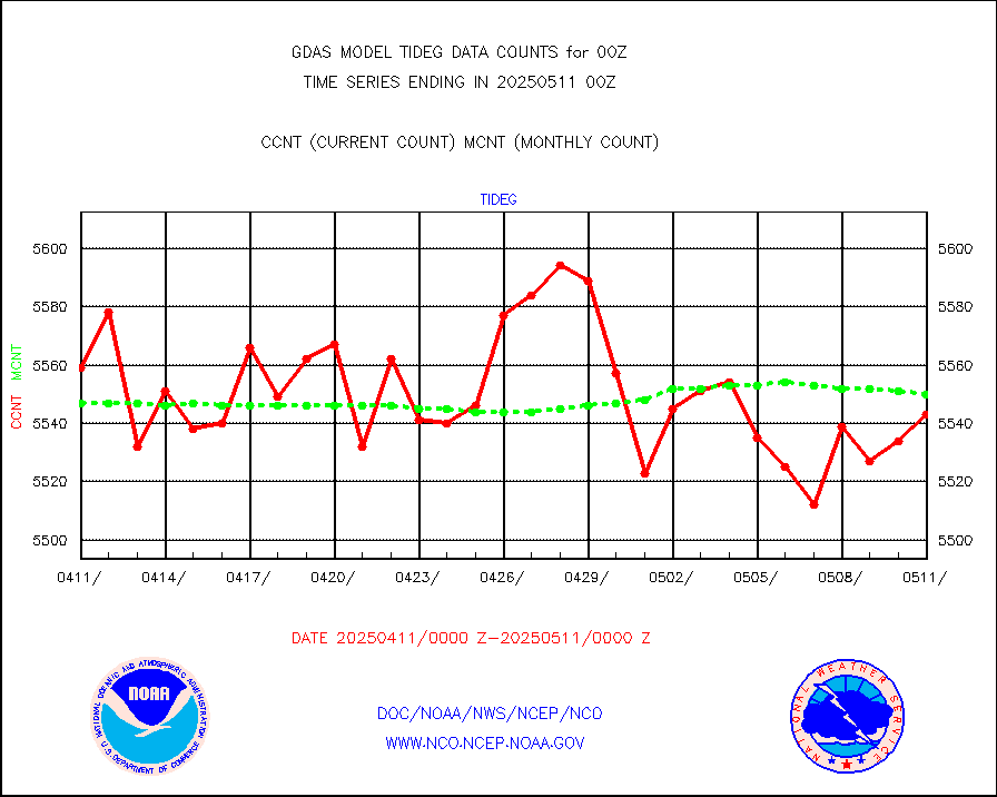
Tide gauge reports decoded from CREX format |
5635 |
5597 |
100.7 % |
|||||||||||
MTSAT/JMA visible derived cloud motion |
31382 |
31119 |
100.8 % |
|||||||||||
METEOSAT/EUMETSAT visible drv cld motion NBseq |
12360 |
13118 |
94.2 % |
|||||||||||
| Data Types of Opportunity with Normal Counts | ||||||||||||||
|---|---|---|---|---|---|---|---|---|---|---|---|---|---|---|
| Type | Description | Hourly Count | Monthly Average | Percent (%) of Monthly Mean | ||||||||||
GOES-16&up/NESDIS ir short-wv derived cld motion |
87754 |
89463 |
98.1 % |
|||||||||||
MDCRS ACARS acft data (ARINC via AFWA)(AIREP fmt) |
0 |
0 |
n/a |
|||||||||||
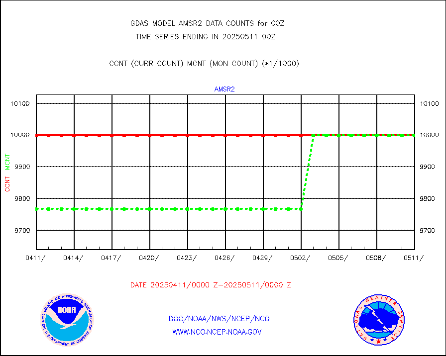
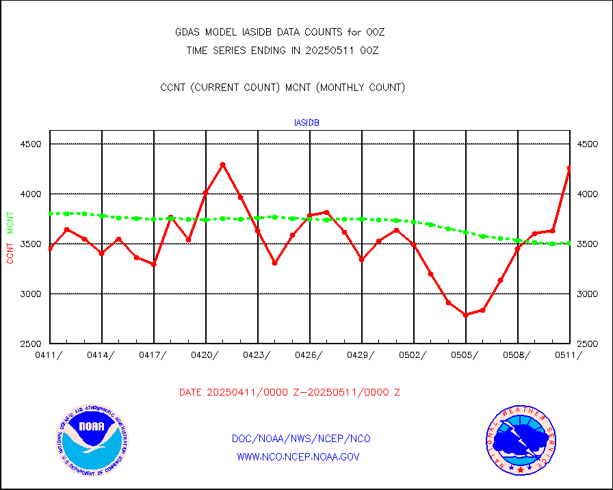
GCOM-W AMSR2 1B brightness temperatures |
9999999 |
9999999 |
100.0 % |
|||||||||||
NPP/NOAA-20 ATMS bright. temps-direct b-cast SSEC |
572544 |
526200 |
108.8 % |
|||||||||||
POES/NESDIS - processed ATOVS soundings/radiances |
0 |
0 |
n/a |
|||||||||||
A.M.(N17,M2,M3) AVHRR GAC NCEP-proc clr&sea btmps |
8061039 |
7651754 |
105.3 % |
|||||||||||
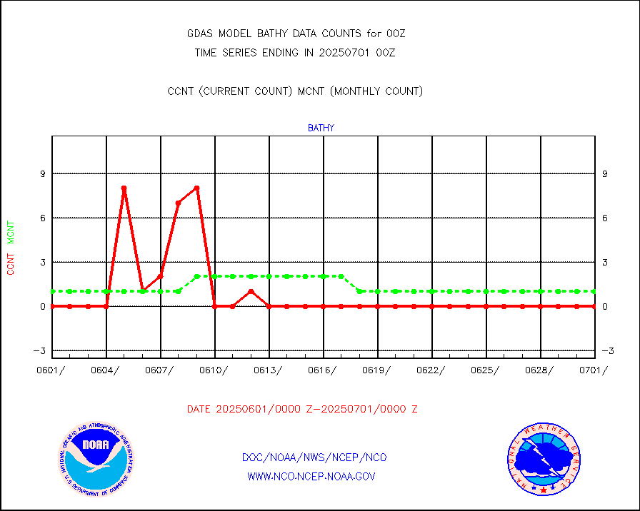
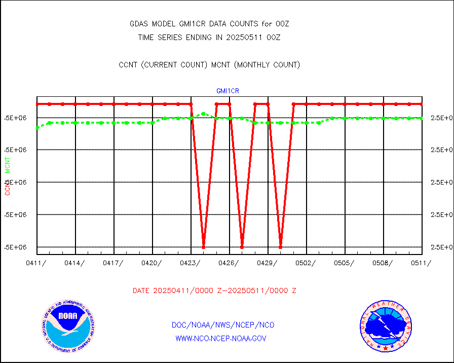
eXpendable BathyThermograph, mooring (BATHY fmt) |
0 |
1 |
0.0 % |
|||||||||||
Canadian AMDAR aircraft data (decoded from BUFR) |
0 |
0 |
n/a |
|||||||||||
NPP/NOAA-20 CrIS full spctrl radn (431 ch subset) |
1458000 |
1457748 |
100.0 % |
|||||||||||
NPP/NOAA-20 CrIS full spctrl radn dir brdcst SSEC |
185760 |
189915 |
97.8 % |
|||||||||||
Coast Guard |
38 |
39 |
97.4 % |
|||||||||||
Drifting buoys (decoded from BUFR) |
8759 |
9136 |
95.9 % |
|||||||||||
Dropwinsonde (decoded from BUFR) |
43 |
41 |
104.9 % |
|||||||||||
METOP 1-2 IASI 1C radiance data vbl chn from RARS |
149517 |
149567 |
100.0 % |
|||||||||||
NOAA 18-19 & METOP 1-2 MHS proc. btemps from RARS |
1438597 |
1874458 |
76.7 % |
|||||||||||
GOES/NESDIS (11x17 f-o-v) imager clear radiances |
0 |
0 |
n/a |
|||||||||||
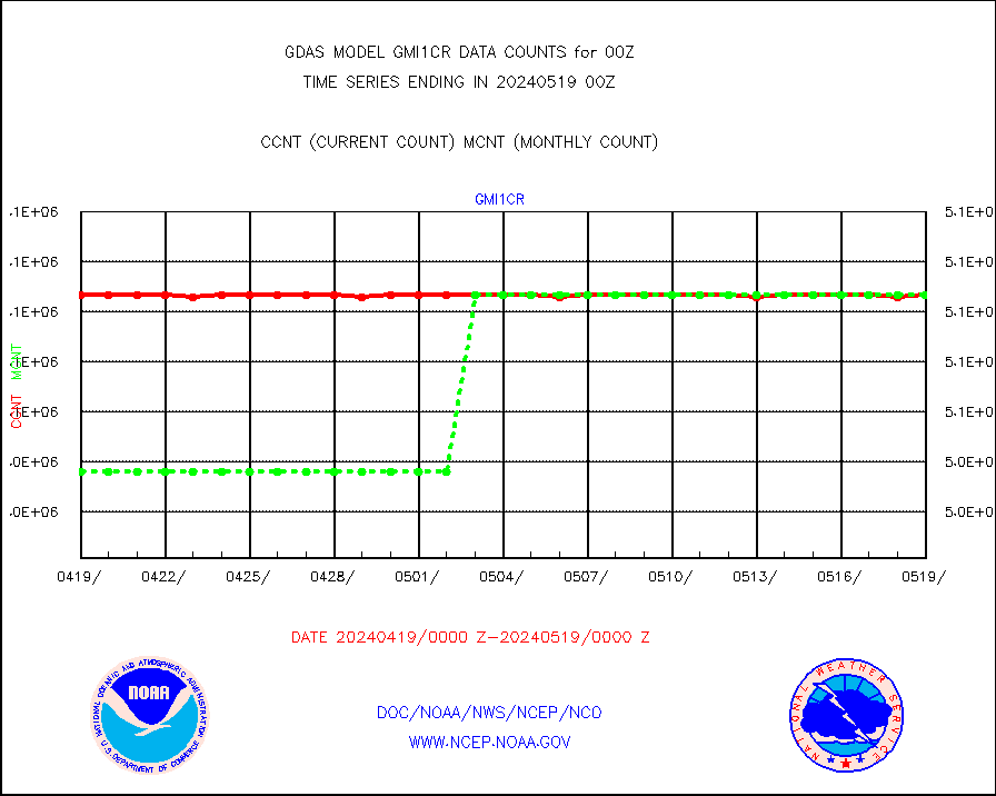
GPM GMI Level 1C-R brightness temperatures |
2541721 |
2541692 |
100.0 % |
|||||||||||
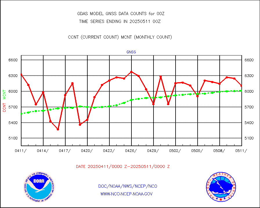
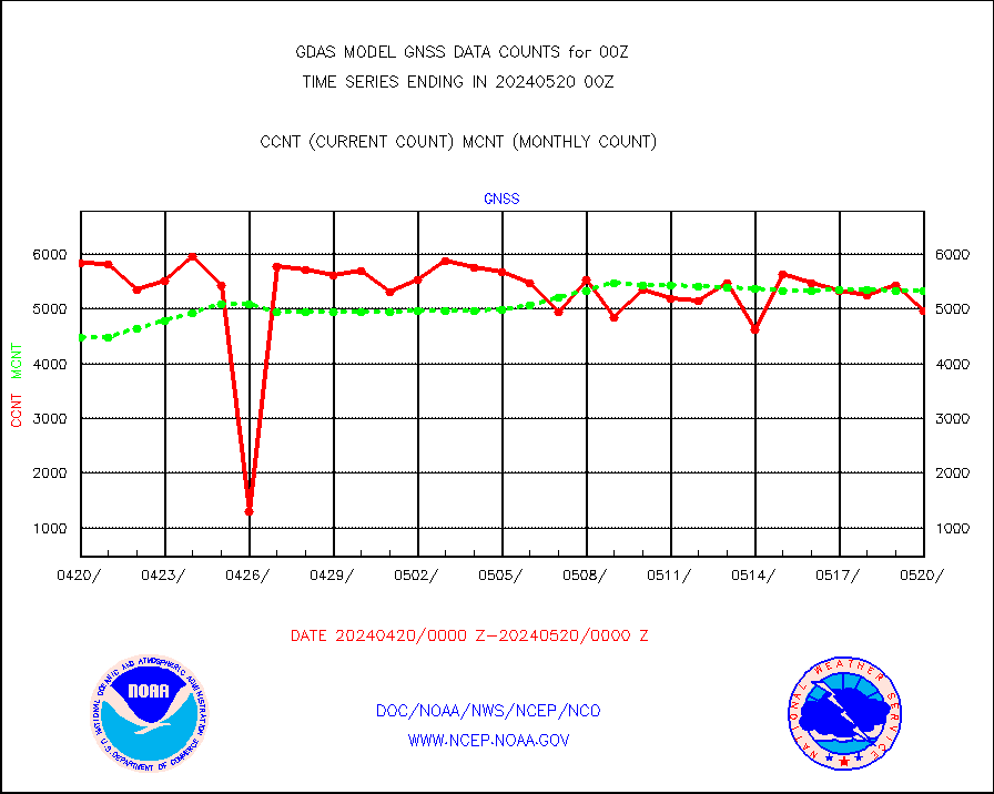
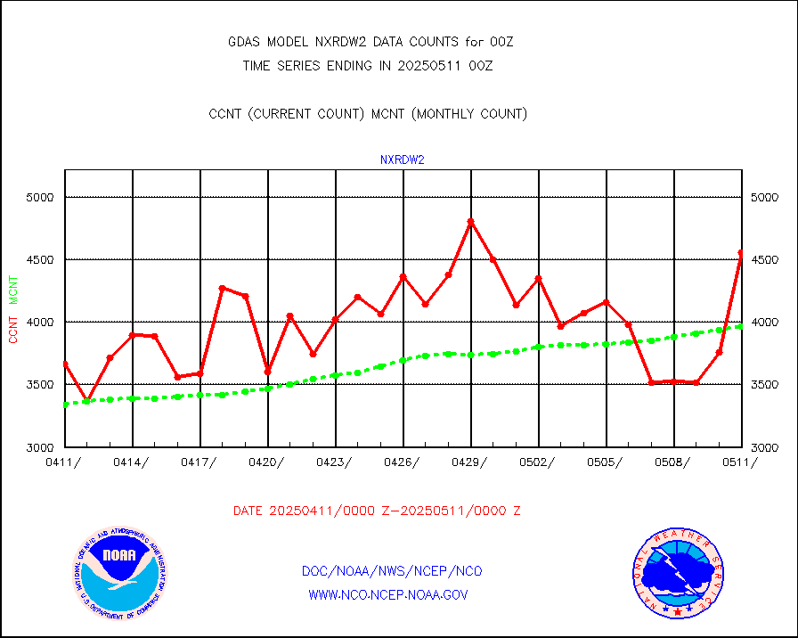
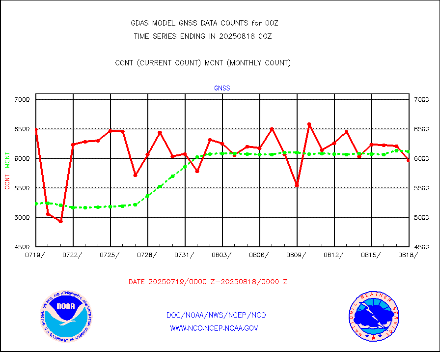
Grnd-based Gbl Navigation Sat System (GNSS) data |
4372 |
5151 |
84.9 % |
|||||||||||
METOP 1-2 Global Ozone Monitoring Exp.-2 (GOME-2) |
79501 |
79806 |
99.6 % |
|||||||||||
INSAT/KALPANA India wvpr derived cloud motion |
0 |
0 |
n/a |
|||||||||||
GOES-16&up/NESDIS wv imgr/deep-lyr derivd cld mtn |
124069 |
104735 |
118.5 % |
|||||||||||
METEOSAT/EUMETSAT wvpr imgr drv cld motion NBseq |
204484 |
219258 |
93.3 % |
|||||||||||
METOP 1-2 IASI 1C radiances-direct broadcast SSEC |
362055 |
396298 |
91.4 % |
|||||||||||
VIIRS (NPP/NOAA-20) ir lg-wv drv cloud motion(NB) |
114057 |
126969 |
89.8 % |
|||||||||||
AVHRR (NOAA/METOP) ir lg-wave derived cld motion |
0 |
0 |
n/a |
|||||||||||
AVHRR (METOP) ir lg-wave derived cld motion |
57803 |
55885 |
103.4 % |
|||||||||||
INSAT/KALPANA India ir lg-wave derived cld motion |
0 |
0 |
n/a |
|||||||||||
Korean AMDAR aircraft data (decoded from BUFR) |
442 |
458 |
96.5 % |
|||||||||||
Moored buoys (decoded from BUFR) |
8120 |
7972 |
101.9 % |
|||||||||||
NEXRAD Vel Azm Dsp(VAD) winds via Level 2 decoder |
5215 |
4884 |
106.8 % |
|||||||||||
OMPS Limb Profiler ozone data (NPP) |
1798 |
1571 |
114.4 % |
|||||||||||
OMPS nadir profile ozone (Version 8 BUFR) |
3484 |
3368 |
103.4 % |
|||||||||||
OMPS total column ozone (Version 8 BUFR) |
2039294 |
2020190 |
100.9 % |
|||||||||||
PIBAL (decoded from BUFR) |
4 |
3 |
133.3 % |
|||||||||||
Manual PIREP aircraft data (dcded from AIREP fmt) |
599 |
625 |
95.8 % |
|||||||||||
Multi-Agency Profiler (MAP) and SODAR winds |
471 |
440 |
107.0 % |
|||||||||||
Rawinsonde - fixed land (decoded from BUFR) |
366 |
379 |
96.6 % |
|||||||||||
Rawinsonde - mobile land (decoded from BUFR) |
0 |
0 |
n/a |
|||||||||||
Rawinsonde - ship (decoded from BUFR) |
5 |
3 |
166.7 % |
|||||||||||
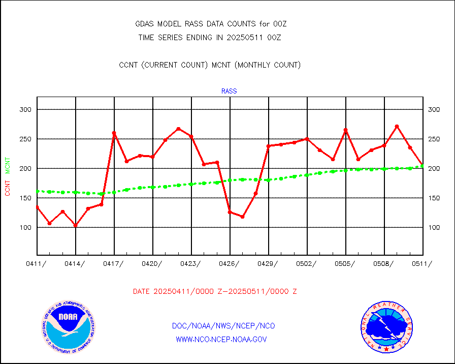
RASS temperatures (NOAA and Multi-Agency) |
182 |
181 |
100.6 % |
|||||||||||
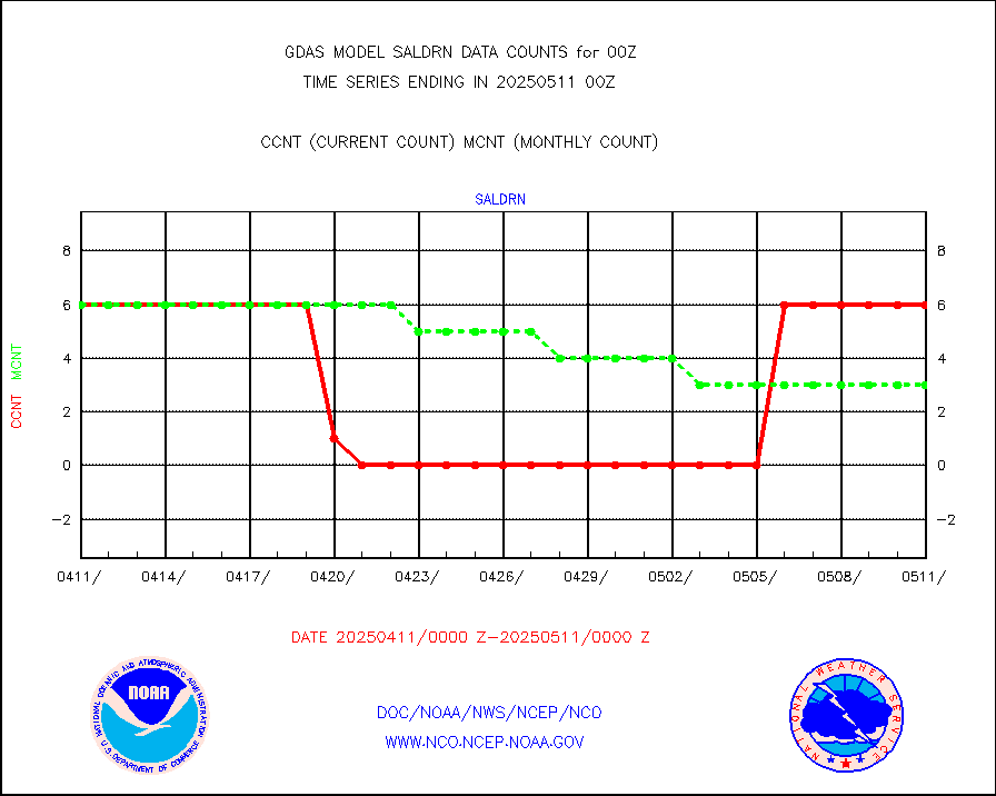
Surface Marine Saildrone (decoded from BUFR) |
6 |
6 |
100.0 % |
|||||||||||
METEOSAT-10 2nd Gen SEVIRI All Sky Radiance(proc) |
444053 |
451901 |
98.3 % |
|||||||||||
NOW COVER, DEPTH/DENSITY AND WATER EQUIVALENT |
18076 |
17661 |
102.3 % |
|||||||||||
DMSP SSM/IS 1C radiance data (Unified Pre-Proc.) |
870000 |
861904 |
100.9 % |
|||||||||||
NPP/NOAA-20 VIIRS SST - CLEAR & OVER WATER |
31 |
31 |
100.0 % |
|||||||||||
NPP/NOAA-20 VIIRS SST - PROBABLY CLR & OVER WATER |
9999999 |
9999999 |
100.0 % |
|||||||||||
Synoptic - fixed manual and automatic |
6750 |
6684 |
101.0 % |
|||||||||||
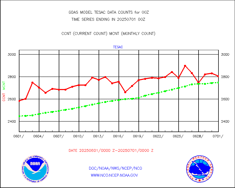
CTD probe, Argo prflng float, mooring (TESAC fmt) |
2838 |
2756 |
103.0 % |
|||||||||||
TAMDAR aircft data-all types(from Panasonic,BUFR) |
331 |
300 |
110.3 % |
|||||||||||
ThermoSalinoGraph (TSG) TRACKOB format) |
737 |
793 |
92.9 % |
|||||||||||
INSAT/KALPANA India visible derived cloud motion |
0 |
0 |
n/a |
|||||||||||
GOES-16&up/NESDIS visible derived cloud motion |
2319155 |
2016260 |
115.0 % |
|||||||||||


