| Critical Data with Normal Counts |
|---|
| Type | Description | Hourly Count | Monthly Average | Percent (%) of Monthly Mean | UTC Time Window |
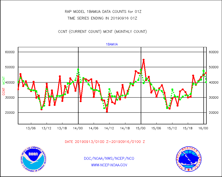
1bamua |
NOAA 15-19 & METOP 1-2 AMSU-A NCEP-proc. br.temps |
46334 |
40028 |
115.8 % |
1522.00-1603.99 |
1bhrs4 |
NOAA 18-19 & METOP 1-2 HIRS-4 NCEP-proc. br.temps |
95790 |
82581 |
116.0 % |
1522.00-1603.99 |
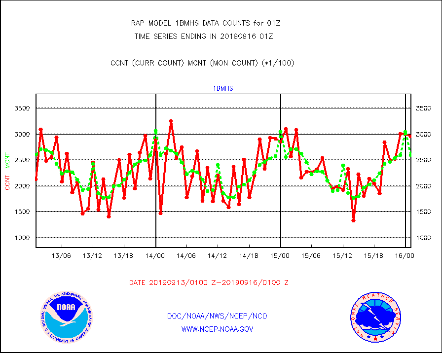
1bmhs |
NOAA 18-19 & METOP 1-2 MHS NCEP-proces. br. temps |
296094 |
259403 |
114.1 % |
1522.00-1603.99 |
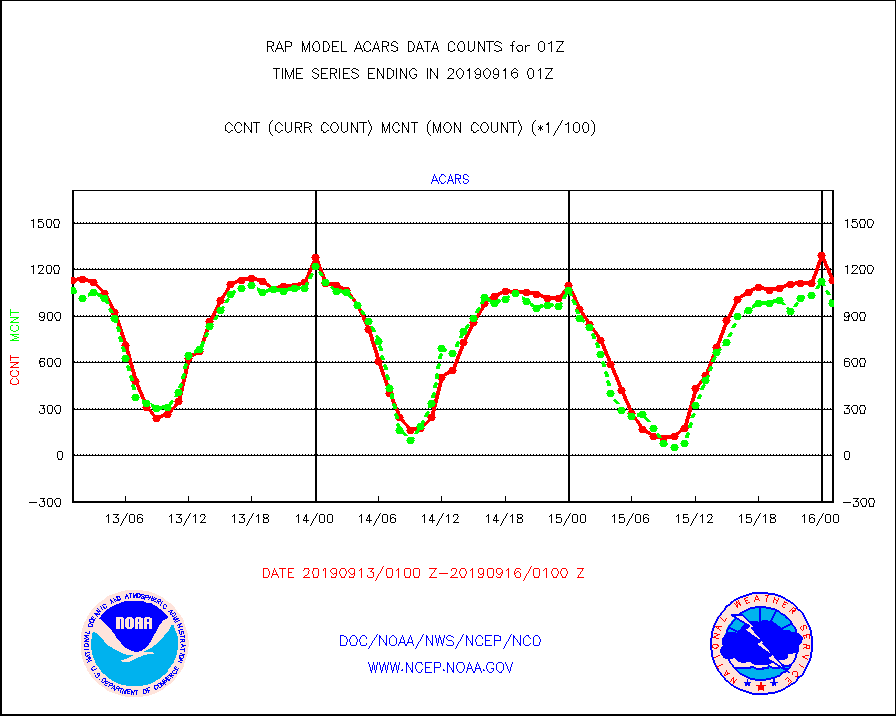
acars |
MDCRS ACARS acft data from ARINC(dcded from BUFR) |
113186 |
97968 |
115.5 % |
1521.75-1604.25 |
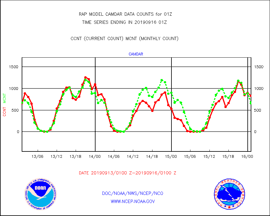
camdar |
Canadian AMDAR aircraft data (decoded from BUFR) |
833 |
660 |
126.2 % |
1521.75-1604.25 |
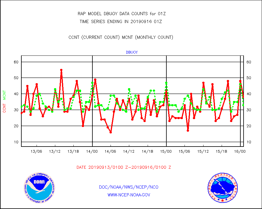
dbuoy |
Buoys decoded from FM-18 fmt (moored or drifting) |
38 |
33 |
115.2 % |
1600.50-1601.50 |
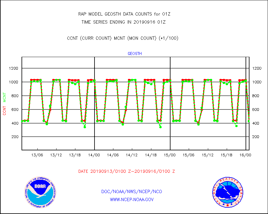
geosth |
GOES/NESDIS hi-resol. (1x1 f-o-v) cloud data |
43570 |
42744 |
101.9 % |
1523.75-1600.99 |
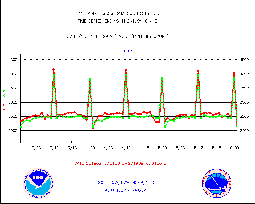
gnss |
Grnd-based Gbl Navigation Sat System (GNSS) data |
2196 |
2155 |
101.9 % |
1523.95-1600.05 |
h20mo |
MODIS (AQUA/TERRA) wvpr imager derived cld motion |
0 |
0 |
n/a |
1522.50-1603.50 |
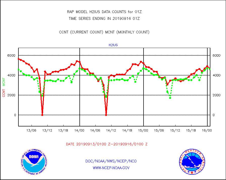
h2ius |
GOES/NESDIS water vapor imager derived cld motion |
4650 |
4603 |
101.0 % |
1600.00-1600.99 |
infmo |
MODIS (AQUA/TERRA) ir l-wave derived cloud motion |
0 |
0 |
n/a |
1522.50-1603.50 |
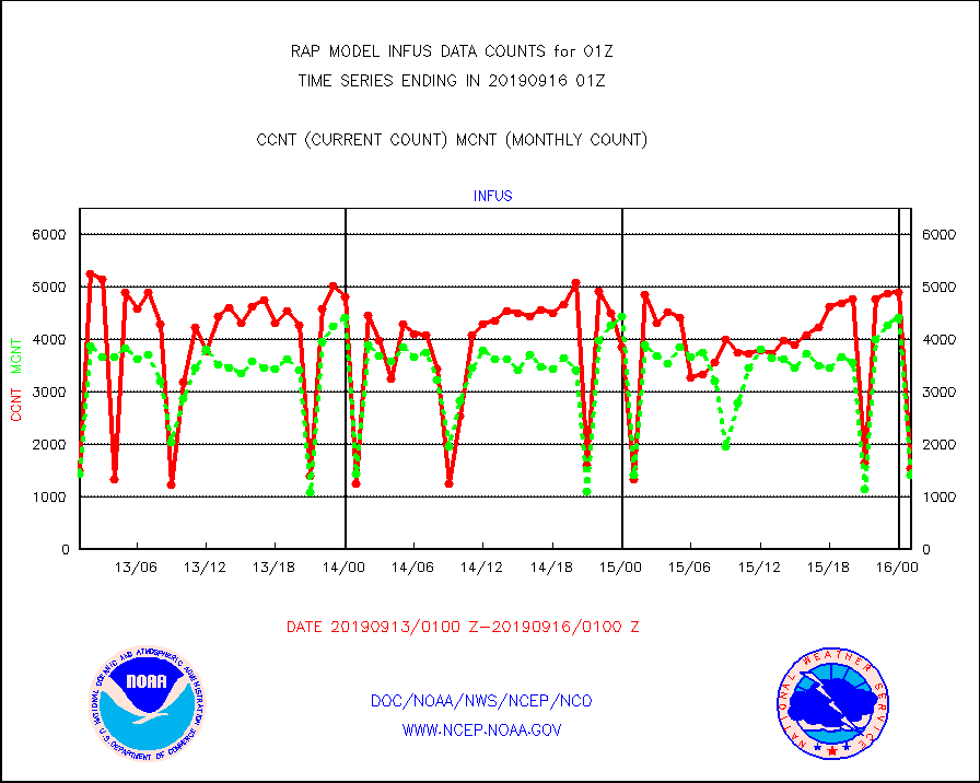
infus |
GOES/NESDIS infrared lg-wave derived cloud motion |
1540 |
1410 |
109.2 % |
1600.00-1600.99 |
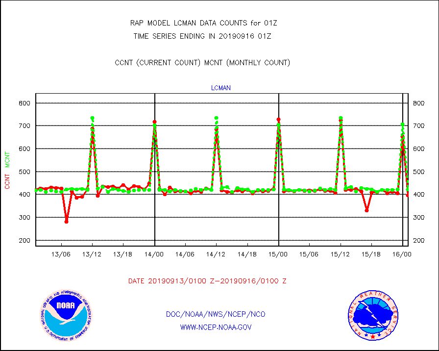
lcman |
Land-based CMAN stations decoded from CMAN format |
396 |
422 |
93.8 % |
1600.50-1601.50 |
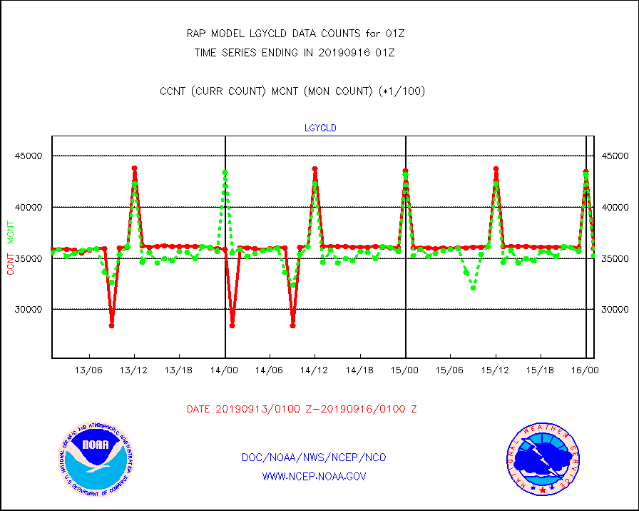
lgycld |
GOES/NASA(Langley) hi-res. (1x1 f-o-v) cloud data |
3594176 |
3525721 |
101.9 % |
1600.50-1601.50 |
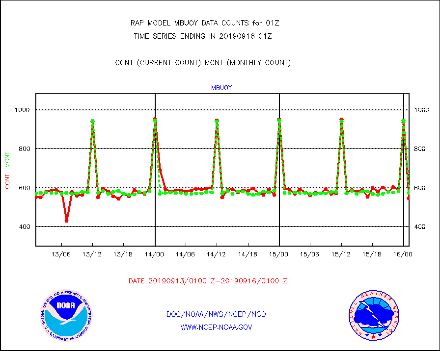
mbuoy |
Buoys decoded from FM-13 format (moored) |
545 |
573 |
95.1 % |
1600.50-1601.50 |
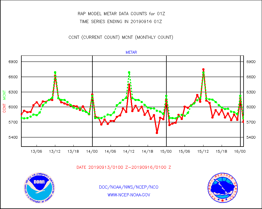
metar |
Aviation - METAR |
5705 |
5776 |
98.8 % |
1600.50-1601.50 |
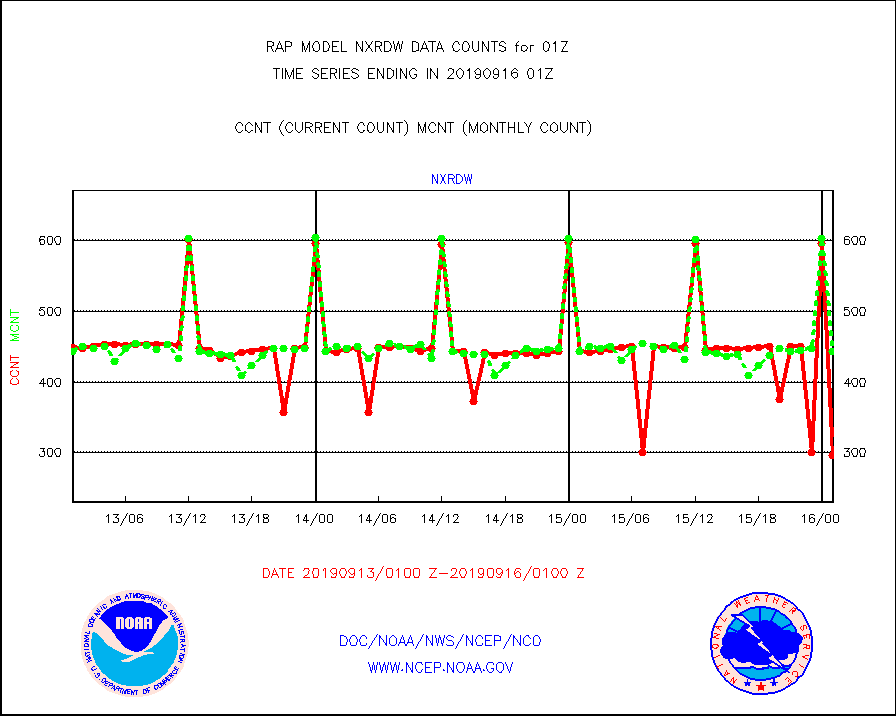
nxrdw |
NEXRAD Vel Azm Dsp(VAD) winds via radar coded msg |
297 |
443 |
67.0 % |
1600.00-1602.00 |
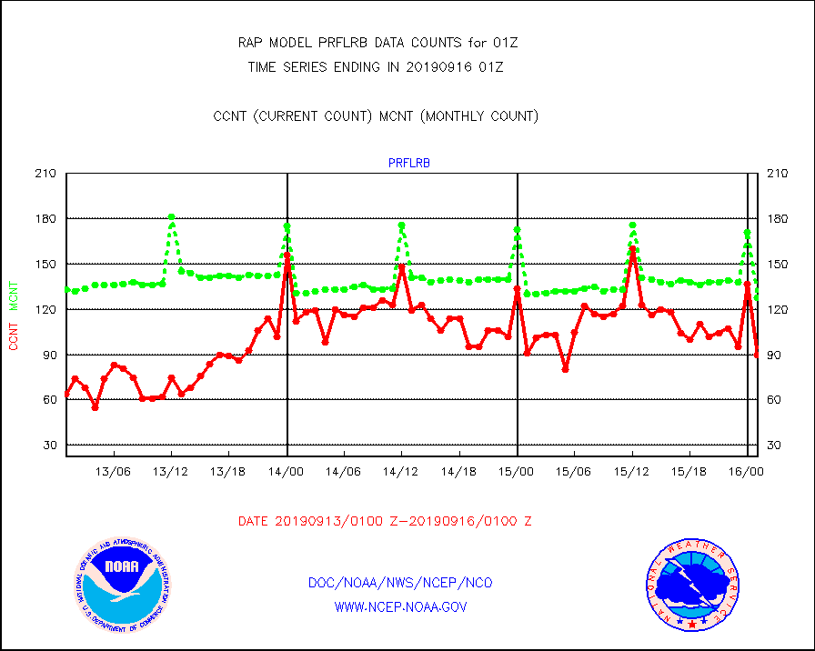
prflrb |
Multi-Agency Profiler (MAP) and SODAR winds |
90 |
128 |
70.3 % |
1523.50-1602.50 |
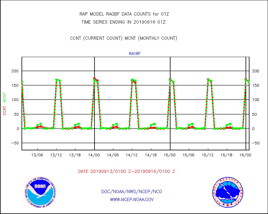
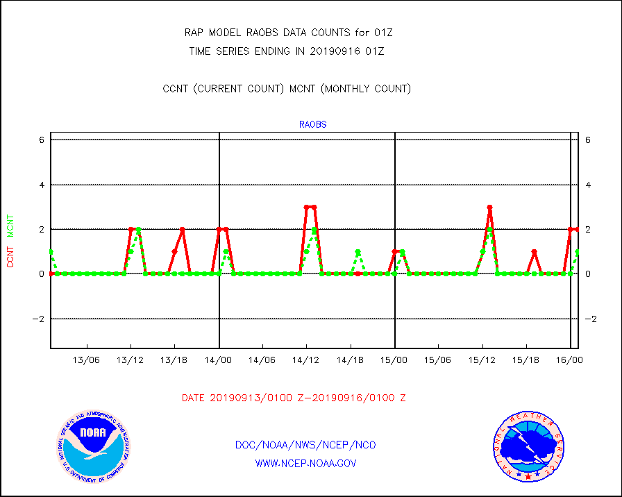
raobf |
Rawinsonde - fixed land (from TEMP or PILOT) |
161 |
162 |
99.4 % |
1600.00-1602.00 |
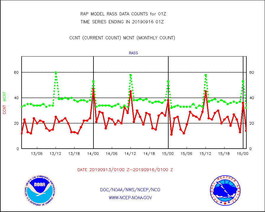
rass |
RASS temperatures (NOAA and Multi-Agency) |
14 |
32 |
43.8 % |
1600.50-1601.50 |
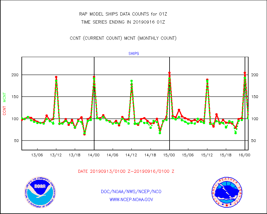
ships |
Ship - manual and automatic, restricted |
103 |
101 |
102.0 % |
1600.50-1601.50 |
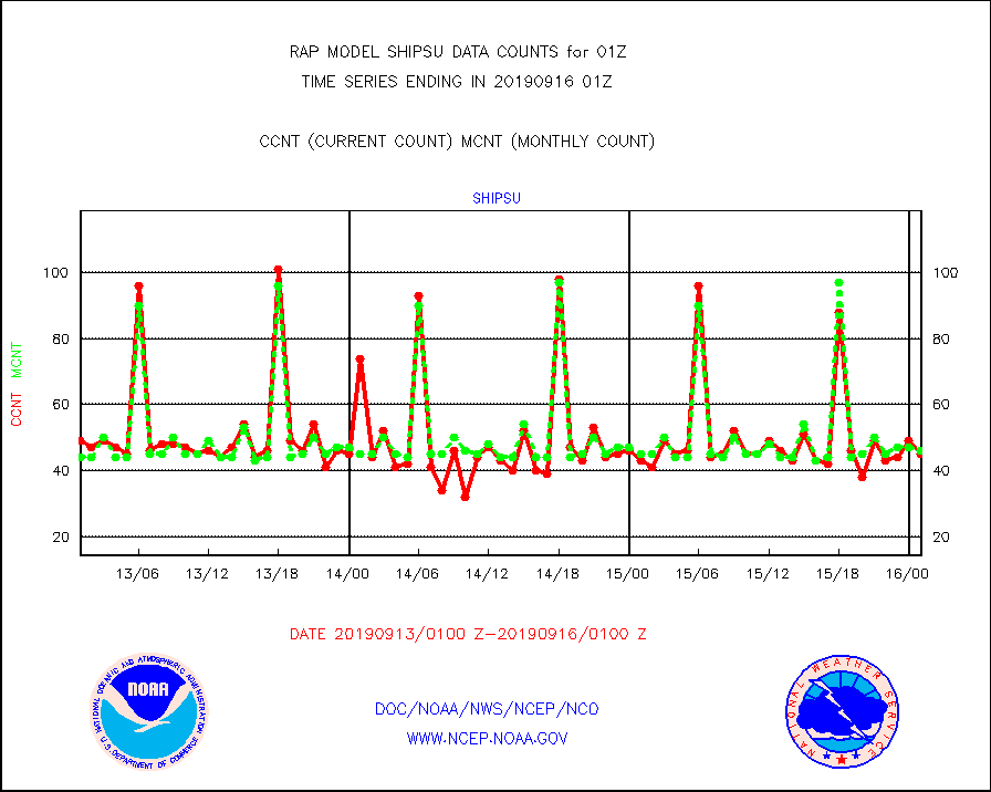
shipsu |
Ship - manual and automatic, unrestricted |
45 |
46 |
97.8 % |
1600.50-1601.50 |
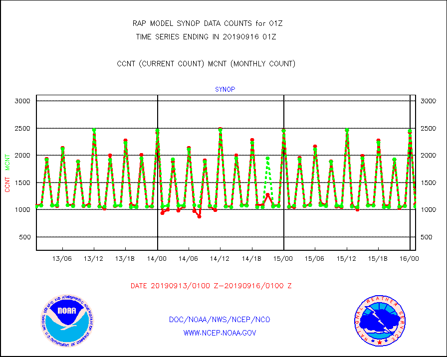
synop |
Synoptic - fixed manual and automatic |
1104 |
1054 |
104.7 % |
1600.50-1601.50 |
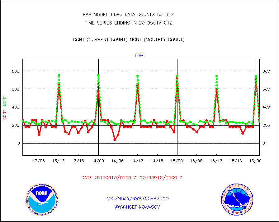
tideg |
Tide gauge reports decoded from CREX format |
258 |
243 |
106.2 % |
1600.50-1601.50 |
| Data Types of Opportunity with Normal Counts |
|---|
| Type | Description | Hourly Count | Monthly Average | Percent (%) of Monthly Mean | UTC Time Window |
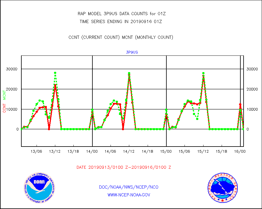
3p9us |
GOES/NESDIS infrared shrt-wave derived cld motion |
0 |
0 |
n/a |
1600.00-1600.99 |
acarsa |
MDCRS ACARS acft data (ARINC via AFWA)(AIREP fmt) |
0 |
0 |
n/a |
1521.75-1604.25 |
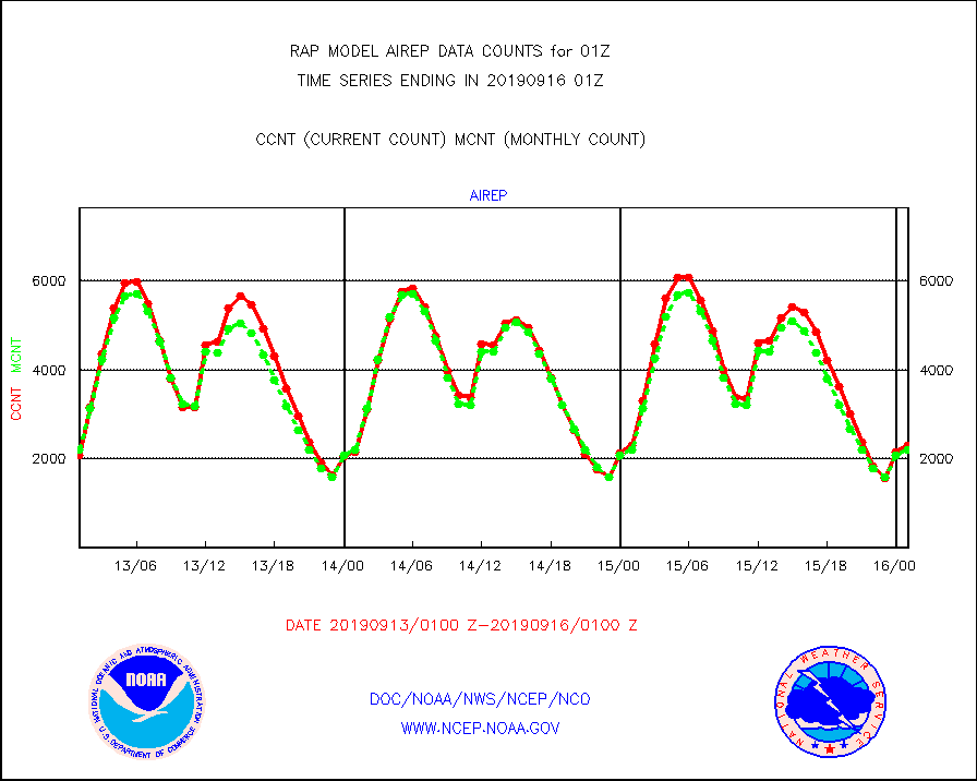
airep |
Manual AIREP aircraft data (dcded from AIREP fmt) |
2304 |
2197 |
104.9 % |
1521.75-1604.25 |
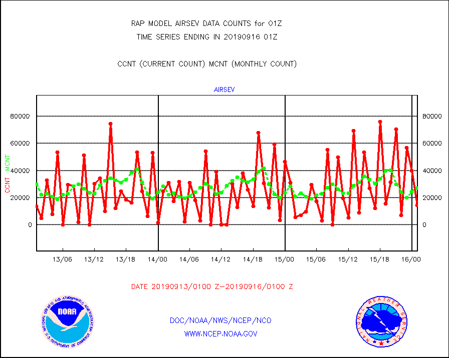
airsev |
AQUA AIRS/AMSU-A/HSB brightness temps- every FOV |
14152 |
27059 |
52.3 % |
1522.00-1603.99 |
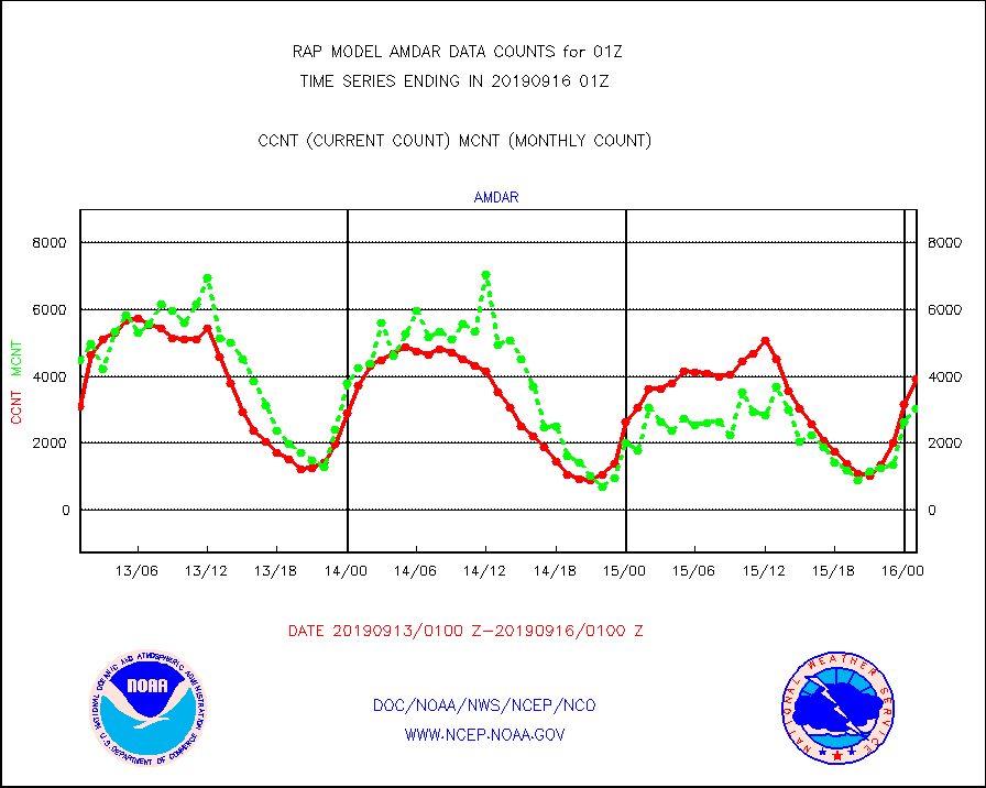
amdar |
AMDAR aircraft data (decoded from AMDAR format) |
3917 |
3034 |
129.1 % |
1521.75-1604.25 |
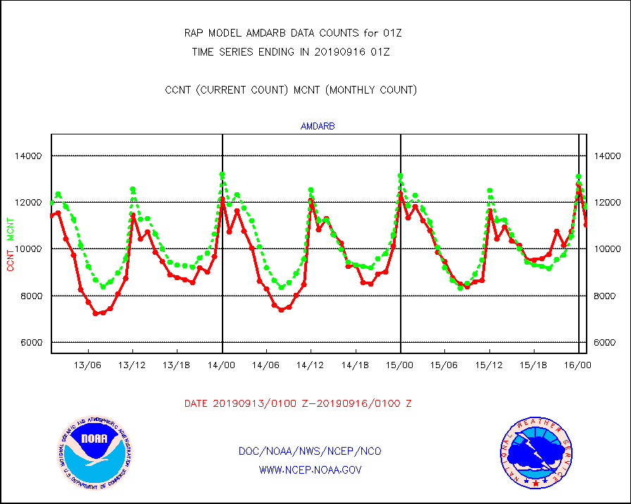
amdarb |
AMDAR aircraft data (decoded from BUFR) |
11035 |
11812 |
93.4 % |
1521.75-1604.25 |
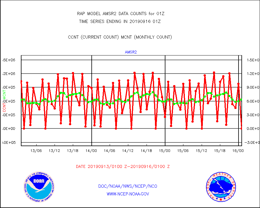
amsr2 |
GCOM-W AMSR2 1B brightness temperatures |
995 |
634025 |
0.2 % |
1522.00-1522.99 |
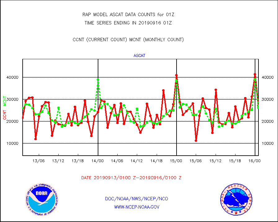
ascat |
METOP 1-2 ASCAT products |
27180 |
26246 |
103.6 % |
1523.00-1603.00 |
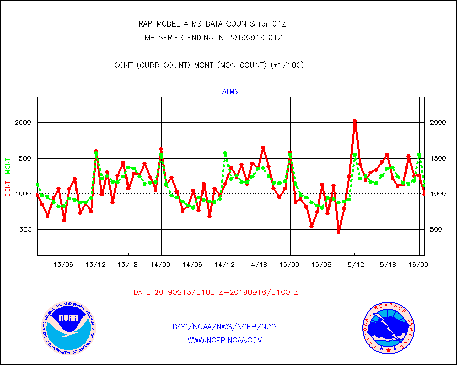
atms |
NPP Adv. Tech. Microwave Sounder (ATMS) br. temps |
99447 |
112076 |
88.7 % |
1523.00-1602.99 |
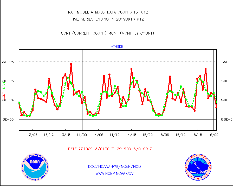
atmsdb |
NPP Adv Tech MW Sndr(ATMS) b. temps-dir bcst SSEC |
31074 |
45175 |
68.8 % |
1523.00-1602.99 |
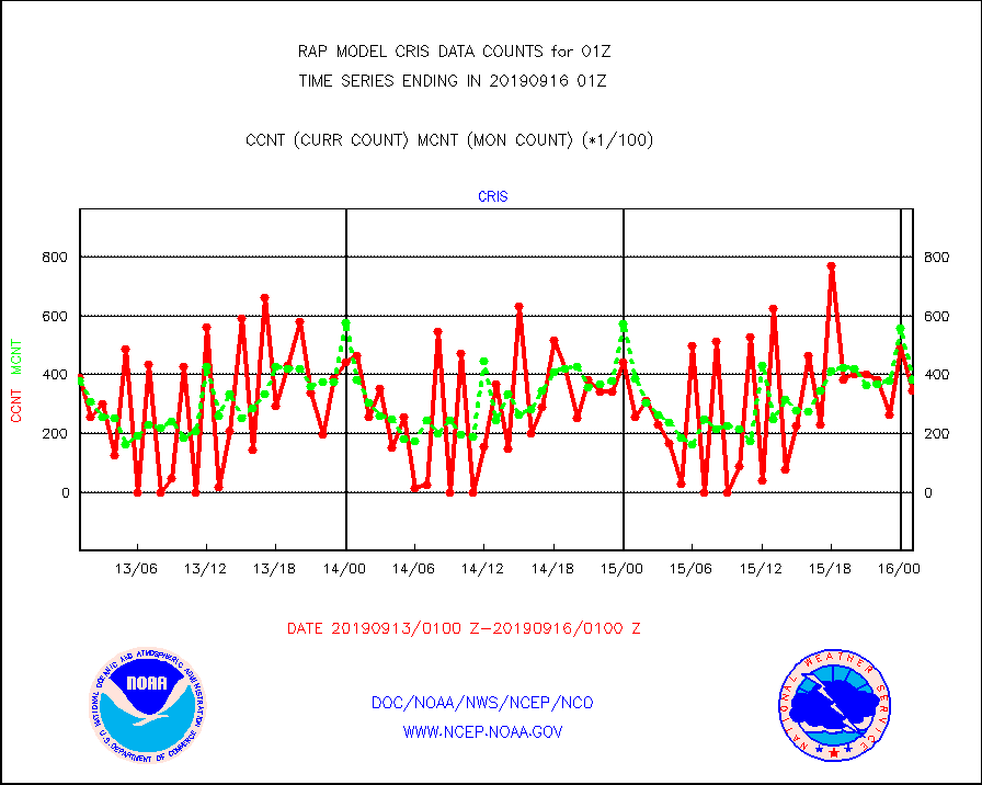
cris |
NPP Cross-track Infrared Sounder (CrIS) radiances |
34835 |
38355 |
90.8 % |
1523.00-1602.99 |
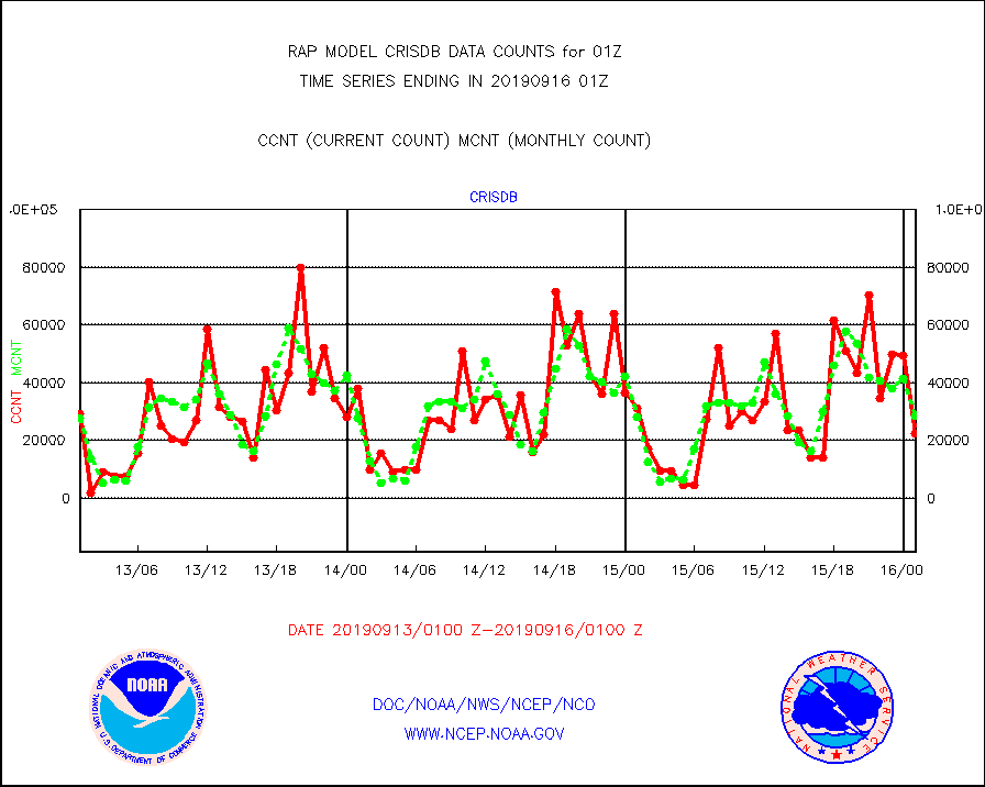
crisdb |
NPP Crss-trk IR Sndr(CrIS) radiance-dir bcst SSEC |
22370 |
28308 |
79.0 % |
1523.00-1602.99 |
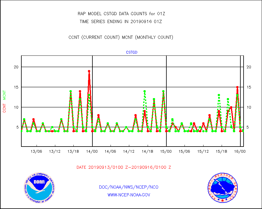
cstgd |
Coast Guard |
4 |
4 |
100.0 % |
1600.50-1601.50 |
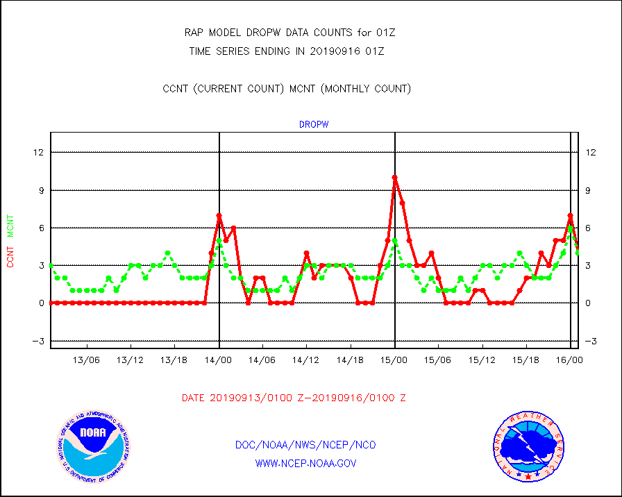
dropw |
Dropwinsonde (from TEMP DROP) |
4 |
4 |
100.0 % |
1600.00-1602.00 |
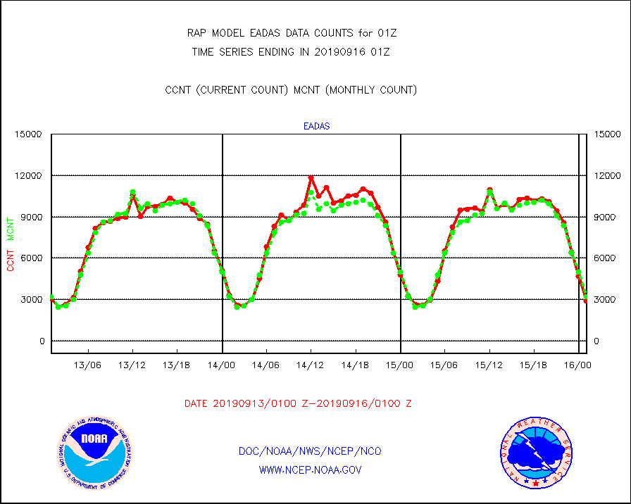
eadas |
E-AMDAR (European AMDAR acft decoded from BUFR) |
2893 |
3197 |
90.5 % |
1521.75-1604.25 |
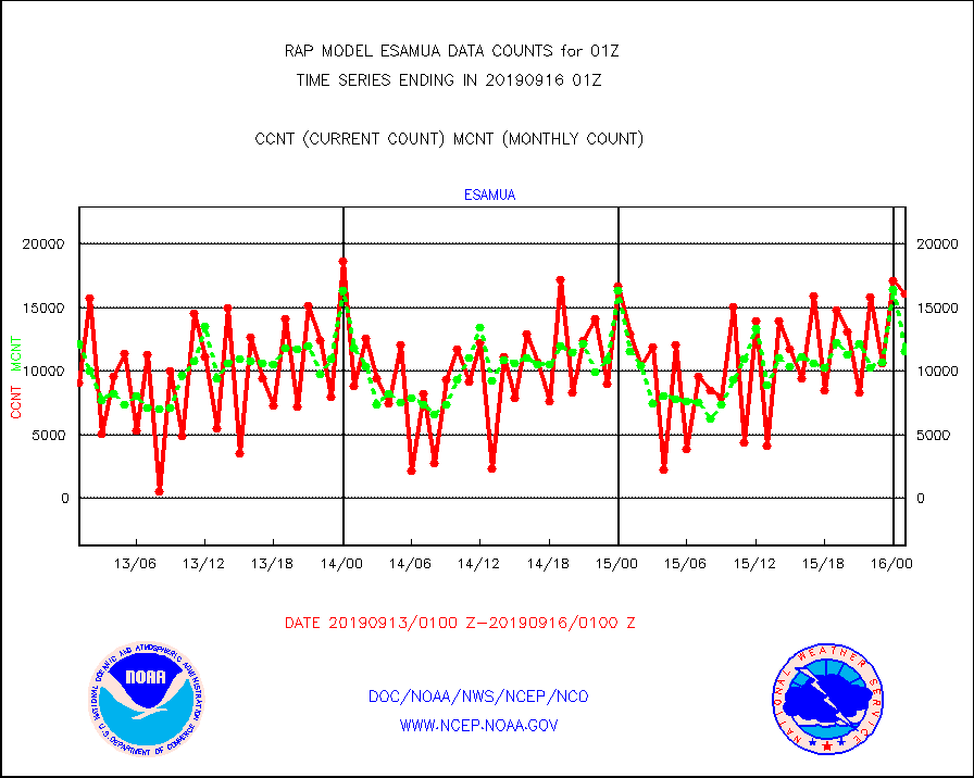
esamua |
NOAA 15-19 & METOP 1-2 AMSU-A proc btmps frm RARS |
16078 |
11600 |
138.6 % |
1600.00-1602.00 |
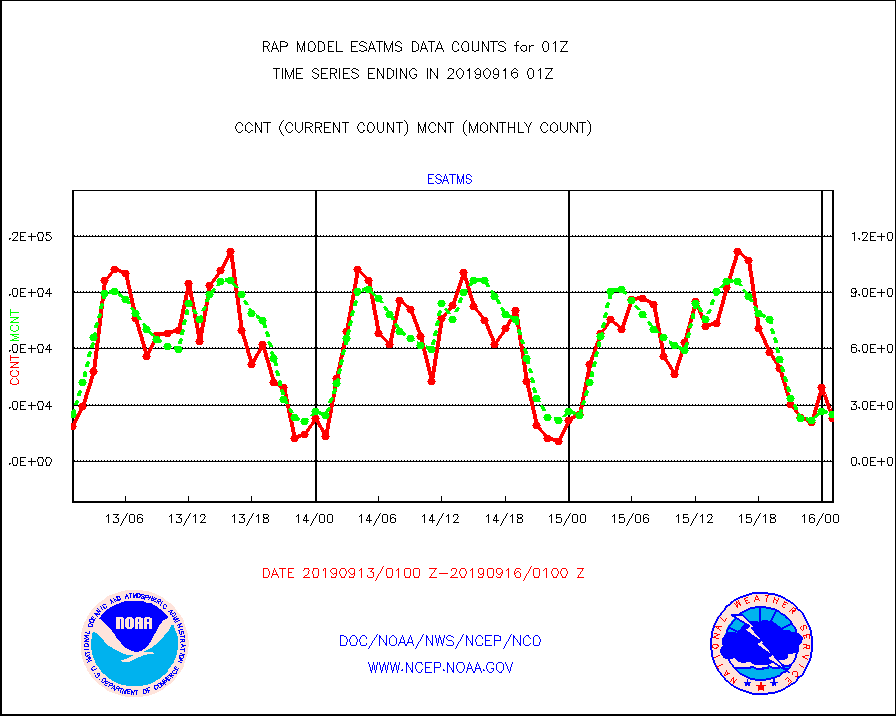
esatms |
NPP Adv. Tech. MW Sndr (ATMS) br. temps from RARS |
22626 |
25037 |
90.4 % |
1523.00-1602.99 |
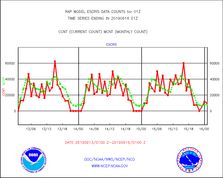
escris |
NPP Crss-track IR Sndr (CrIS) radiances from RARS |
9885 |
7732 |
127.8 % |
1523.00-1602.99 |
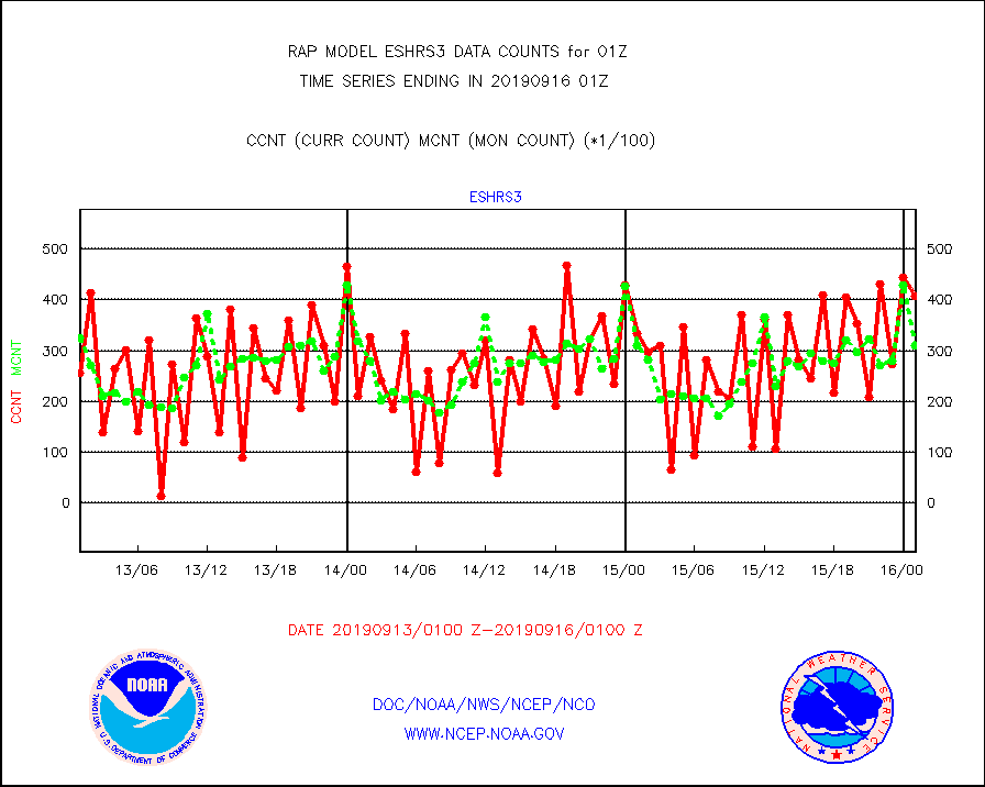
eshrs3 |
NOAA 15-19 & METOP 1-2 HIRS-3/4 pr btmps frm RARS |
40881 |
31012 |
131.8 % |
1600.00-1602.00 |
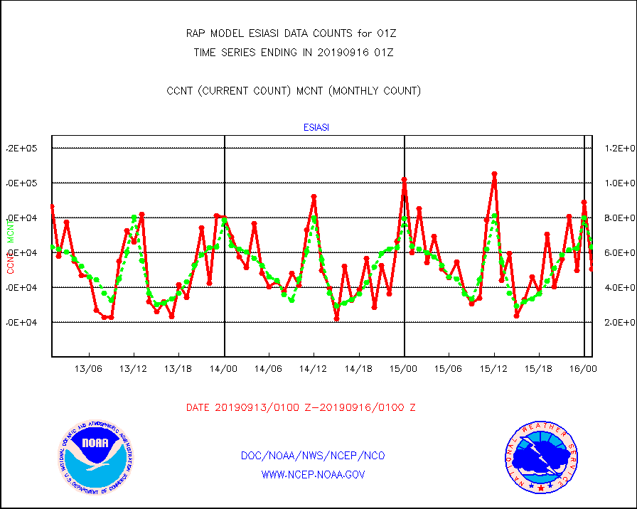
esiasi |
METOP 1-2 IASI 1C radiance data vbl chn from RARS |
50839 |
63295 |
80.3 % |
1523.00-1602.99 |
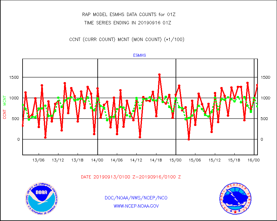
esmhs |
NOAA 18-19 & METOP 1-2 MHS proc. btemps from RARS |
131461 |
79857 |
164.6 % |
1600.00-1602.00 |
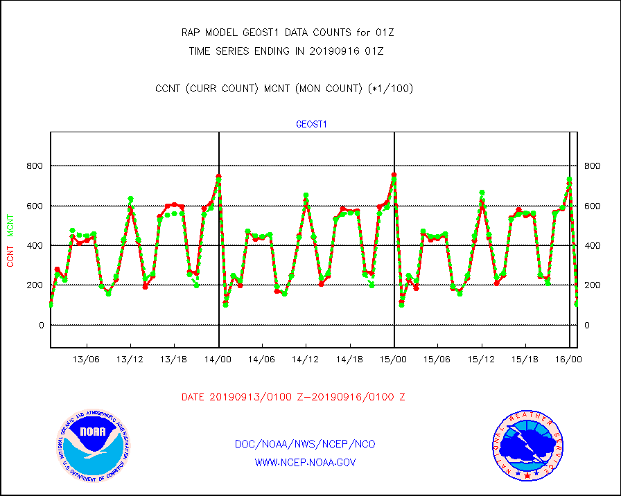
geost1 |
GOES/NESDIS hi-resol. (1x1 f-o-v) sndgs/radiances |
11018 |
10222 |
107.8 % |
1600.00-1602.00 |
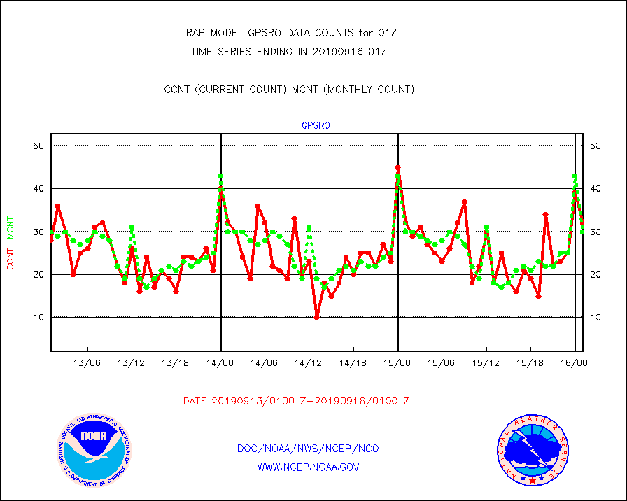
gpsro |
GPS radio occultation data |
32 |
30 |
106.7 % |
1523.00-1602.99 |
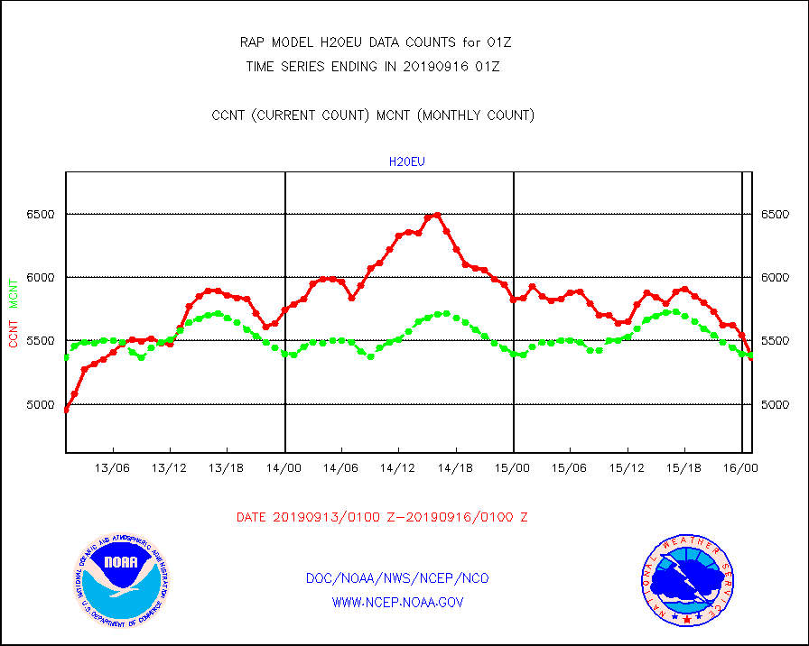
h20eu |
METEOSAT/EUMETSAT wvpr imager derived cld motion |
5368 |
5389 |
99.6 % |
1523.50-1602.49 |
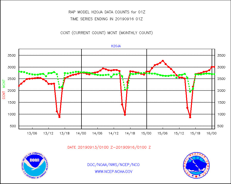
h20ja |
MTSAT/JMA water vapor imager derived cloud motion |
3004 |
2702 |
111.2 % |
1522.50-1603.50 |
iasidb |
METOP 1-2 IASI 1C radiances-direct broadcast SSEC |
7560 |
23283 |
32.5 % |
1523.00-1602.99 |
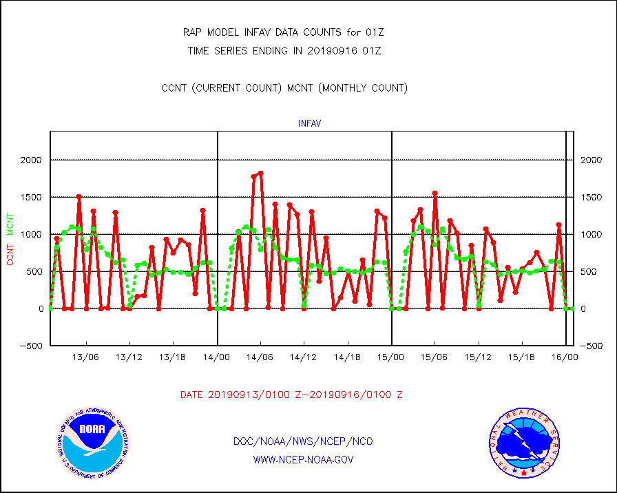
infav |
AVHRR (NOAA/METOP) ir lg-wave derived cld motion |
0 |
0 |
n/a |
1522.50-1603.50 |
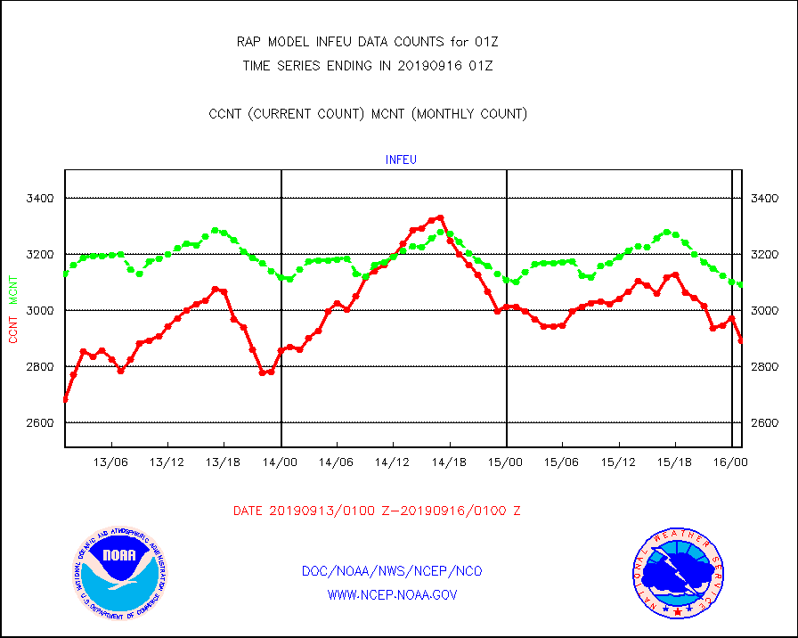
infeu |
METEOSAT/EUMETSAT ir lg-wave derived cloud motion |
2893 |
3093 |
93.5 % |
1523.50-1602.49 |
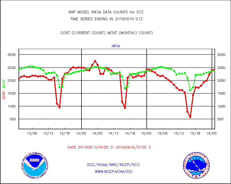
infja |
MTSAT/JMA infrared long-wave derived cloud motion |
2403 |
2369 |
101.4 % |
1522.50-1603.50 |
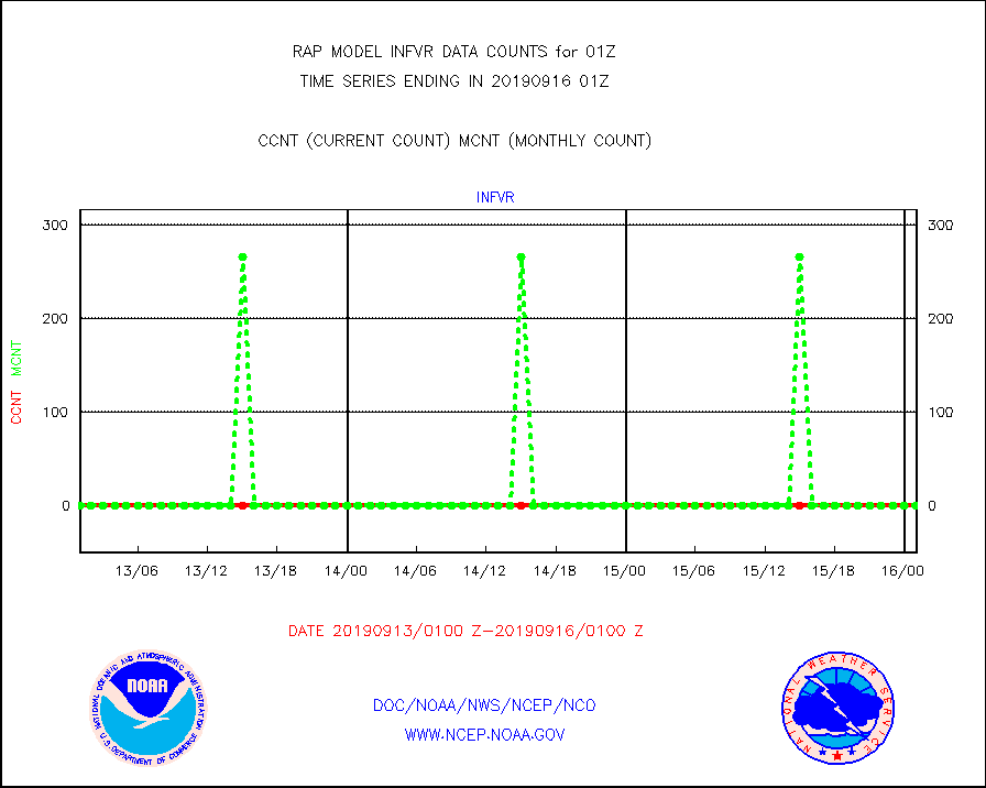
infvr |
VIIRS (NPP) infrared lg-wave derived cloud motion |
0 |
0 |
n/a |
1522.50-1603.50 |
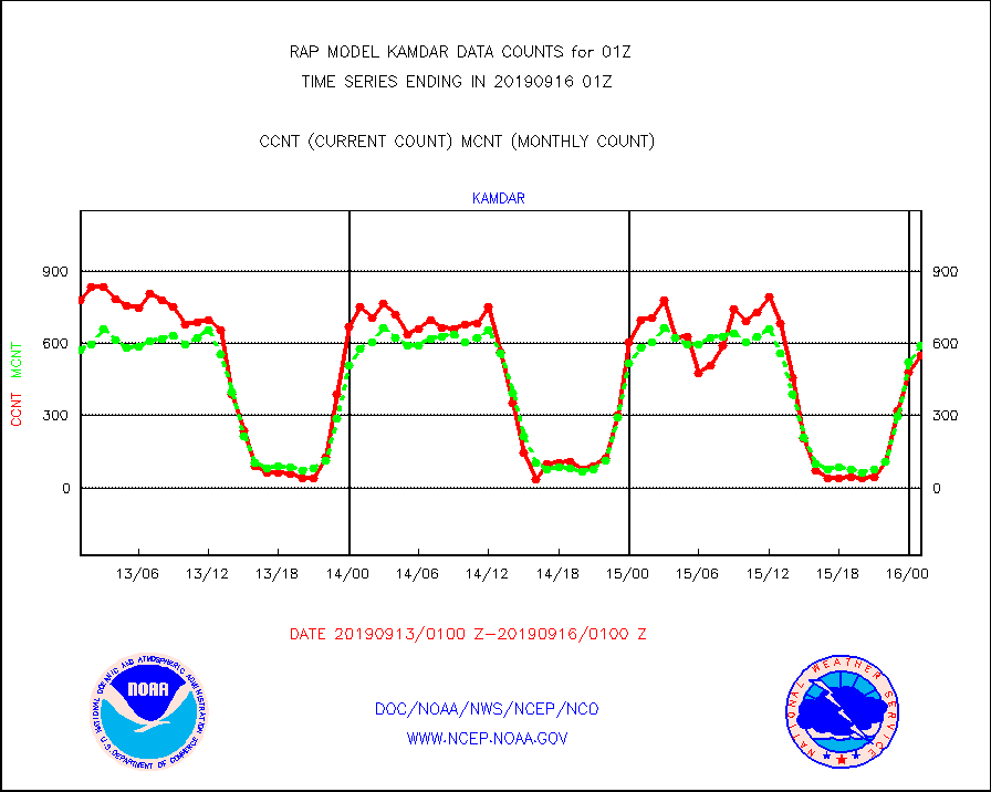
kamdar |
Korean AMDAR aircraft data (decoded from BUFR) |
548 |
590 |
92.9 % |
1521.75-1604.25 |
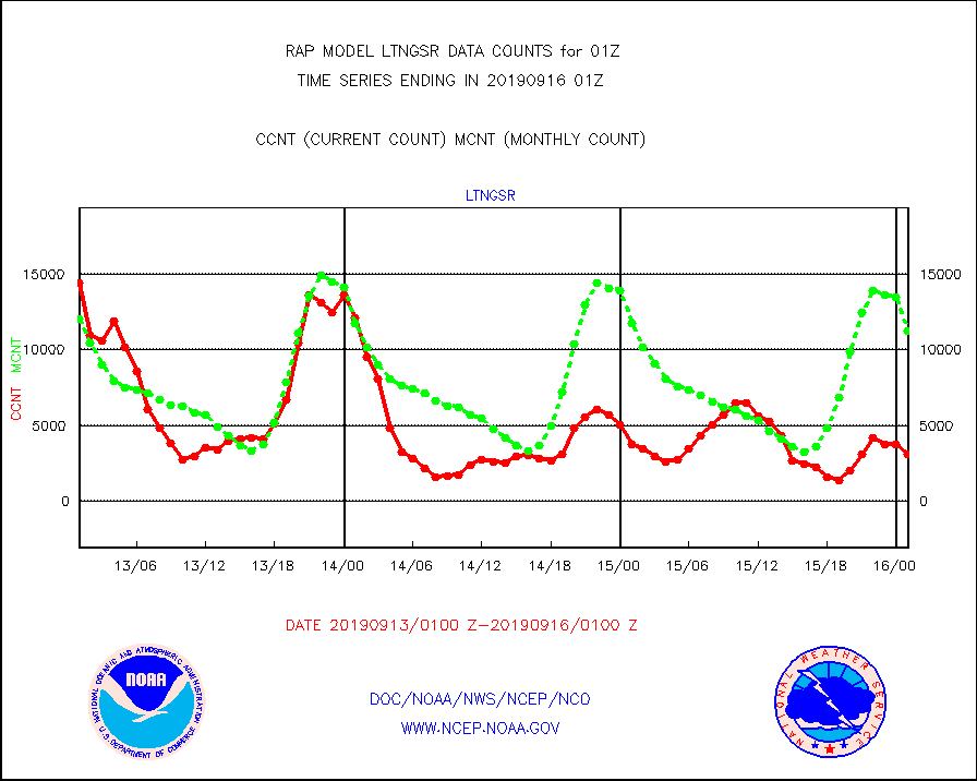
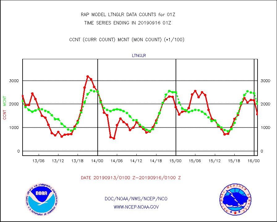
ltnglr |
LLDN Long-rng lightning from Vaisala via NOAAPORT |
156648 |
202500 |
77.4 % |
1600.00-1601.50 |
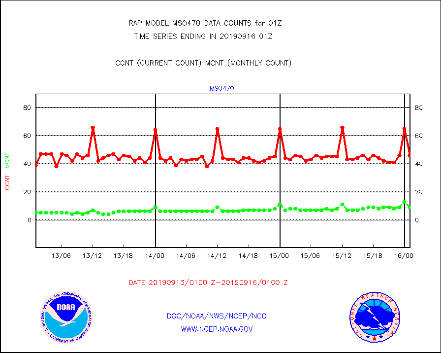
mso470 |
Mesonet/MADIS Colorado E-470 (Interstate 470) |
46 |
9 |
511.1 % |
1600.50-1601.50 |
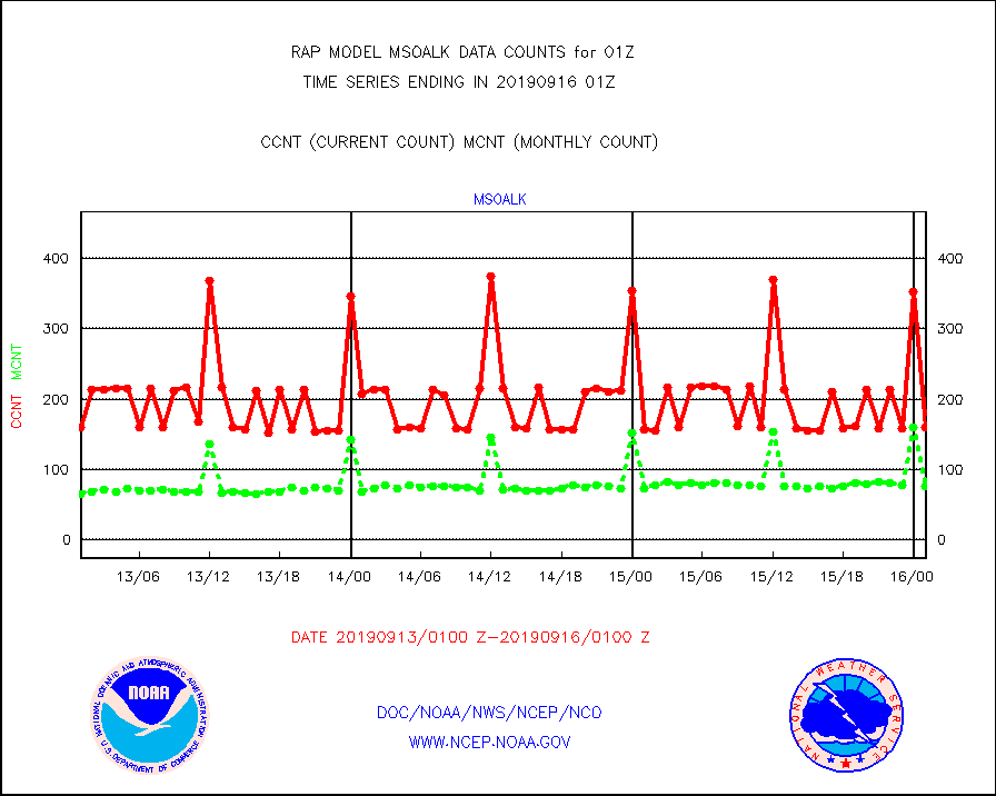
msoalk |
Mesonet/MADIS Alaska Department of Transportation |
160 |
76 |
210.5 % |
1600.50-1601.50 |
msoapg |
Mesonet/MADIS U.S. Army Aberdeen Proving Grounds |
0 |
0 |
n/a |
1600.50-1601.50 |
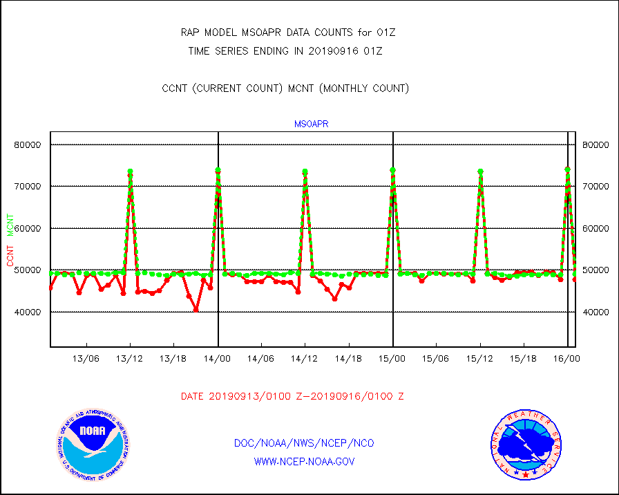
msoapr |
Mesonet/MADIS Citizen Weather Observers Program |
47753 |
49065 |
97.3 % |
1600.50-1601.50 |
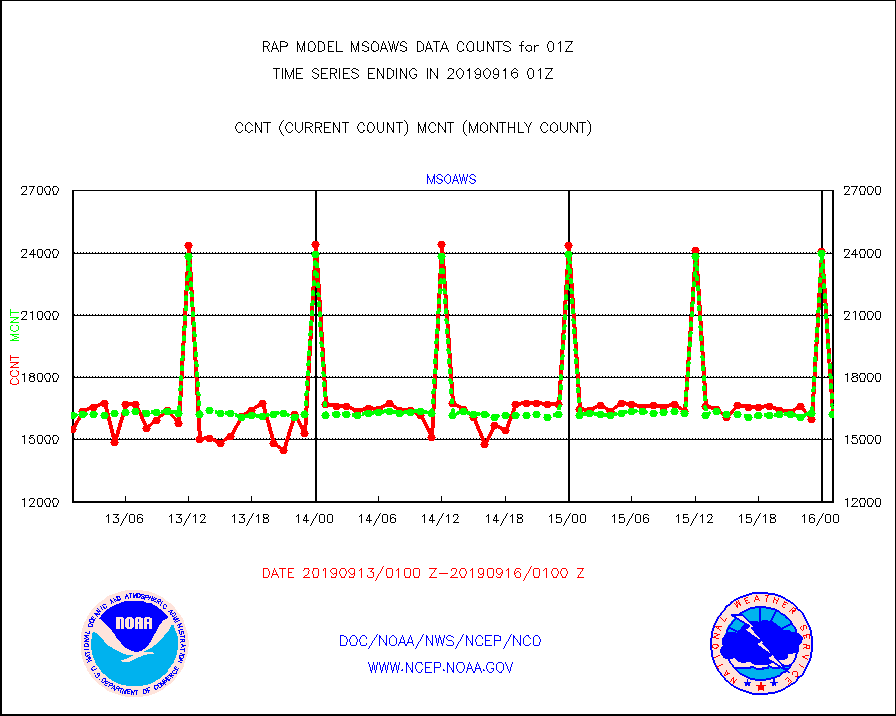
msoaws |
Mesonet/MADIS AWS Convergence Technologies, Inc. |
16240 |
16198 |
100.3 % |
1600.50-1601.50 |
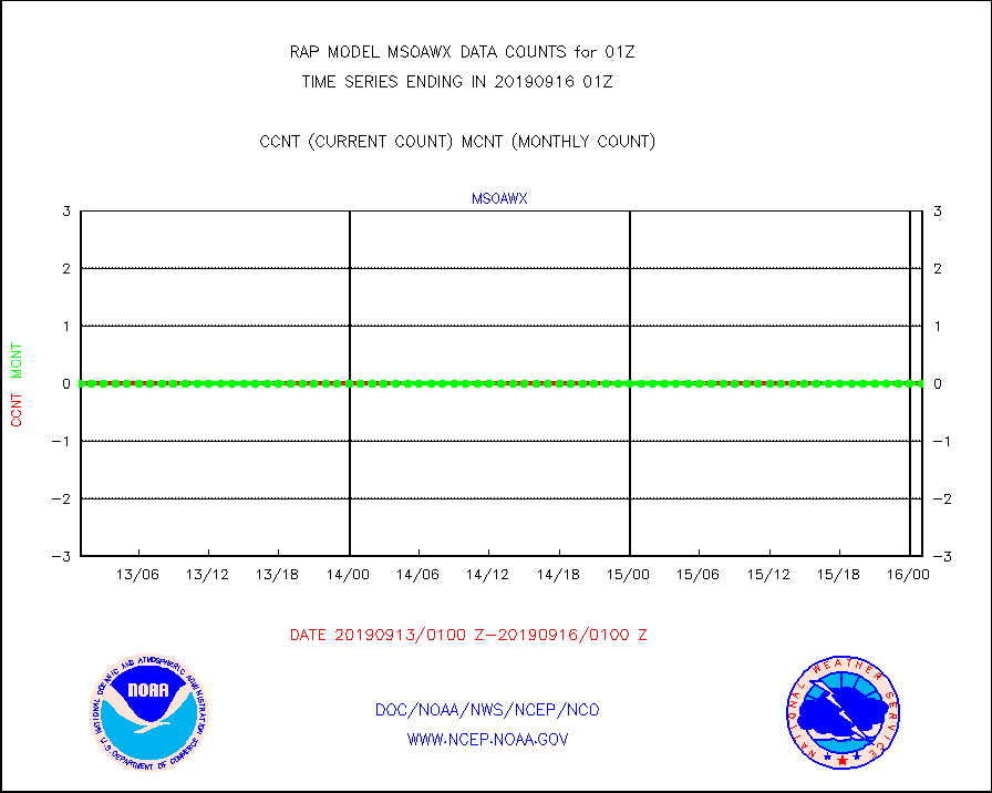
msoawx |
Mesonet/MADIS "Anything Weather" |
0 |
0 |
n/a |
1600.50-1601.50 |
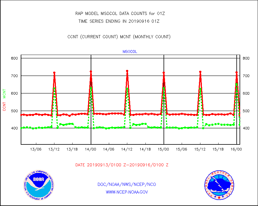
msocol |
Mesonet/MADIS Colorado Dept. of Transportation |
472 |
420 |
112.4 % |
1600.50-1601.50 |
msodcn |
Mesonet/MADIS DC Net |
0 |
0 |
n/a |
1600.50-1601.50 |
msoden |
Mesonet/MADIS Denver Urban Drainage & Flood Cntrl |
0 |
0 |
n/a |
1600.50-1601.50 |
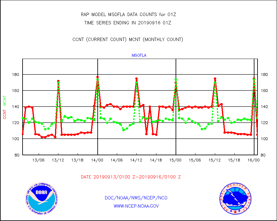
msofla |
Mesonet/MADIS Florida (FAWN & USF) |
105 |
126 |
83.3 % |
1600.50-1601.50 |
msoflt |
Mesonet/MADIS Florida Dept. of Transportation |
0 |
0 |
n/a |
1600.50-1601.50 |
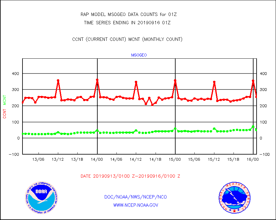
msogeo |
Mesonet/MADIS Georgia Dept. of Transportation |
256 |
50 |
512.0 % |
1600.50-1601.50 |
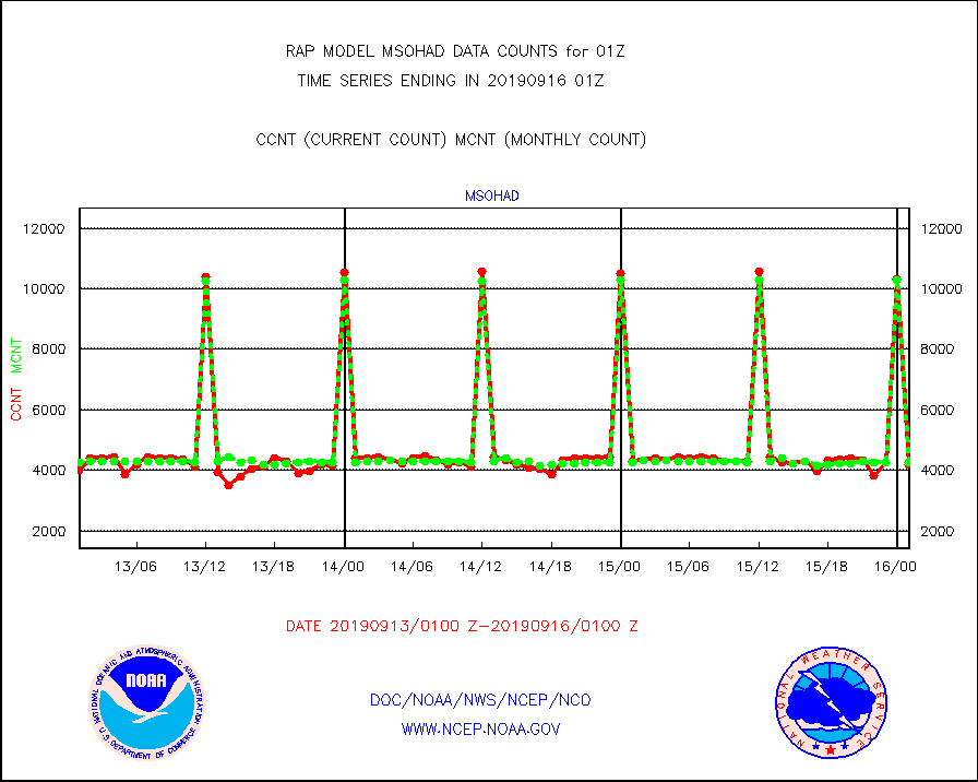
msohad |
Mesonet/MADIS NWS Hydromet Auto Data System(HADS) |
4174 |
4251 |
98.2 % |
1600.50-1601.50 |
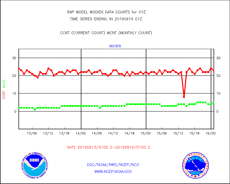
msoien |
Mesonet/MADIS Iowa Environmental |
23 |
5 |
460.0 % |
1600.50-1601.50 |
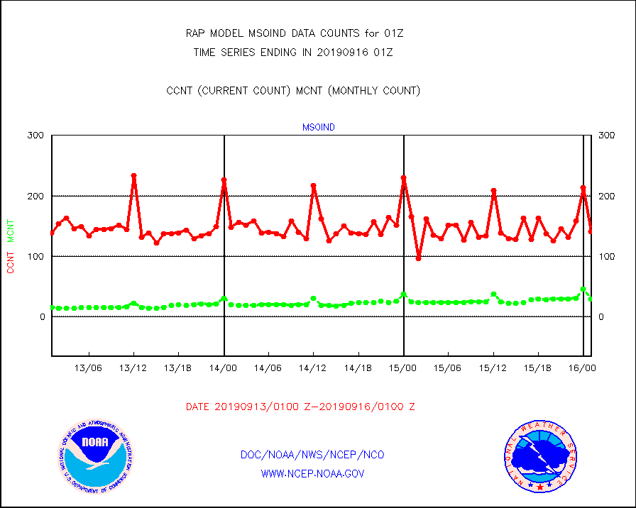
msoind |
Mesonet/MADIS Indiana Dept. of Transportation |
141 |
30 |
470.0 % |
1600.50-1601.50 |
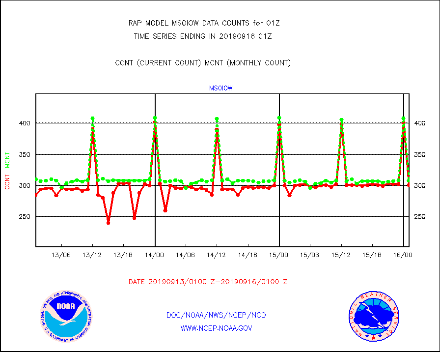
msoiow |
Mesonet/MADIS Iowa Department of Transportation |
301 |
308 |
97.7 % |
1600.50-1601.50 |
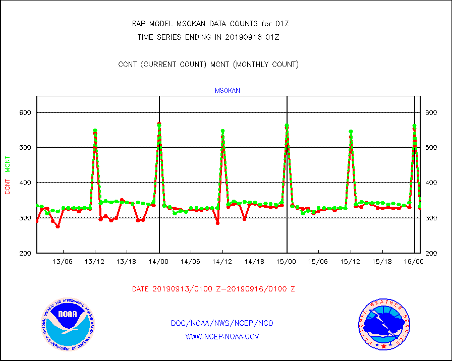
msokan |
Mesonet/MADIS Kansas Department of Transportation |
329 |
333 |
98.8 % |
1600.50-1601.50 |
msokla |
Mesonet/MADIS Oklahoma Mesonet |
321 |
382 |
84.0 % |
1600.50-1601.50 |
msolju |
Mesonet/MADIS Louisiana State/Jackson State Univ. |
0 |
0 |
n/a |
1600.50-1601.50 |
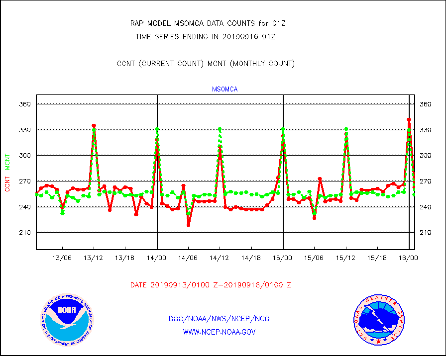
msomca |
Mesonet/MADIS Missouri Commercial Agricult Wx Net |
263 |
254 |
103.5 % |
1600.50-1601.50 |
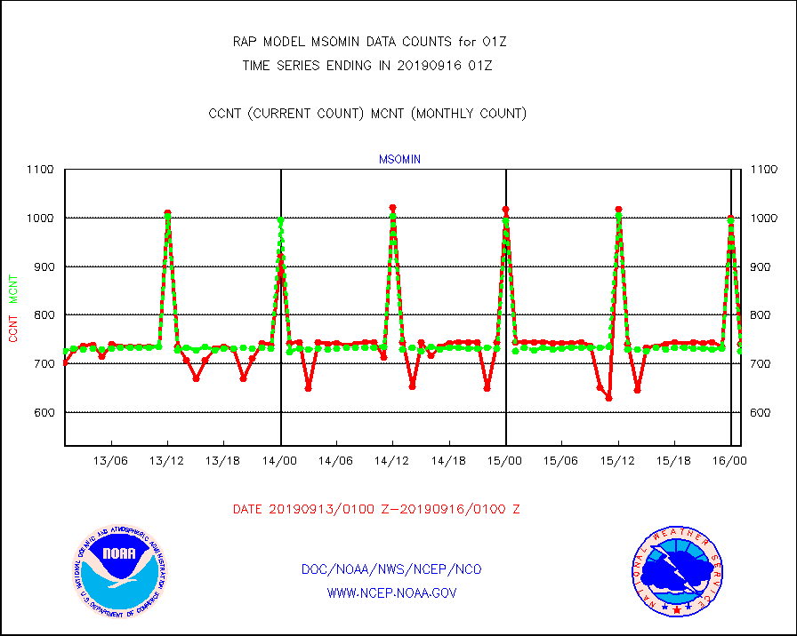
msomin |
Mesonet/MADIS Minnesota Dept. of Transportation |
741 |
726 |
102.1 % |
1600.50-1601.50 |
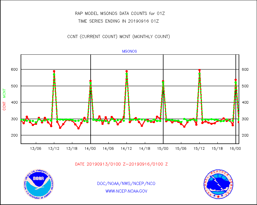
msonos |
Mesonet/MADIS NOS-Phys Oceanographic Realtime Sys |
280 |
295 |
94.9 % |
1600.50-1601.50 |
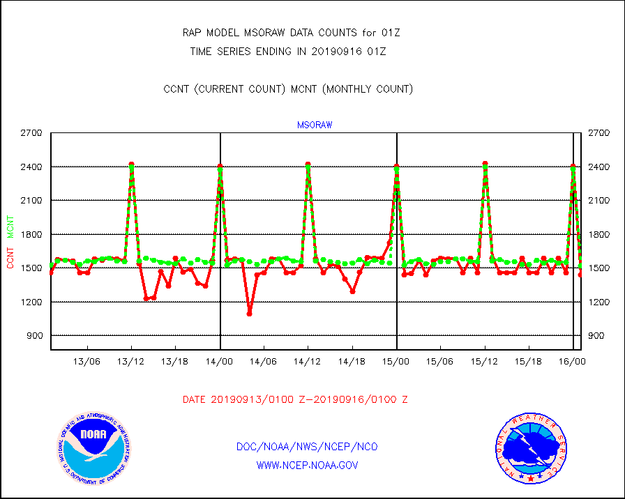
msoraw |
Mesonet/MADIS NFIC Remote Automated Wx Stns(RAWS) |
1440 |
1520 |
94.7 % |
1600.50-1601.50 |
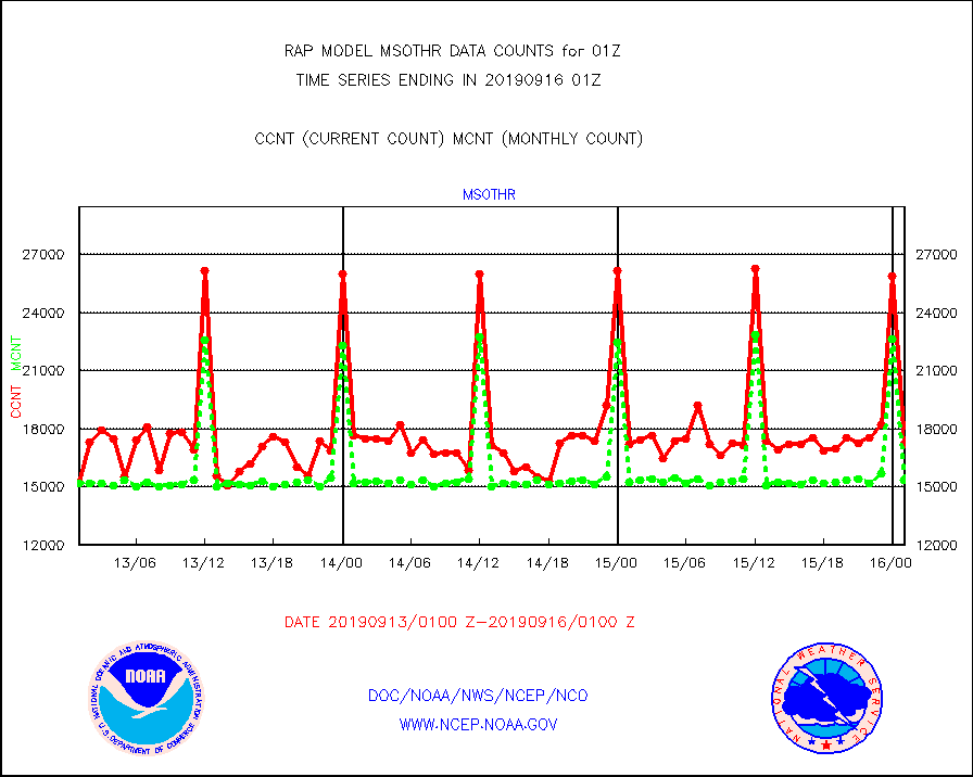
msothr |
Mesonet/MADIS many providers, not separated out |
17171 |
15333 |
112.0 % |
1600.50-1601.50 |
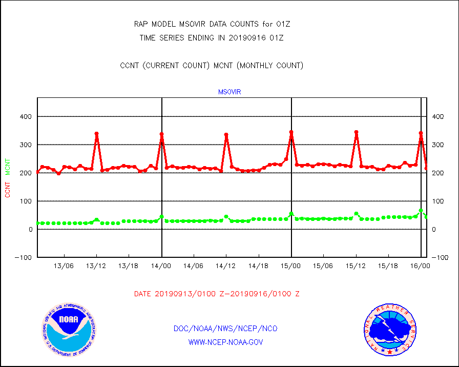
msovir |
Mesonet/MADIS Virginia Dept. of Transportation |
216 |
44 |
490.9 % |
1600.50-1601.50 |
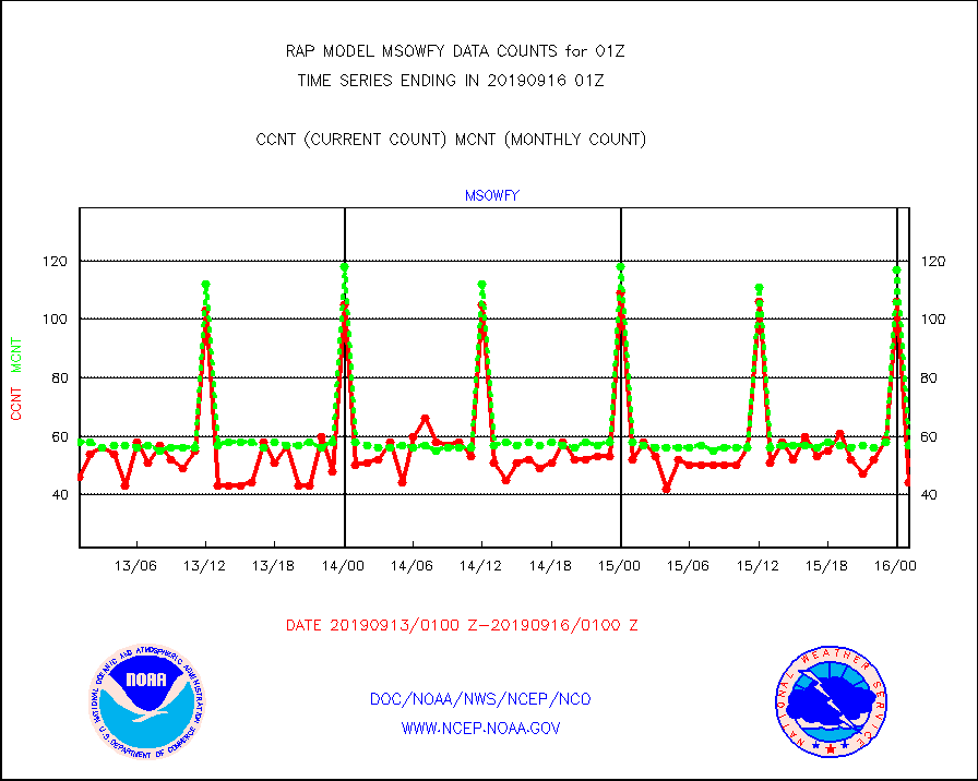
msowfy |
Mesonet/MADIS "Weather for You" |
44 |
57 |
77.2 % |
1600.50-1601.50 |
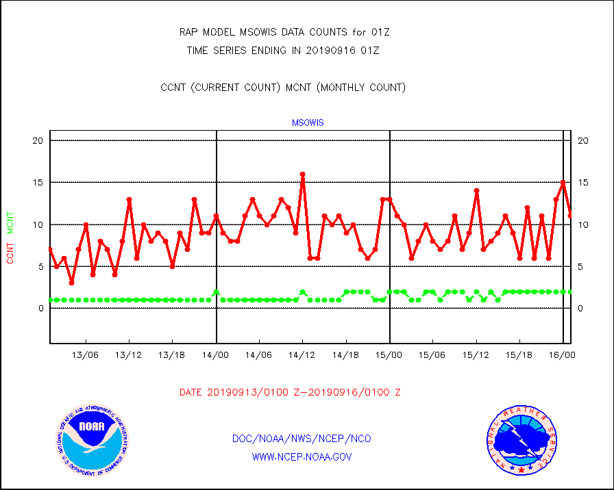
msowis |
Mesonet/MADIS Wisconsin Dept. of Transportation |
11 |
2 |
550.0 % |
1600.50-1601.50 |
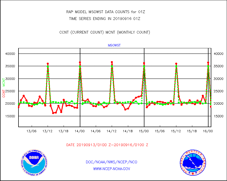
msowst |
Mesonet/MADIS MesoWest (many subproviders) |
18712 |
19733 |
94.8 % |
1600.50-1601.50 |
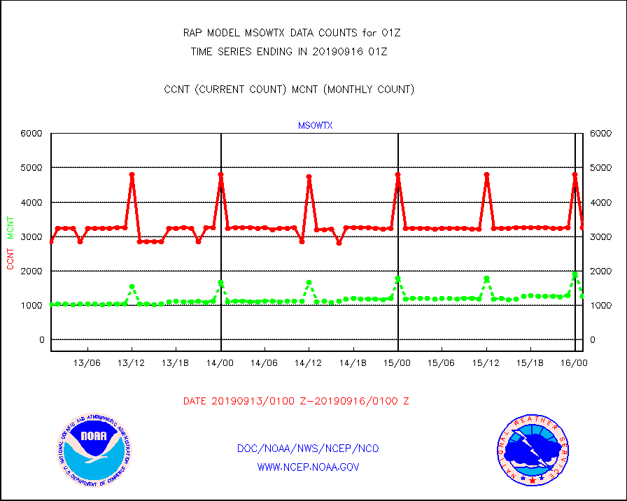
msowtx |
Mesonet/MADIS West Texas |
3251 |
1262 |
257.6 % |
1600.50-1601.50 |
mtiasi |
METOP 1-2 IASI 1C radiance data (varbl. channels) |
44417 |
42241 |
105.2 % |
1523.00-1602.99 |
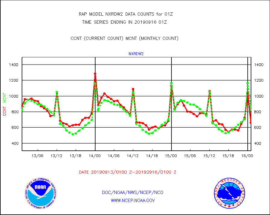
nxrdw2 |
NEXRAD Vel Azm Dsp(VAD) winds via Level 2 decoder |
664 |
826 |
80.4 % |
1600.00-1602.00 |
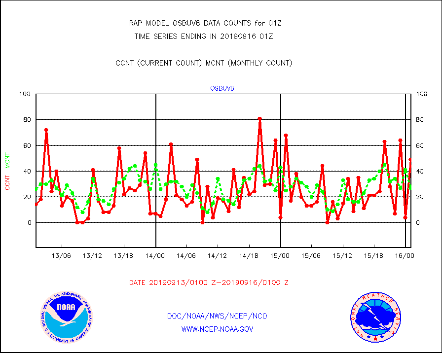
osbuv8 |
NOAA 16-19 Solar Backscatter UV-2 rad frm V8 BUFR |
49 |
27 |
181.5 % |
1523.00-1601.99 |
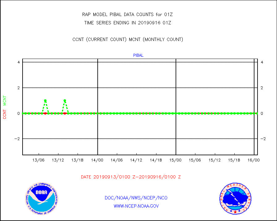
pibal |
PIBAL (from PILOT, PILOT SHIP, PILOT MOBIL) |
0 |
0 |
n/a |
1600.00-1602.00 |
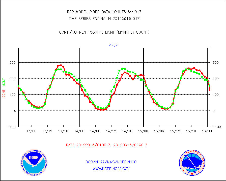
pirep |
Manual PIREP aircraft data (dcded from AIREP fmt) |
130 |
152 |
85.5 % |
1521.75-1604.25 |
prflrp |
Profilr winds from PIBAL (PILOT,PILOT SHIP/MOBIL) |
0 |
0 |
n/a |
1523.50-1602.50 |
radw25 |
NEXRAD radial wind superobs (Level 2.5 - ORPG) |
0 |
0 |
n/a |
1600.00-1602.00 |
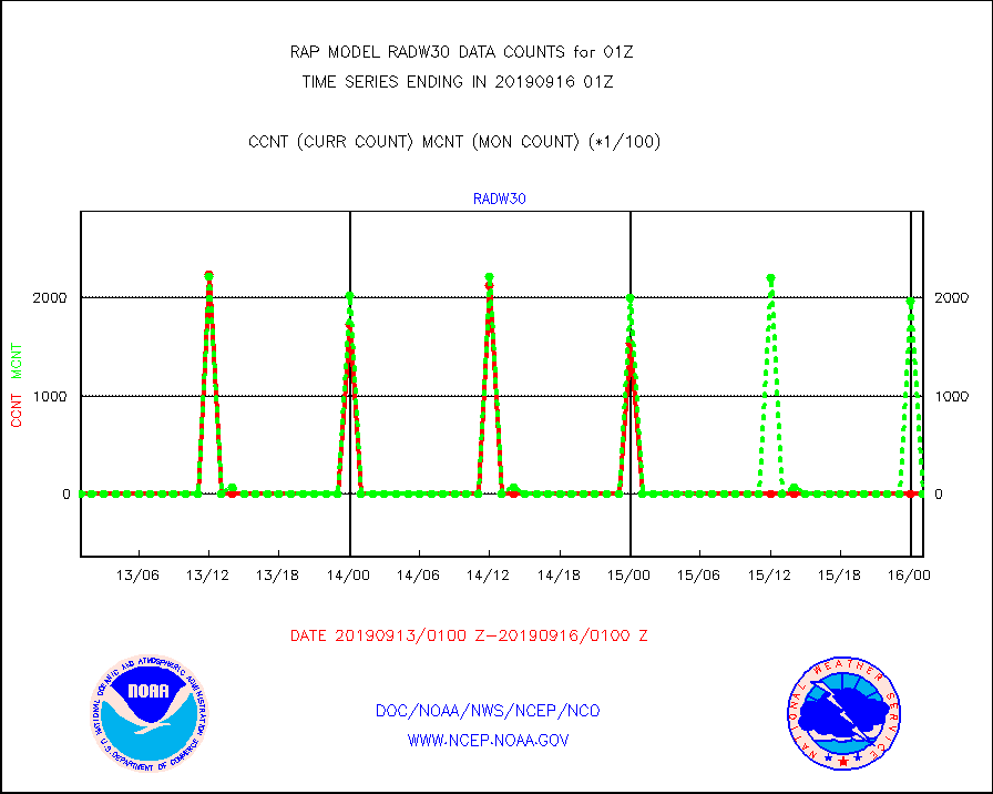
radw30 |
NEXRAD radial wind superobs (Level 3 - NIDS) |
0 |
0 |
n/a |
1600.00-1602.00 |
raobm |
Rawinsonde - mobile land (from TEMP/PILOT MOBIL) |
0 |
0 |
n/a |
1600.00-1602.00 |
raobs |
Rawinsonde - ship (from TEMP SHIP, PILOT SHIP) |
2 |
1 |
200.0 % |
1600.00-1602.00 |
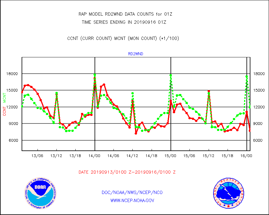
rd2wnd |
NEXRAD radial wind (Level 2 - GTS) |
772051 |
1196615 |
64.5 % |
1600.50-1601.49 |
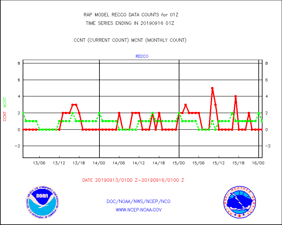
recco |
Flight level reconnaissance aircraft data |
0 |
1 |
0.0 % |
1600.00-1602.00 |
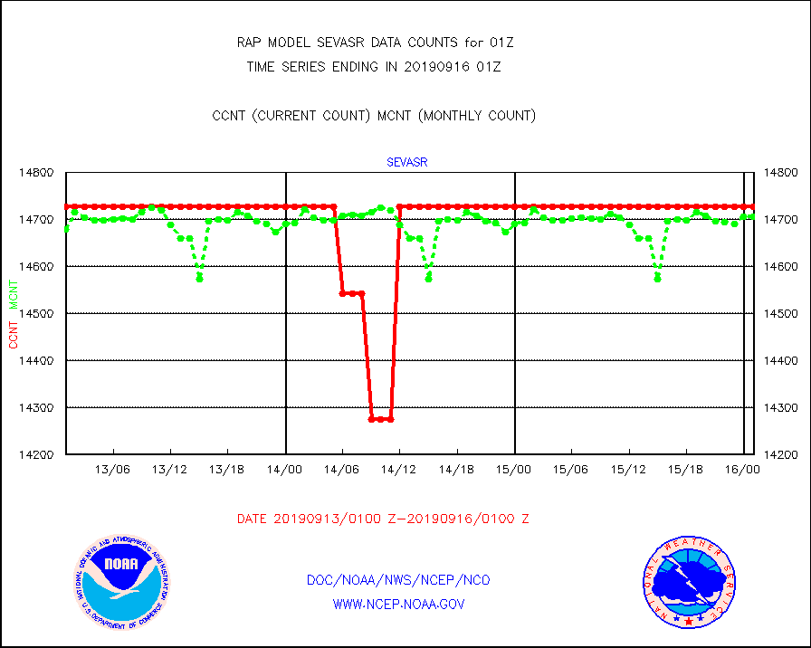
sevasr |
METEOSAT-10 2nd Gen SEVIRI All Sky Radiance(proc) |
14727 |
14707 |
100.1 % |
1523.00-1602.99 |
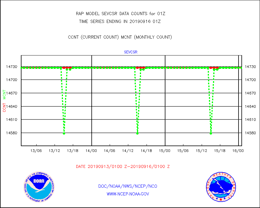
sevcsr |
METEOSAT-10 2nd Gen SEVIRI Clr Sky Radiance(proc) |
14727 |
14727 |
100.0 % |
1523.00-1602.99 |
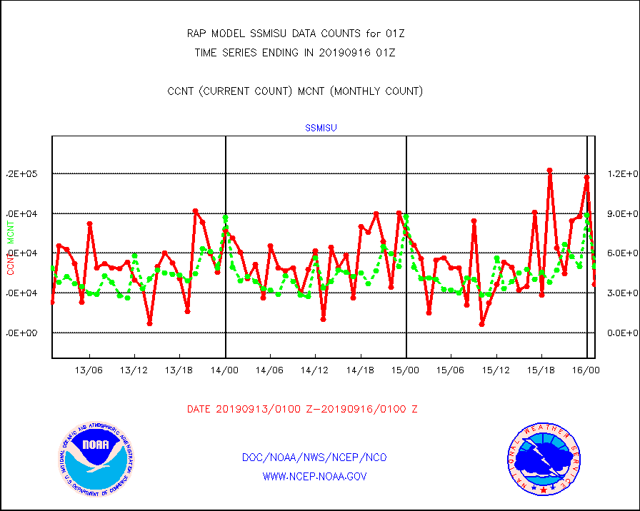
ssmisu |
DMSP SSM/IS 1C radiance data (Unified Pre-Proc.) |
36535 |
49745 |
73.4 % |
1523.00-1602.99 |
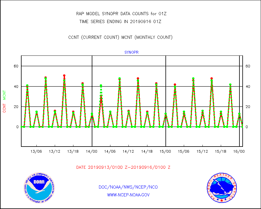
synopr |
Synoptic - restricted (WMO Res 40) manual & auto. |
0 |
0 |
n/a |
1600.50-1601.50 |
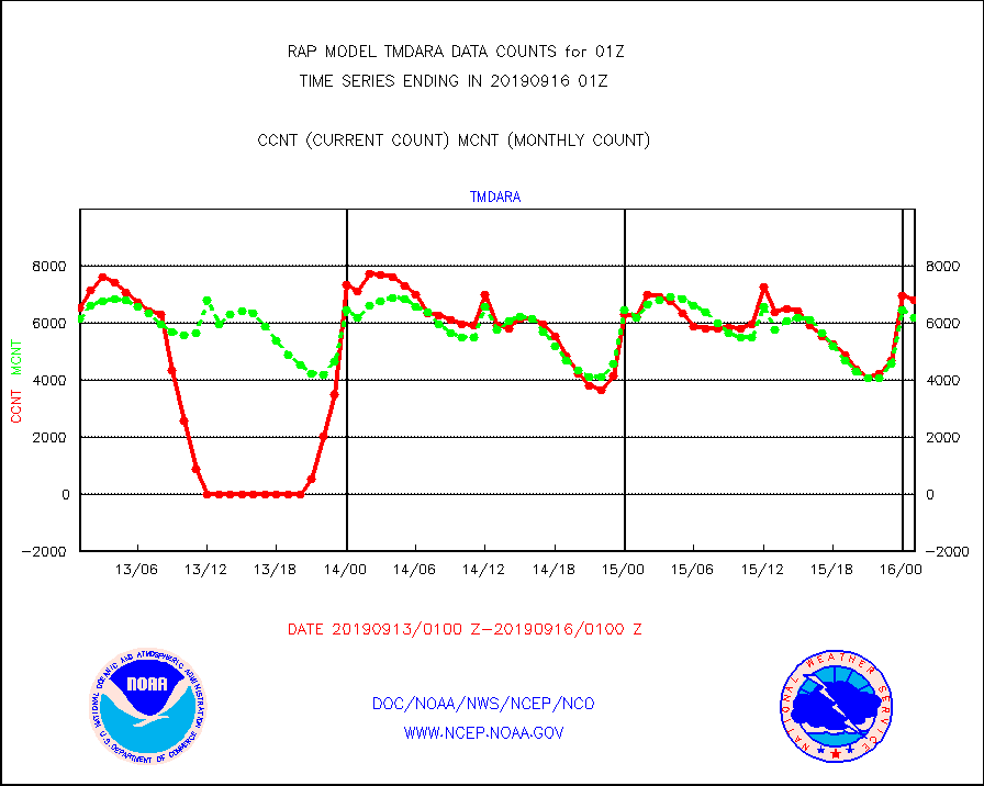
tmdara |
TAMDAR aircft data-all types(from Panasonic,BUFR) |
6814 |
6194 |
110.0 % |
1521.75-1604.25 |
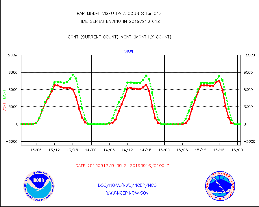
viseu |
METEOSAT/EUMETSAT visible derived cloud motion |
0 |
0 |
n/a |
1523.50-1602.49 |
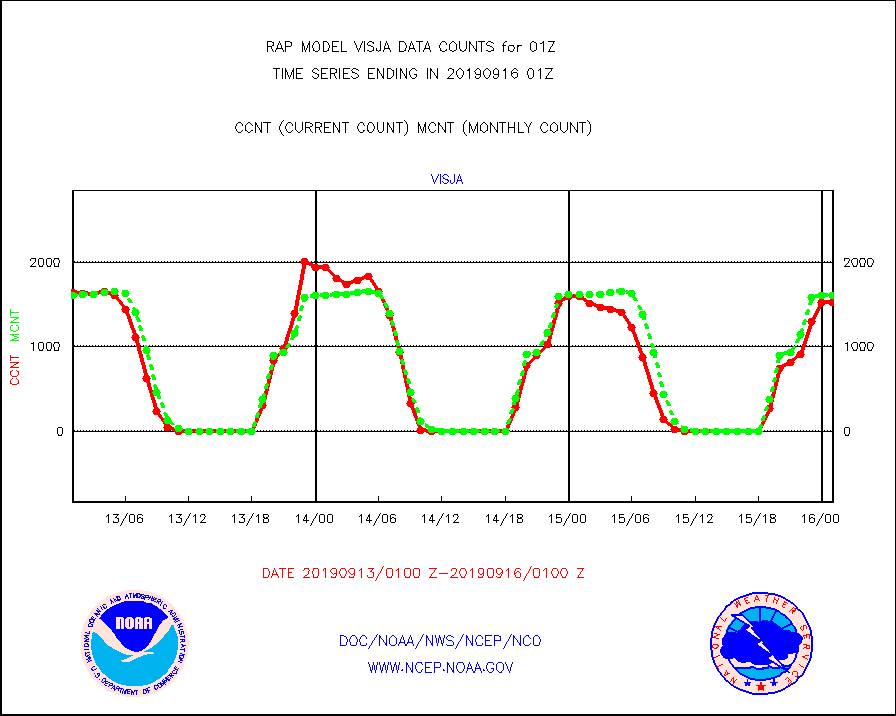
visja |
MTSAT/JMA visible derived cloud motion |
1526 |
1614 |
94.5 % |
1522.50-1603.50 |
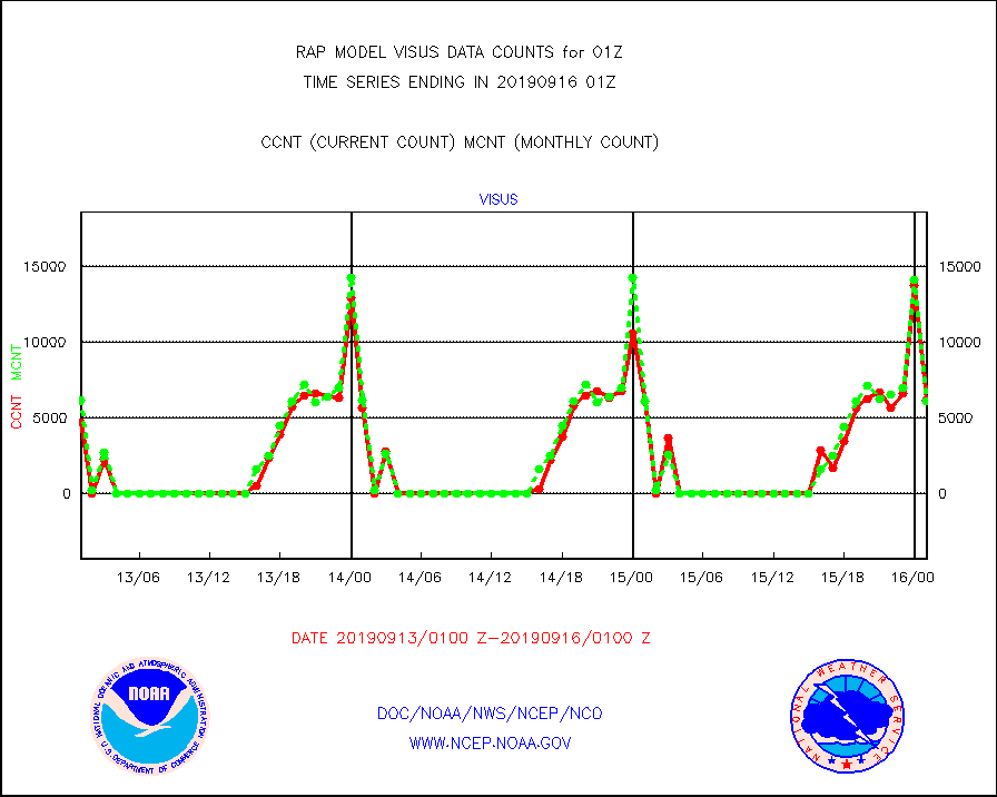
visus |
GOES/NESDIS visible derived cloud motion |
6216 |
6136 |
101.3 % |
1600.00-1600.99 |


