| Critical Data with Normal Counts |
|---|
| Type | Description | Hourly Count | Monthly Average | Percent (%) of Monthly Mean | UTC Time Window |
1bamua |
NOAA 15-19 & METOP 1-2 AMSU-A NCEP-proc. br.temps |
19523 |
22817 |
85.6 % |
1607.00-1612.99 |
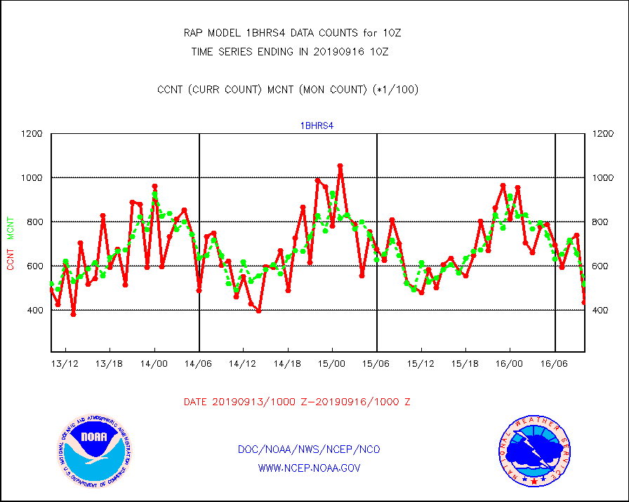
1bhrs4 |
NOAA 18-19 & METOP 1-2 HIRS-4 NCEP-proc. br.temps |
43346 |
51731 |
83.8 % |
1607.00-1612.99 |
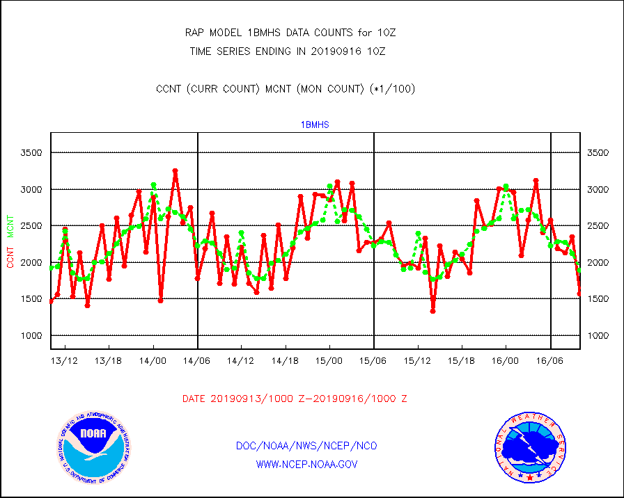
1bmhs |
NOAA 18-19 & METOP 1-2 MHS NCEP-proces. br. temps |
157197 |
189721 |
82.9 % |
1607.00-1612.99 |
acars |
MDCRS ACARS acft data from ARINC(dcded from BUFR) |
13671 |
4417 |
309.5 % |
1606.75-1613.25 |
camdar |
Canadian AMDAR aircraft data (decoded from BUFR) |
106 |
74 |
143.2 % |
1606.75-1613.25 |
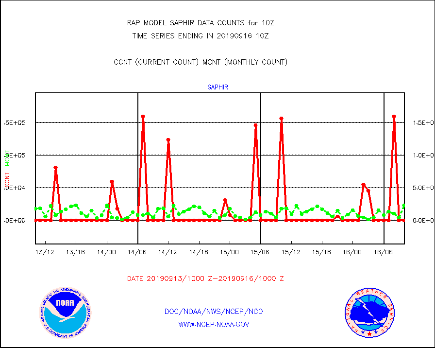
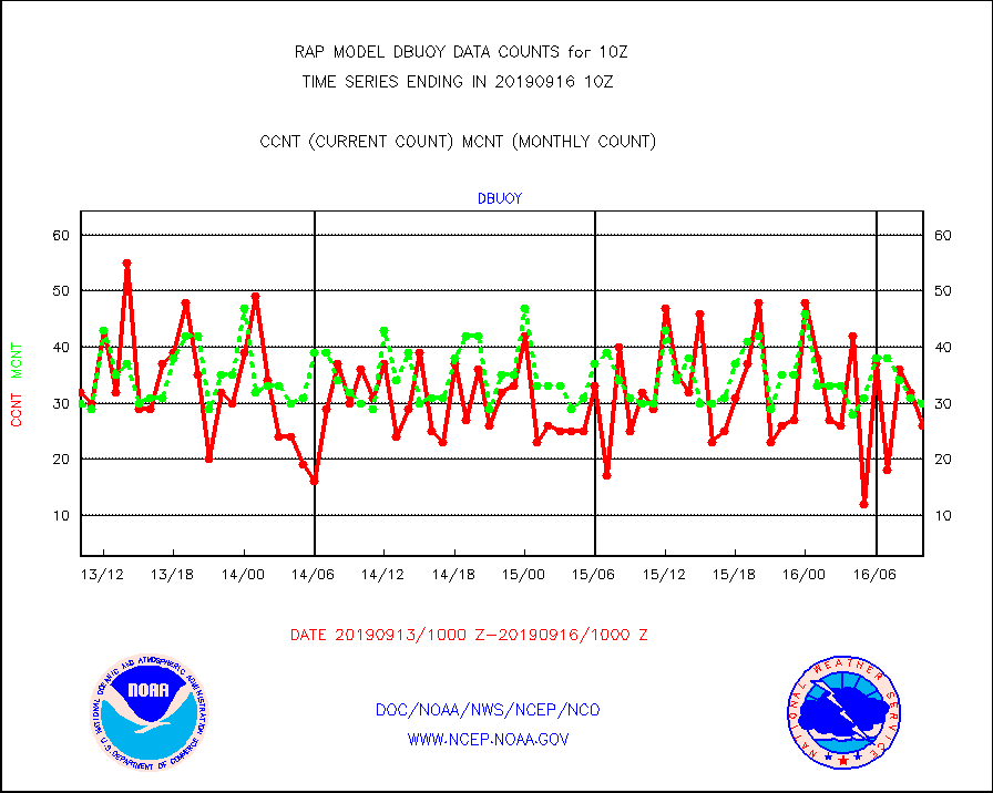
dbuoy |
Buoys decoded from FM-18 fmt (moored or drifting) |
26 |
30 |
86.7 % |
1609.50-1610.50 |
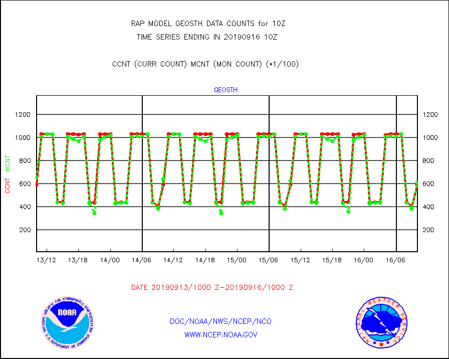
geosth |
GOES/NESDIS hi-resol. (1x1 f-o-v) cloud data |
59103 |
60995 |
96.9 % |
1608.75-1609.99 |
gnss |
Grnd-based Gbl Navigation Sat System (GNSS) data |
2583 |
2500 |
103.3 % |
1608.95-1609.05 |
h20mo |
MODIS (AQUA/TERRA) wvpr imager derived cld motion |
0 |
0 |
n/a |
1607.50-1612.50 |
h2ius |
GOES/NESDIS water vapor imager derived cld motion |
3211 |
1744 |
184.1 % |
1609.00-1609.99 |
infmo |
MODIS (AQUA/TERRA) ir l-wave derived cloud motion |
0 |
0 |
n/a |
1607.50-1612.50 |
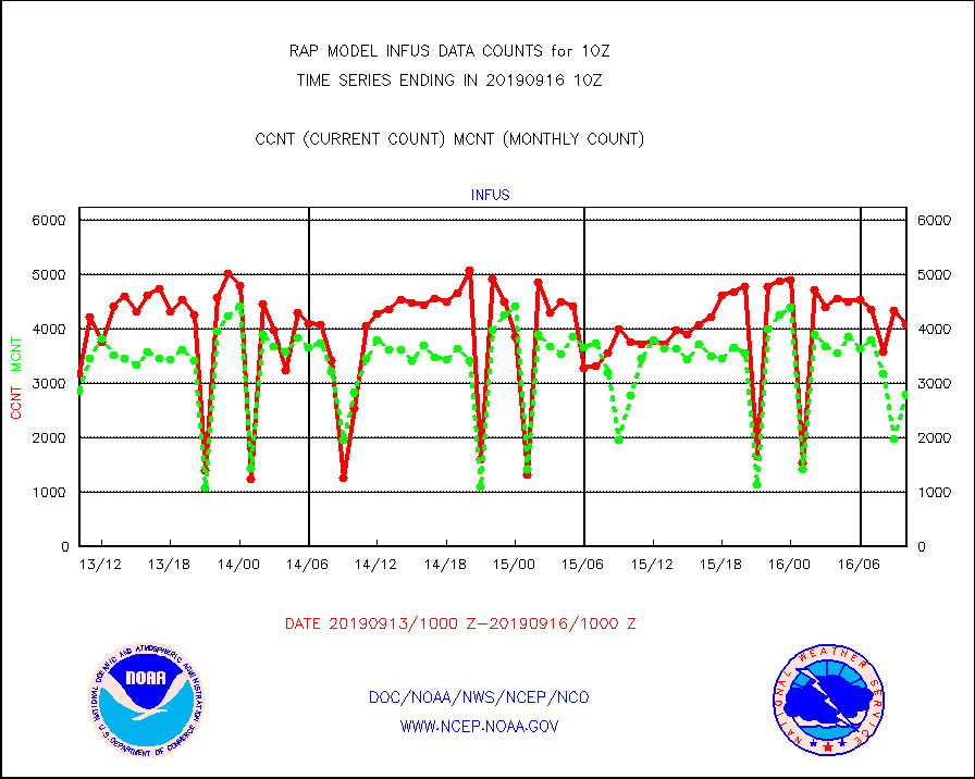
infus |
GOES/NESDIS infrared lg-wave derived cloud motion |
4089 |
2795 |
146.3 % |
1609.00-1609.99 |
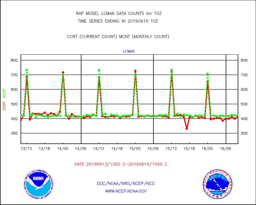
lcman |
Land-based CMAN stations decoded from CMAN format |
414 |
425 |
97.4 % |
1609.50-1610.50 |
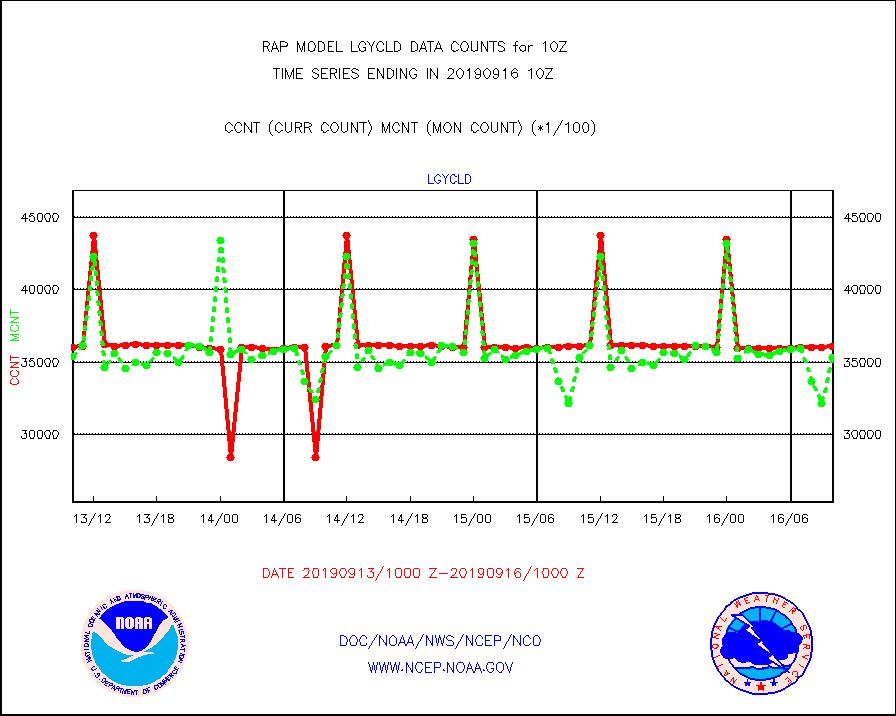
lgycld |
GOES/NASA(Langley) hi-res. (1x1 f-o-v) cloud data |
3609347 |
3535957 |
102.1 % |
1609.50-1610.50 |
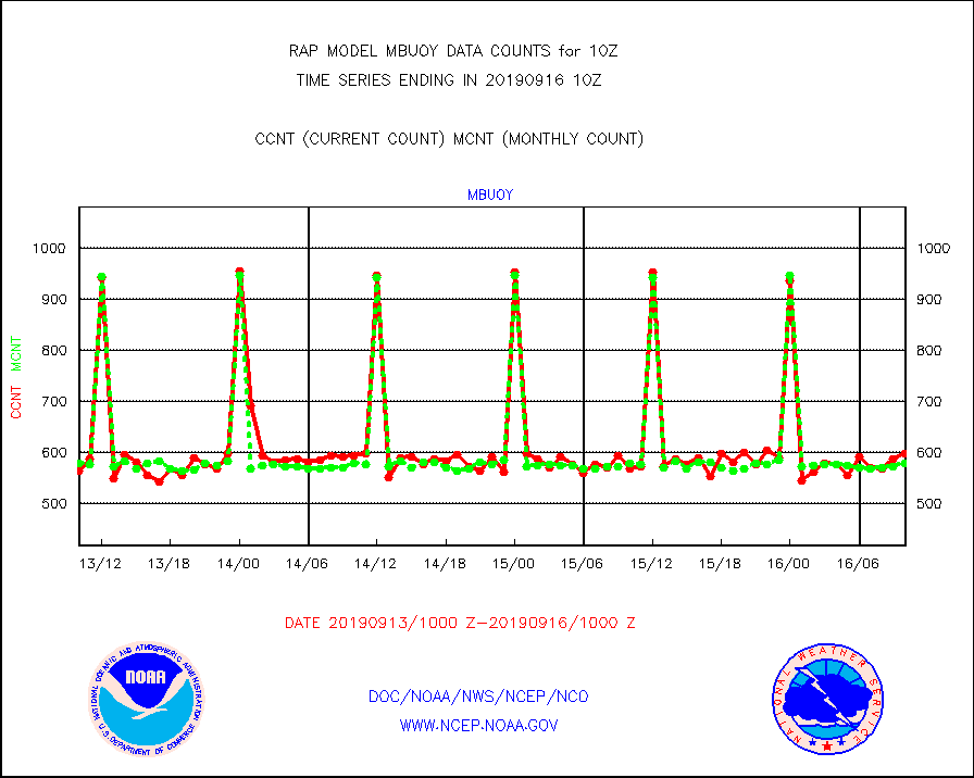
mbuoy |
Buoys decoded from FM-13 format (moored) |
599 |
579 |
103.5 % |
1609.50-1610.50 |
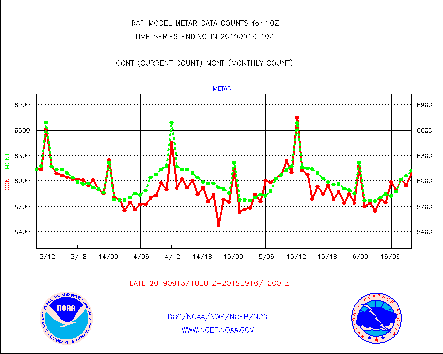
metar |
Aviation - METAR |
6098 |
6130 |
99.5 % |
1609.50-1610.50 |
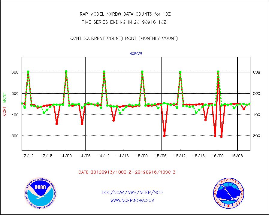
nxrdw |
NEXRAD Vel Azm Dsp(VAD) winds via radar coded msg |
449 |
452 |
99.3 % |
1609.00-1611.00 |
prflrb |
Multi-Agency Profiler (MAP) and SODAR winds |
109 |
132 |
82.6 % |
1608.50-1611.50 |
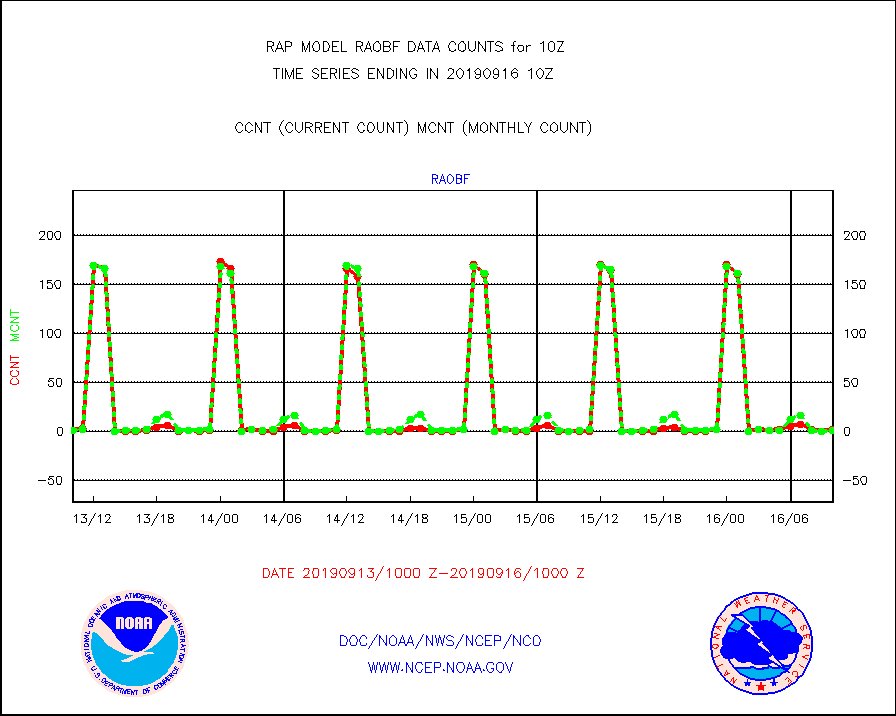
raobf |
Rawinsonde - fixed land (from TEMP or PILOT) |
2 |
1 |
200.0 % |
1609.00-1611.00 |
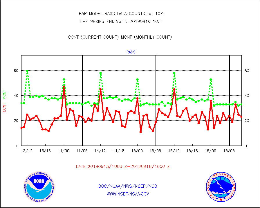
rass |
RASS temperatures (NOAA and Multi-Agency) |
23 |
33 |
69.7 % |
1609.50-1610.50 |
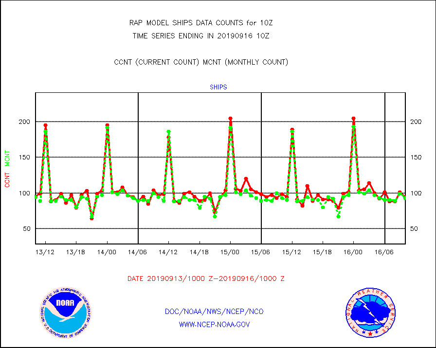
ships |
Ship - manual and automatic, restricted |
94 |
93 |
101.1 % |
1609.50-1610.50 |
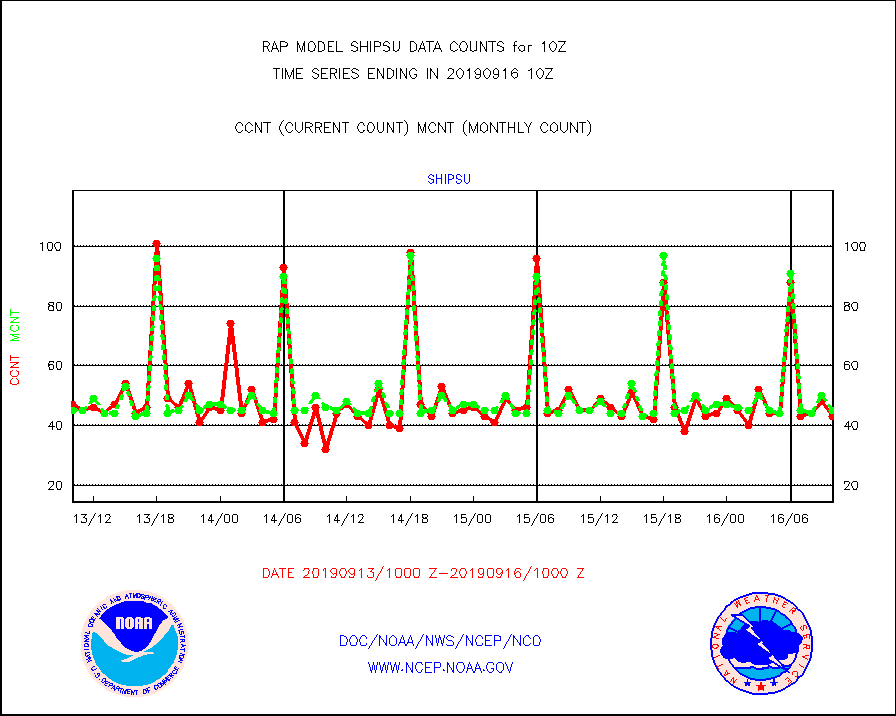
shipsu |
Ship - manual and automatic, unrestricted |
43 |
45 |
95.6 % |
1609.50-1610.50 |
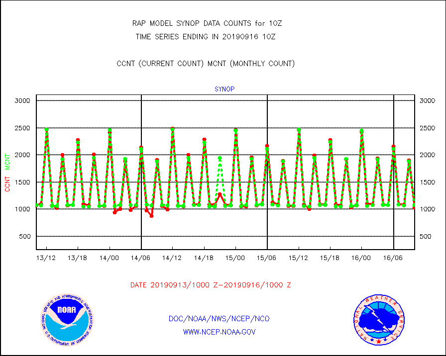
synop |
Synoptic - fixed manual and automatic |
1031 |
1076 |
95.8 % |
1609.50-1610.50 |
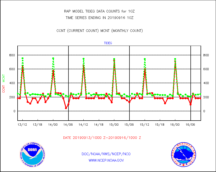
tideg |
Tide gauge reports decoded from CREX format |
184 |
244 |
75.4 % |
1609.50-1610.50 |
| Data Types of Opportunity with Normal Counts |
|---|
| Type | Description | Hourly Count | Monthly Average | Percent (%) of Monthly Mean | UTC Time Window |
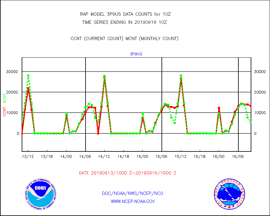
3p9us |
GOES/NESDIS infrared shrt-wave derived cld motion |
13218 |
5213 |
253.6 % |
1609.00-1609.99 |
acarsa |
MDCRS ACARS acft data (ARINC via AFWA)(AIREP fmt) |
0 |
0 |
n/a |
1606.75-1613.25 |
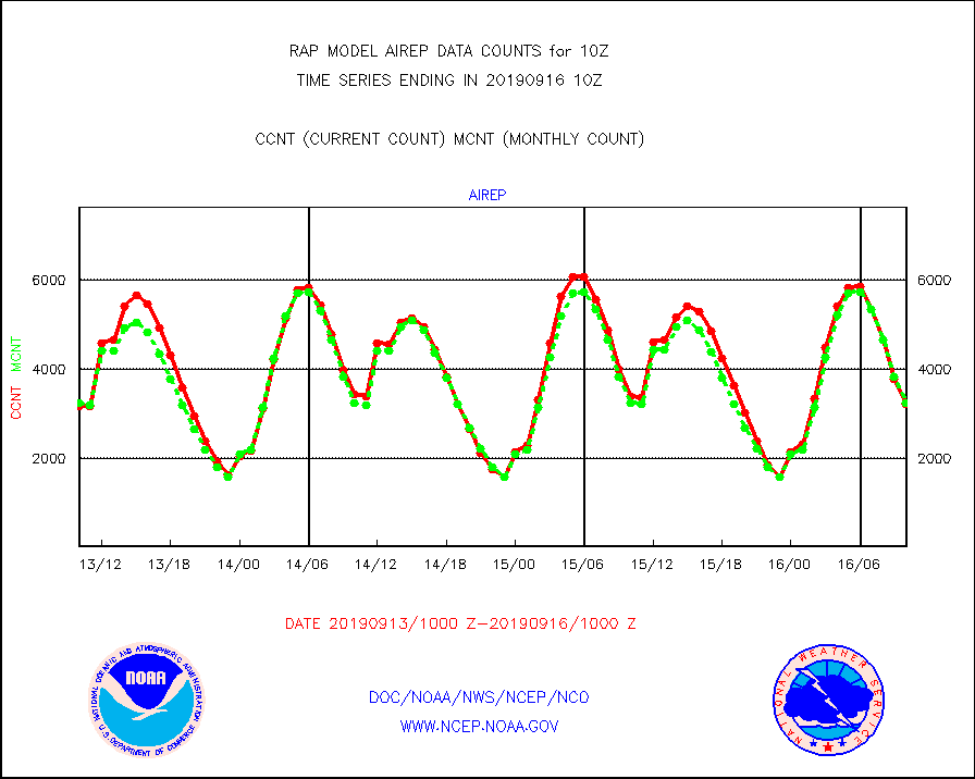
airep |
Manual AIREP aircraft data (dcded from AIREP fmt) |
3215 |
3242 |
99.2 % |
1606.75-1613.25 |
airsev |
AQUA AIRS/AMSU-A/HSB brightness temps- every FOV |
12150 |
26816 |
45.3 % |
1607.00-1612.99 |
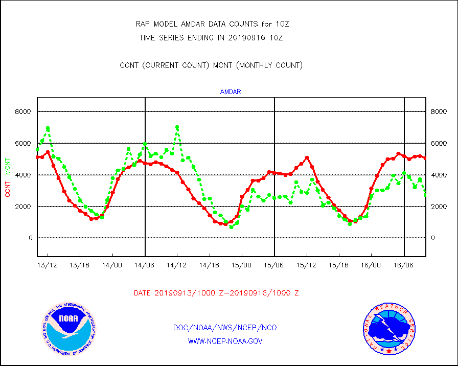
amdar |
AMDAR aircraft data (decoded from AMDAR format) |
5043 |
2726 |
185.0 % |
1606.75-1613.25 |
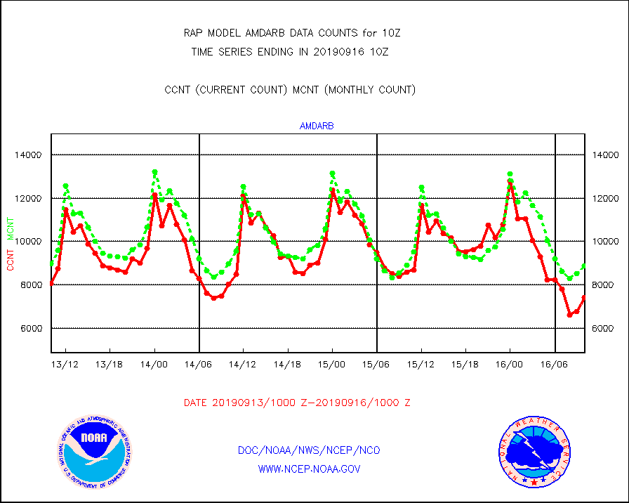
amdarb |
AMDAR aircraft data (decoded from BUFR) |
7419 |
8879 |
83.6 % |
1606.75-1613.25 |
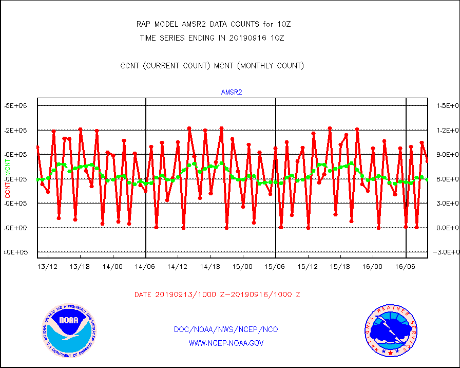
amsr2 |
GCOM-W AMSR2 1B brightness temperatures |
818205 |
594105 |
137.7 % |
1607.00-1607.99 |
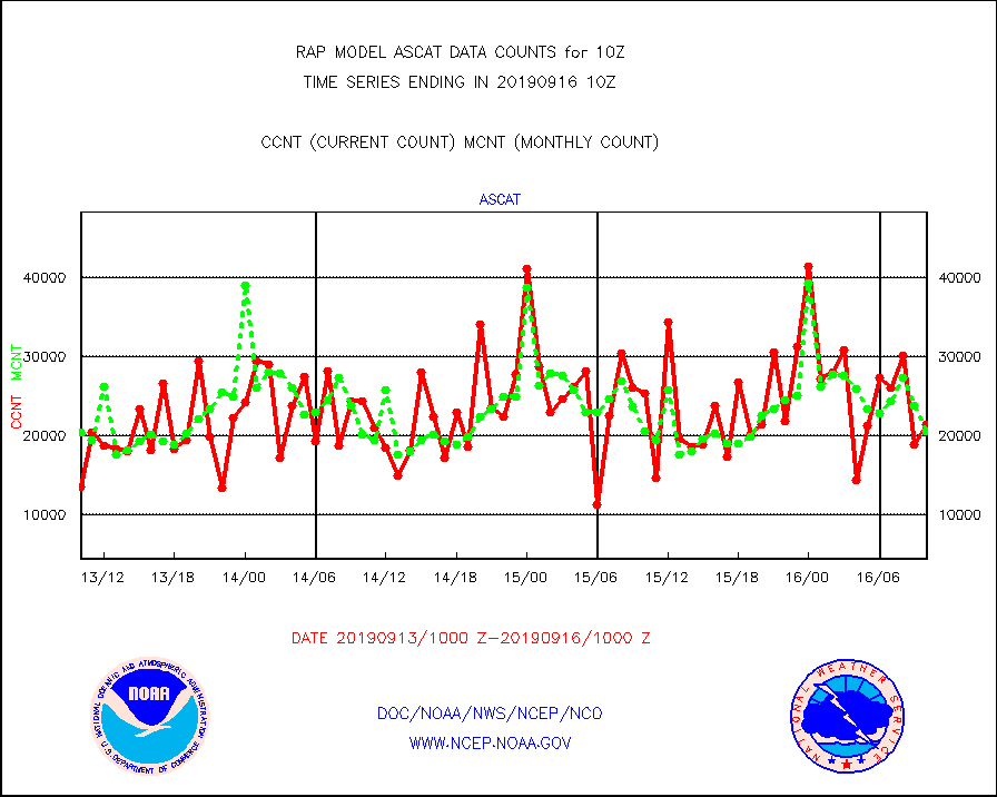
ascat |
METOP 1-2 ASCAT products |
21435 |
20533 |
104.4 % |
1608.00-1612.00 |
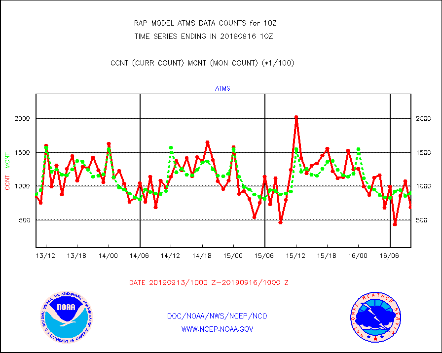
atms |
NPP Adv. Tech. Microwave Sounder (ATMS) br. temps |
69112 |
89729 |
77.0 % |
1608.00-1611.99 |
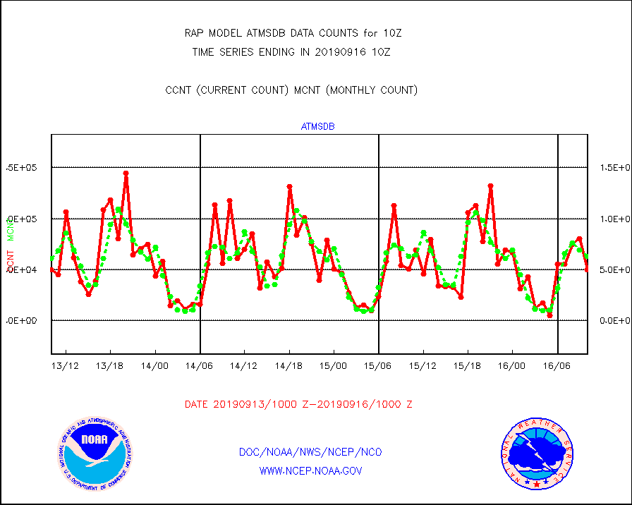
atmsdb |
NPP Adv Tech MW Sndr(ATMS) b. temps-dir bcst SSEC |
49540 |
62954 |
78.7 % |
1608.00-1611.99 |
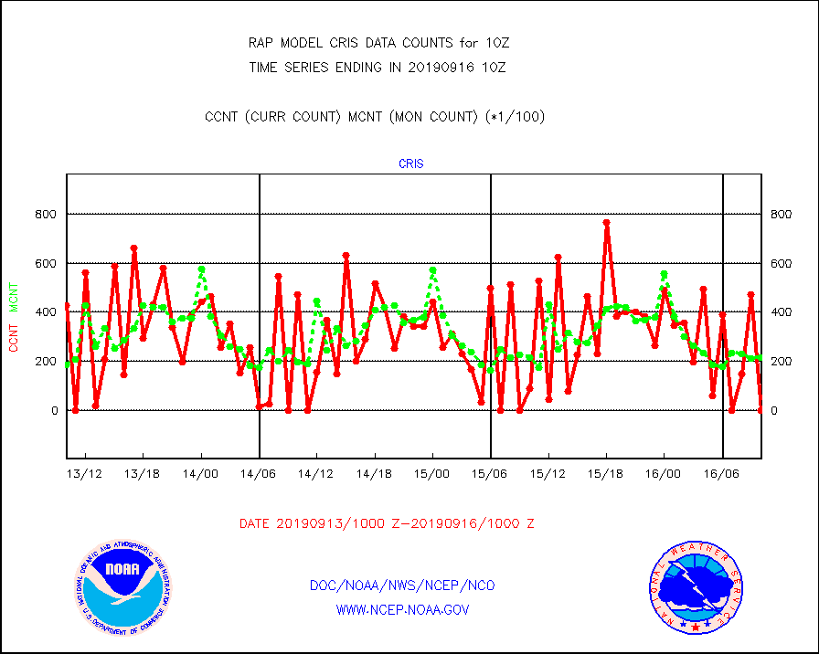
cris |
NPP Cross-track Infrared Sounder (CrIS) radiances |
0 |
21872 |
0.0 % |
1608.00-1611.99 |
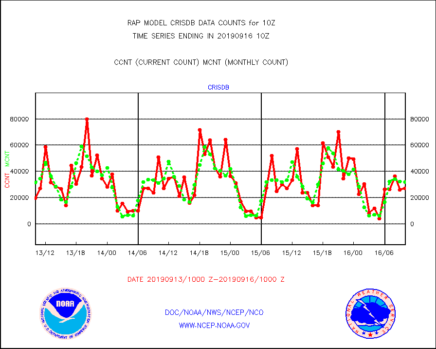
crisdb |
NPP Crss-trk IR Sndr(CrIS) radiance-dir bcst SSEC |
26834 |
31905 |
84.1 % |
1608.00-1611.99 |
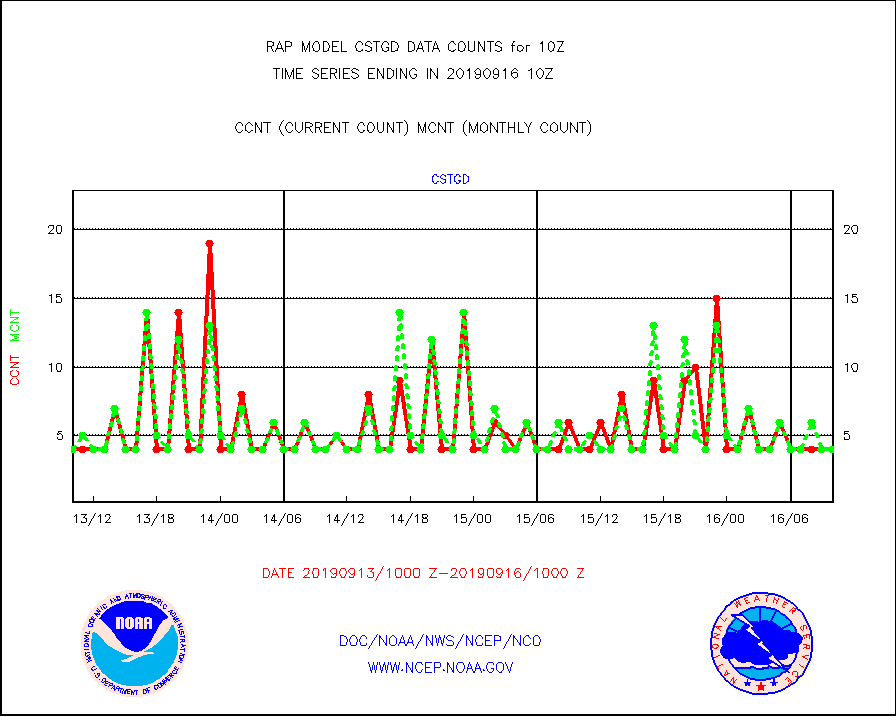
cstgd |
Coast Guard |
4 |
4 |
100.0 % |
1609.50-1610.50 |
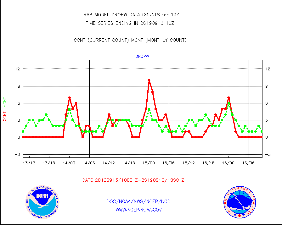
dropw |
Dropwinsonde (from TEMP DROP) |
0 |
1 |
0.0 % |
1609.00-1611.00 |
eadas |
E-AMDAR (European AMDAR acft decoded from BUFR) |
10023 |
9161 |
109.4 % |
1606.75-1613.25 |
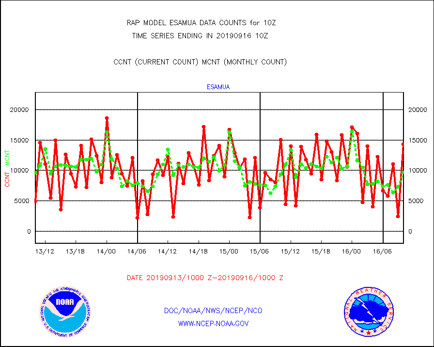
esamua |
NOAA 15-19 & METOP 1-2 AMSU-A proc btmps frm RARS |
14305 |
9688 |
147.7 % |
1609.00-1611.00 |
esatms |
NPP Adv. Tech. MW Sndr (ATMS) br. temps from RARS |
74571 |
61447 |
121.4 % |
1608.00-1611.99 |
escris |
NPP Crss-track IR Sndr (CrIS) radiances from RARS |
20711 |
25864 |
80.1 % |
1608.00-1611.99 |
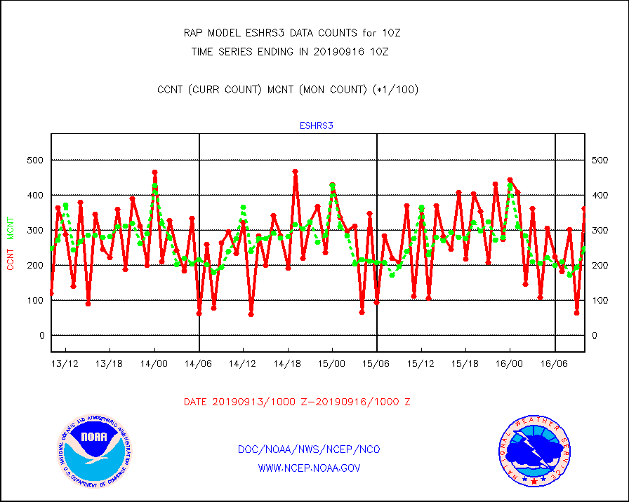
eshrs3 |
NOAA 15-19 & METOP 1-2 HIRS-3/4 pr btmps frm RARS |
36334 |
24718 |
147.0 % |
1609.00-1611.00 |
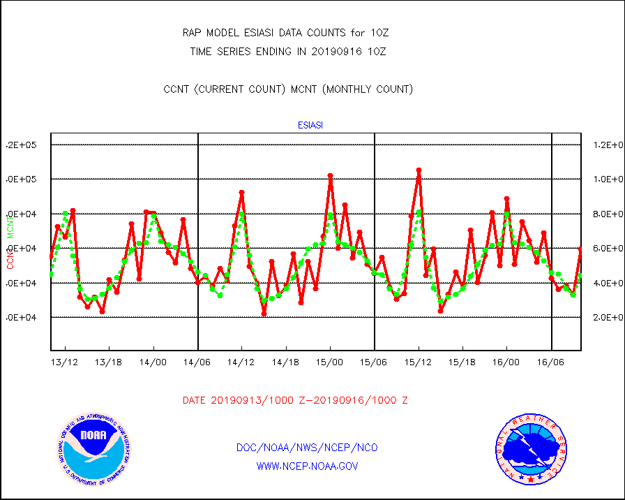
esiasi |
METOP 1-2 IASI 1C radiance data vbl chn from RARS |
59696 |
44376 |
134.5 % |
1608.00-1611.99 |
esmhs |
NOAA 18-19 & METOP 1-2 MHS proc. btemps from RARS |
82892 |
57025 |
145.4 % |
1609.00-1611.00 |
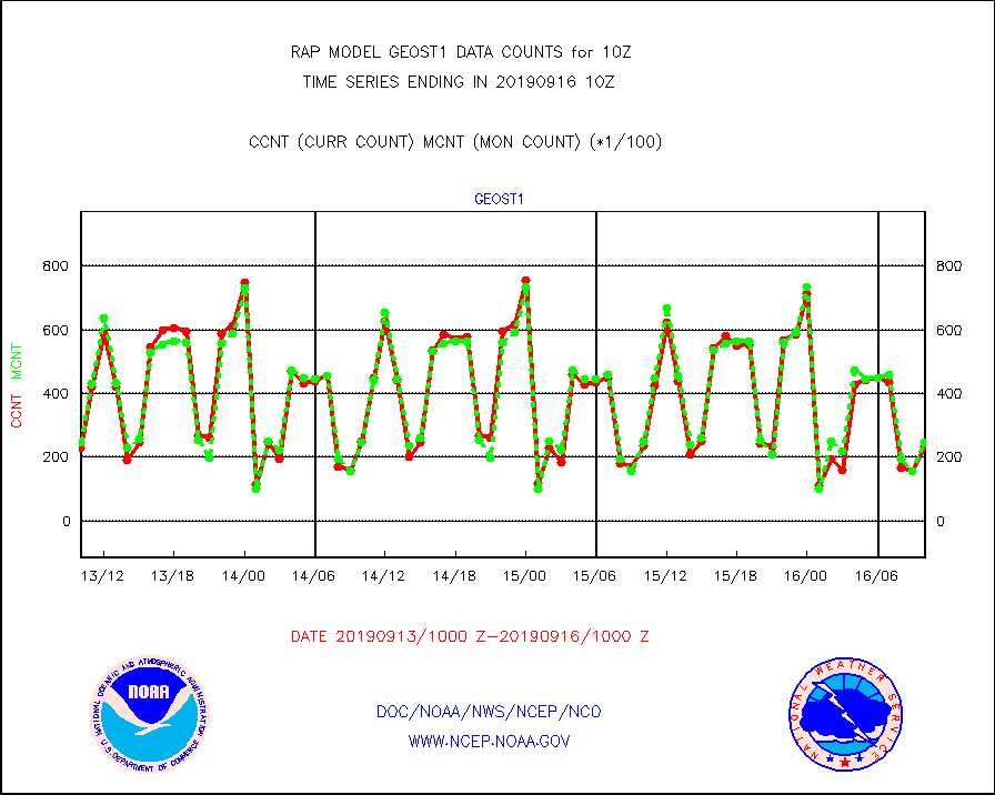
geost1 |
GOES/NESDIS hi-resol. (1x1 f-o-v) sndgs/radiances |
23441 |
24710 |
94.9 % |
1609.00-1611.00 |
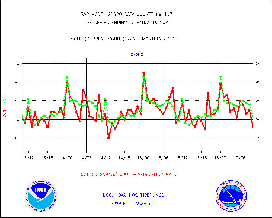
gpsro |
GPS radio occultation data |
16 |
22 |
72.7 % |
1608.00-1611.99 |
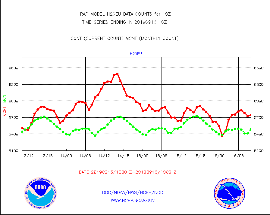
h20eu |
METEOSAT/EUMETSAT wvpr imager derived cld motion |
5744 |
5488 |
104.7 % |
1608.50-1611.49 |
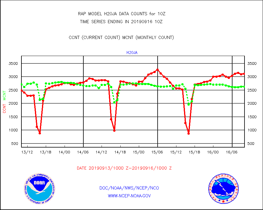
h20ja |
MTSAT/JMA water vapor imager derived cloud motion |
3111 |
2629 |
118.3 % |
1607.50-1612.50 |
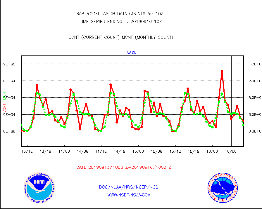
iasidb |
METOP 1-2 IASI 1C radiances-direct broadcast SSEC |
18759 |
10984 |
170.8 % |
1608.00-1611.99 |
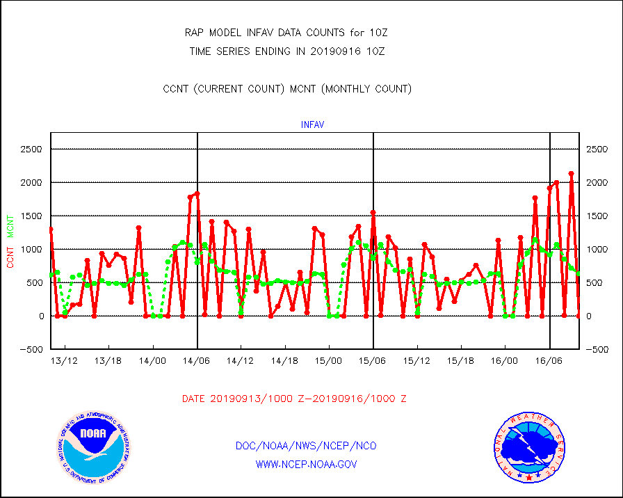
infav |
AVHRR (NOAA/METOP) ir lg-wave derived cld motion |
0 |
626 |
0.0 % |
1607.50-1612.50 |
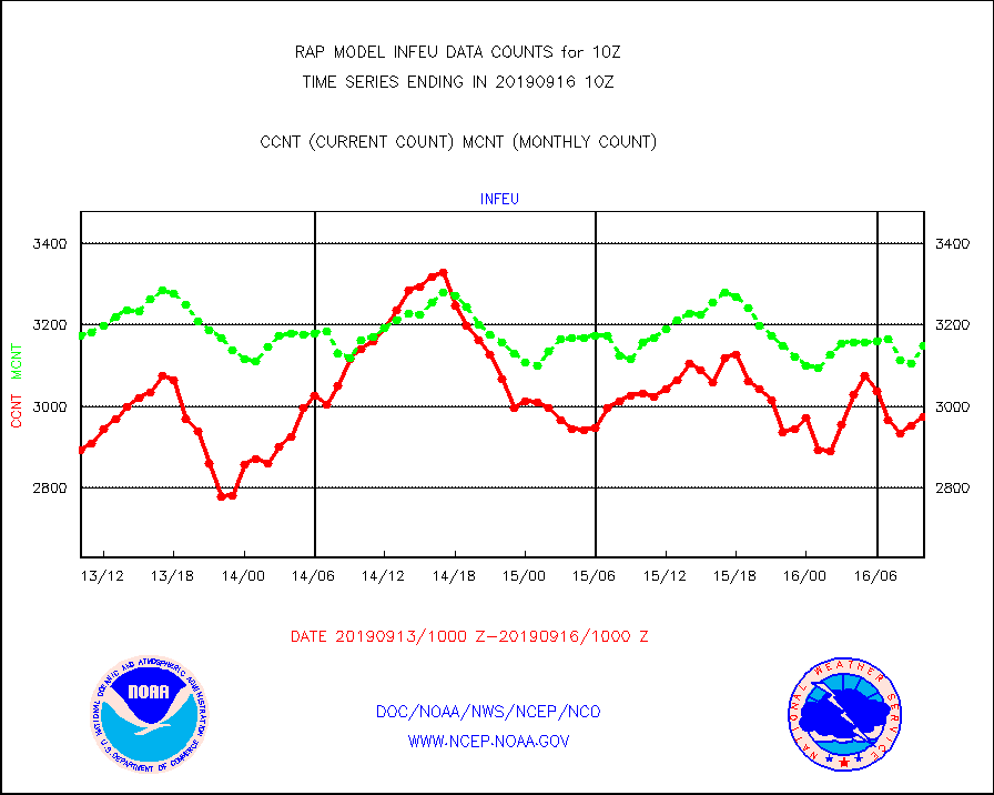
infeu |
METEOSAT/EUMETSAT ir lg-wave derived cloud motion |
2974 |
3148 |
94.5 % |
1608.50-1611.49 |
infja |
MTSAT/JMA infrared long-wave derived cloud motion |
2624 |
2348 |
111.8 % |
1607.50-1612.50 |
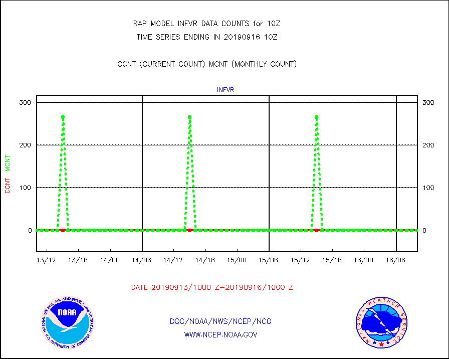
infvr |
VIIRS (NPP) infrared lg-wave derived cloud motion |
0 |
0 |
n/a |
1607.50-1612.50 |
kamdar |
Korean AMDAR aircraft data (decoded from BUFR) |
554 |
606 |
91.4 % |
1606.75-1613.25 |
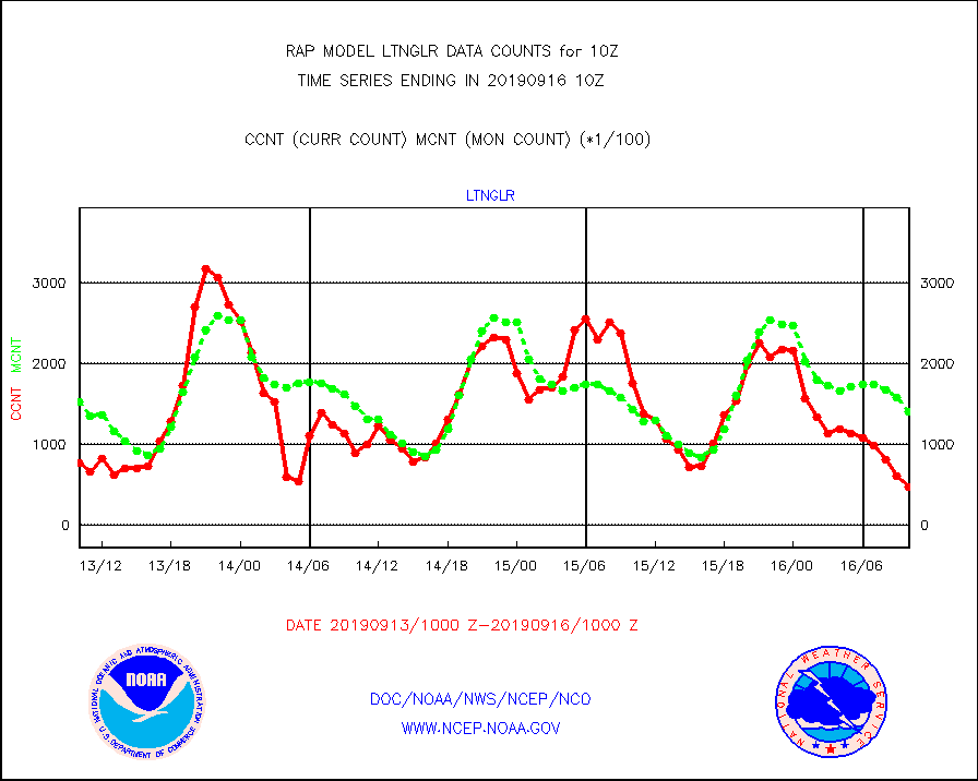
ltnglr |
LLDN Long-rng lightning from Vaisala via NOAAPORT |
47372 |
141468 |
33.5 % |
1609.00-1610.50 |
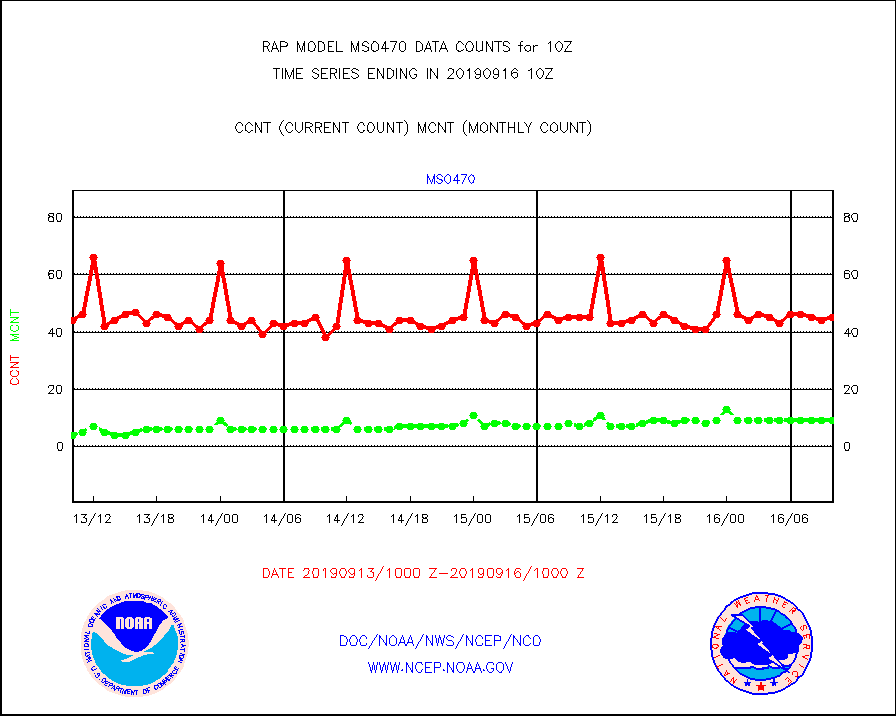
mso470 |
Mesonet/MADIS Colorado E-470 (Interstate 470) |
45 |
9 |
500.0 % |
1609.50-1610.50 |
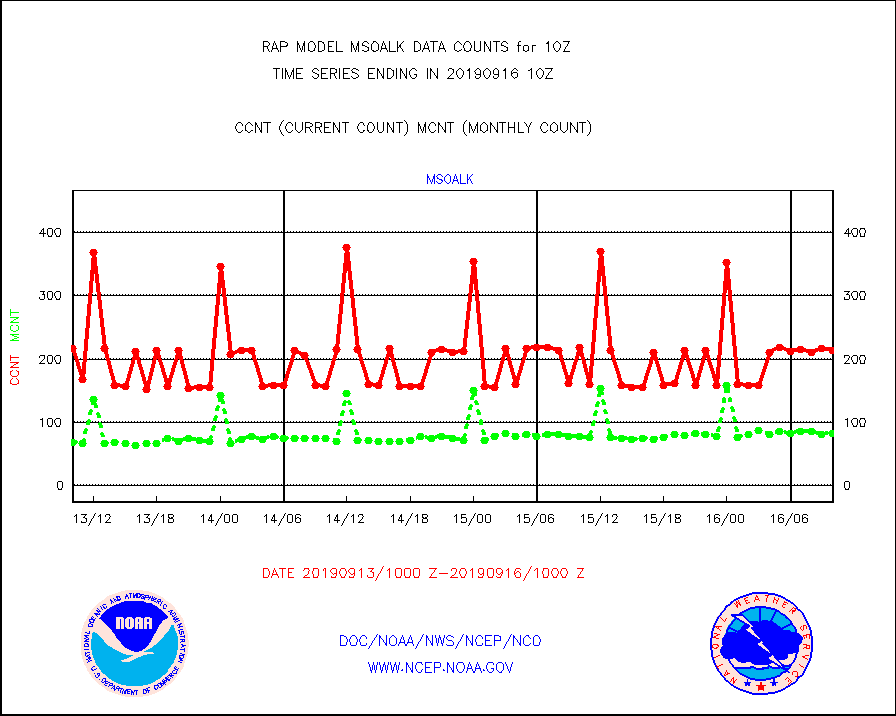
msoalk |
Mesonet/MADIS Alaska Department of Transportation |
213 |
82 |
259.8 % |
1609.50-1610.50 |
msoapg |
Mesonet/MADIS U.S. Army Aberdeen Proving Grounds |
0 |
0 |
n/a |
1609.50-1610.50 |
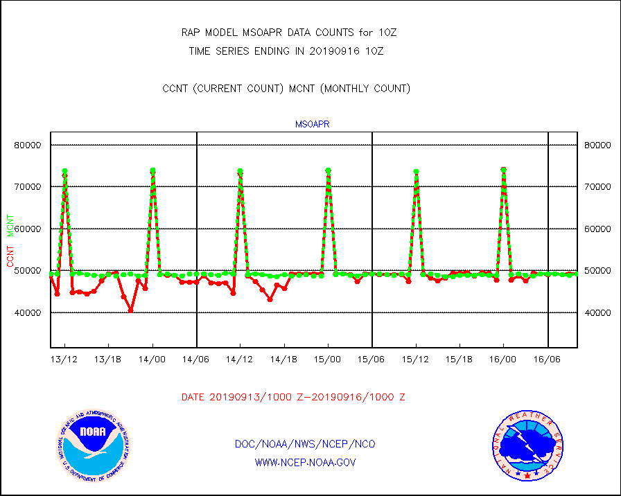
msoapr |
Mesonet/MADIS Citizen Weather Observers Program |
49312 |
49264 |
100.1 % |
1609.50-1610.50 |
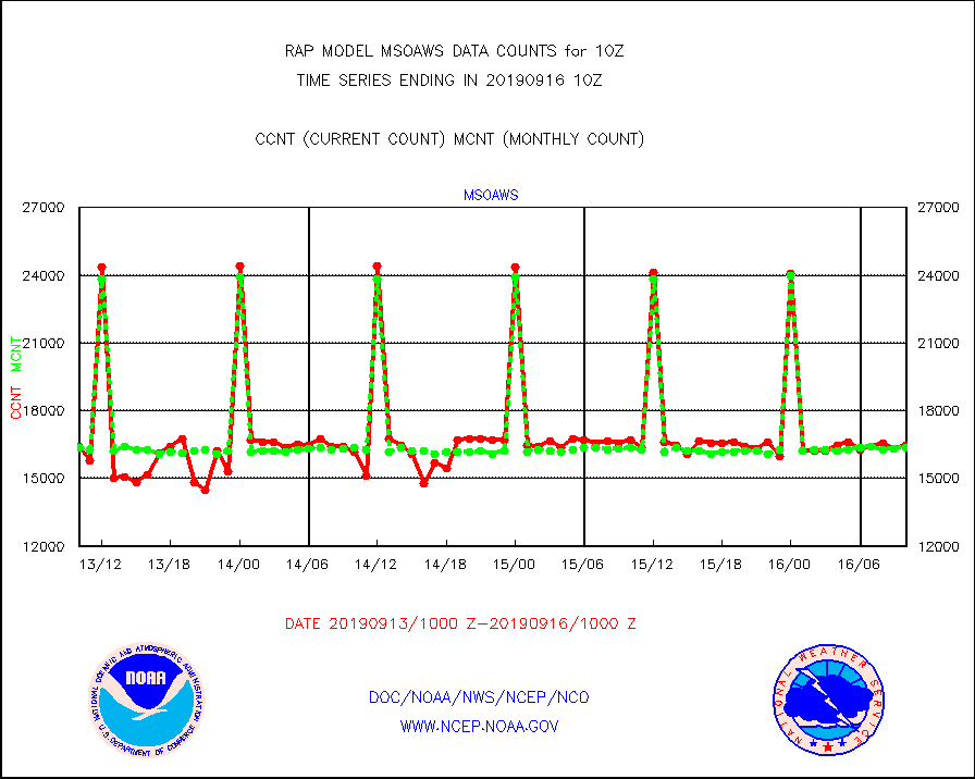
msoaws |
Mesonet/MADIS AWS Convergence Technologies, Inc. |
16477 |
16369 |
100.7 % |
1609.50-1610.50 |
msoawx |
Mesonet/MADIS "Anything Weather" |
0 |
0 |
n/a |
1609.50-1610.50 |
msocol |
Mesonet/MADIS Colorado Dept. of Transportation |
482 |
420 |
114.8 % |
1609.50-1610.50 |
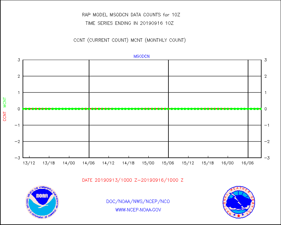
msodcn |
Mesonet/MADIS DC Net |
0 |
0 |
n/a |
1609.50-1610.50 |
msoden |
Mesonet/MADIS Denver Urban Drainage & Flood Cntrl |
0 |
0 |
n/a |
1609.50-1610.50 |
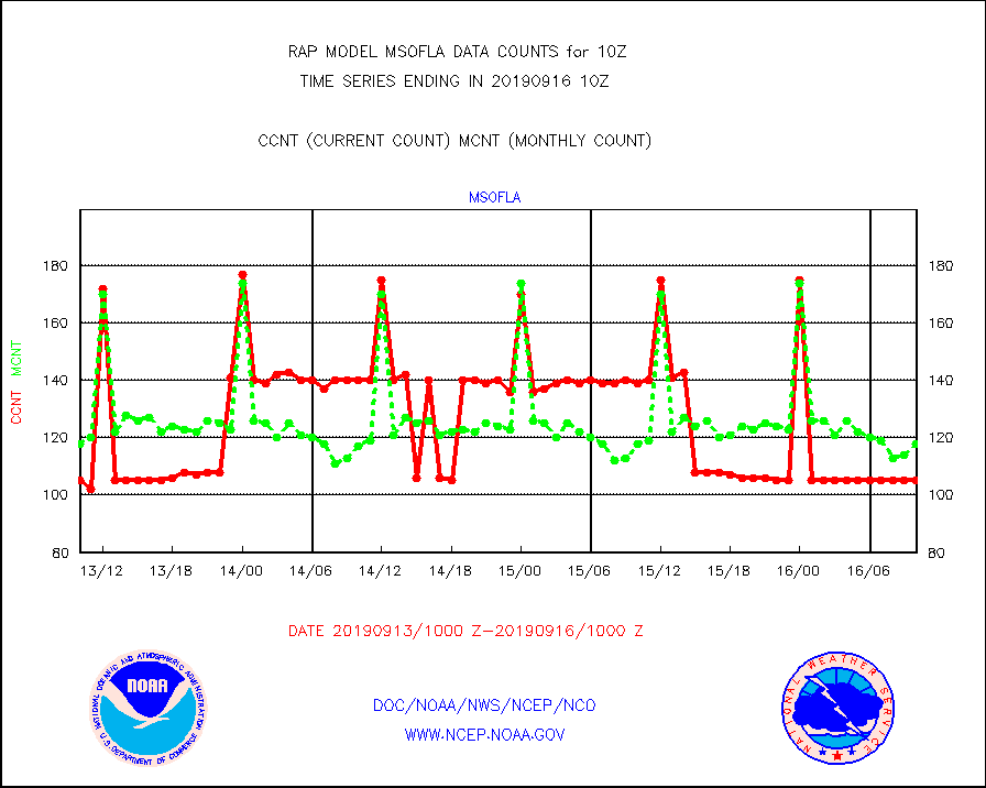
msofla |
Mesonet/MADIS Florida (FAWN & USF) |
105 |
118 |
89.0 % |
1609.50-1610.50 |
msoflt |
Mesonet/MADIS Florida Dept. of Transportation |
0 |
0 |
n/a |
1609.50-1610.50 |
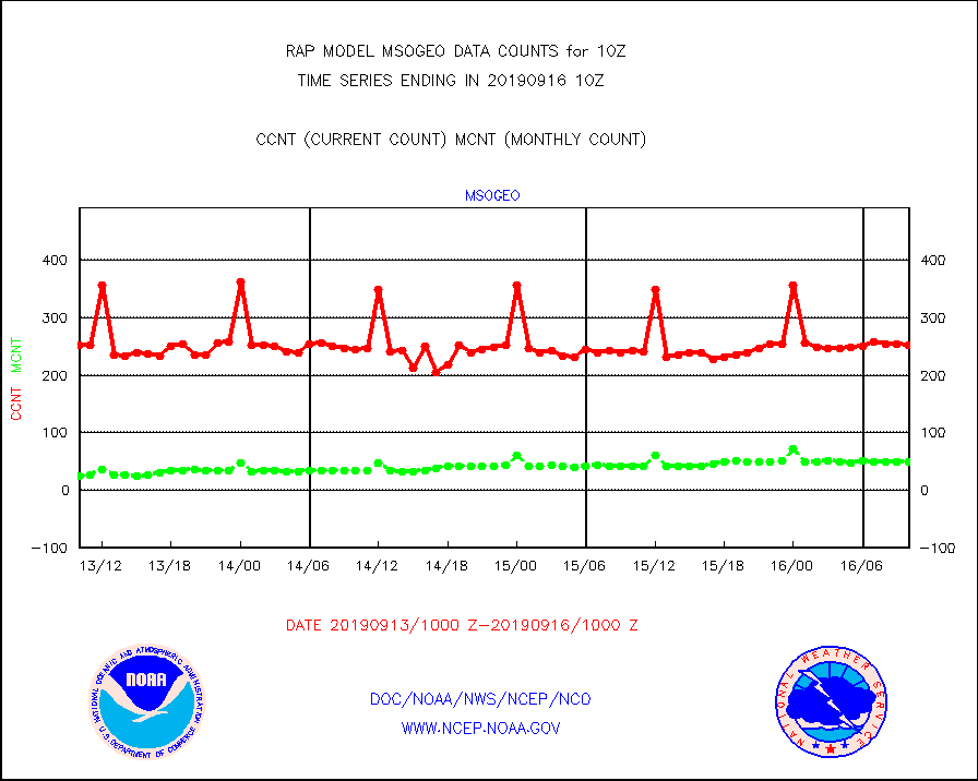
msogeo |
Mesonet/MADIS Georgia Dept. of Transportation |
253 |
50 |
506.0 % |
1609.50-1610.50 |
msohad |
Mesonet/MADIS NWS Hydromet Auto Data System(HADS) |
4360 |
4301 |
101.4 % |
1609.50-1610.50 |
msoien |
Mesonet/MADIS Iowa Environmental |
19 |
4 |
475.0 % |
1609.50-1610.50 |
msoind |
Mesonet/MADIS Indiana Dept. of Transportation |
124 |
29 |
427.6 % |
1609.50-1610.50 |
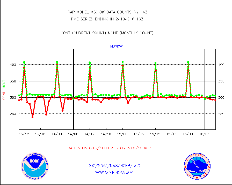
msoiow |
Mesonet/MADIS Iowa Department of Transportation |
291 |
304 |
95.7 % |
1609.50-1610.50 |
msokan |
Mesonet/MADIS Kansas Department of Transportation |
321 |
328 |
97.9 % |
1609.50-1610.50 |
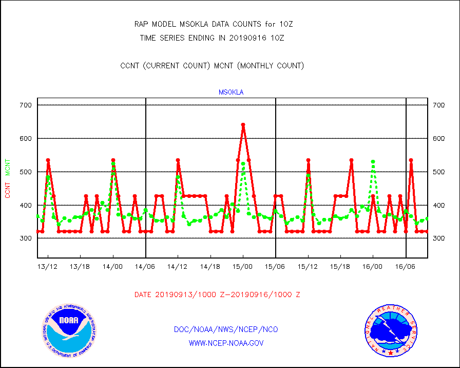
msokla |
Mesonet/MADIS Oklahoma Mesonet |
321 |
360 |
89.2 % |
1609.50-1610.50 |
msolju |
Mesonet/MADIS Louisiana State/Jackson State Univ. |
0 |
0 |
n/a |
1609.50-1610.50 |
msomca |
Mesonet/MADIS Missouri Commercial Agricult Wx Net |
263 |
253 |
104.0 % |
1609.50-1610.50 |
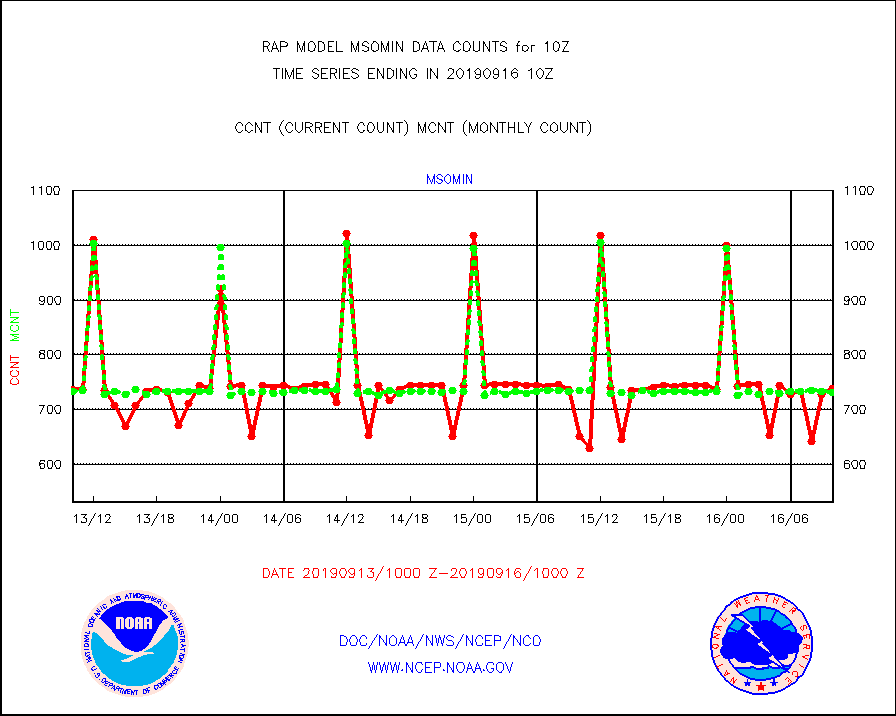
msomin |
Mesonet/MADIS Minnesota Dept. of Transportation |
739 |
731 |
101.1 % |
1609.50-1610.50 |
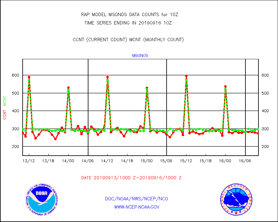
msonos |
Mesonet/MADIS NOS-Phys Oceanographic Realtime Sys |
273 |
298 |
91.6 % |
1609.50-1610.50 |
msoraw |
Mesonet/MADIS NFIC Remote Automated Wx Stns(RAWS) |
1586 |
1557 |
101.9 % |
1609.50-1610.50 |
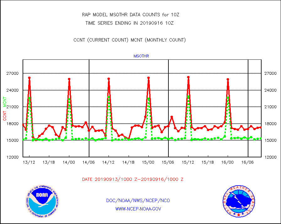
msothr |
Mesonet/MADIS many providers, not separated out |
17284 |
15352 |
112.6 % |
1609.50-1610.50 |
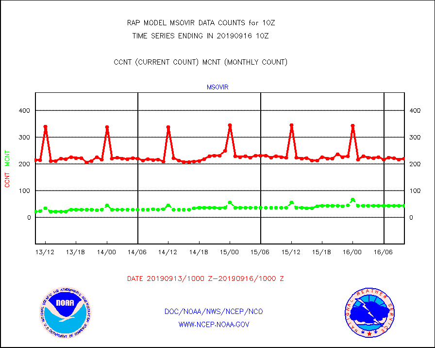
msovir |
Mesonet/MADIS Virginia Dept. of Transportation |
220 |
44 |
500.0 % |
1609.50-1610.50 |
msowfy |
Mesonet/MADIS "Weather for You" |
51 |
56 |
91.1 % |
1609.50-1610.50 |
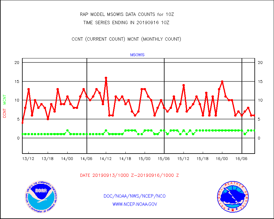
msowis |
Mesonet/MADIS Wisconsin Dept. of Transportation |
6 |
2 |
300.0 % |
1609.50-1610.50 |
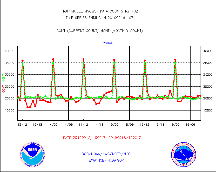
msowst |
Mesonet/MADIS MesoWest (many subproviders) |
21027 |
20061 |
104.8 % |
1609.50-1610.50 |
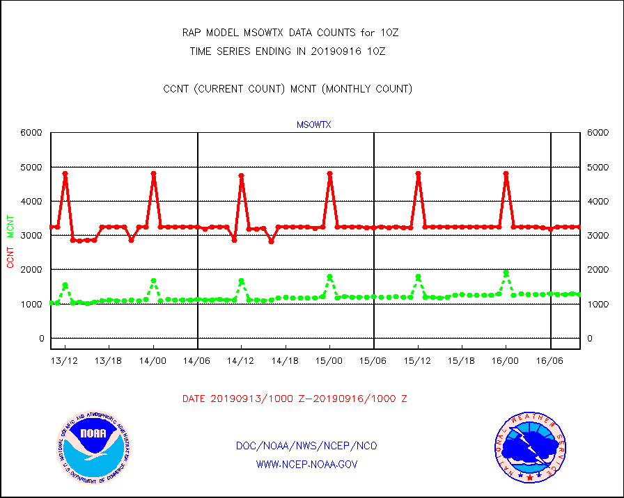
msowtx |
Mesonet/MADIS West Texas |
3244 |
1282 |
253.0 % |
1609.50-1610.50 |
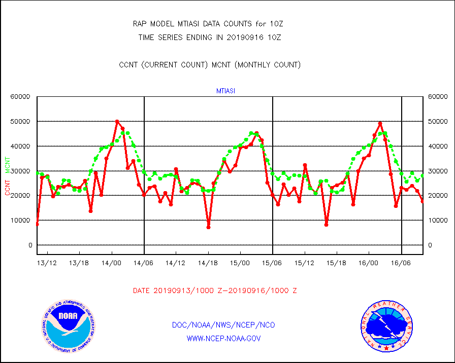
mtiasi |
METOP 1-2 IASI 1C radiance data (varbl. channels) |
17606 |
28013 |
62.8 % |
1608.00-1611.99 |
nxrdw2 |
NEXRAD Vel Azm Dsp(VAD) winds via Level 2 decoder |
600 |
798 |
75.2 % |
1609.00-1611.00 |
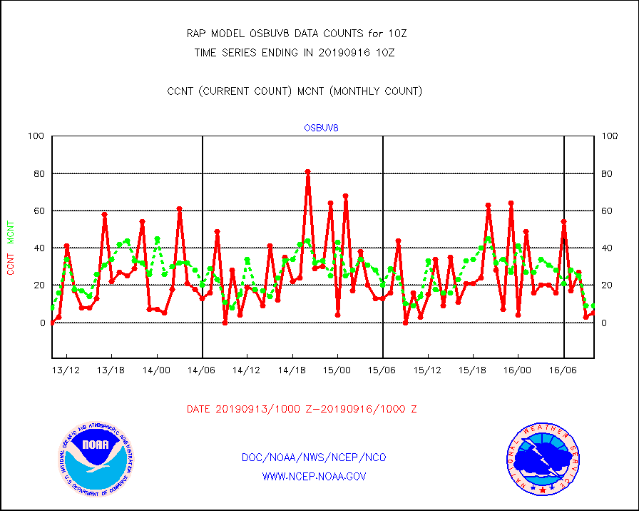
osbuv8 |
NOAA 16-19 Solar Backscatter UV-2 rad frm V8 BUFR |
5 |
9 |
55.6 % |
1608.00-1610.99 |
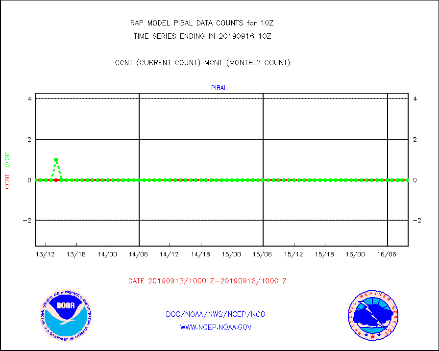
pibal |
PIBAL (from PILOT, PILOT SHIP, PILOT MOBIL) |
0 |
0 |
n/a |
1609.00-1611.00 |
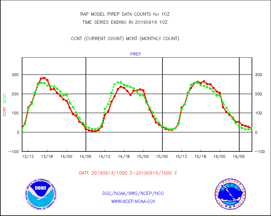
pirep |
Manual PIREP aircraft data (dcded from AIREP fmt) |
18 |
20 |
90.0 % |
1606.75-1613.25 |
prflrp |
Profilr winds from PIBAL (PILOT,PILOT SHIP/MOBIL) |
0 |
0 |
n/a |
1608.50-1611.50 |
radw25 |
NEXRAD radial wind superobs (Level 2.5 - ORPG) |
0 |
0 |
n/a |
1609.00-1611.00 |
radw30 |
NEXRAD radial wind superobs (Level 3 - NIDS) |
0 |
0 |
n/a |
1609.00-1611.00 |
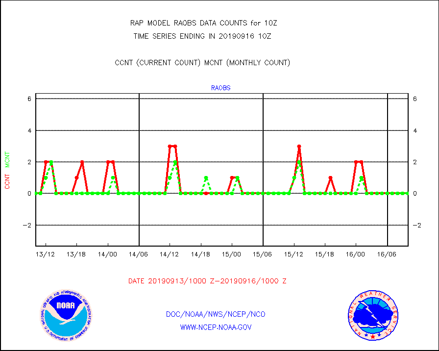
raobm |
Rawinsonde - mobile land (from TEMP/PILOT MOBIL) |
0 |
0 |
n/a |
1609.00-1611.00 |
raobs |
Rawinsonde - ship (from TEMP SHIP, PILOT SHIP) |
0 |
0 |
n/a |
1609.00-1611.00 |
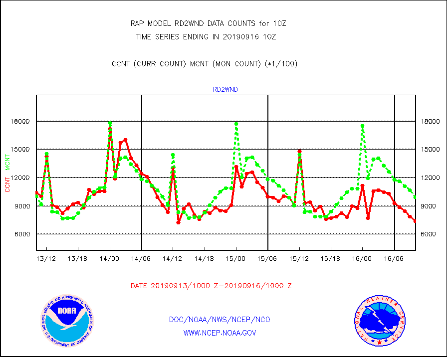
rd2wnd |
NEXRAD radial wind (Level 2 - GTS) |
742293 |
992156 |
74.8 % |
1609.50-1610.49 |
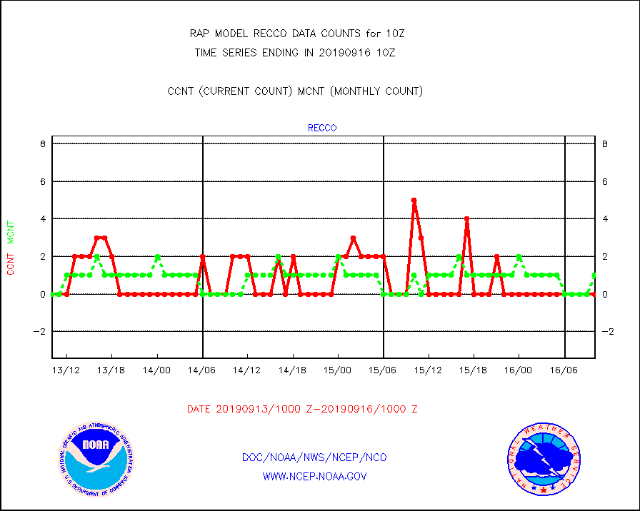
recco |
Flight level reconnaissance aircraft data |
0 |
1 |
0.0 % |
1609.00-1611.00 |
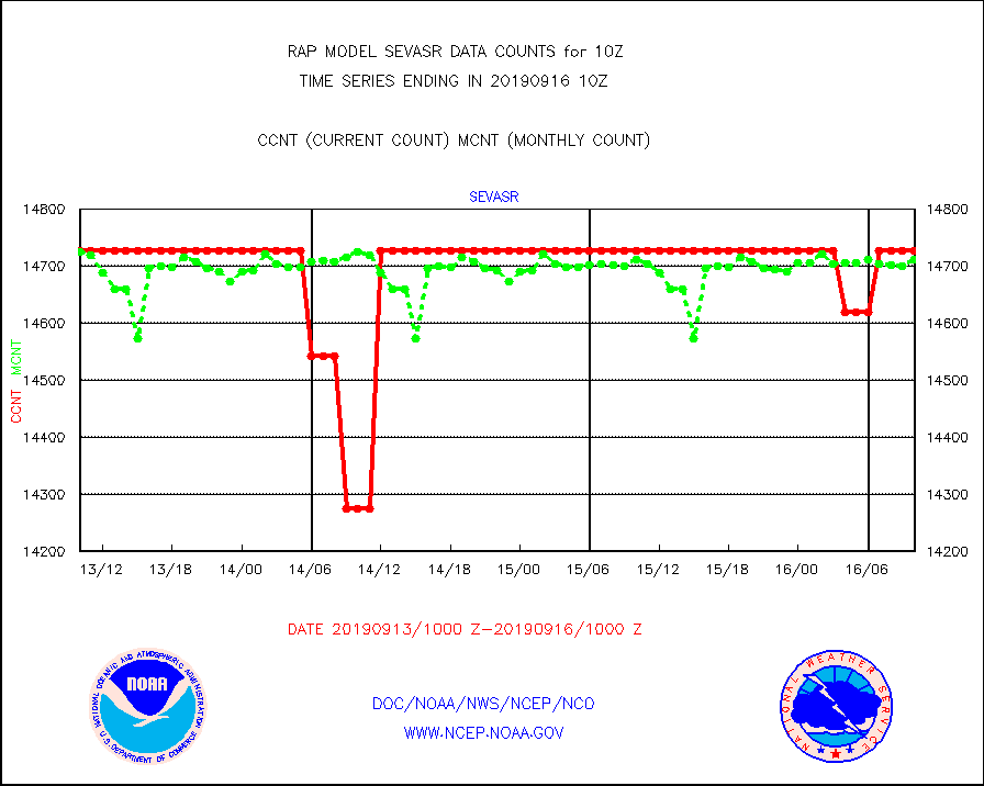
sevasr |
METEOSAT-10 2nd Gen SEVIRI All Sky Radiance(proc) |
14727 |
14711 |
100.1 % |
1608.00-1611.99 |
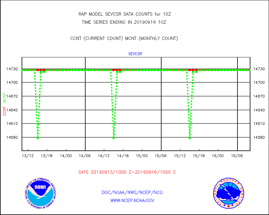
sevcsr |
METEOSAT-10 2nd Gen SEVIRI Clr Sky Radiance(proc) |
14727 |
14727 |
100.0 % |
1608.00-1611.99 |
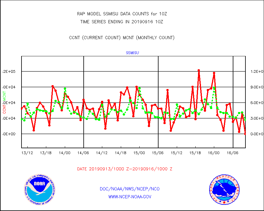
ssmisu |
DMSP SSM/IS 1C radiance data (Unified Pre-Proc.) |
0 |
27044 |
0.0 % |
1608.00-1611.99 |
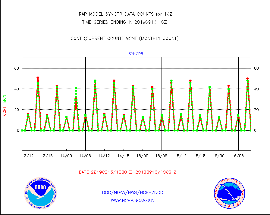
synopr |
Synoptic - restricted (WMO Res 40) manual & auto. |
0 |
0 |
n/a |
1609.50-1610.50 |
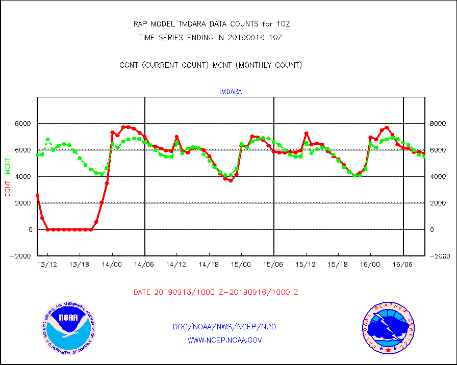
tmdara |
TAMDAR aircft data-all types(from Panasonic,BUFR) |
5733 |
5483 |
104.6 % |
1606.75-1613.25 |
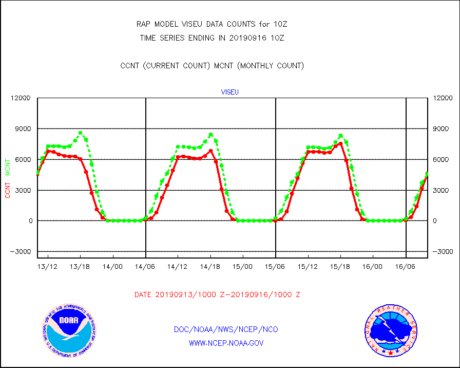
viseu |
METEOSAT/EUMETSAT visible derived cloud motion |
4616 |
4576 |
100.9 % |
1608.50-1611.49 |
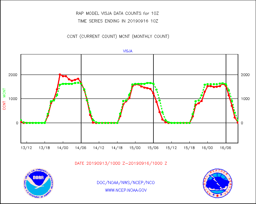
visja |
MTSAT/JMA visible derived cloud motion |
10 |
104 |
9.6 % |
1607.50-1612.50 |
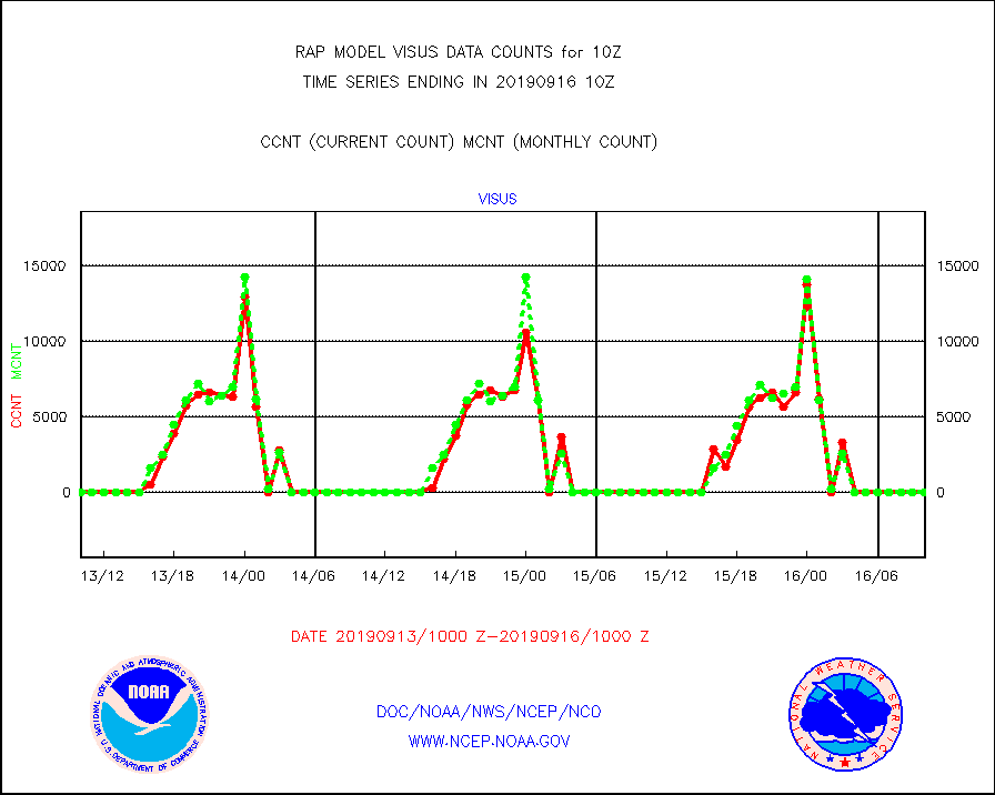
visus |
GOES/NESDIS visible derived cloud motion |
0 |
0 |
n/a |
1609.00-1609.99 |


