| Critical Data with Normal Counts |
|---|
| Type | Description | Hourly Count | Monthly Average | Percent (%) of Monthly Mean | UTC Time Window |
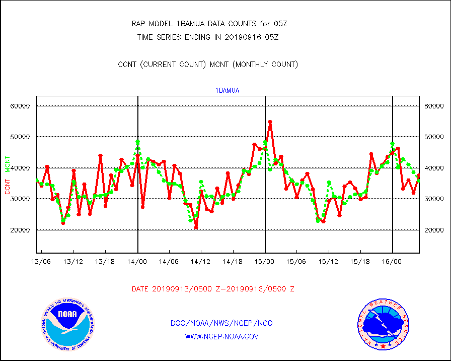
1bamua |
NOAA 15-19 & METOP 1-2 AMSU-A NCEP-proc. br.temps |
37680 |
35921 |
104.9 % |
1602.00-1607.99 |
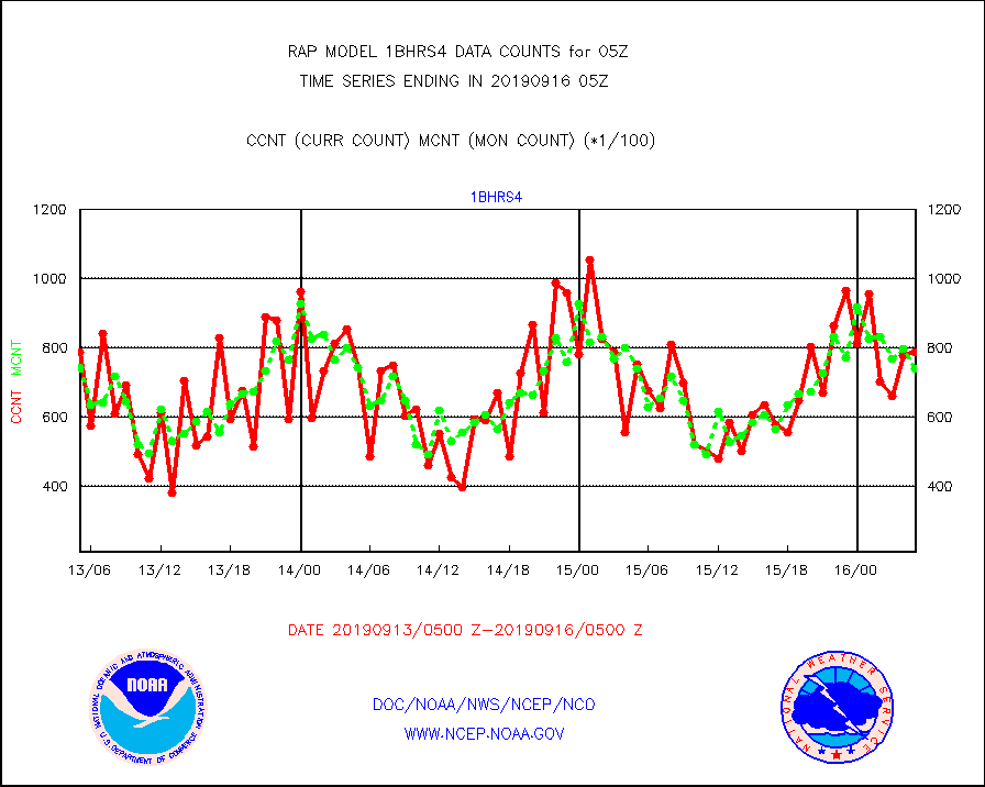
1bhrs4 |
NOAA 18-19 & METOP 1-2 HIRS-4 NCEP-proc. br.temps |
78878 |
74101 |
106.4 % |
1602.00-1607.99 |
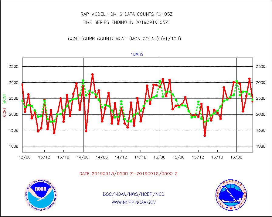
1bmhs |
NOAA 18-19 & METOP 1-2 MHS NCEP-proces. br. temps |
240679 |
245851 |
97.9 % |
1602.00-1607.99 |
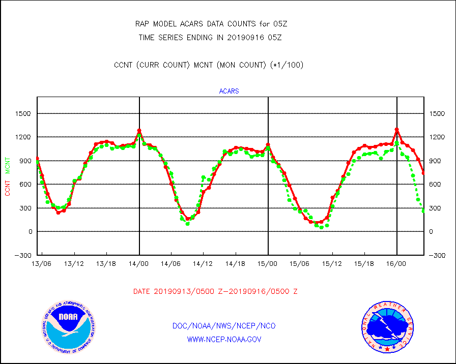
acars |
MDCRS ACARS acft data from ARINC(dcded from BUFR) |
74164 |
26136 |
283.8 % |
1601.75-1608.25 |
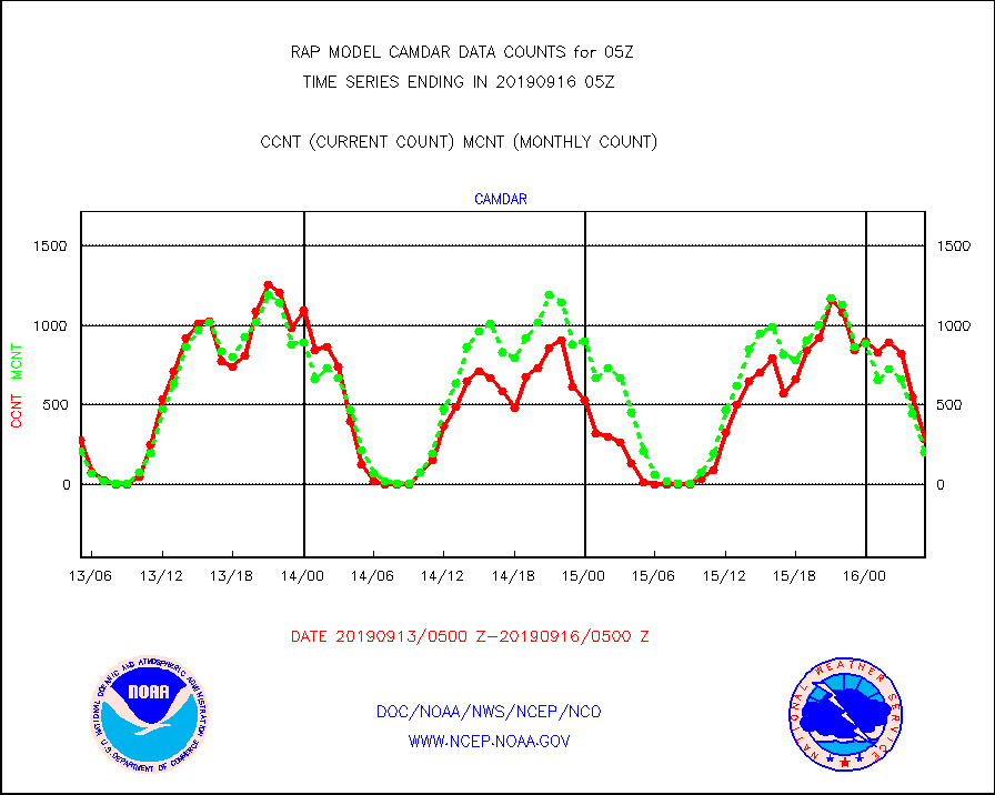
camdar |
Canadian AMDAR aircraft data (decoded from BUFR) |
288 |
202 |
142.6 % |
1601.75-1608.25 |
dbuoy |
Buoys decoded from FM-18 fmt (moored or drifting) |
12 |
31 |
38.7 % |
1604.50-1605.50 |
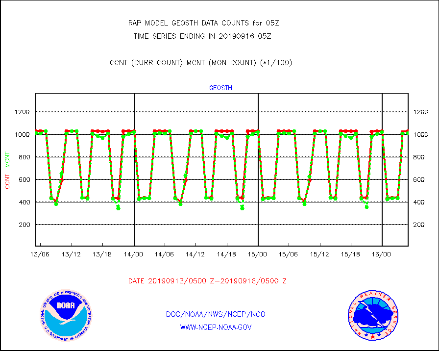
geosth |
GOES/NESDIS hi-resol. (1x1 f-o-v) cloud data |
102806 |
101275 |
101.5 % |
1603.75-1604.99 |
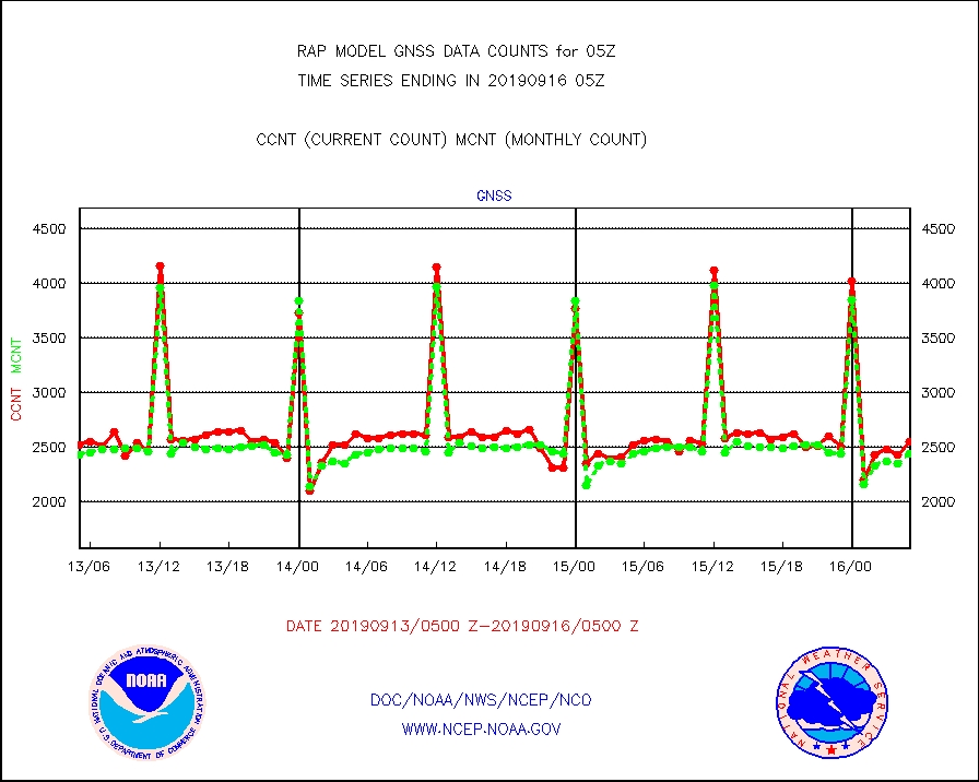
gnss |
Grnd-based Gbl Navigation Sat System (GNSS) data |
2545 |
2439 |
104.3 % |
1603.95-1604.05 |
h20mo |
MODIS (AQUA/TERRA) wvpr imager derived cld motion |
0 |
0 |
n/a |
1602.50-1607.50 |
h2ius |
GOES/NESDIS water vapor imager derived cld motion |
3924 |
4063 |
96.6 % |
1604.00-1604.99 |
infmo |
MODIS (AQUA/TERRA) ir l-wave derived cloud motion |
0 |
0 |
n/a |
1602.50-1607.50 |
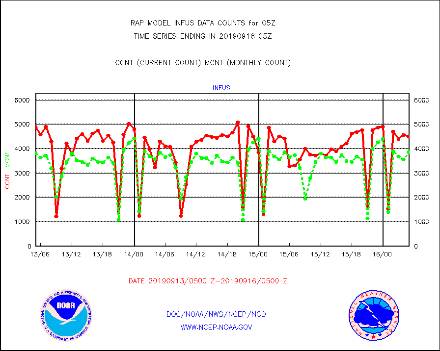
infus |
GOES/NESDIS infrared lg-wave derived cloud motion |
4507 |
3861 |
116.7 % |
1604.00-1604.99 |
lcman |
Land-based CMAN stations decoded from CMAN format |
387 |
418 |
92.6 % |
1604.50-1605.50 |
lgycld |
GOES/NASA(Langley) hi-res. (1x1 f-o-v) cloud data |
3597191 |
3571593 |
100.7 % |
1604.50-1605.50 |
mbuoy |
Buoys decoded from FM-13 format (moored) |
556 |
575 |
96.7 % |
1604.50-1605.50 |
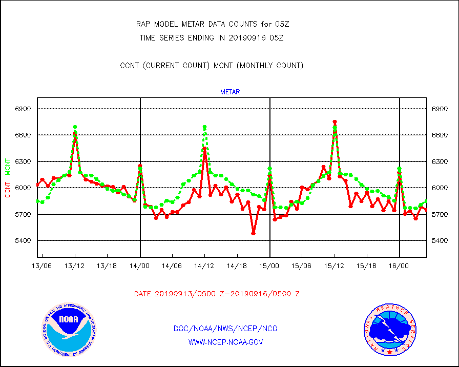
metar |
Aviation - METAR |
5752 |
5847 |
98.4 % |
1604.50-1605.50 |
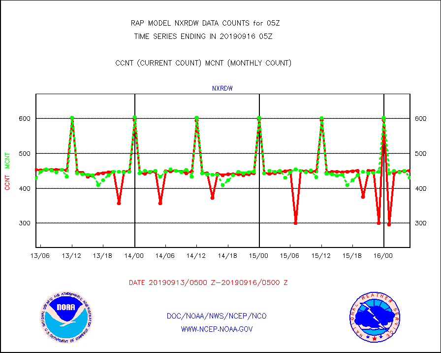
nxrdw |
NEXRAD Vel Azm Dsp(VAD) winds via radar coded msg |
450 |
430 |
104.7 % |
1604.00-1606.00 |
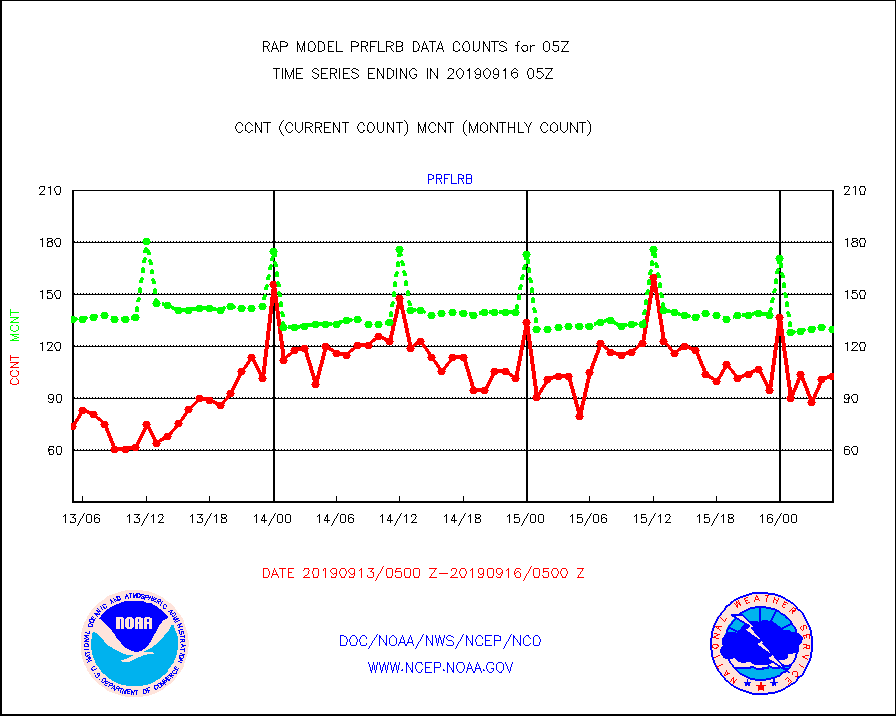
prflrb |
Multi-Agency Profiler (MAP) and SODAR winds |
103 |
130 |
79.2 % |
1603.50-1606.50 |
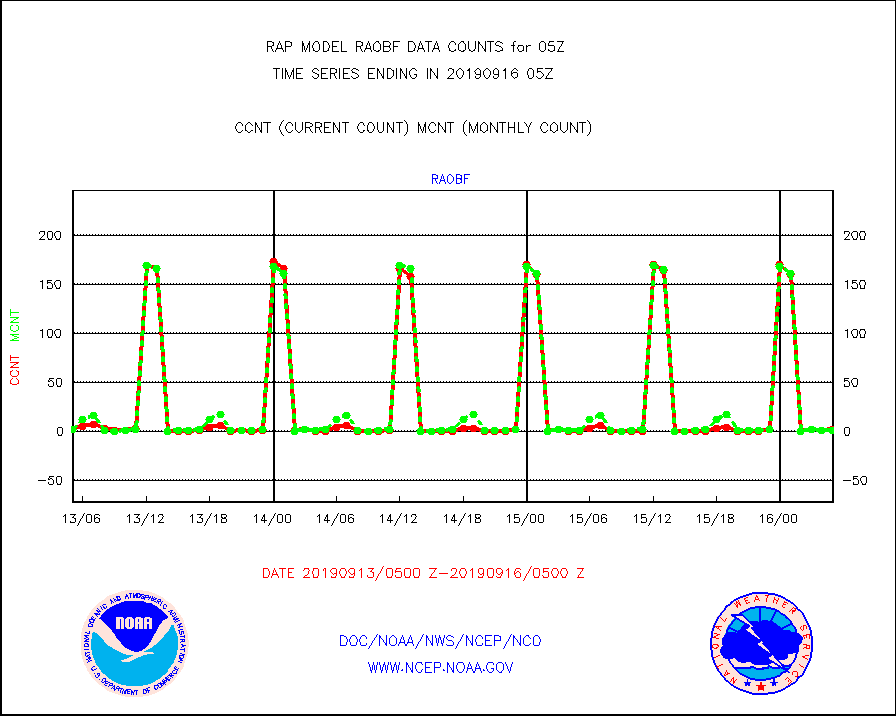
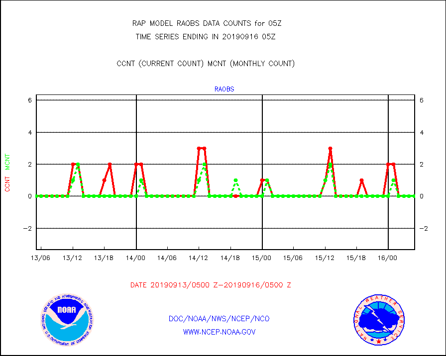
raobf |
Rawinsonde - fixed land (from TEMP or PILOT) |
2 |
1 |
200.0 % |
1604.00-1606.00 |
rass |
RASS temperatures (NOAA and Multi-Agency) |
21 |
33 |
63.6 % |
1604.50-1605.50 |
ships |
Ship - manual and automatic, restricted |
92 |
93 |
98.9 % |
1604.50-1605.50 |
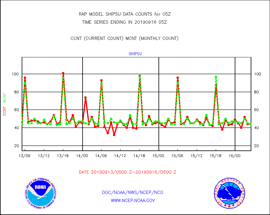
shipsu |
Ship - manual and automatic, unrestricted |
44 |
44 |
100.0 % |
1604.50-1605.50 |
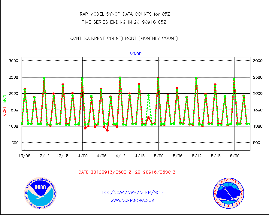
synop |
Synoptic - fixed manual and automatic |
1079 |
1080 |
99.9 % |
1604.50-1605.50 |
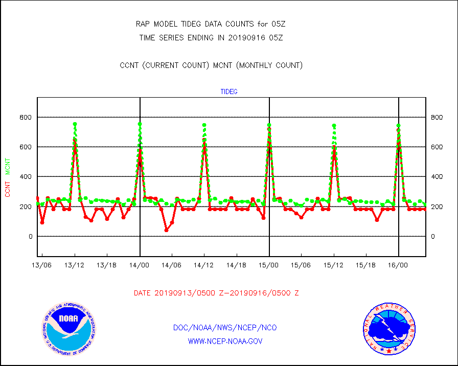
tideg |
Tide gauge reports decoded from CREX format |
183 |
214 |
85.5 % |
1604.50-1605.50 |
| Data Types of Opportunity with Normal Counts |
|---|
| Type | Description | Hourly Count | Monthly Average | Percent (%) of Monthly Mean | UTC Time Window |
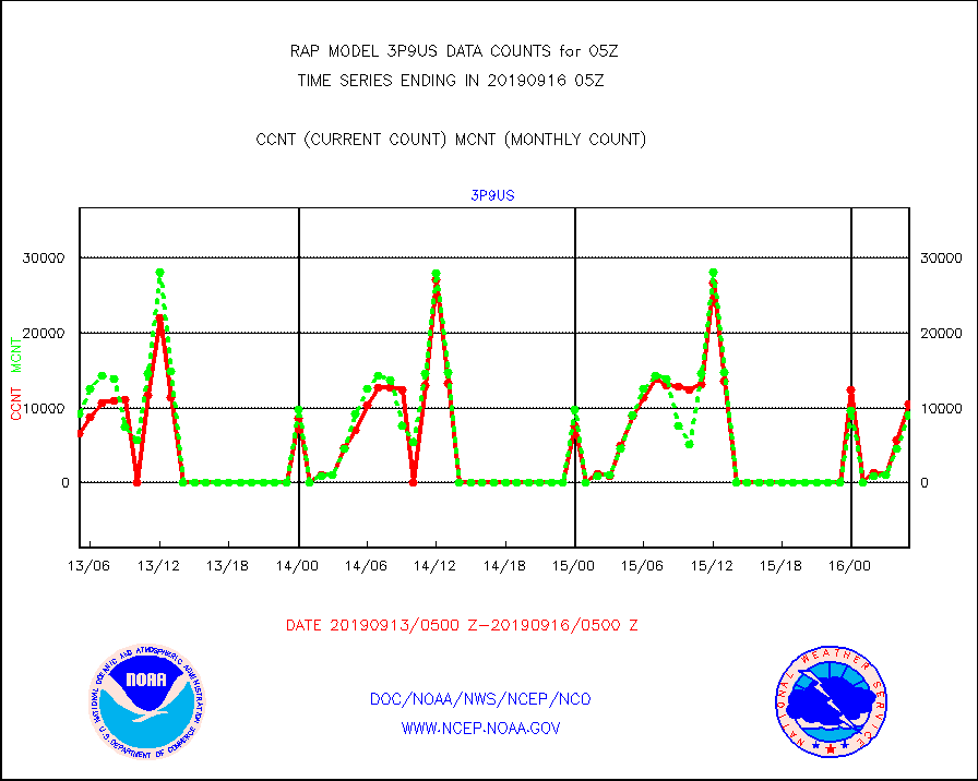
3p9us |
GOES/NESDIS infrared shrt-wave derived cld motion |
10558 |
9110 |
115.9 % |
1604.00-1604.99 |
acarsa |
MDCRS ACARS acft data (ARINC via AFWA)(AIREP fmt) |
0 |
0 |
n/a |
1601.75-1608.25 |
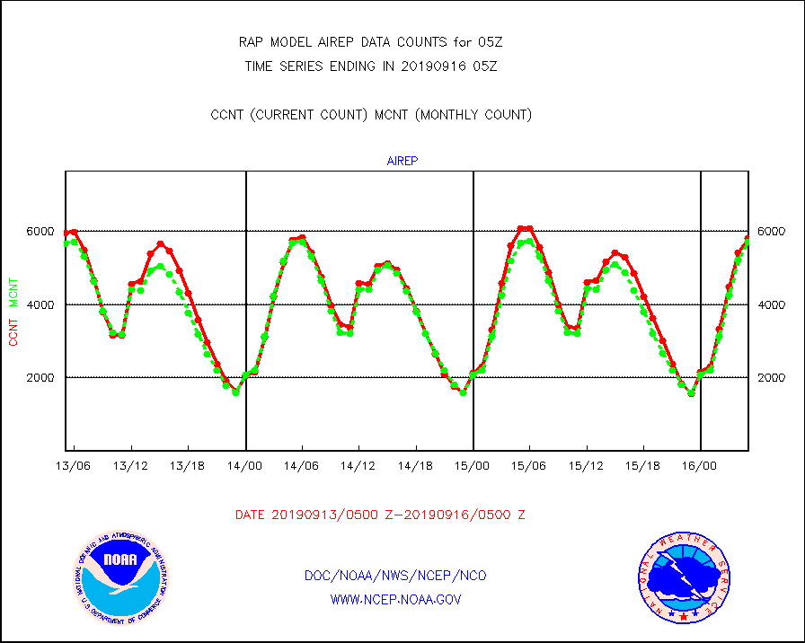
airep |
Manual AIREP aircraft data (dcded from AIREP fmt) |
5812 |
5706 |
101.9 % |
1601.75-1608.25 |
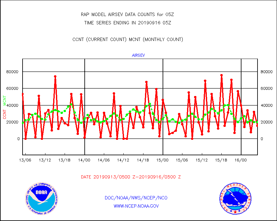
airsev |
AQUA AIRS/AMSU-A/HSB brightness temps- every FOV |
15512 |
19792 |
78.4 % |
1602.00-1607.99 |
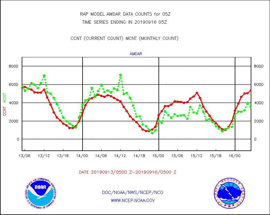
amdar |
AMDAR aircraft data (decoded from AMDAR format) |
5346 |
3471 |
154.0 % |
1601.75-1608.25 |
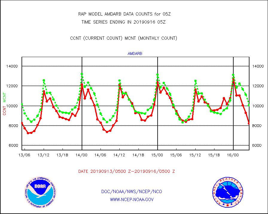
amdarb |
AMDAR aircraft data (decoded from BUFR) |
8211 |
10057 |
81.6 % |
1601.75-1608.25 |
amsr2 |
GCOM-W AMSR2 1B brightness temperatures |
978960 |
569100 |
172.0 % |
1602.00-1602.99 |
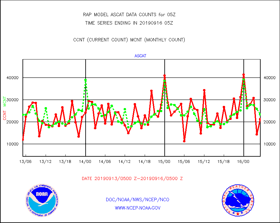
ascat |
METOP 1-2 ASCAT products |
21226 |
23341 |
90.9 % |
1603.00-1607.00 |
atms |
NPP Adv. Tech. Microwave Sounder (ATMS) br. temps |
68412 |
83260 |
82.2 % |
1603.00-1606.99 |
atmsdb |
NPP Adv Tech MW Sndr(ATMS) b. temps-dir bcst SSEC |
4962 |
10549 |
47.0 % |
1603.00-1606.99 |
cris |
NPP Cross-track Infrared Sounder (CrIS) radiances |
6004 |
18649 |
32.2 % |
1603.00-1606.99 |
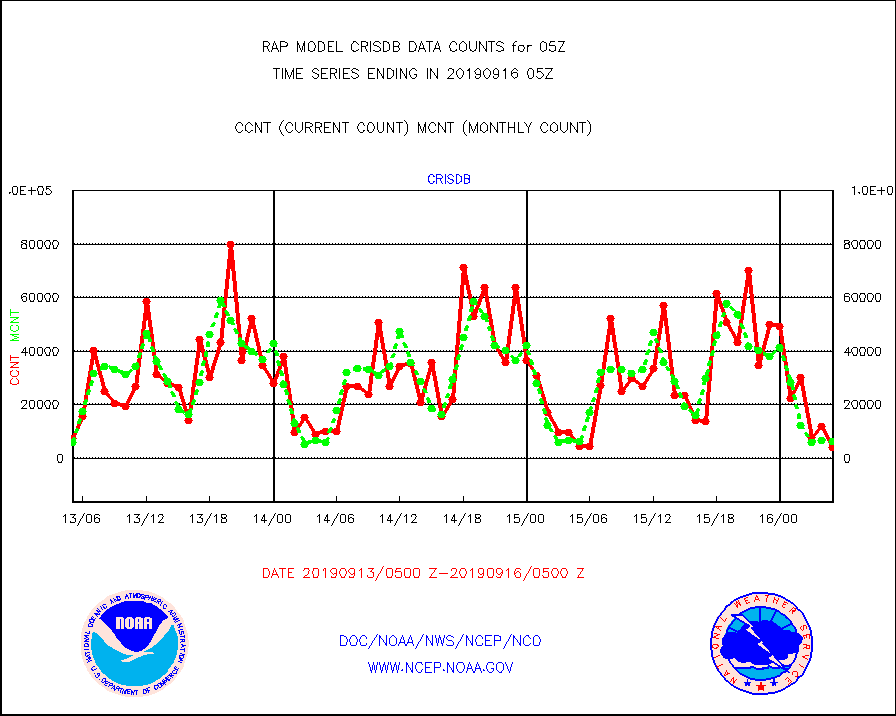
crisdb |
NPP Crss-trk IR Sndr(CrIS) radiance-dir bcst SSEC |
3869 |
6219 |
62.2 % |
1603.00-1606.99 |
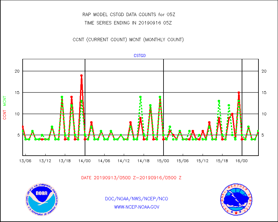
cstgd |
Coast Guard |
6 |
6 |
100.0 % |
1604.50-1605.50 |
dropw |
Dropwinsonde (from TEMP DROP) |
0 |
2 |
0.0 % |
1604.00-1606.00 |
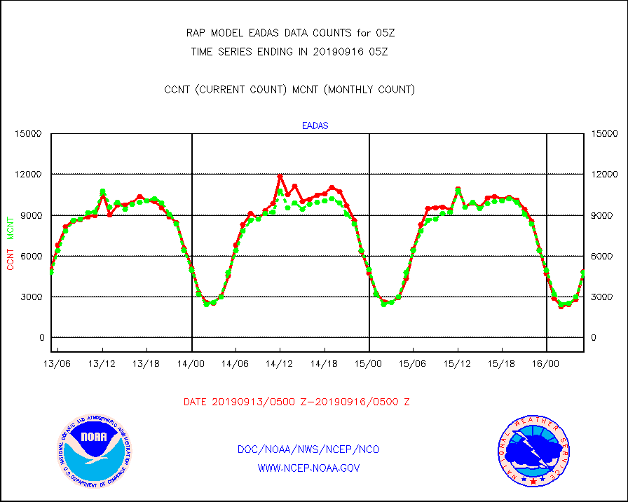
eadas |
E-AMDAR (European AMDAR acft decoded from BUFR) |
4843 |
4778 |
101.4 % |
1601.75-1608.25 |
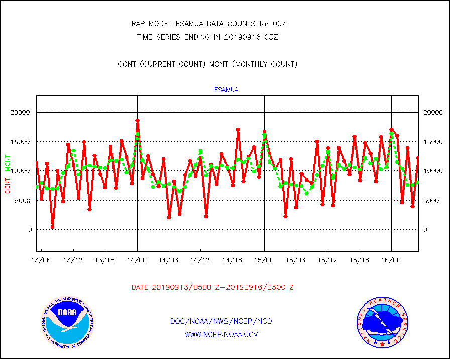
esamua |
NOAA 15-19 & METOP 1-2 AMSU-A proc btmps frm RARS |
12245 |
8187 |
149.6 % |
1604.00-1606.00 |
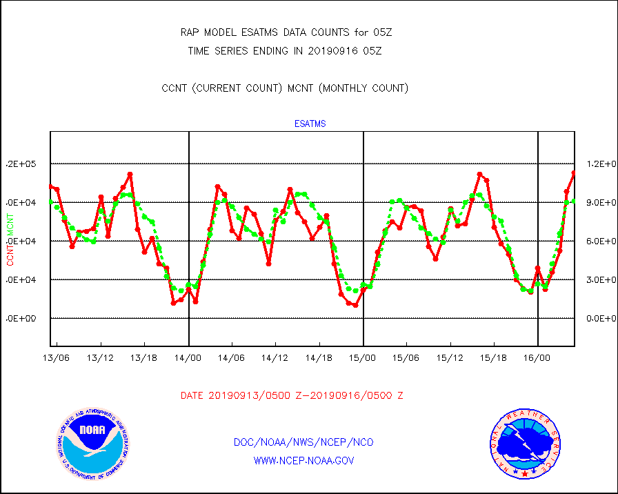
esatms |
NPP Adv. Tech. MW Sndr (ATMS) br. temps from RARS |
113155 |
91317 |
123.9 % |
1603.00-1606.99 |
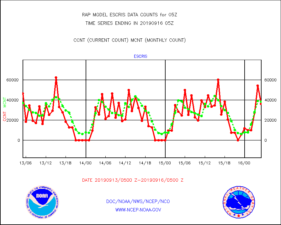
escris |
NPP Crss-track IR Sndr (CrIS) radiances from RARS |
36339 |
38468 |
94.5 % |
1603.00-1606.99 |
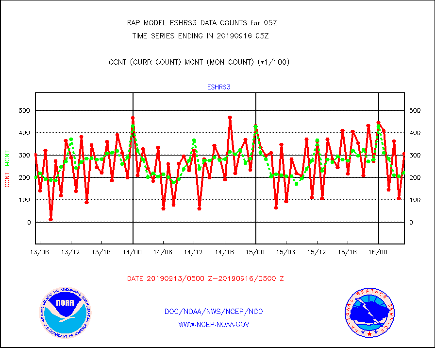
eshrs3 |
NOAA 15-19 & METOP 1-2 HIRS-3/4 pr btmps frm RARS |
30657 |
22242 |
137.8 % |
1604.00-1606.00 |
esiasi |
METOP 1-2 IASI 1C radiance data vbl chn from RARS |
69039 |
52723 |
130.9 % |
1603.00-1606.99 |
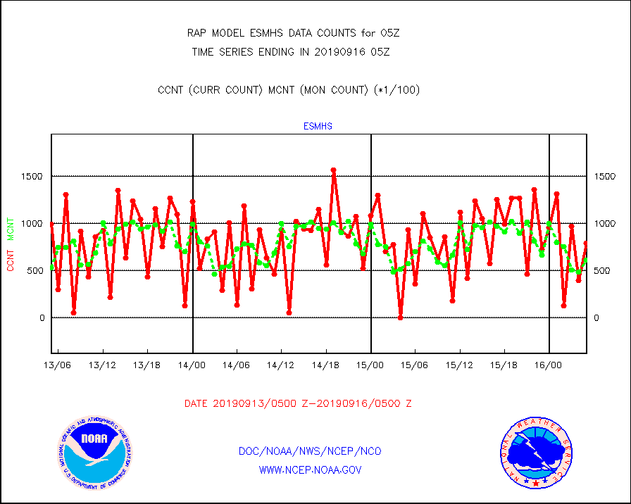
esmhs |
NOAA 18-19 & METOP 1-2 MHS proc. btemps from RARS |
78908 |
60867 |
129.6 % |
1604.00-1606.00 |
geost1 |
GOES/NESDIS hi-resol. (1x1 f-o-v) sndgs/radiances |
44151 |
44616 |
99.0 % |
1604.00-1606.00 |
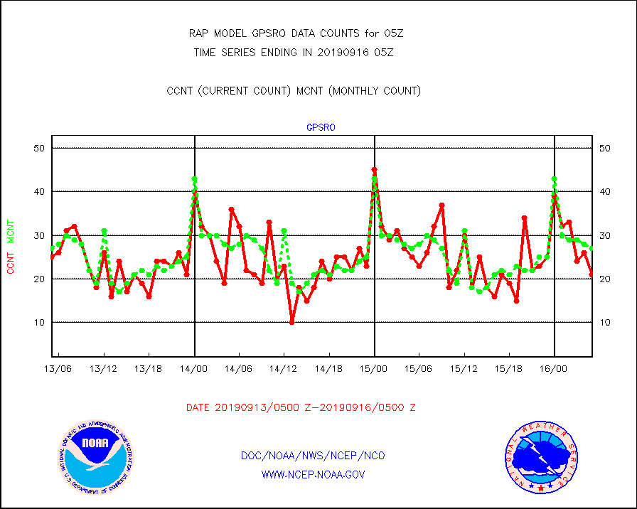
gpsro |
GPS radio occultation data |
21 |
27 |
77.8 % |
1603.00-1606.99 |
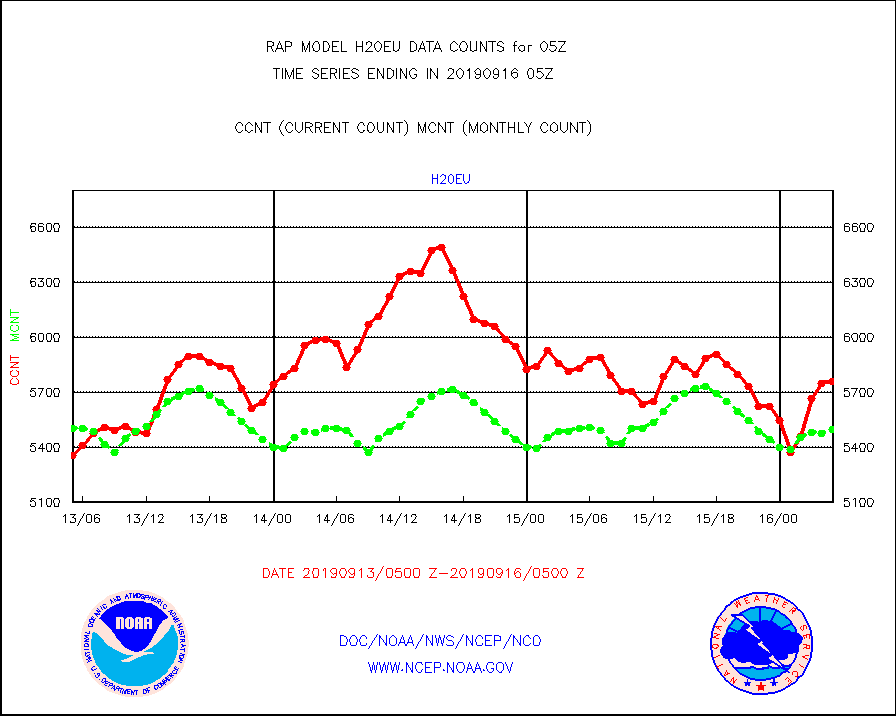
h20eu |
METEOSAT/EUMETSAT wvpr imager derived cld motion |
5758 |
5496 |
104.8 % |
1603.50-1606.49 |
h20ja |
MTSAT/JMA water vapor imager derived cloud motion |
2957 |
2638 |
112.1 % |
1602.50-1607.50 |
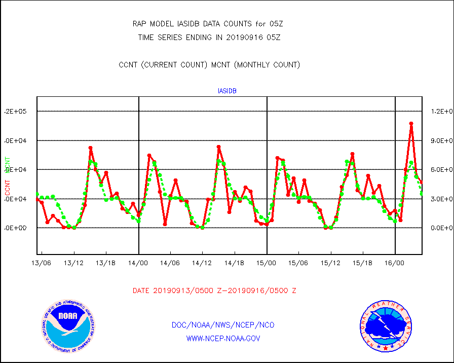
iasidb |
METOP 1-2 IASI 1C radiances-direct broadcast SSEC |
47274 |
34978 |
135.2 % |
1603.00-1606.99 |
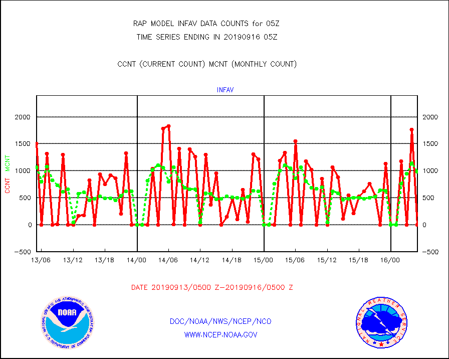
infav |
AVHRR (NOAA/METOP) ir lg-wave derived cld motion |
0 |
980 |
0.0 % |
1602.50-1607.50 |
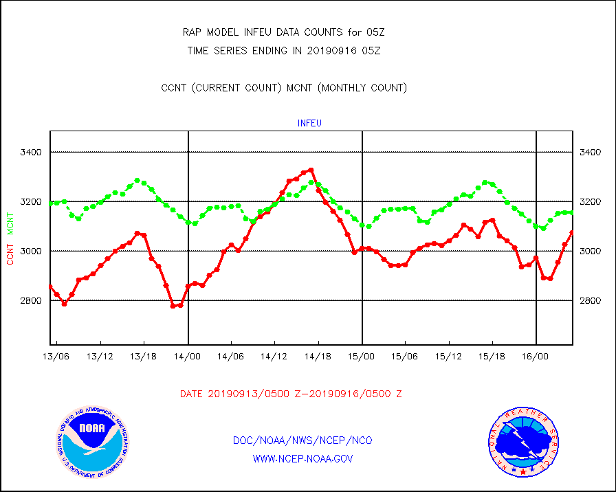
infeu |
METEOSAT/EUMETSAT ir lg-wave derived cloud motion |
3075 |
3156 |
97.4 % |
1603.50-1606.49 |
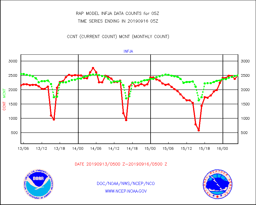
infja |
MTSAT/JMA infrared long-wave derived cloud motion |
2492 |
2494 |
99.9 % |
1602.50-1607.50 |
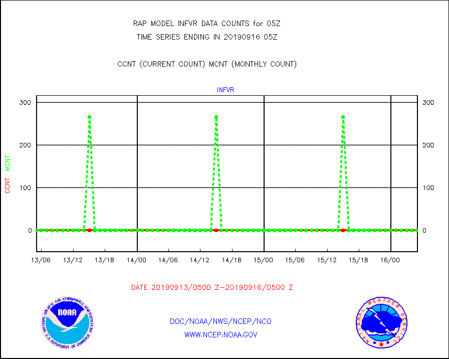
infvr |
VIIRS (NPP) infrared lg-wave derived cloud motion |
0 |
0 |
n/a |
1602.50-1607.50 |
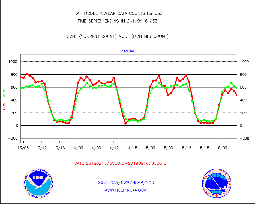
kamdar |
Korean AMDAR aircraft data (decoded from BUFR) |
475 |
595 |
79.8 % |
1601.75-1608.25 |
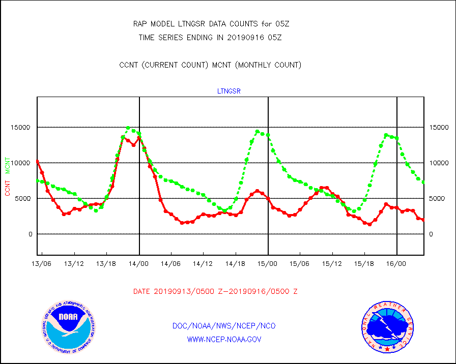
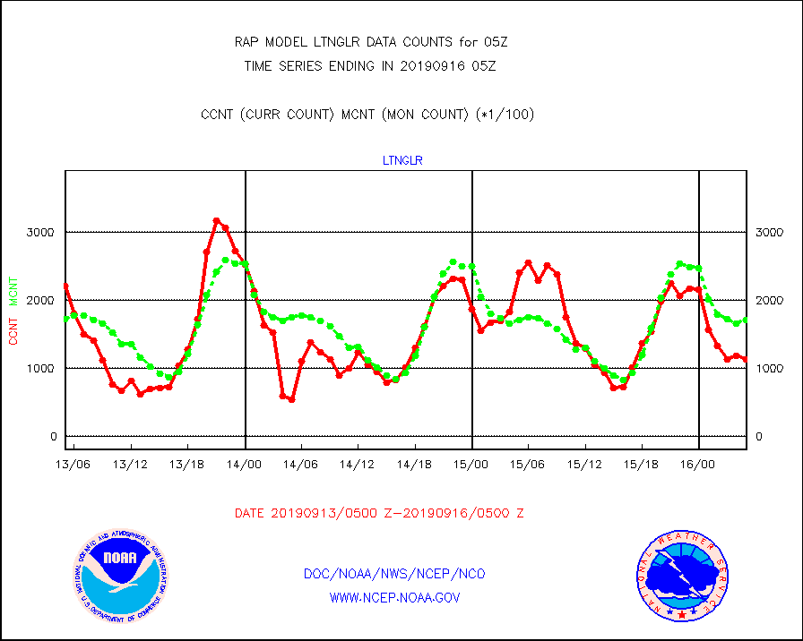
ltnglr |
LLDN Long-rng lightning from Vaisala via NOAAPORT |
113571 |
171354 |
66.3 % |
1604.00-1605.50 |
mso470 |
Mesonet/MADIS Colorado E-470 (Interstate 470) |
43 |
9 |
477.8 % |
1604.50-1605.50 |
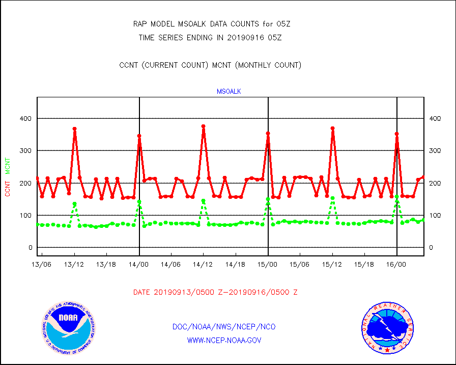
msoalk |
Mesonet/MADIS Alaska Department of Transportation |
218 |
86 |
253.5 % |
1604.50-1605.50 |
msoapg |
Mesonet/MADIS U.S. Army Aberdeen Proving Grounds |
0 |
0 |
n/a |
1604.50-1605.50 |
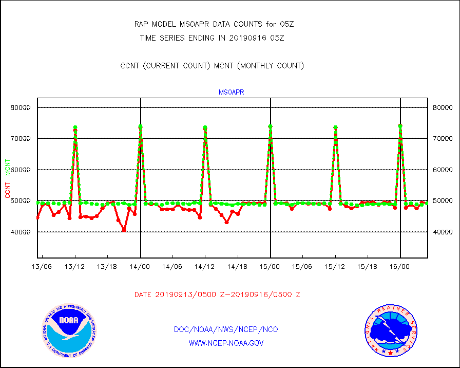
msoapr |
Mesonet/MADIS Citizen Weather Observers Program |
49197 |
49154 |
100.1 % |
1604.50-1605.50 |
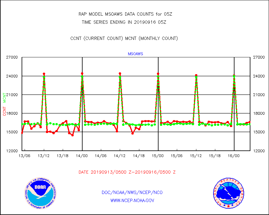
msoaws |
Mesonet/MADIS AWS Convergence Technologies, Inc. |
16584 |
16273 |
101.9 % |
1604.50-1605.50 |
msoawx |
Mesonet/MADIS "Anything Weather" |
0 |
0 |
n/a |
1604.50-1605.50 |
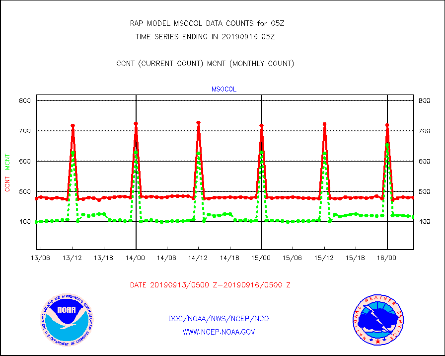
msocol |
Mesonet/MADIS Colorado Dept. of Transportation |
479 |
415 |
115.4 % |
1604.50-1605.50 |
msodcn |
Mesonet/MADIS DC Net |
0 |
0 |
n/a |
1604.50-1605.50 |
msoden |
Mesonet/MADIS Denver Urban Drainage & Flood Cntrl |
0 |
0 |
n/a |
1604.50-1605.50 |
msofla |
Mesonet/MADIS Florida (FAWN & USF) |
105 |
122 |
86.1 % |
1604.50-1605.50 |
msoflt |
Mesonet/MADIS Florida Dept. of Transportation |
0 |
0 |
n/a |
1604.50-1605.50 |
msogeo |
Mesonet/MADIS Georgia Dept. of Transportation |
249 |
48 |
518.8 % |
1604.50-1605.50 |
msohad |
Mesonet/MADIS NWS Hydromet Auto Data System(HADS) |
4357 |
4295 |
101.4 % |
1604.50-1605.50 |
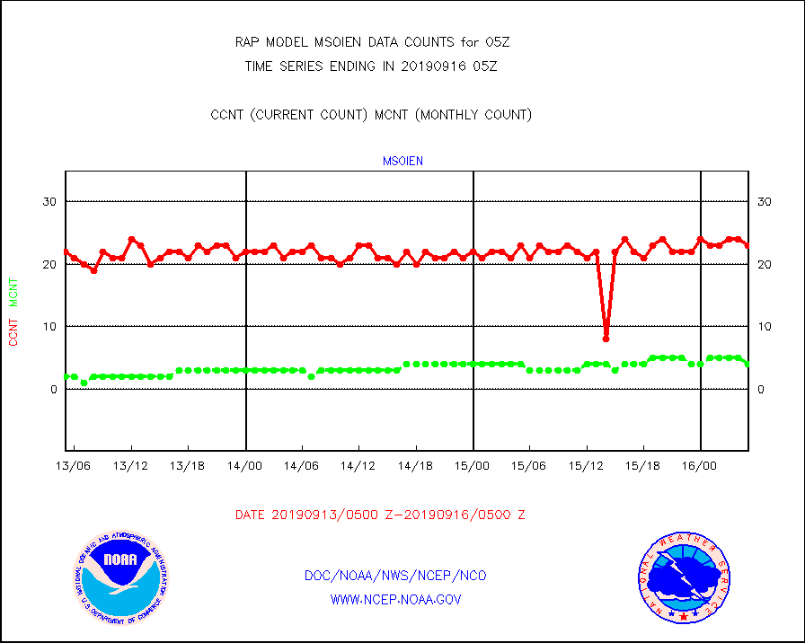
msoien |
Mesonet/MADIS Iowa Environmental |
23 |
4 |
575.0 % |
1604.50-1605.50 |
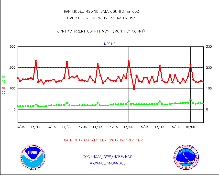
msoind |
Mesonet/MADIS Indiana Dept. of Transportation |
131 |
28 |
467.9 % |
1604.50-1605.50 |
msoiow |
Mesonet/MADIS Iowa Department of Transportation |
301 |
306 |
98.4 % |
1604.50-1605.50 |
msokan |
Mesonet/MADIS Kansas Department of Transportation |
317 |
317 |
100.0 % |
1604.50-1605.50 |
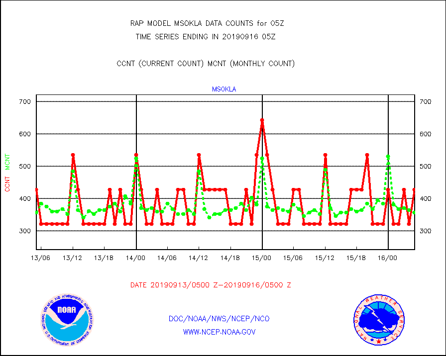
msokla |
Mesonet/MADIS Oklahoma Mesonet |
428 |
357 |
119.9 % |
1604.50-1605.50 |
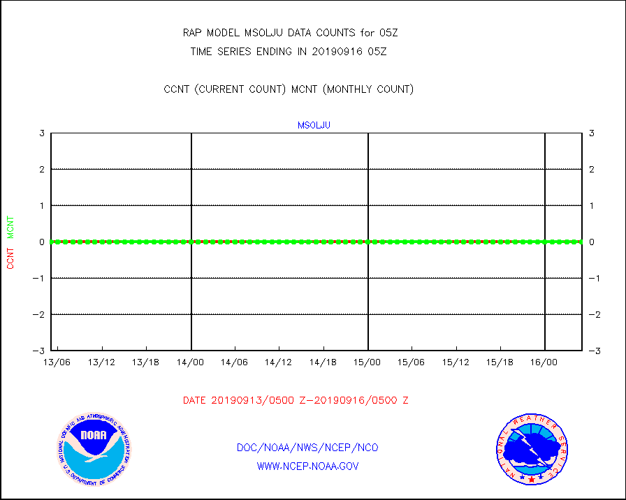
msolju |
Mesonet/MADIS Louisiana State/Jackson State Univ. |
0 |
0 |
n/a |
1604.50-1605.50 |
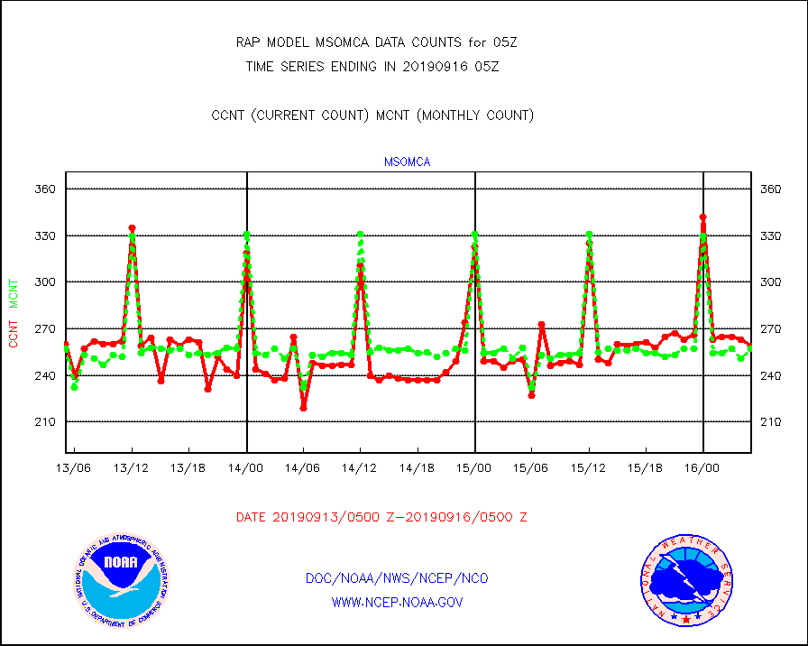
msomca |
Mesonet/MADIS Missouri Commercial Agricult Wx Net |
259 |
257 |
100.8 % |
1604.50-1605.50 |
msomin |
Mesonet/MADIS Minnesota Dept. of Transportation |
743 |
729 |
101.9 % |
1604.50-1605.50 |
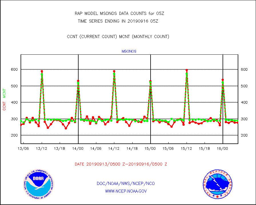
msonos |
Mesonet/MADIS NOS-Phys Oceanographic Realtime Sys |
277 |
289 |
95.8 % |
1604.50-1605.50 |
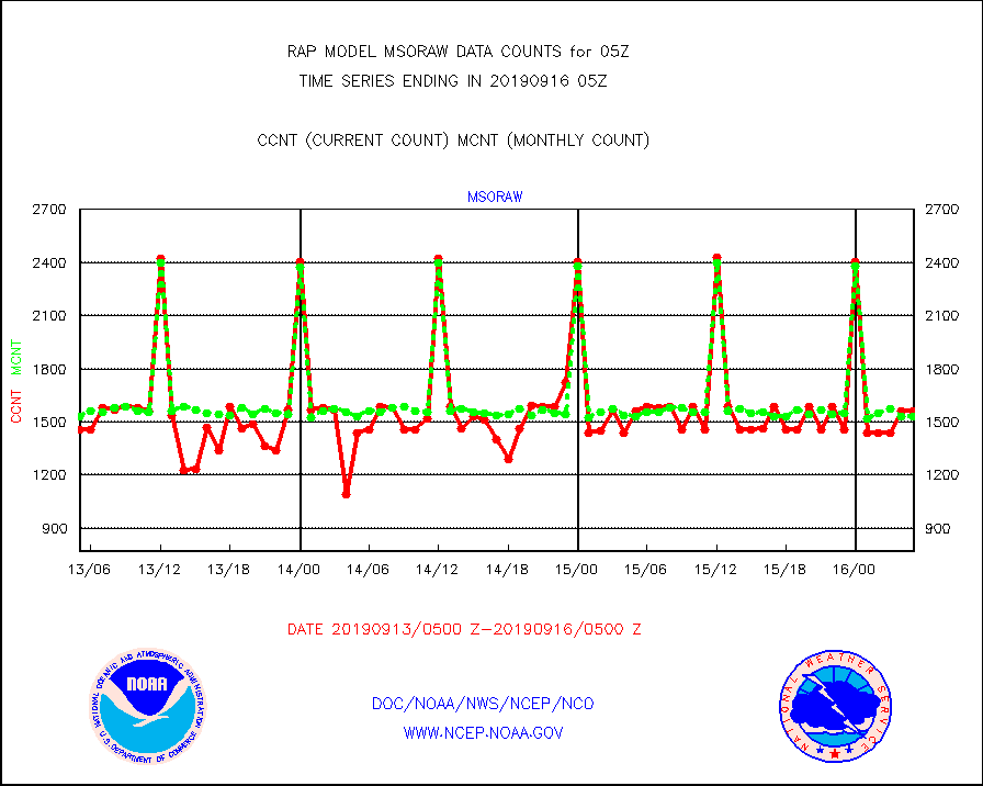
msoraw |
Mesonet/MADIS NFIC Remote Automated Wx Stns(RAWS) |
1563 |
1530 |
102.2 % |
1604.50-1605.50 |
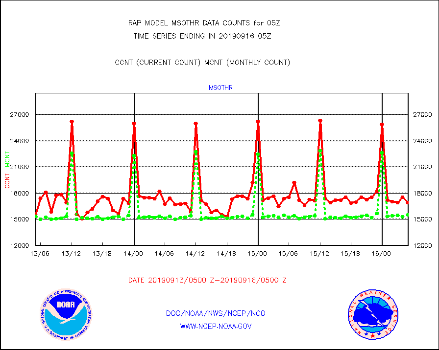
msothr |
Mesonet/MADIS many providers, not separated out |
16915 |
15527 |
108.9 % |
1604.50-1605.50 |
msovir |
Mesonet/MADIS Virginia Dept. of Transportation |
225 |
43 |
523.3 % |
1604.50-1605.50 |
msowfy |
Mesonet/MADIS "Weather for You" |
52 |
56 |
92.9 % |
1604.50-1605.50 |
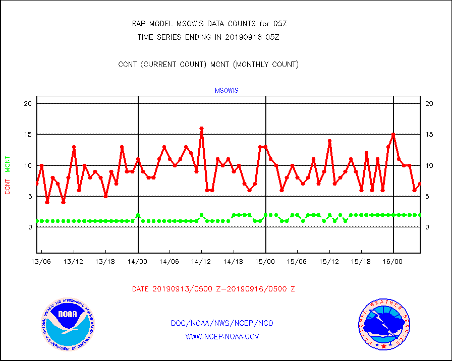
msowis |
Mesonet/MADIS Wisconsin Dept. of Transportation |
7 |
2 |
350.0 % |
1604.50-1605.50 |
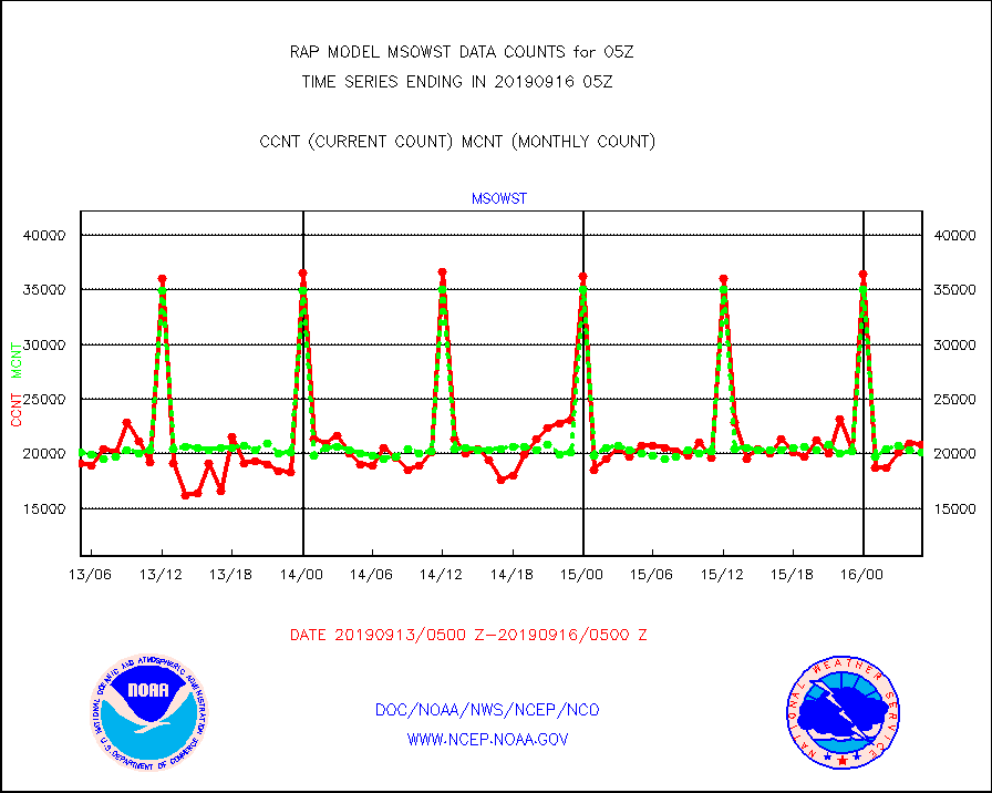
msowst |
Mesonet/MADIS MesoWest (many subproviders) |
20845 |
20101 |
103.7 % |
1604.50-1605.50 |
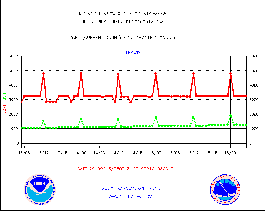
msowtx |
Mesonet/MADIS West Texas |
3235 |
1274 |
253.9 % |
1604.50-1605.50 |
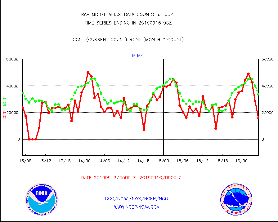
mtiasi |
METOP 1-2 IASI 1C radiance data (varbl. channels) |
15712 |
33732 |
46.6 % |
1603.00-1606.99 |
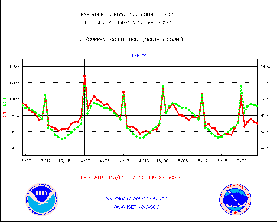
nxrdw2 |
NEXRAD Vel Azm Dsp(VAD) winds via Level 2 decoder |
702 |
914 |
76.8 % |
1604.00-1606.00 |
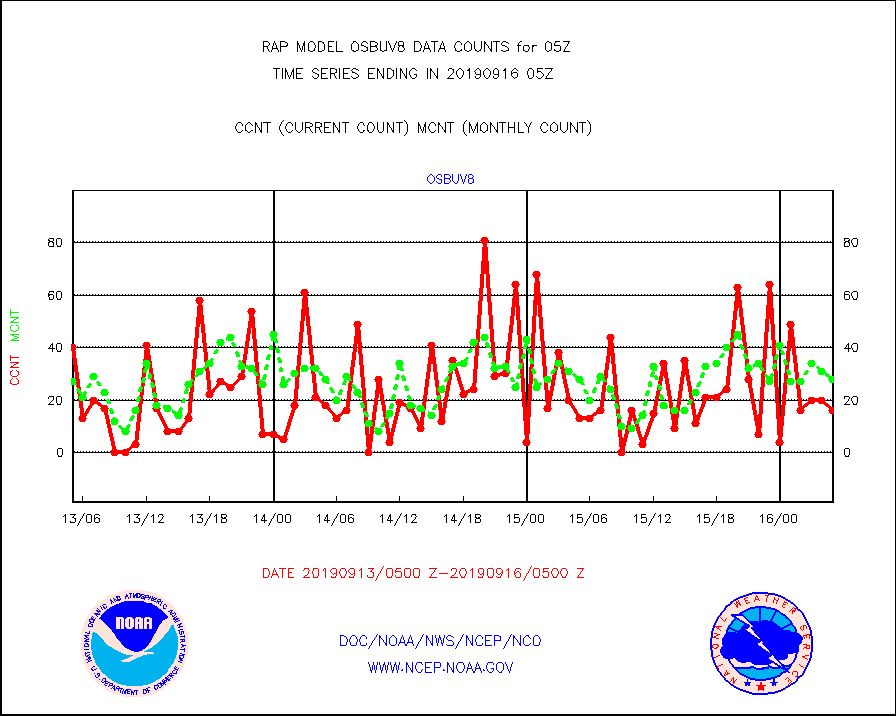
osbuv8 |
NOAA 16-19 Solar Backscatter UV-2 rad frm V8 BUFR |
16 |
28 |
57.1 % |
1603.00-1605.99 |
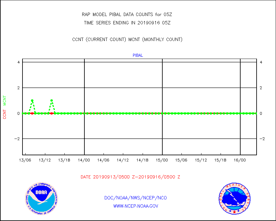
pibal |
PIBAL (from PILOT, PILOT SHIP, PILOT MOBIL) |
0 |
0 |
n/a |
1604.00-1606.00 |
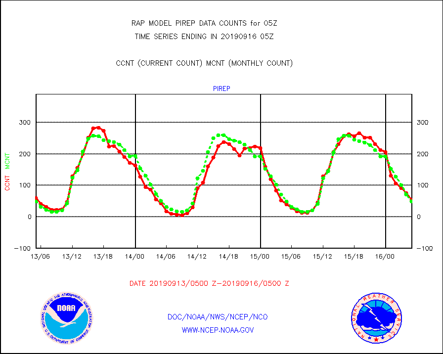
pirep |
Manual PIREP aircraft data (dcded from AIREP fmt) |
54 |
48 |
112.5 % |
1601.75-1608.25 |
prflrp |
Profilr winds from PIBAL (PILOT,PILOT SHIP/MOBIL) |
0 |
0 |
n/a |
1603.50-1606.50 |
radw25 |
NEXRAD radial wind superobs (Level 2.5 - ORPG) |
0 |
0 |
n/a |
1604.00-1606.00 |
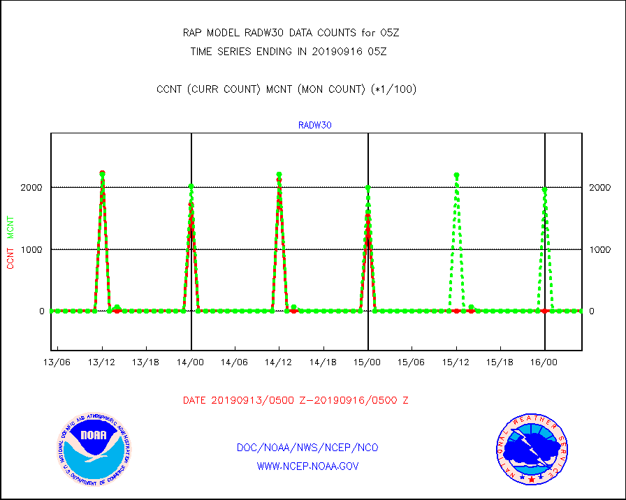
radw30 |
NEXRAD radial wind superobs (Level 3 - NIDS) |
0 |
0 |
n/a |
1604.00-1606.00 |
raobm |
Rawinsonde - mobile land (from TEMP/PILOT MOBIL) |
0 |
0 |
n/a |
1604.00-1606.00 |
raobs |
Rawinsonde - ship (from TEMP SHIP, PILOT SHIP) |
0 |
0 |
n/a |
1604.00-1606.00 |
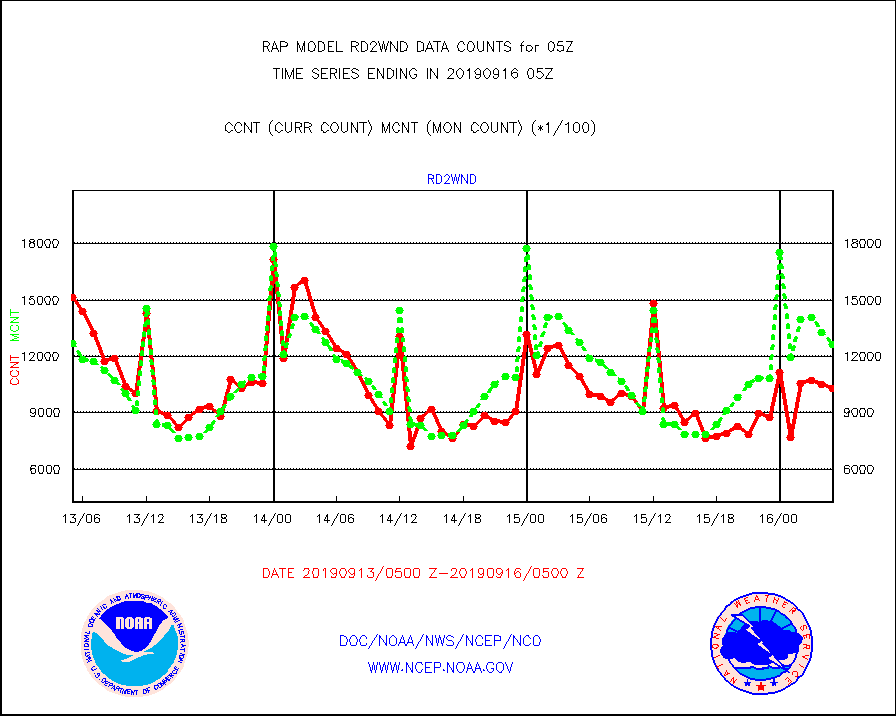
rd2wnd |
NEXRAD radial wind (Level 2 - GTS) |
1029183 |
1262956 |
81.5 % |
1604.50-1605.49 |
recco |
Flight level reconnaissance aircraft data |
0 |
1 |
0.0 % |
1604.00-1606.00 |
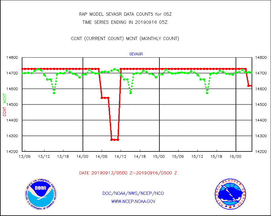
sevasr |
METEOSAT-10 2nd Gen SEVIRI All Sky Radiance(proc) |
14619 |
14707 |
99.4 % |
1603.00-1606.99 |
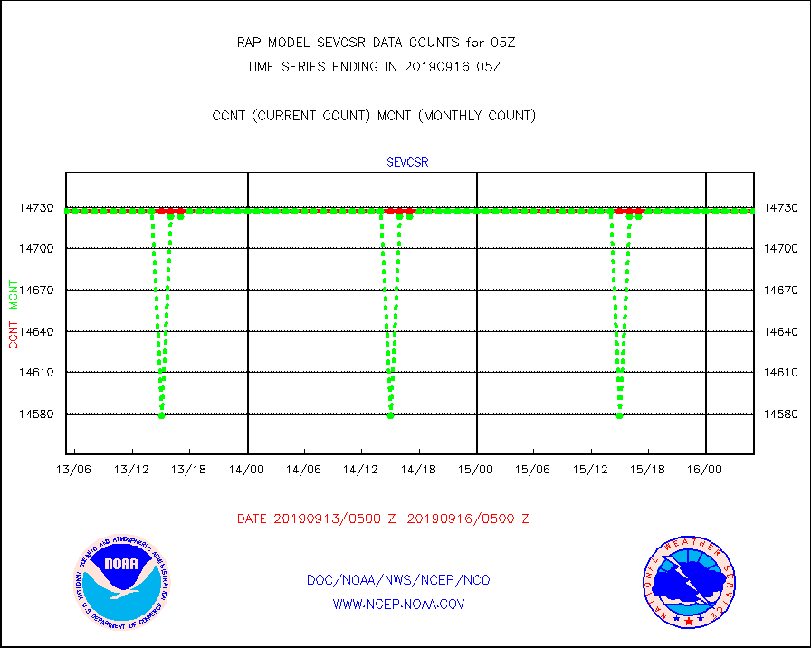
sevcsr |
METEOSAT-10 2nd Gen SEVIRI Clr Sky Radiance(proc) |
14727 |
14727 |
100.0 % |
1603.00-1606.99 |
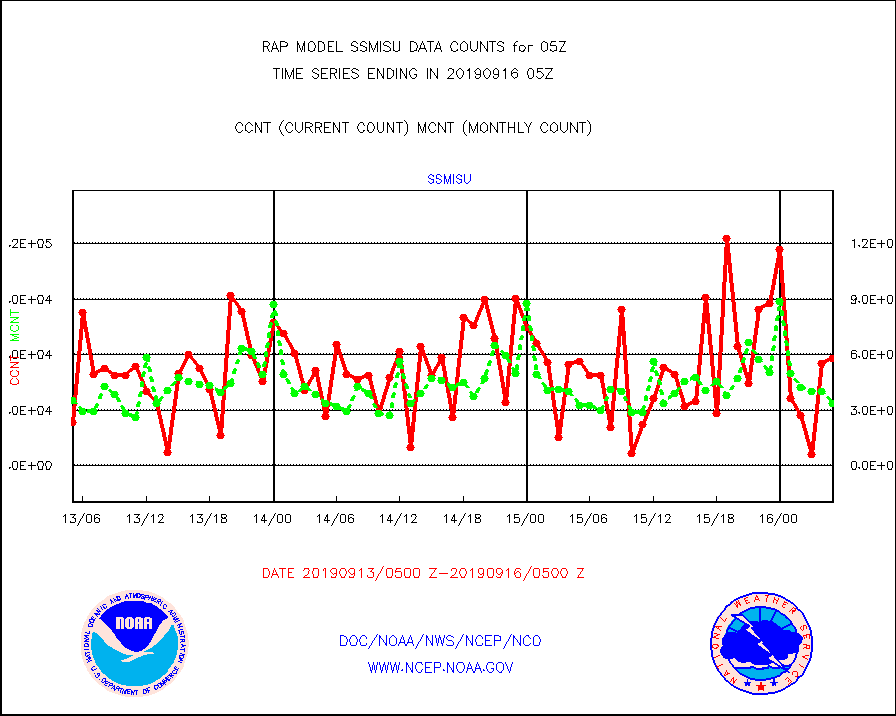
ssmisu |
DMSP SSM/IS 1C radiance data (Unified Pre-Proc.) |
58097 |
33408 |
173.9 % |
1603.00-1606.99 |
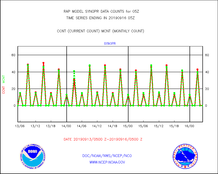
synopr |
Synoptic - restricted (WMO Res 40) manual & auto. |
0 |
0 |
n/a |
1604.50-1605.50 |
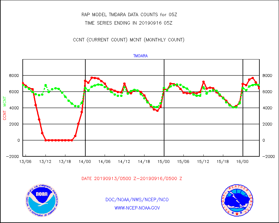
tmdara |
TAMDAR aircft data-all types(from Panasonic,BUFR) |
6404 |
6842 |
93.6 % |
1601.75-1608.25 |
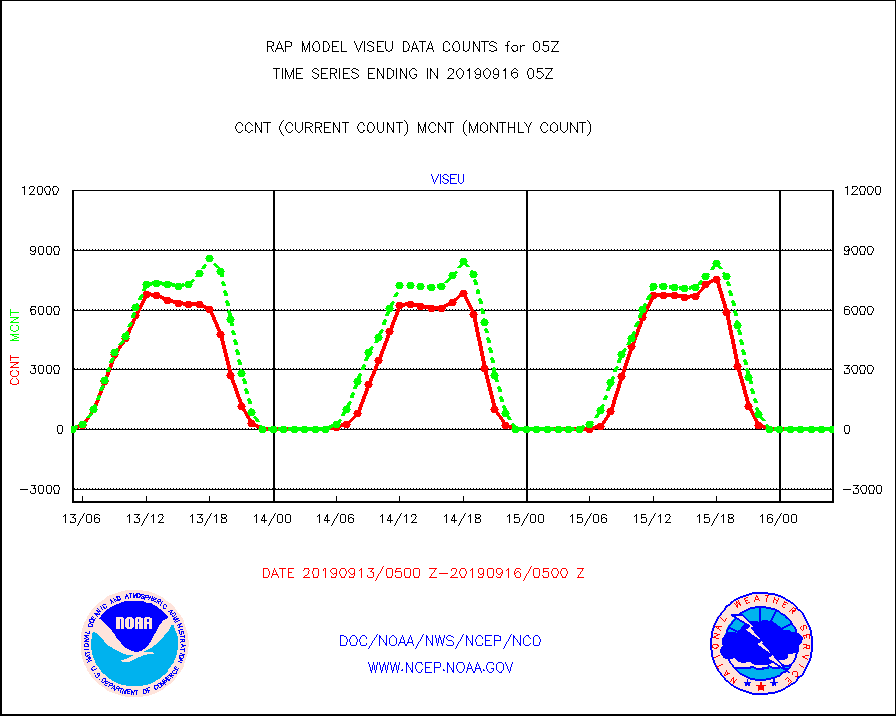
viseu |
METEOSAT/EUMETSAT visible derived cloud motion |
0 |
10 |
0.0 % |
1603.50-1606.49 |
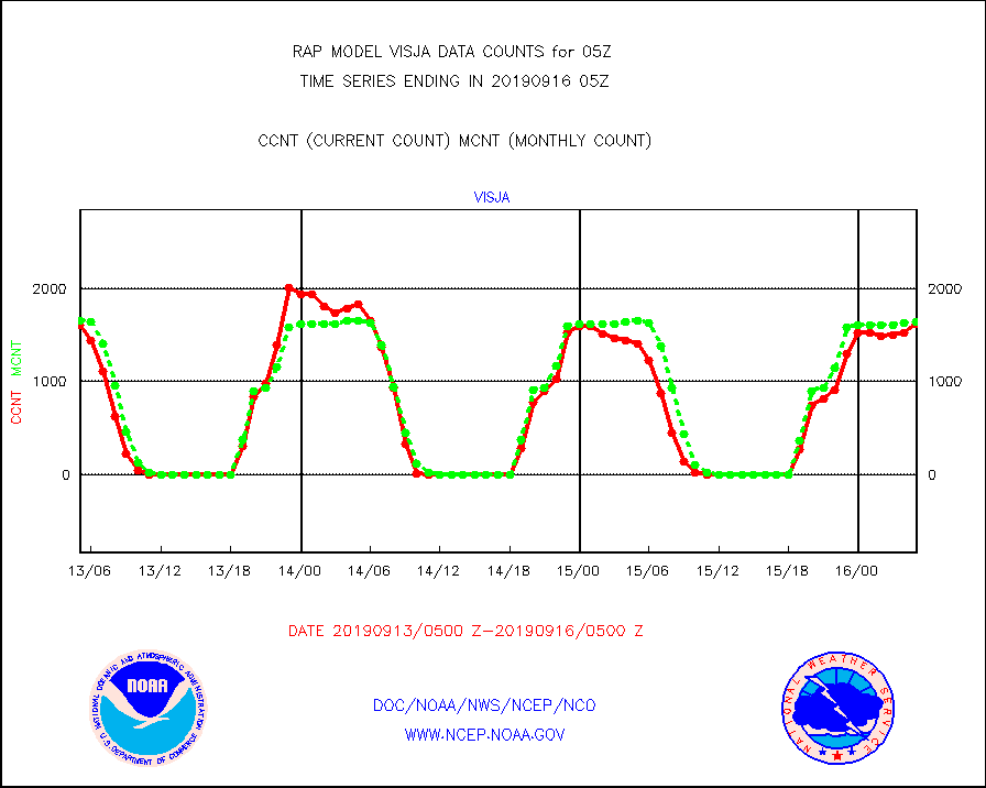
visja |
MTSAT/JMA visible derived cloud motion |
1626 |
1645 |
98.8 % |
1602.50-1607.50 |
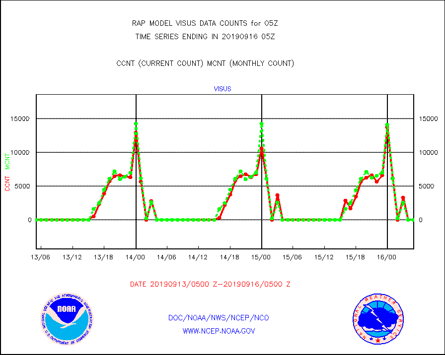
visus |
GOES/NESDIS visible derived cloud motion |
0 |
0 |
n/a |
1604.00-1604.99 |


