| Critical Data with Normal Counts |
|---|
| Type | Description | Hourly Count | Monthly Average | Percent (%) of Monthly Mean | UTC Time Window |
1bamua |
NOAA 15-19 & METOP 1-2 AMSU-A NCEP-proc. br.temps |
44785 |
47819 |
93.7 % |
1521.00-1602.99 |
1bhrs4 |
NOAA 18-19 & METOP 1-2 HIRS-4 NCEP-proc. br.temps |
81479 |
91741 |
88.8 % |
1521.00-1602.99 |
1bmhs |
NOAA 18-19 & METOP 1-2 MHS NCEP-proces. br. temps |
299691 |
304520 |
98.4 % |
1521.00-1602.99 |
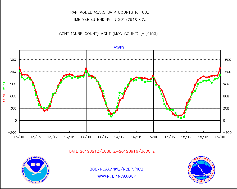
acars |
MDCRS ACARS acft data from ARINC(dcded from BUFR) |
129415 |
112755 |
114.8 % |
1520.75-1603.25 |
camdar |
Canadian AMDAR aircraft data (decoded from BUFR) |
898 |
890 |
100.9 % |
1520.75-1603.25 |
dbuoy |
Buoys decoded from FM-18 fmt (moored or drifting) |
48 |
46 |
104.3 % |
1523.50-1600.50 |
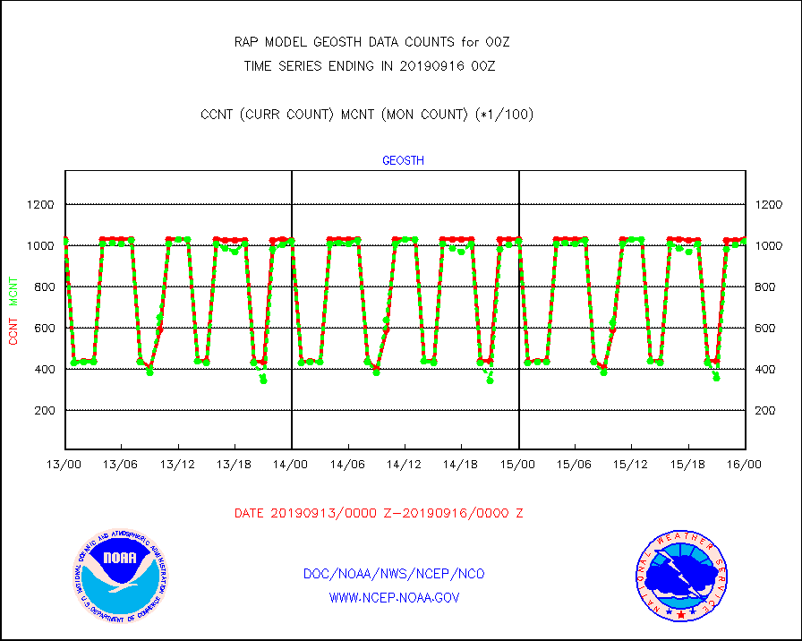
geosth |
GOES/NESDIS hi-resol. (1x1 f-o-v) cloud data |
102818 |
102289 |
100.5 % |
1522.75-1523.99 |
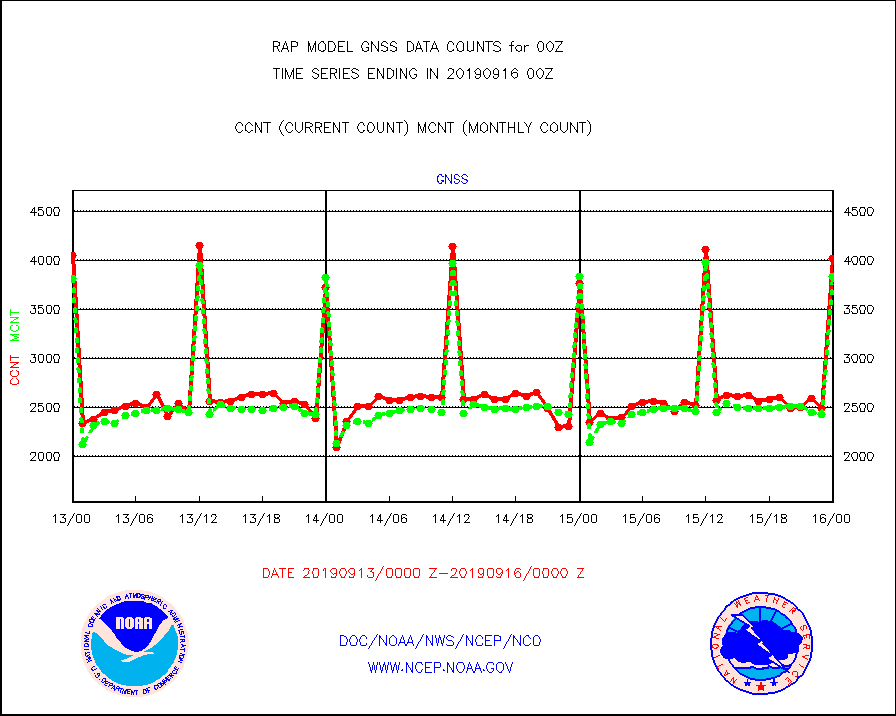
gnss |
Grnd-based Gbl Navigation Sat System (GNSS) data |
4020 |
3842 |
104.6 % |
1522.95-1523.05 |
h20mo |
MODIS (AQUA/TERRA) wvpr imager derived cld motion |
0 |
0 |
n/a |
1522.50-1601.50 |
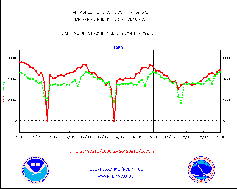
h2ius |
GOES/NESDIS water vapor imager derived cld motion |
4903 |
4717 |
103.9 % |
1523.00-1523.99 |
infmo |
MODIS (AQUA/TERRA) ir l-wave derived cloud motion |
0 |
0 |
n/a |
1522.50-1601.50 |
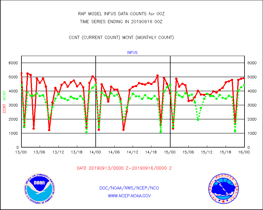
infus |
GOES/NESDIS infrared lg-wave derived cloud motion |
4900 |
4404 |
111.3 % |
1523.00-1523.99 |
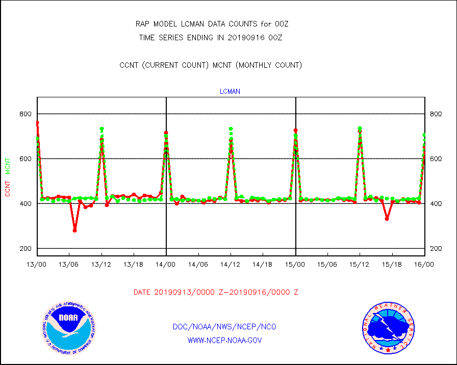
lcman |
Land-based CMAN stations decoded from CMAN format |
654 |
708 |
92.4 % |
1523.50-1600.50 |
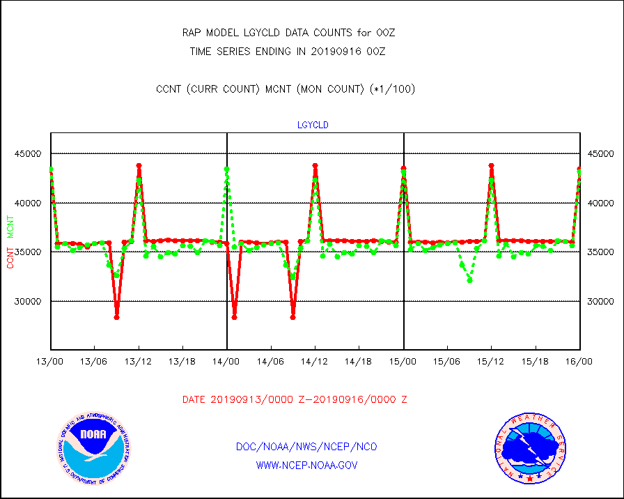
lgycld |
GOES/NASA(Langley) hi-res. (1x1 f-o-v) cloud data |
4347672 |
4318575 |
100.7 % |
1523.50-1600.50 |
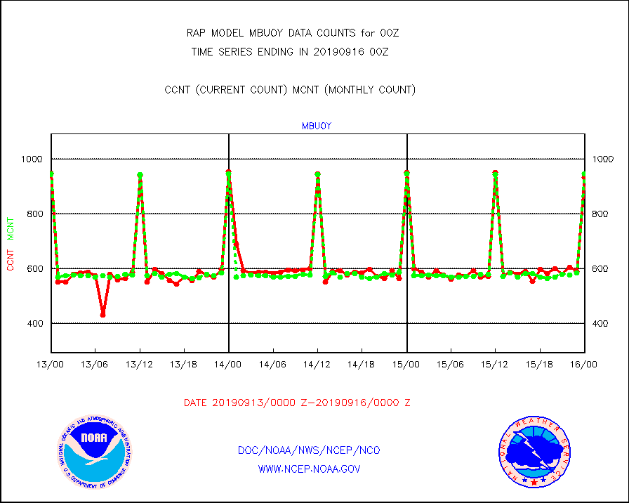
mbuoy |
Buoys decoded from FM-13 format (moored) |
935 |
947 |
98.7 % |
1523.50-1600.50 |
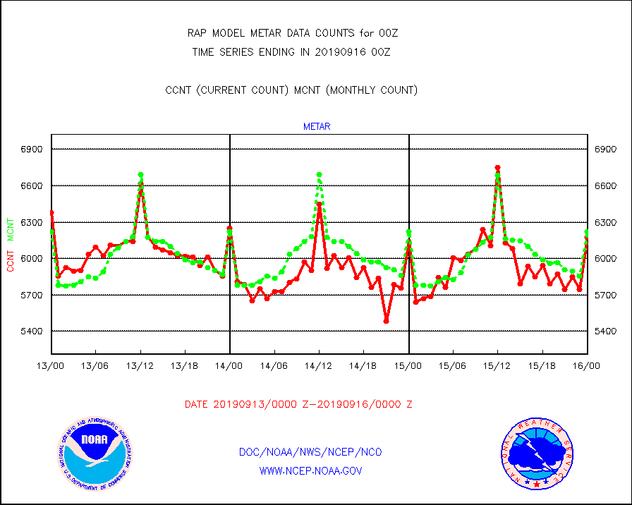
metar |
Aviation - METAR |
6173 |
6221 |
99.2 % |
1523.50-1600.50 |
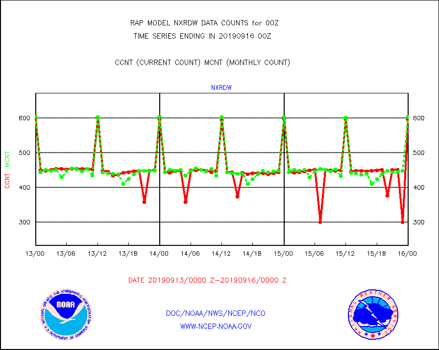
nxrdw |
NEXRAD Vel Azm Dsp(VAD) winds via radar coded msg |
596 |
603 |
98.8 % |
1523.00-1601.00 |
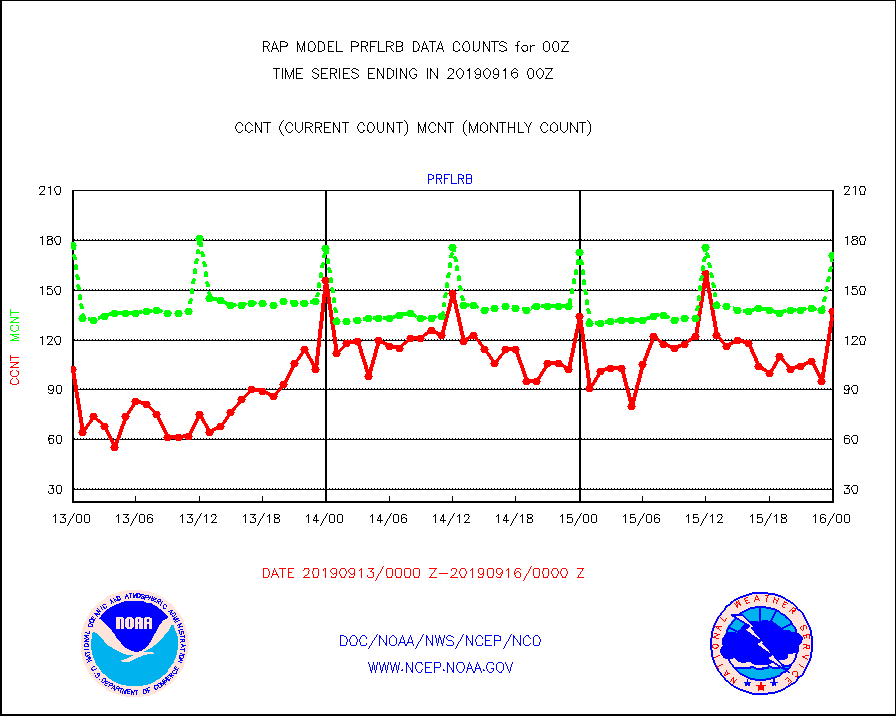
prflrb |
Multi-Agency Profiler (MAP) and SODAR winds |
137 |
171 |
80.1 % |
1522.50-1601.50 |
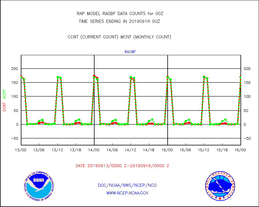
raobf |
Rawinsonde - fixed land (from TEMP or PILOT) |
171 |
169 |
101.2 % |
1523.00-1601.00 |
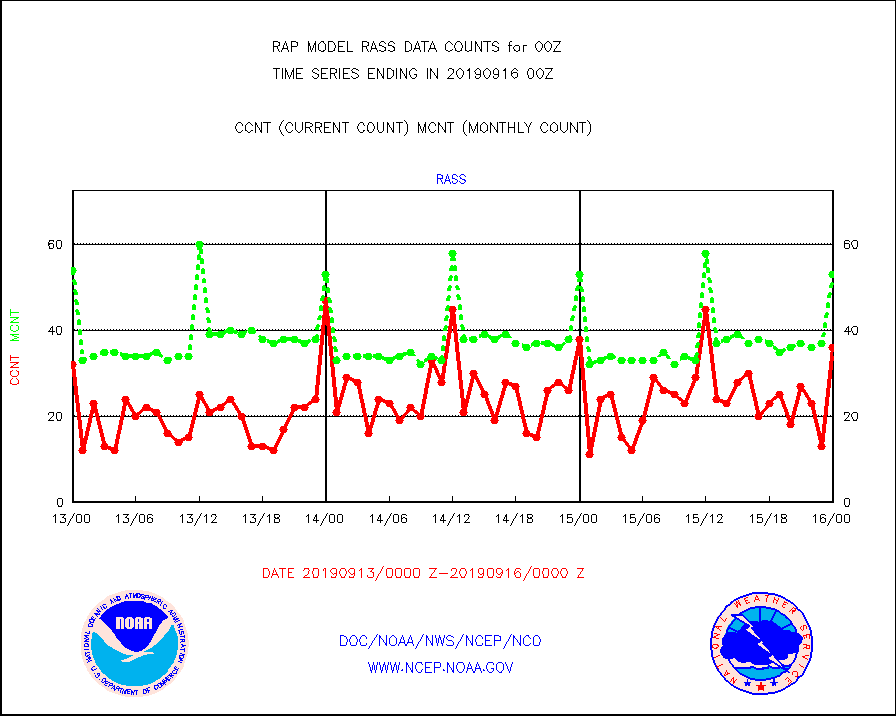
rass |
RASS temperatures (NOAA and Multi-Agency) |
36 |
53 |
67.9 % |
1523.50-1600.50 |
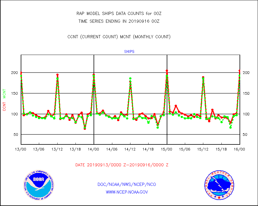
ships |
Ship - manual and automatic, restricted |
205 |
193 |
106.2 % |
1523.50-1600.50 |
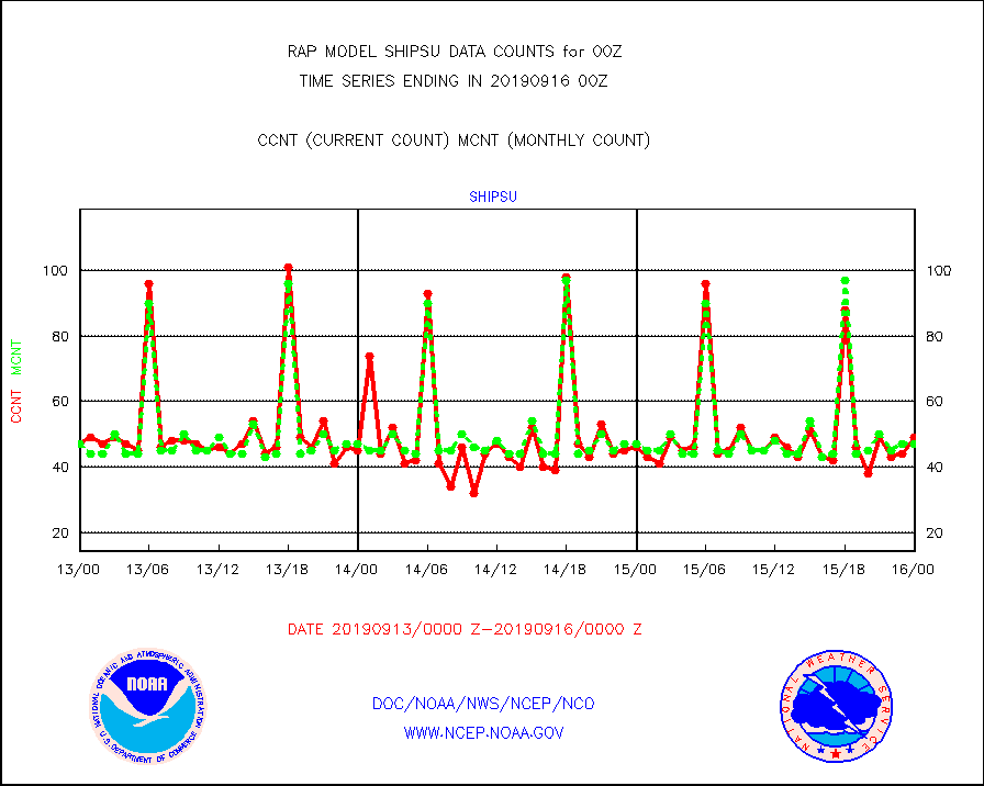
shipsu |
Ship - manual and automatic, unrestricted |
49 |
47 |
104.3 % |
1523.50-1600.50 |
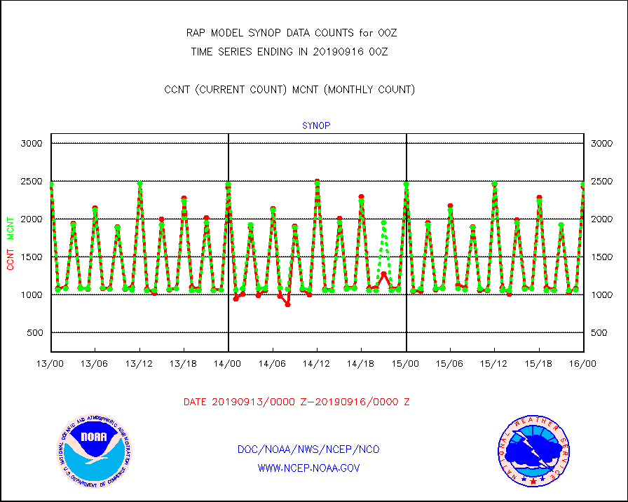
synop |
Synoptic - fixed manual and automatic |
2426 |
2455 |
98.8 % |
1523.50-1600.50 |
tideg |
Tide gauge reports decoded from CREX format |
714 |
743 |
96.1 % |
1523.50-1600.50 |
| Data Types of Opportunity with Normal Counts |
|---|
| Type | Description | Hourly Count | Monthly Average | Percent (%) of Monthly Mean | UTC Time Window |
3p9us |
GOES/NESDIS infrared shrt-wave derived cld motion |
12351 |
9711 |
127.2 % |
1523.00-1523.99 |
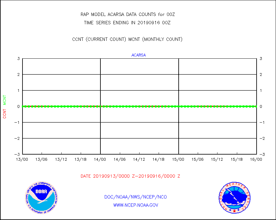
acarsa |
MDCRS ACARS acft data (ARINC via AFWA)(AIREP fmt) |
0 |
0 |
n/a |
1520.75-1603.25 |
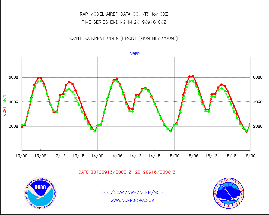
airep |
Manual AIREP aircraft data (dcded from AIREP fmt) |
2150 |
2082 |
103.3 % |
1520.75-1603.25 |
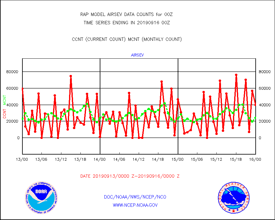
airsev |
AQUA AIRS/AMSU-A/HSB brightness temps- every FOV |
39955 |
24222 |
165.0 % |
1521.00-1602.99 |
amdar |
AMDAR aircraft data (decoded from AMDAR format) |
3152 |
2656 |
118.7 % |
1520.75-1603.25 |
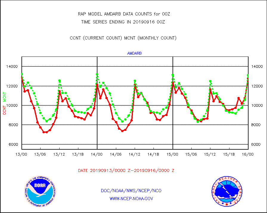
amdarb |
AMDAR aircraft data (decoded from BUFR) |
12788 |
13112 |
97.5 % |
1520.75-1603.25 |
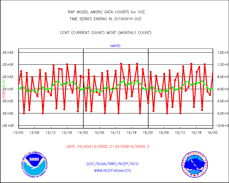
amsr2 |
GCOM-W AMSR2 1B brightness temperatures |
975737 |
600117 |
162.6 % |
1521.00-1521.99 |
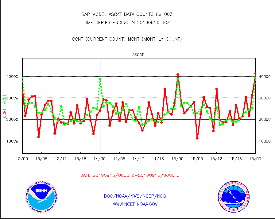
ascat |
METOP 1-2 ASCAT products |
41431 |
39204 |
105.7 % |
1522.00-1602.00 |
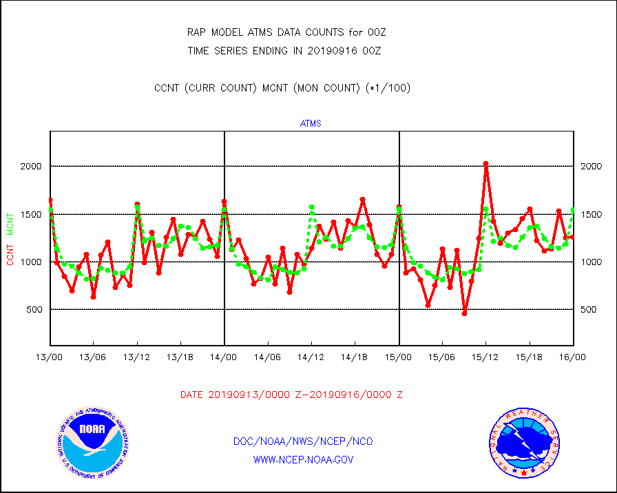
atms |
NPP Adv. Tech. Microwave Sounder (ATMS) br. temps |
126137 |
155003 |
81.4 % |
1522.00-1601.99 |
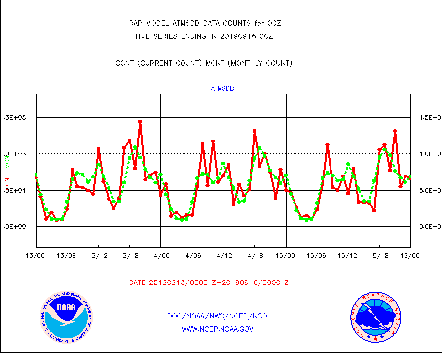
atmsdb |
NPP Adv Tech MW Sndr(ATMS) b. temps-dir bcst SSEC |
66791 |
69598 |
96.0 % |
1522.00-1601.99 |
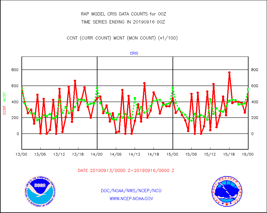
cris |
NPP Cross-track Infrared Sounder (CrIS) radiances |
49278 |
55779 |
88.3 % |
1522.00-1601.99 |
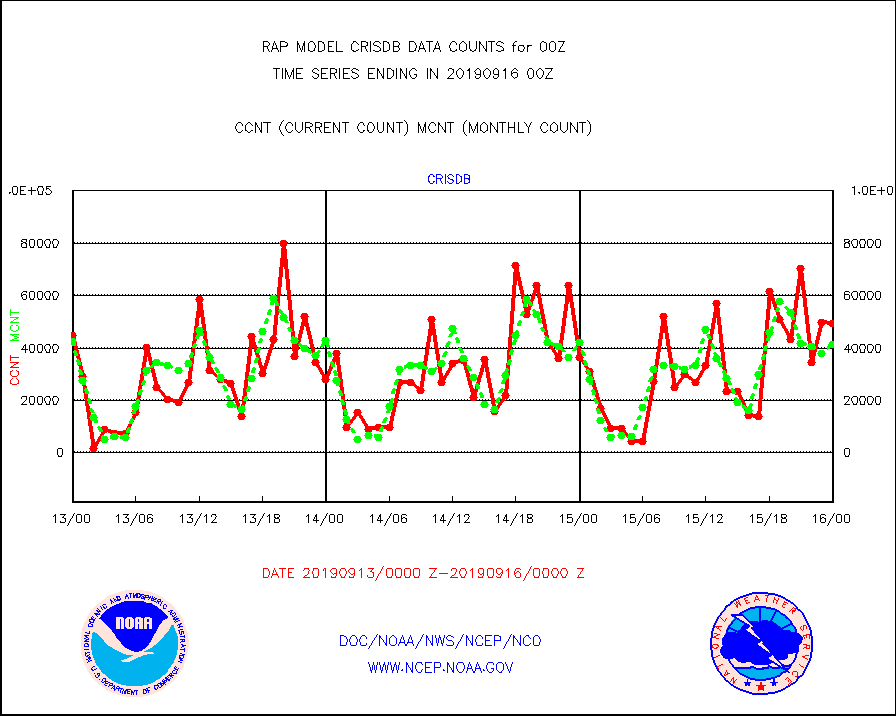
crisdb |
NPP Crss-trk IR Sndr(CrIS) radiance-dir bcst SSEC |
49370 |
41554 |
118.8 % |
1522.00-1601.99 |
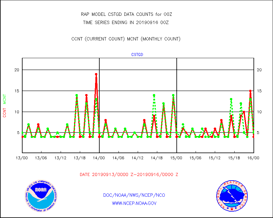
cstgd |
Coast Guard |
4 |
5 |
80.0 % |
1523.50-1600.50 |
dropw |
Dropwinsonde (from TEMP DROP) |
7 |
6 |
116.7 % |
1523.00-1601.00 |
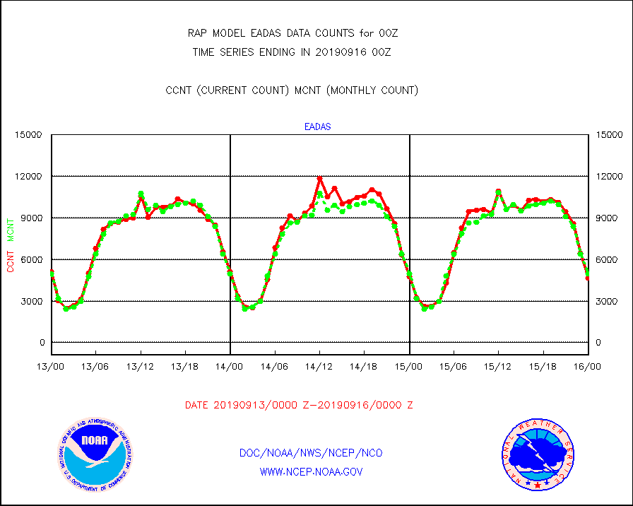
eadas |
E-AMDAR (European AMDAR acft decoded from BUFR) |
4685 |
4971 |
94.2 % |
1520.75-1603.25 |
esamua |
NOAA 15-19 & METOP 1-2 AMSU-A proc btmps frm RARS |
17096 |
16411 |
104.2 % |
1523.00-1601.00 |
esatms |
NPP Adv. Tech. MW Sndr (ATMS) br. temps from RARS |
39235 |
26828 |
146.2 % |
1522.00-1601.99 |
escris |
NPP Crss-track IR Sndr (CrIS) radiances from RARS |
11989 |
7824 |
153.2 % |
1522.00-1601.99 |
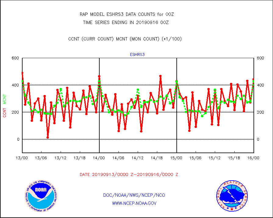
eshrs3 |
NOAA 15-19 & METOP 1-2 HIRS-3/4 pr btmps frm RARS |
44491 |
42938 |
103.6 % |
1523.00-1601.00 |
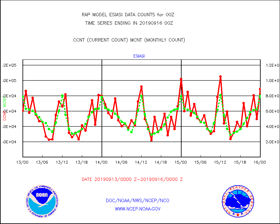
esiasi |
METOP 1-2 IASI 1C radiance data vbl chn from RARS |
88936 |
79880 |
111.3 % |
1522.00-1601.99 |
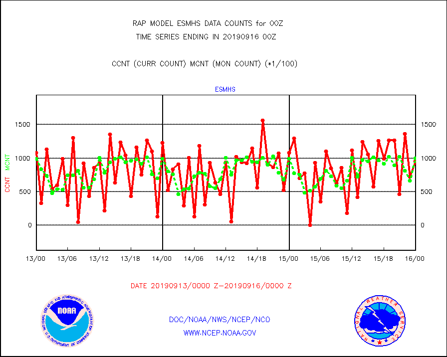
esmhs |
NOAA 18-19 & METOP 1-2 MHS proc. btemps from RARS |
95301 |
99935 |
95.4 % |
1523.00-1601.00 |
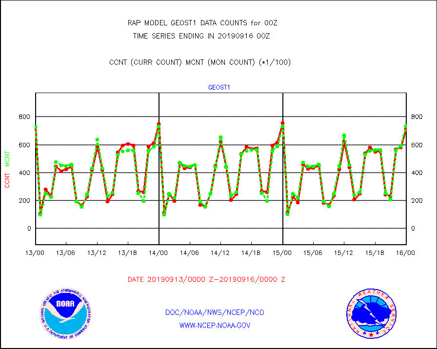
geost1 |
GOES/NESDIS hi-resol. (1x1 f-o-v) sndgs/radiances |
71474 |
73534 |
97.2 % |
1523.00-1601.00 |
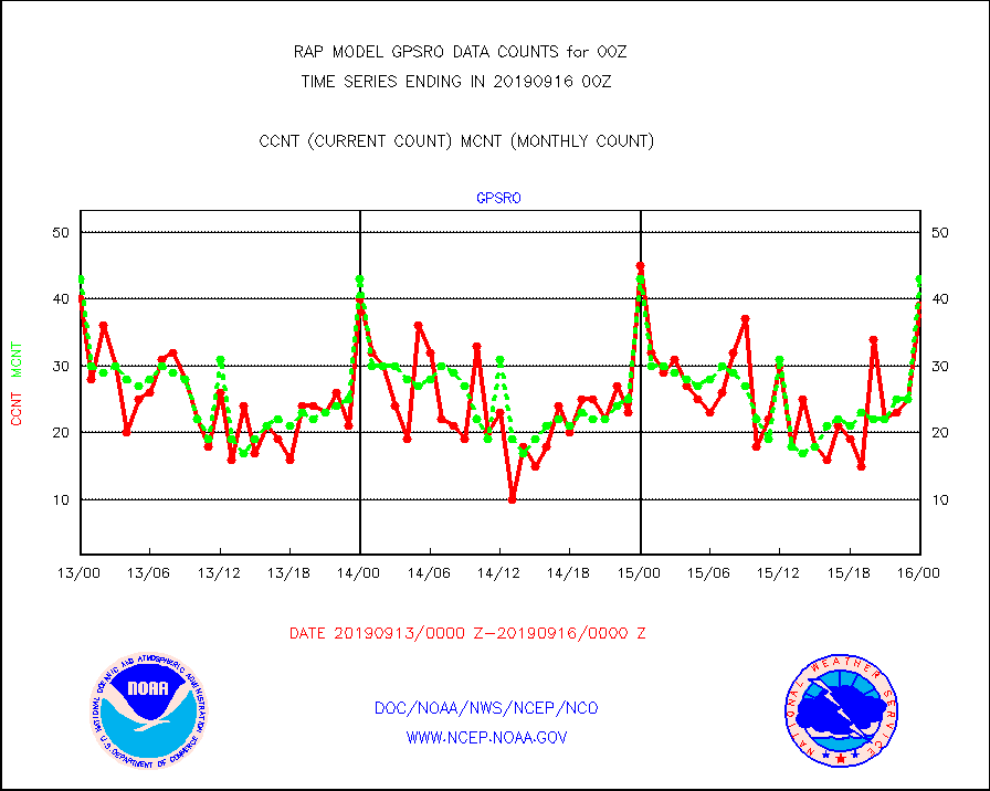
gpsro |
GPS radio occultation data |
39 |
43 |
90.7 % |
1522.00-1601.99 |
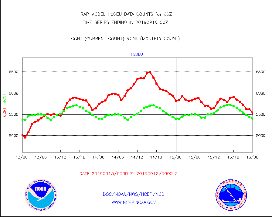
h20eu |
METEOSAT/EUMETSAT wvpr imager derived cld motion |
5544 |
5398 |
102.7 % |
1522.50-1601.49 |
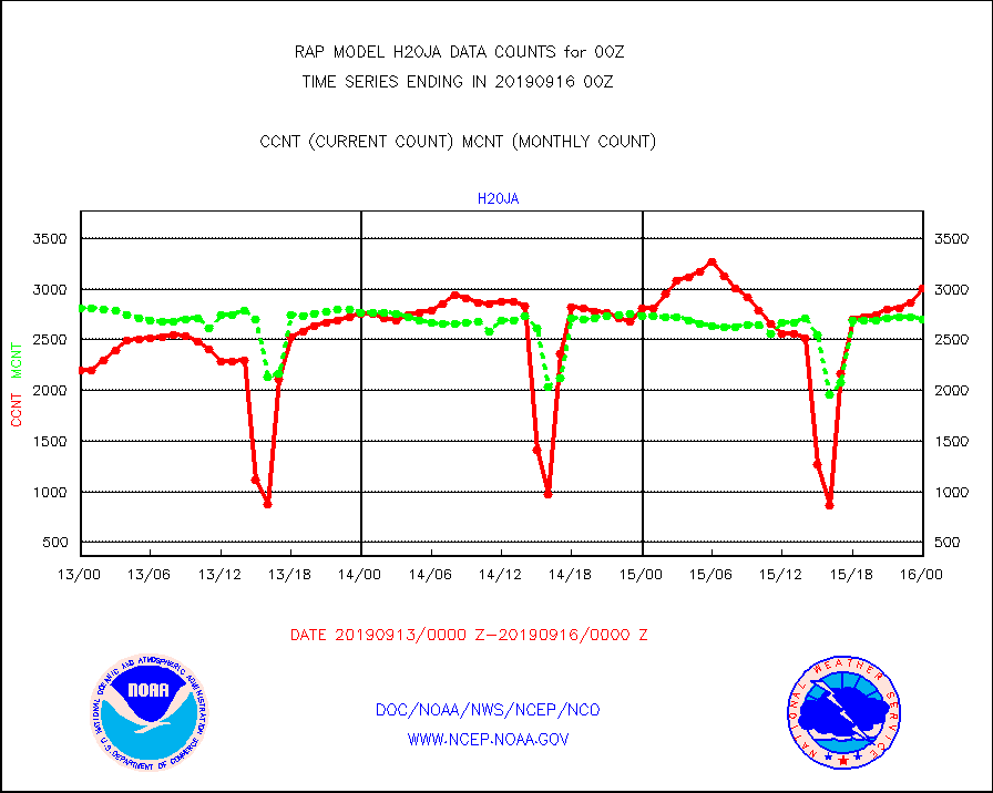
h20ja |
MTSAT/JMA water vapor imager derived cloud motion |
3004 |
2702 |
111.2 % |
1522.50-1601.50 |
iasidb |
METOP 1-2 IASI 1C radiances-direct broadcast SSEC |
17535 |
6905 |
253.9 % |
1522.00-1601.99 |
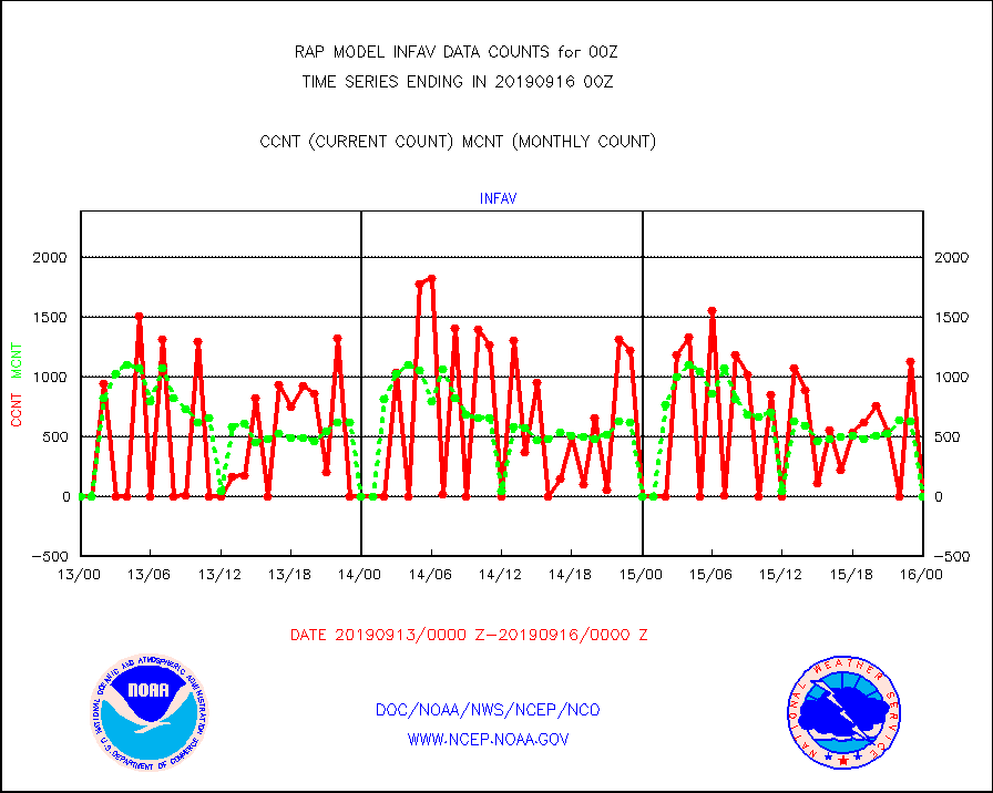
infav |
AVHRR (NOAA/METOP) ir lg-wave derived cld motion |
0 |
0 |
n/a |
1522.50-1601.50 |
infeu |
METEOSAT/EUMETSAT ir lg-wave derived cloud motion |
2972 |
3100 |
95.9 % |
1522.50-1601.49 |
infja |
MTSAT/JMA infrared long-wave derived cloud motion |
2403 |
2369 |
101.4 % |
1522.50-1601.50 |
infvr |
VIIRS (NPP) infrared lg-wave derived cloud motion |
0 |
0 |
n/a |
1522.50-1601.50 |
kamdar |
Korean AMDAR aircraft data (decoded from BUFR) |
480 |
521 |
92.1 % |
1520.75-1603.25 |
ltnglr |
LLDN Long-rng lightning from Vaisala via NOAAPORT |
216328 |
247376 |
87.4 % |
1523.00-1600.50 |
mso470 |
Mesonet/MADIS Colorado E-470 (Interstate 470) |
65 |
13 |
500.0 % |
1523.50-1600.50 |
msoalk |
Mesonet/MADIS Alaska Department of Transportation |
353 |
159 |
222.0 % |
1523.50-1600.50 |
msoapg |
Mesonet/MADIS U.S. Army Aberdeen Proving Grounds |
0 |
0 |
n/a |
1523.50-1600.50 |
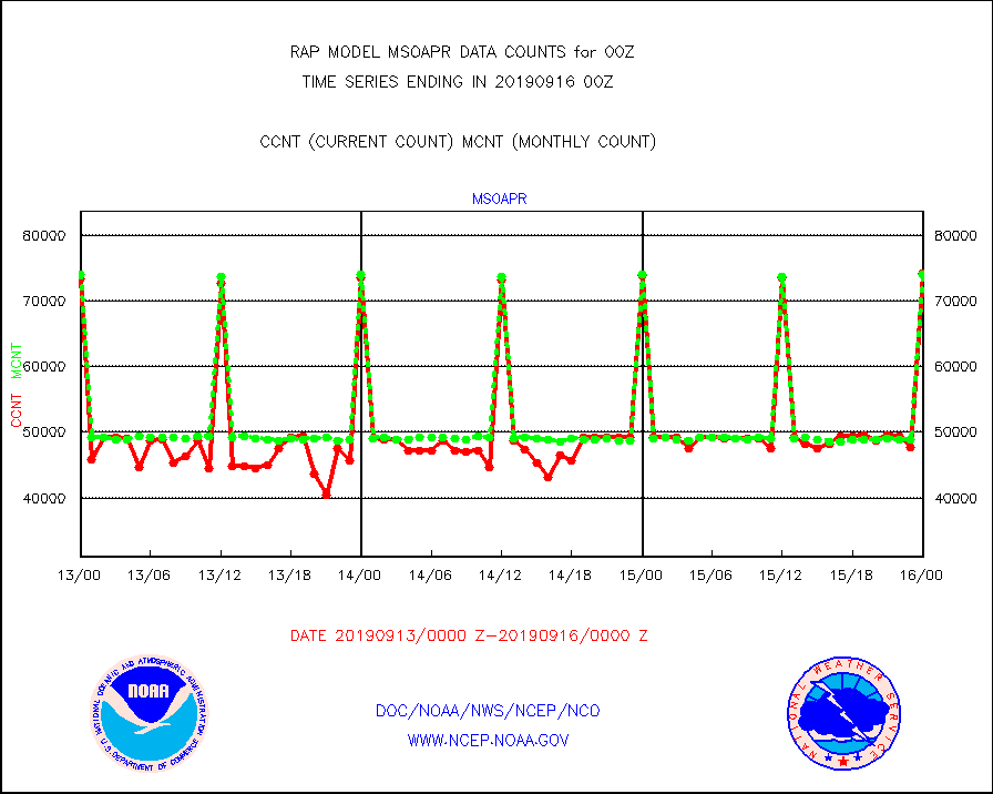
msoapr |
Mesonet/MADIS Citizen Weather Observers Program |
74148 |
74057 |
100.1 % |
1523.50-1600.50 |
msoaws |
Mesonet/MADIS AWS Convergence Technologies, Inc. |
24057 |
23957 |
100.4 % |
1523.50-1600.50 |
msoawx |
Mesonet/MADIS "Anything Weather" |
0 |
0 |
n/a |
1523.50-1600.50 |
msocol |
Mesonet/MADIS Colorado Dept. of Transportation |
720 |
653 |
110.3 % |
1523.50-1600.50 |
msodcn |
Mesonet/MADIS DC Net |
0 |
0 |
n/a |
1523.50-1600.50 |
msoden |
Mesonet/MADIS Denver Urban Drainage & Flood Cntrl |
0 |
0 |
n/a |
1523.50-1600.50 |
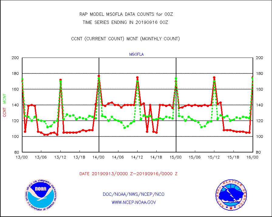
msofla |
Mesonet/MADIS Florida (FAWN & USF) |
175 |
174 |
100.6 % |
1523.50-1600.50 |
msoflt |
Mesonet/MADIS Florida Dept. of Transportation |
0 |
0 |
n/a |
1523.50-1600.50 |
msogeo |
Mesonet/MADIS Georgia Dept. of Transportation |
357 |
72 |
495.8 % |
1523.50-1600.50 |
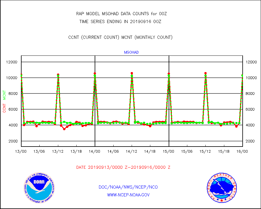
msohad |
Mesonet/MADIS NWS Hydromet Auto Data System(HADS) |
10325 |
10303 |
100.2 % |
1523.50-1600.50 |
msoien |
Mesonet/MADIS Iowa Environmental |
24 |
4 |
600.0 % |
1523.50-1600.50 |
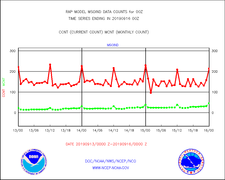
msoind |
Mesonet/MADIS Indiana Dept. of Transportation |
214 |
46 |
465.2 % |
1523.50-1600.50 |
msoiow |
Mesonet/MADIS Iowa Department of Transportation |
401 |
408 |
98.3 % |
1523.50-1600.50 |
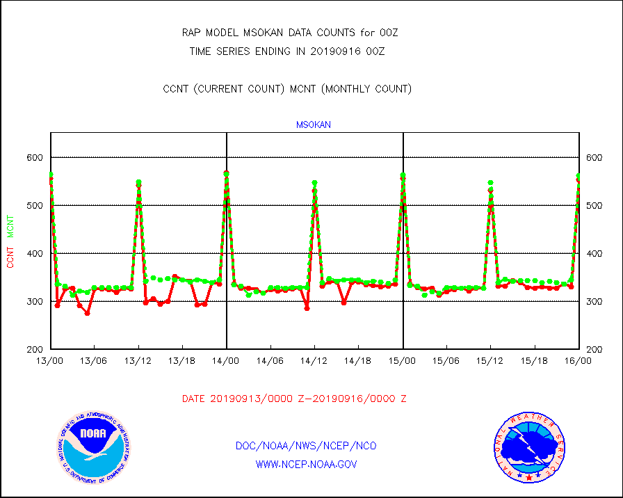
msokan |
Mesonet/MADIS Kansas Department of Transportation |
553 |
562 |
98.4 % |
1523.50-1600.50 |
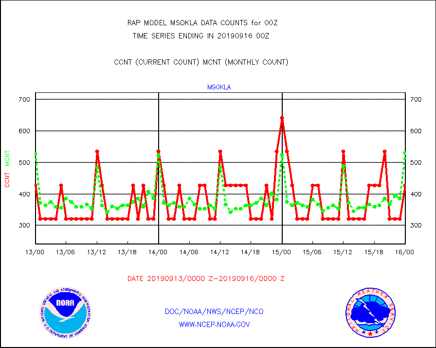
msokla |
Mesonet/MADIS Oklahoma Mesonet |
428 |
531 |
80.6 % |
1523.50-1600.50 |
msolju |
Mesonet/MADIS Louisiana State/Jackson State Univ. |
0 |
0 |
n/a |
1523.50-1600.50 |
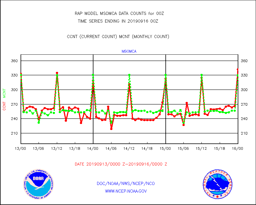
msomca |
Mesonet/MADIS Missouri Commercial Agricult Wx Net |
342 |
330 |
103.6 % |
1523.50-1600.50 |
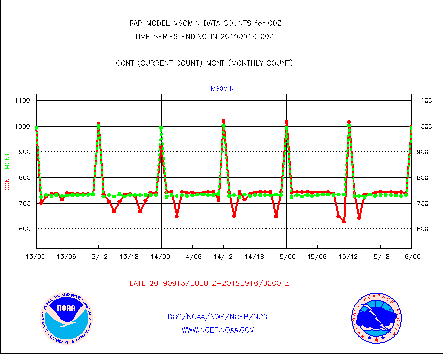
msomin |
Mesonet/MADIS Minnesota Dept. of Transportation |
1000 |
995 |
100.5 % |
1523.50-1600.50 |
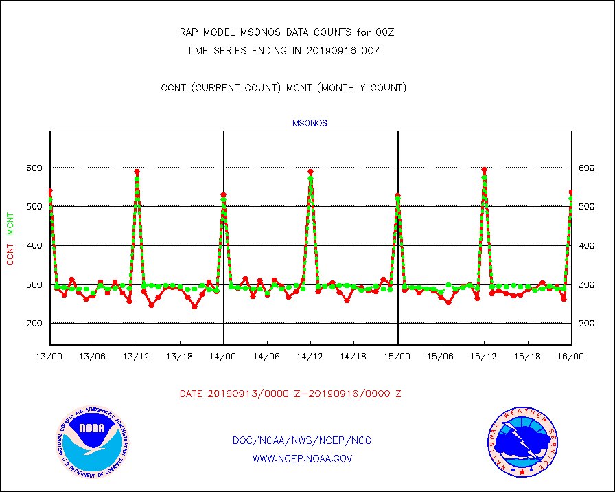
msonos |
Mesonet/MADIS NOS-Phys Oceanographic Realtime Sys |
538 |
521 |
103.3 % |
1523.50-1600.50 |
msoraw |
Mesonet/MADIS NFIC Remote Automated Wx Stns(RAWS) |
2406 |
2379 |
101.1 % |
1523.50-1600.50 |
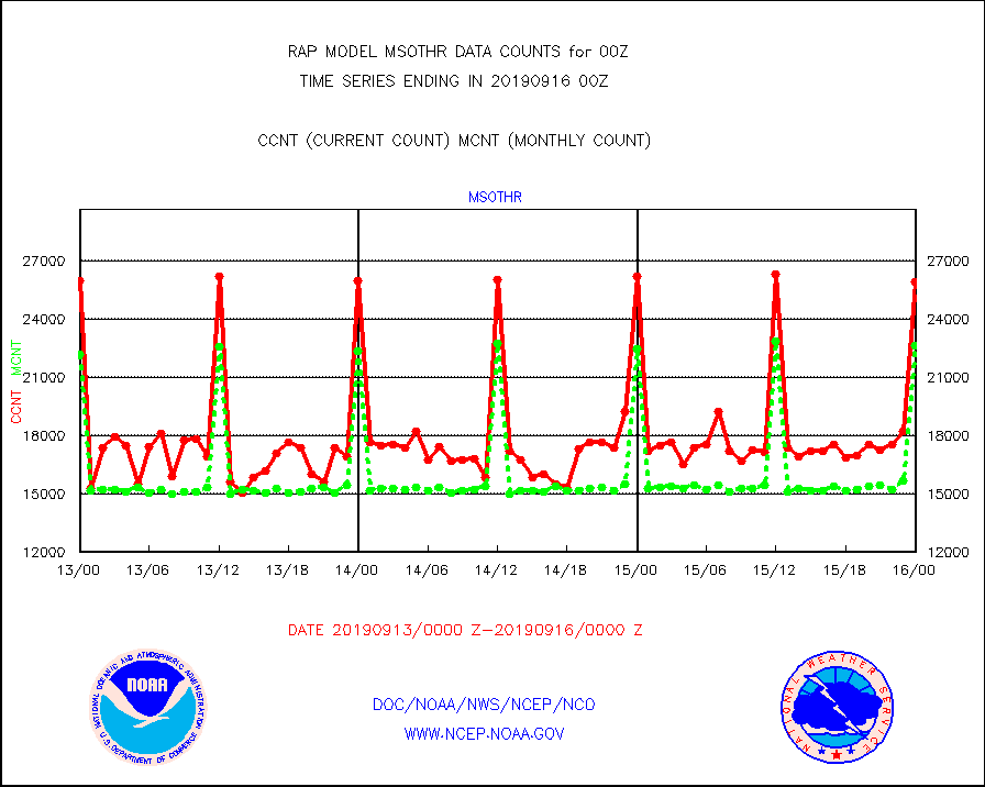
msothr |
Mesonet/MADIS many providers, not separated out |
25915 |
22646 |
114.4 % |
1523.50-1600.50 |
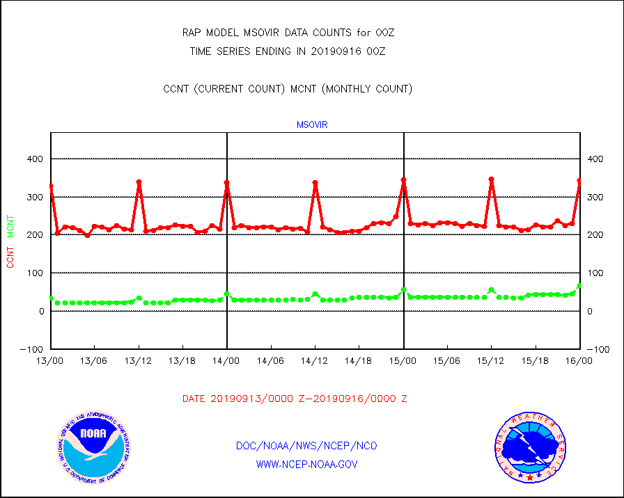
msovir |
Mesonet/MADIS Virginia Dept. of Transportation |
343 |
67 |
511.9 % |
1523.50-1600.50 |
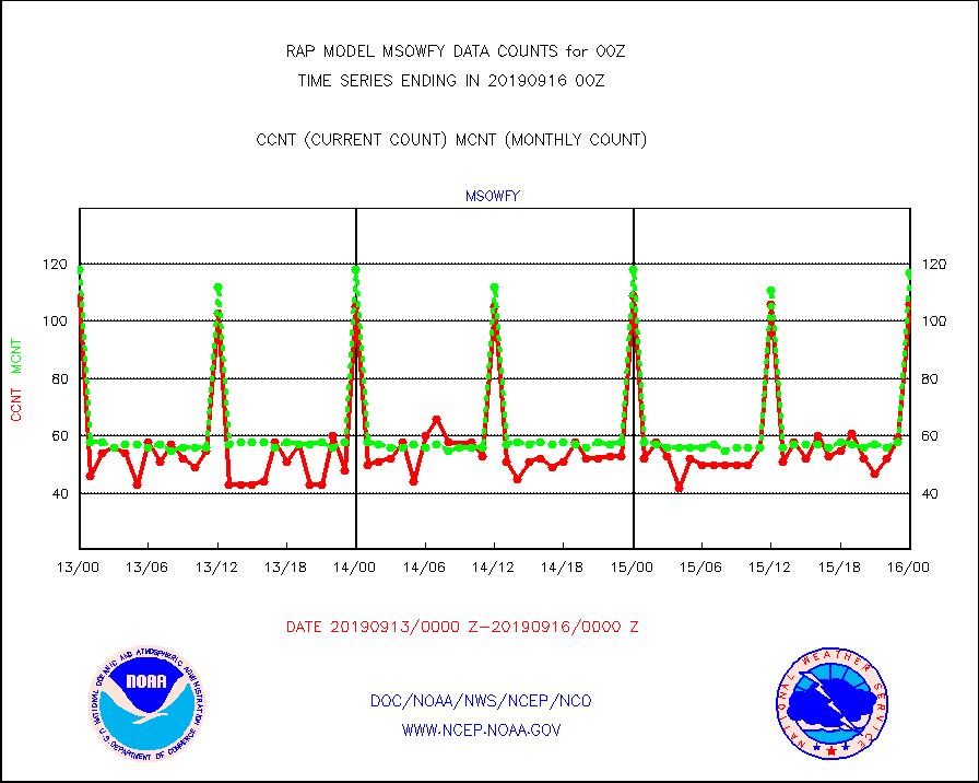
msowfy |
Mesonet/MADIS "Weather for You" |
106 |
117 |
90.6 % |
1523.50-1600.50 |
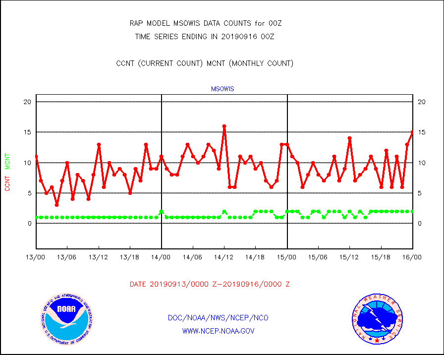
msowis |
Mesonet/MADIS Wisconsin Dept. of Transportation |
15 |
2 |
750.0 % |
1523.50-1600.50 |
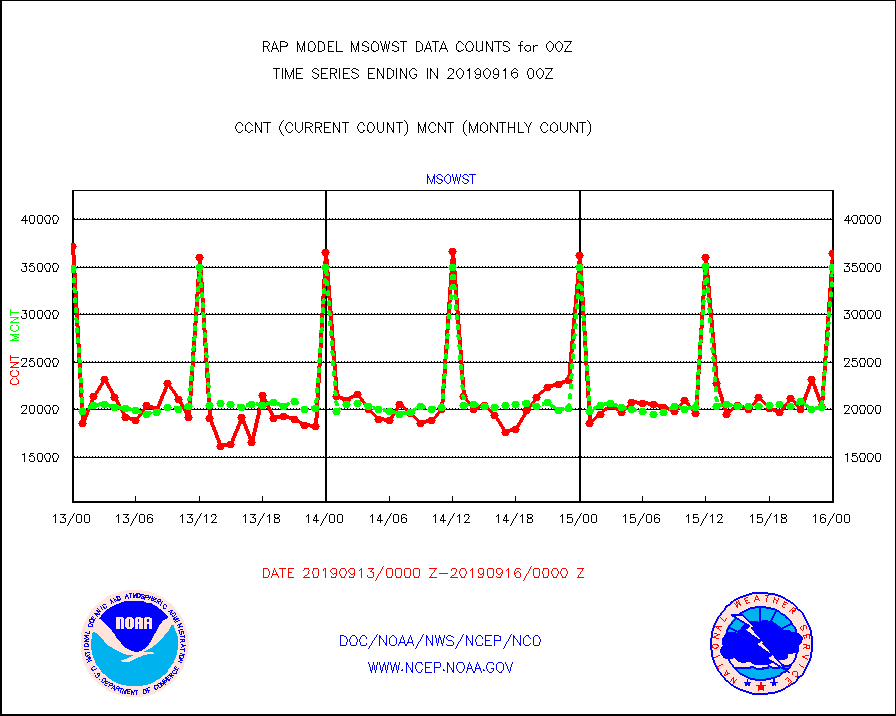
msowst |
Mesonet/MADIS MesoWest (many subproviders) |
36463 |
35020 |
104.1 % |
1523.50-1600.50 |
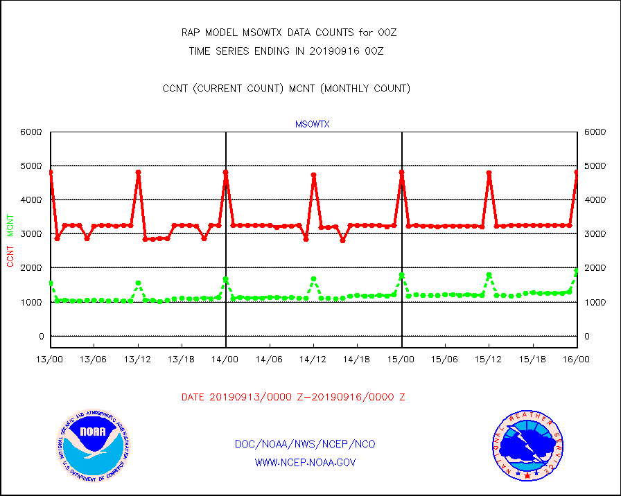
msowtx |
Mesonet/MADIS West Texas |
4815 |
1923 |
250.4 % |
1523.50-1600.50 |
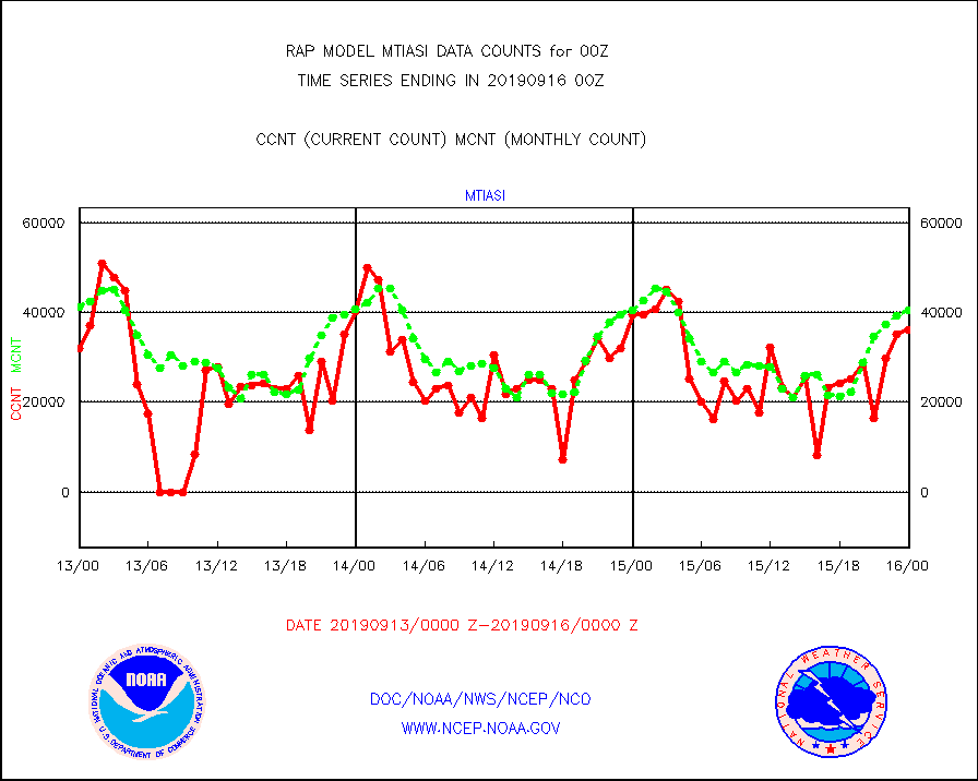
mtiasi |
METOP 1-2 IASI 1C radiance data (varbl. channels) |
36190 |
40421 |
89.5 % |
1522.00-1601.99 |
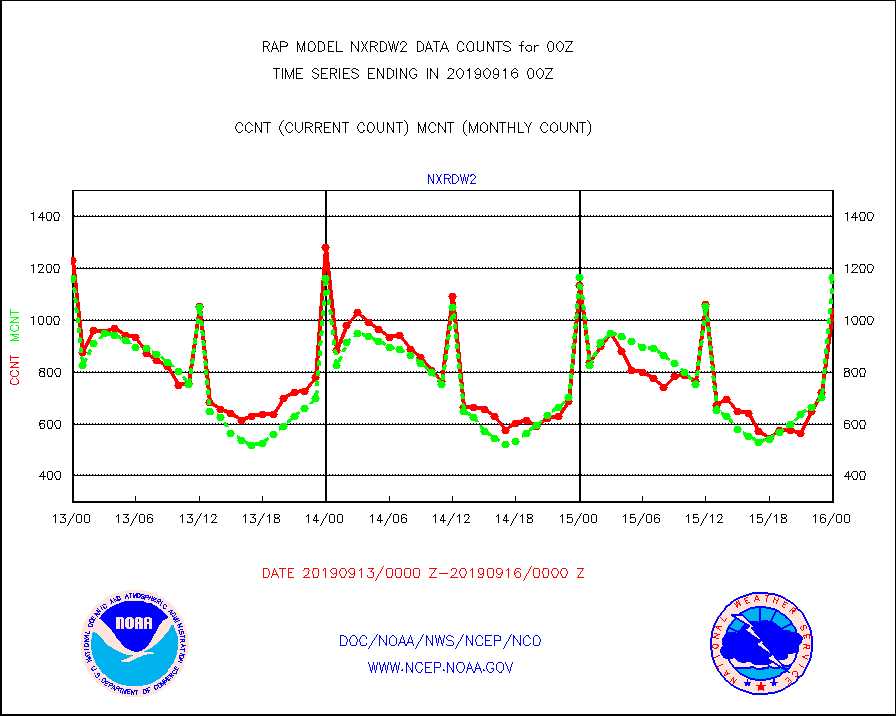
nxrdw2 |
NEXRAD Vel Azm Dsp(VAD) winds via Level 2 decoder |
1034 |
1166 |
88.7 % |
1523.00-1601.00 |
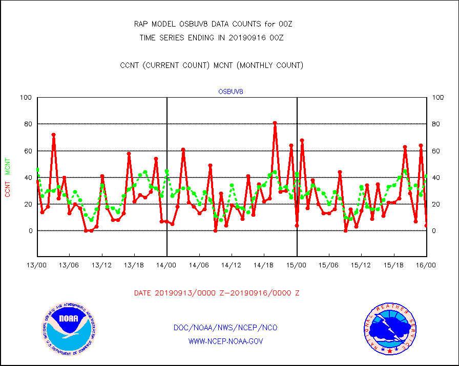
osbuv8 |
NOAA 16-19 Solar Backscatter UV-2 rad frm V8 BUFR |
4 |
41 |
9.8 % |
1522.00-1600.99 |
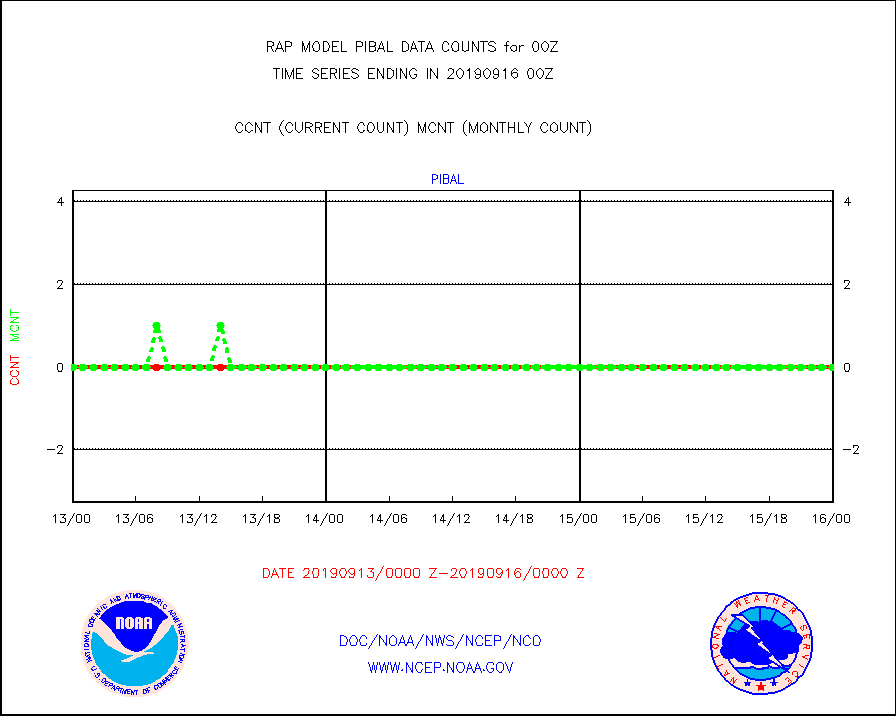
pibal |
PIBAL (from PILOT, PILOT SHIP, PILOT MOBIL) |
0 |
0 |
n/a |
1523.00-1601.00 |
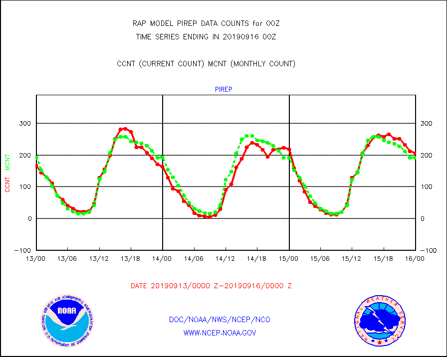
pirep |
Manual PIREP aircraft data (dcded from AIREP fmt) |
206 |
192 |
107.3 % |
1520.75-1603.25 |
prflrp |
Profilr winds from PIBAL (PILOT,PILOT SHIP/MOBIL) |
0 |
0 |
n/a |
1522.50-1601.50 |
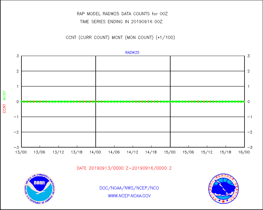
radw25 |
NEXRAD radial wind superobs (Level 2.5 - ORPG) |
0 |
0 |
n/a |
1523.00-1601.00 |
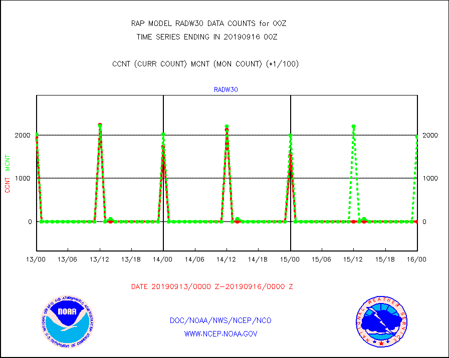
radw30 |
NEXRAD radial wind superobs (Level 3 - NIDS) |
0 |
197218 |
0.0 % |
1523.00-1601.00 |
raobm |
Rawinsonde - mobile land (from TEMP/PILOT MOBIL) |
0 |
0 |
n/a |
1523.00-1601.00 |
raobs |
Rawinsonde - ship (from TEMP SHIP, PILOT SHIP) |
2 |
0 |
n/a |
1523.00-1601.00 |
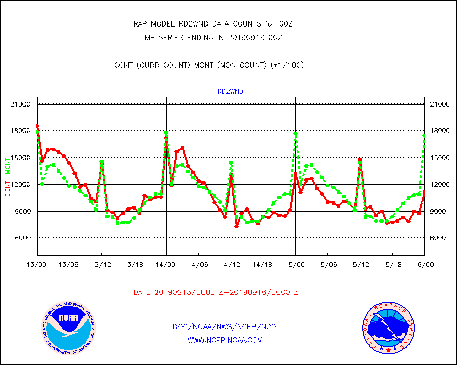
rd2wnd |
NEXRAD radial wind (Level 2 - GTS) |
1114336 |
1751283 |
63.6 % |
1523.50-1600.49 |
recco |
Flight level reconnaissance aircraft data |
0 |
2 |
0.0 % |
1523.00-1601.00 |
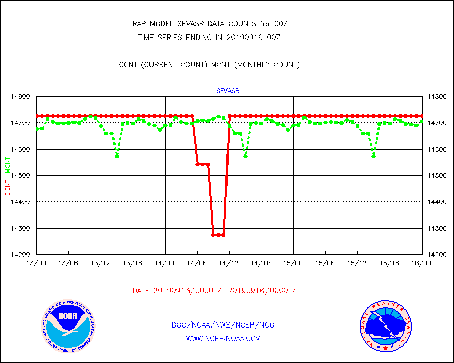
sevasr |
METEOSAT-10 2nd Gen SEVIRI All Sky Radiance(proc) |
14727 |
14707 |
100.1 % |
1522.00-1601.99 |
sevcsr |
METEOSAT-10 2nd Gen SEVIRI Clr Sky Radiance(proc) |
14727 |
14727 |
100.0 % |
1522.00-1601.99 |
ssmisu |
DMSP SSM/IS 1C radiance data (Unified Pre-Proc.) |
117010 |
88666 |
132.0 % |
1522.00-1601.99 |
synopr |
Synoptic - restricted (WMO Res 40) manual & auto. |
13 |
13 |
100.0 % |
1523.50-1600.50 |
tmdara |
TAMDAR aircft data-all types(from Panasonic,BUFR) |
6967 |
6456 |
107.9 % |
1520.75-1603.25 |
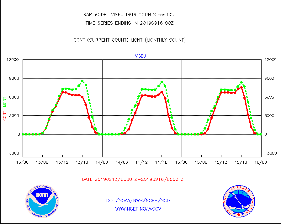
viseu |
METEOSAT/EUMETSAT visible derived cloud motion |
0 |
0 |
n/a |
1522.50-1601.49 |
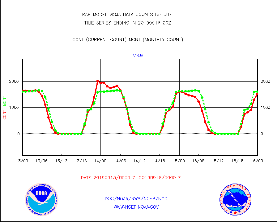
visja |
MTSAT/JMA visible derived cloud motion |
1526 |
1614 |
94.5 % |
1522.50-1601.50 |
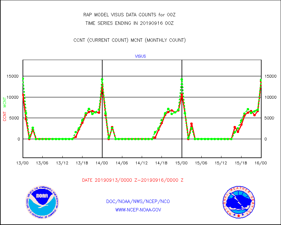
visus |
GOES/NESDIS visible derived cloud motion |
13767 |
14141 |
97.4 % |
1523.00-1523.99 |


