| Critical Data with Normal Counts |
|---|
| Type | Description | Hourly Count | Monthly Average | Percent (%) of Monthly Mean | UTC Time Window |
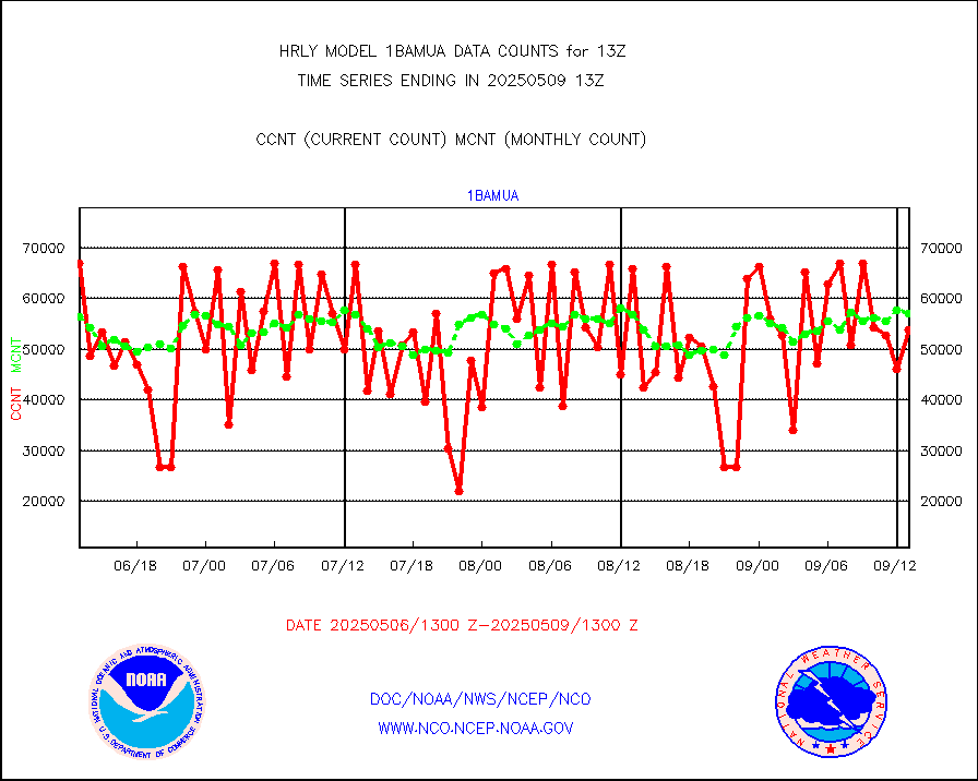
1bamua |
NOAA 15-19 & METOP 1-2 AMSU-A NCEP-proc. br.temps |
58748 |
57033 |
103.0 % |
1911.00-1911.99 |
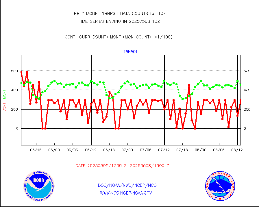
1bhrs4 |
NOAA 18-19 & METOP 1-2 HIRS-4 NCEP-proc. br.temps |
44762 |
50665 |
88.3 % |
1911.00-1911.99 |
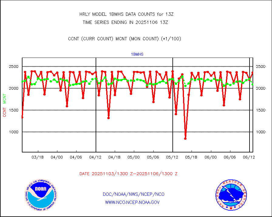
1bmhs |
NOAA 18-19 & METOP 1-2 MHS NCEP-proces. br. temps |
352655 |
321357 |
109.7 % |
1911.00-1911.99 |
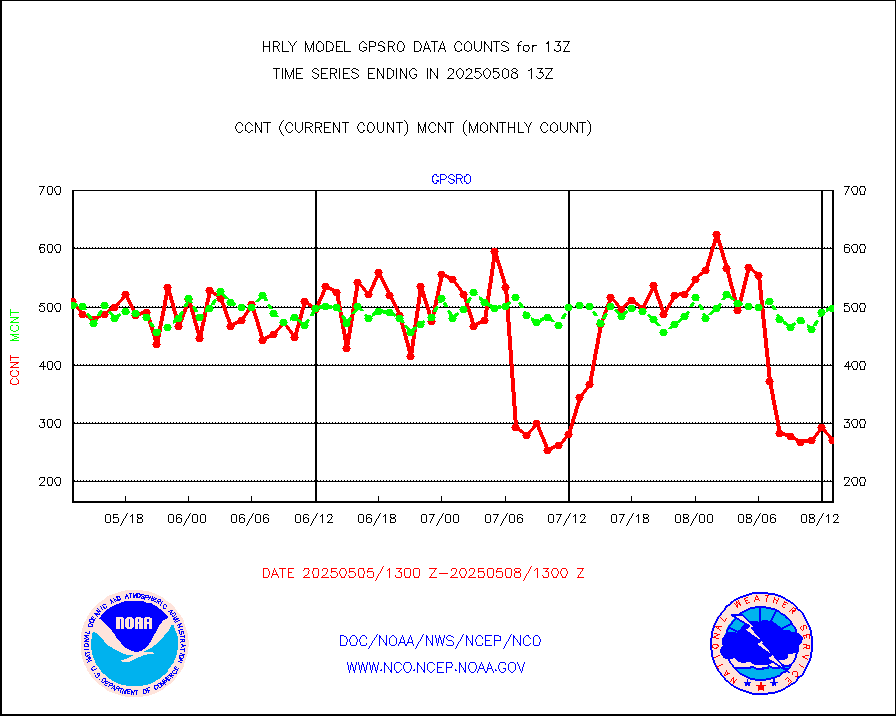
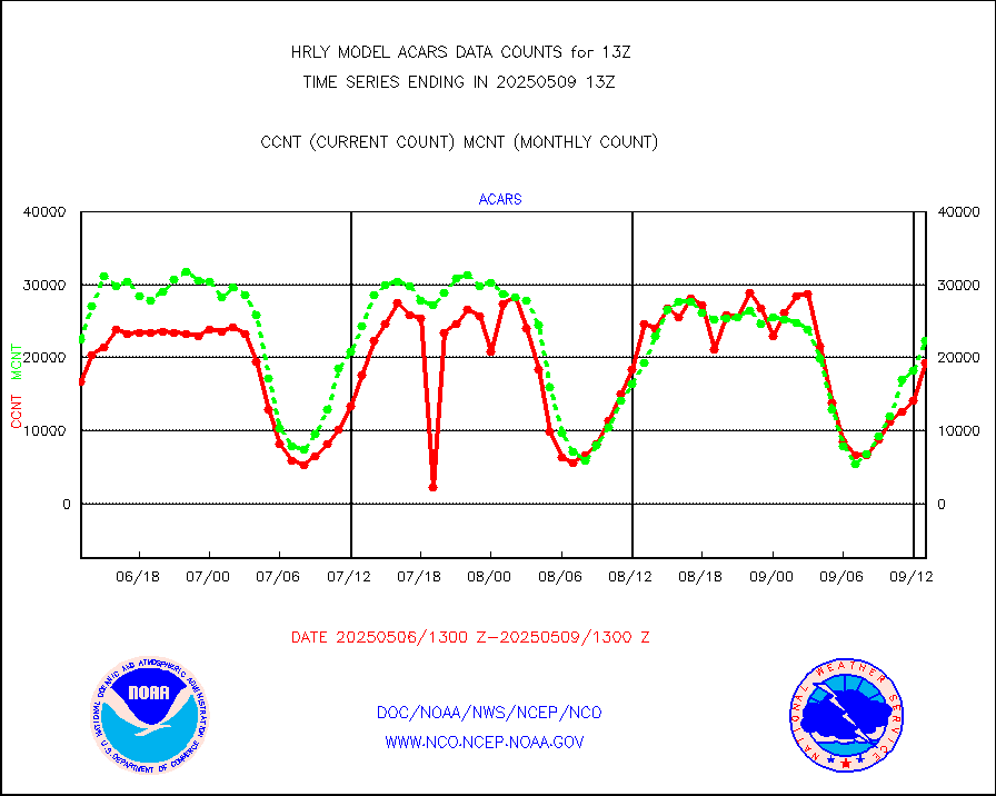
acars |
MDCRS ACARS acft data from ARINC(dcded from BUFR) |
16084 |
14021 |
114.7 % |
1912.50-1913.49 |
airep |
Manual AIREP aircraft data (dcded from AIREP fmt) |
1599 |
1527 |
104.7 % |
1912.50-1913.49 |
airsev |
AQUA AIRS/AMSU-A/HSB brightness temps- every FOV |
0 |
0 |
n/a |
1910.50-1911.49 |
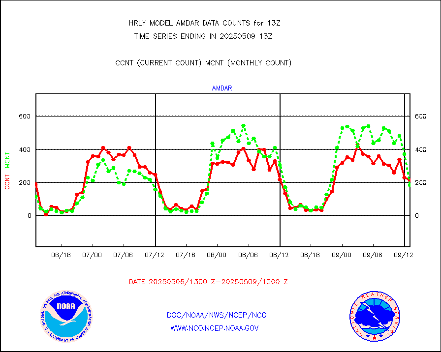
amdar |
AMDAR aircraft data (decoded from AMDAR format) |
157 |
126 |
124.6 % |
1912.50-1913.49 |
amdarb |
AMDAR aircraft data (decoded from BUFR) |
706 |
609 |
115.9 % |
1912.50-1913.49 |
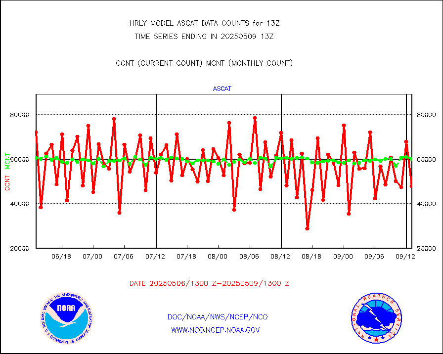
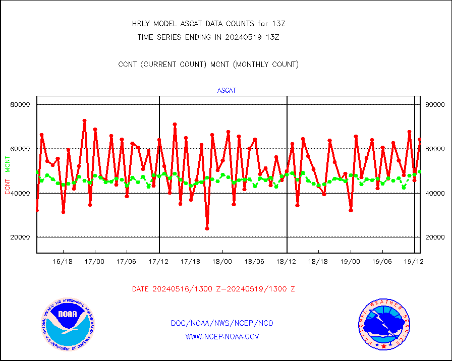
ascat |
METOP 1-2 ASCAT products |
64218 |
49602 |
129.5 % |
1911.50-1912.49 |
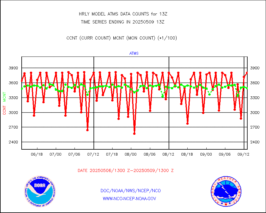
atms |
NPP/NOAA-20 ATMS brightness temperatures |
362112 |
349568 |
103.6 % |
1911.50-1912.49 |
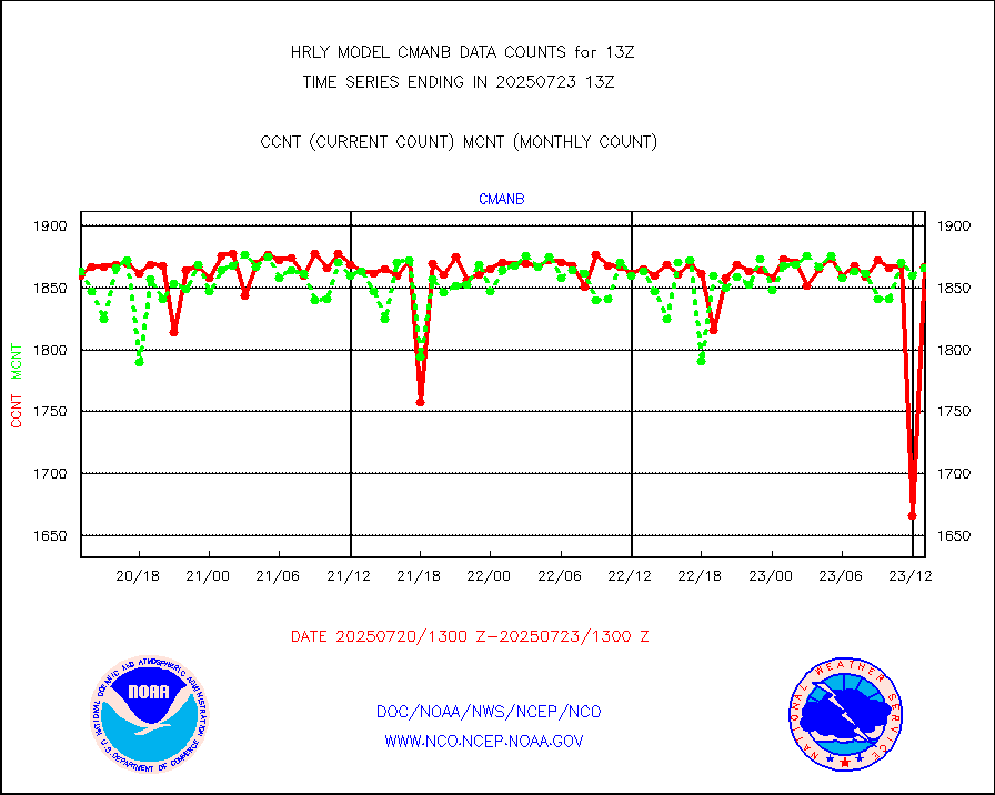
cmanb |
Surface Marine CMAN rpts decoded from BUFR format |
1783 |
1804 |
98.8 % |
1912.50-1913.50 |
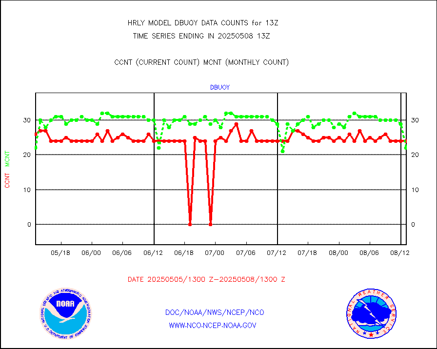
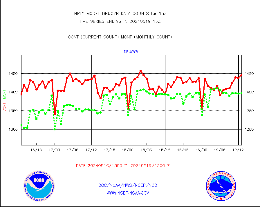
dbuoy |
Buoys decoded from FM-18 fmt (moored or drifting) |
0 |
21 |
0.0 % |
1912.50-1913.49 |
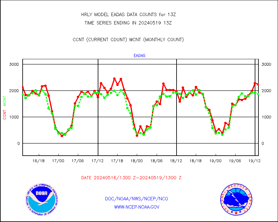
eadas |
E-AMDAR (European AMDAR acft decoded from BUFR) |
2231 |
1872 |
119.2 % |
1912.50-1913.49 |
esamua |
NOAA 15-19 & METOP 1-2 AMSU-A proc btmps frm RARS |
41531 |
39867 |
104.2 % |
1912.50-1913.49 |
eshrs3 |
NOAA 15-19 & METOP 1-2 HIRS-3/4 pr btmps frm RARS |
86728 |
81916 |
105.9 % |
1912.50-1913.49 |
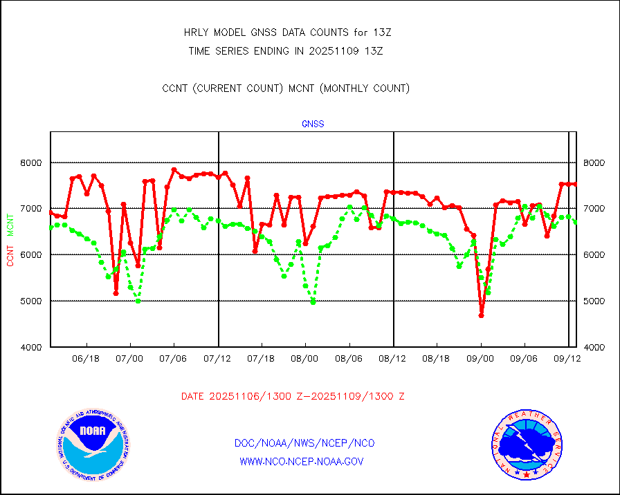
gnss |
Grnd-based Gbl Navigation Sat System (GNSS) data |
8701 |
9182 |
94.8 % |
1912.00-1912.99 |
gpsro |
GPS radio occultation data |
469 |
444 |
105.6 % |
1910.50-1911.49 |
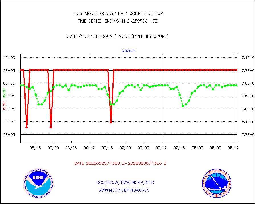
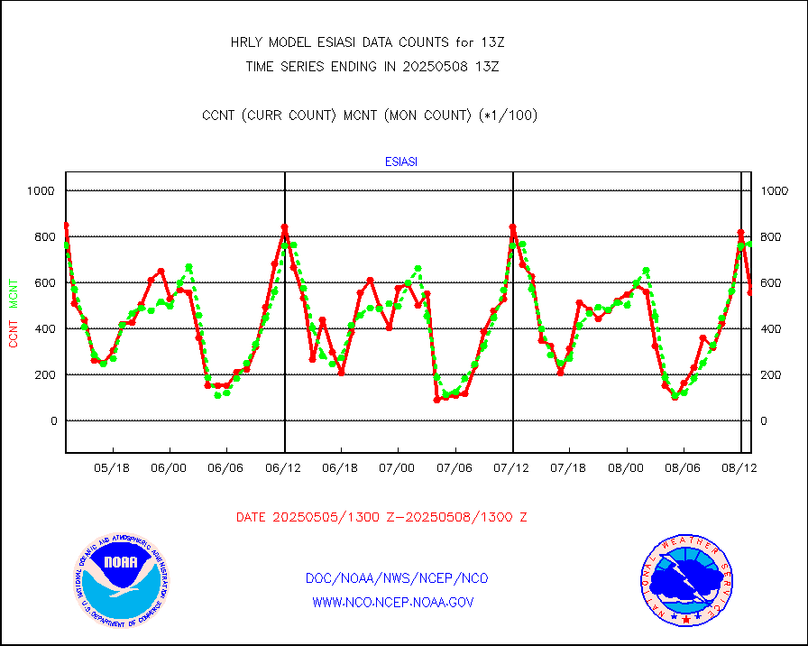
gsrasr |
GOES-16/17 All Sky Radiances (proc.) |
720952 |
699925 |
103.0 % |
1912.50-1913.49 |
gsrcsr |
GOES-16/17 Clear Sky Radiances (proc.) |
325326 |
331796 |
98.1 % |
1912.50-1913.49 |
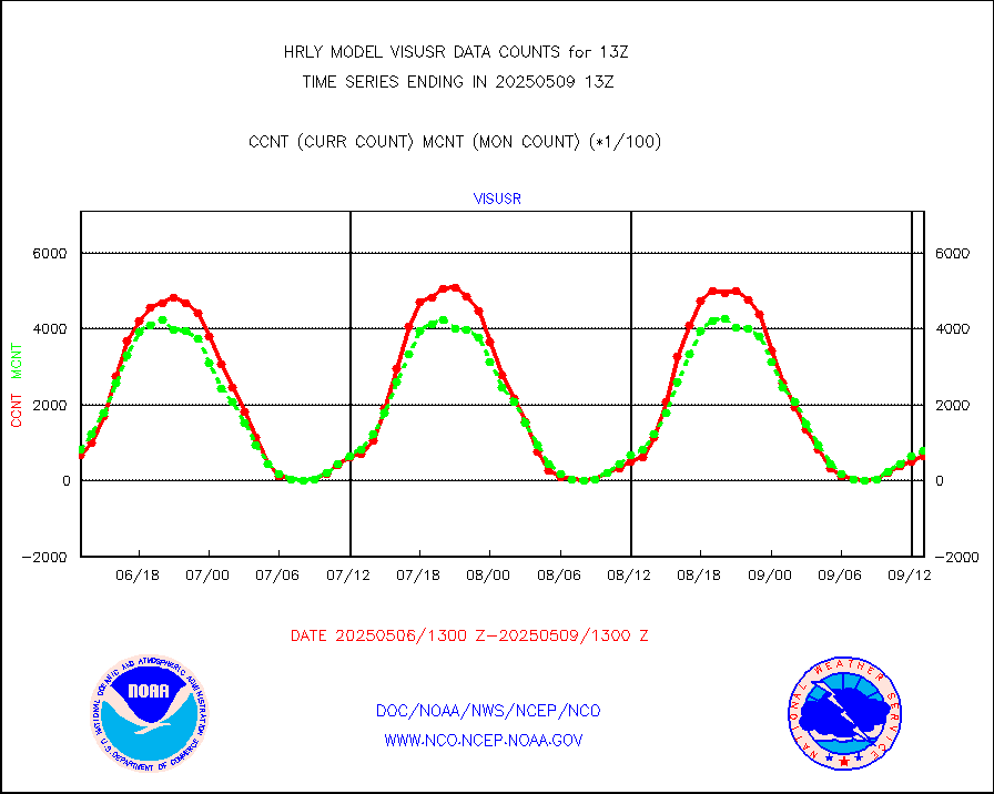
h20ja |
MTSAT/JMA water vapor imager derived cloud motion |
20359 |
18819 |
108.2 % |
1910.50-1911.49 |
h20mo |
MODIS (AQUA/TERRA) wvpr imager derived cld motion |
0 |
0 |
n/a |
1909.00-1909.99 |
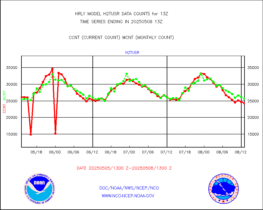
h2tusr |
GOES-16&up/NESDIS wv imgr/cld-top derived cld mtn |
22932 |
24711 |
92.8 % |
1912.00-1912.99 |
ifeunb |
METEOSAT/EUMETSAT ir lg-wave drv cld motion NBseq |
22262 |
21931 |
101.5 % |
1911.50-1912.49 |
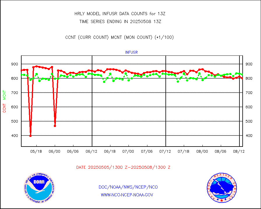
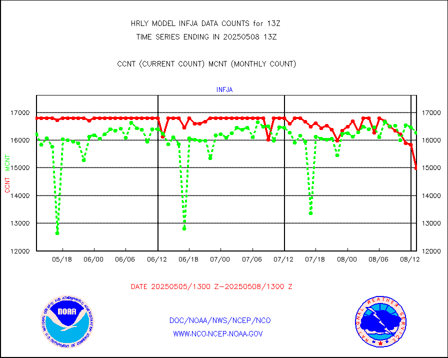
infja |
MTSAT/JMA infrared long-wave derived cloud motion |
16778 |
15801 |
106.2 % |
1910.50-1911.49 |
infmo |
MODIS (AQUA/TERRA) ir l-wave derived cloud motion |
0 |
0 |
n/a |
1909.00-1909.99 |
infusr |
GOES-16&up/NESDIS ir long-wave derived cld motion |
79194 |
80431 |
98.5 % |
1912.00-1912.99 |
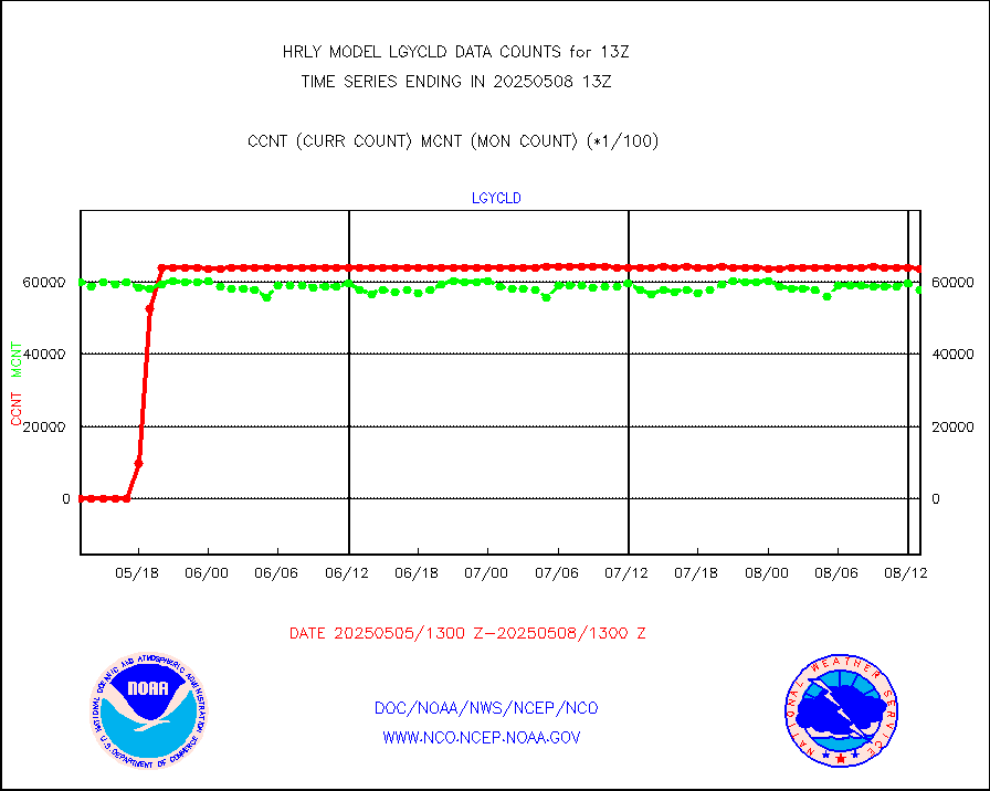
lgycld |
GOES/NASA(Langley) hi-res. (1x1 f-o-v) cloud data |
4192507 |
3456012 |
121.3 % |
1912.50-1913.49 |
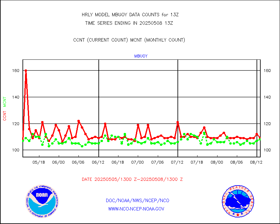
mbuoy |
Buoys decoded from FM-13 format (moored) |
117 |
117 |
100.0 % |
1912.50-1913.49 |
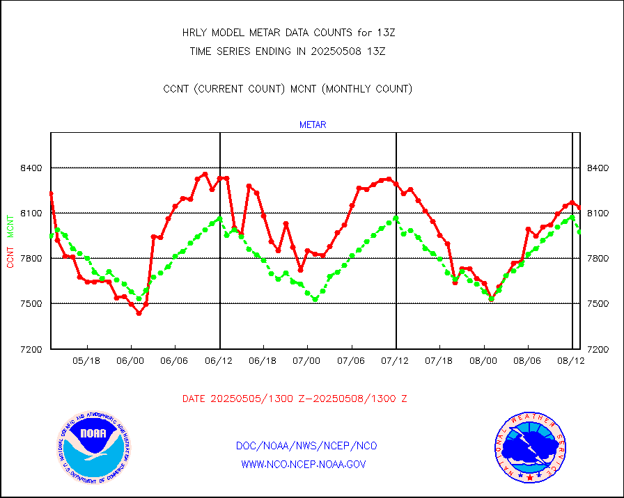
metar |
Aviation - METAR |
7775 |
8087 |
96.1 % |
1912.50-1913.49 |
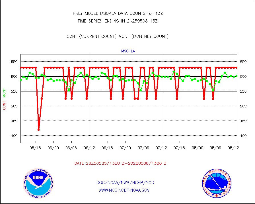
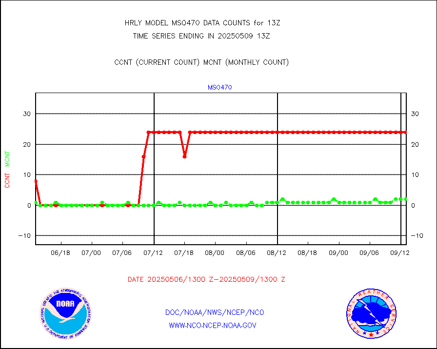
mso470 |
Mesonet/MADIS Colorado E-470 (Interstate 470) |
21 |
20 |
105.0 % |
1912.50-1913.49 |
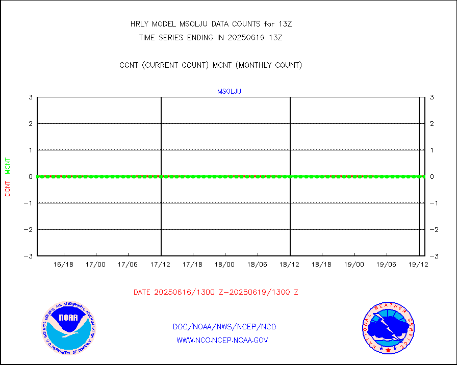
msoalk |
Mesonet/MADIS Alaska Department of Transportation |
109 |
107 |
101.9 % |
1912.50-1913.49 |
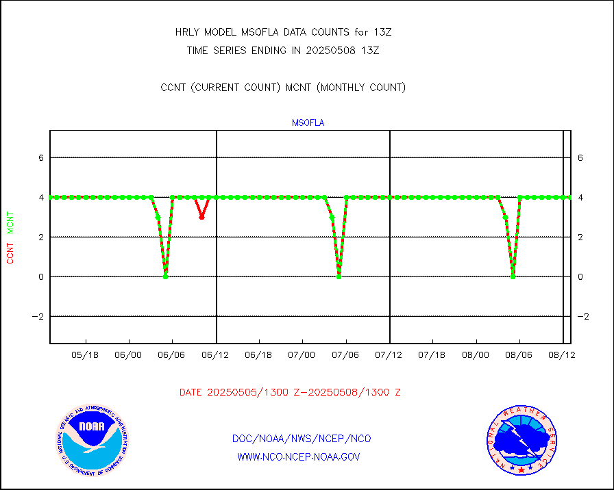
msoapg |
Mesonet/MADIS U.S. Army Aberdeen Proving Grounds |
0 |
0 |
n/a |
1912.50-1913.49 |
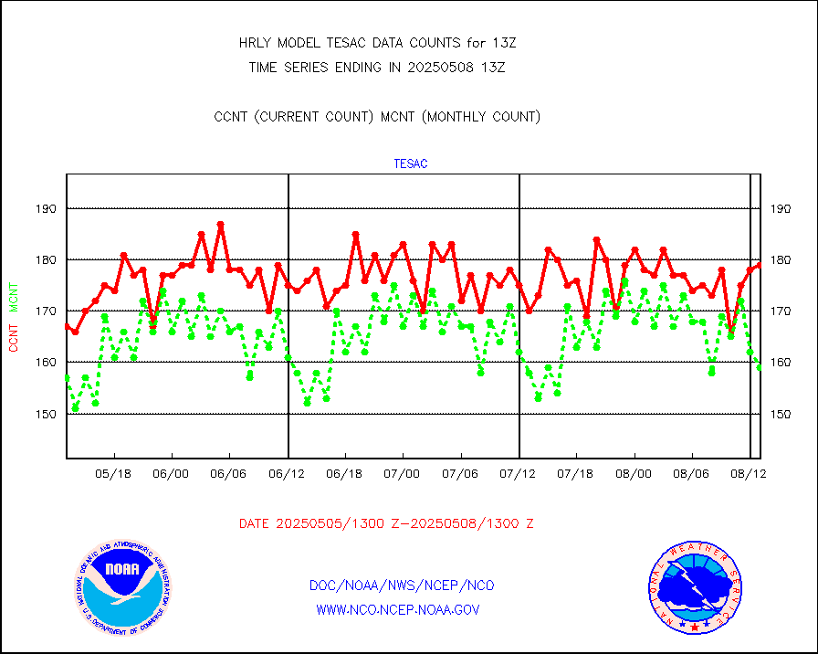
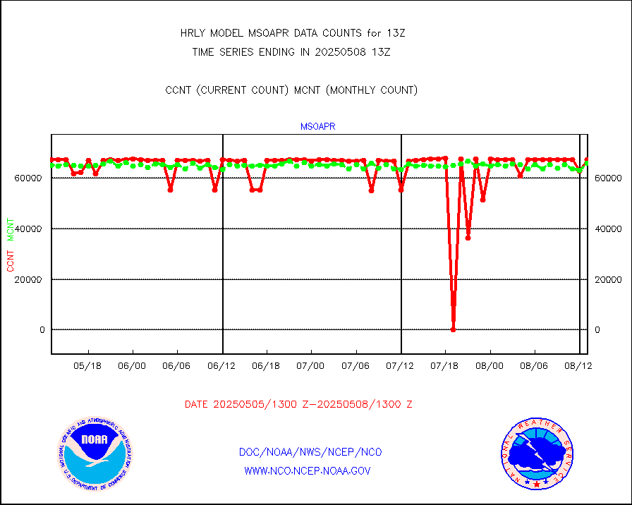
msoapr |
Mesonet/MADIS Citizen Weather Observers Program |
46217 |
48720 |
94.9 % |
1912.50-1913.49 |
msoaws |
Mesonet/MADIS AWS Convergence Technologies, Inc. |
24298 |
25711 |
94.5 % |
1912.50-1913.49 |
msoawx |
Mesonet/MADIS "Anything Weather" |
0 |
0 |
n/a |
1912.50-1913.49 |
msocol |
Mesonet/MADIS Colorado Dept. of Transportation |
0 |
0 |
n/a |
1912.50-1913.49 |
msodcn |
Mesonet/MADIS DC Net |
0 |
0 |
n/a |
1912.50-1913.49 |
msoden |
Mesonet/MADIS Denver Urban Drainage & Flood Cntrl |
250 |
250 |
100.0 % |
1912.50-1913.49 |
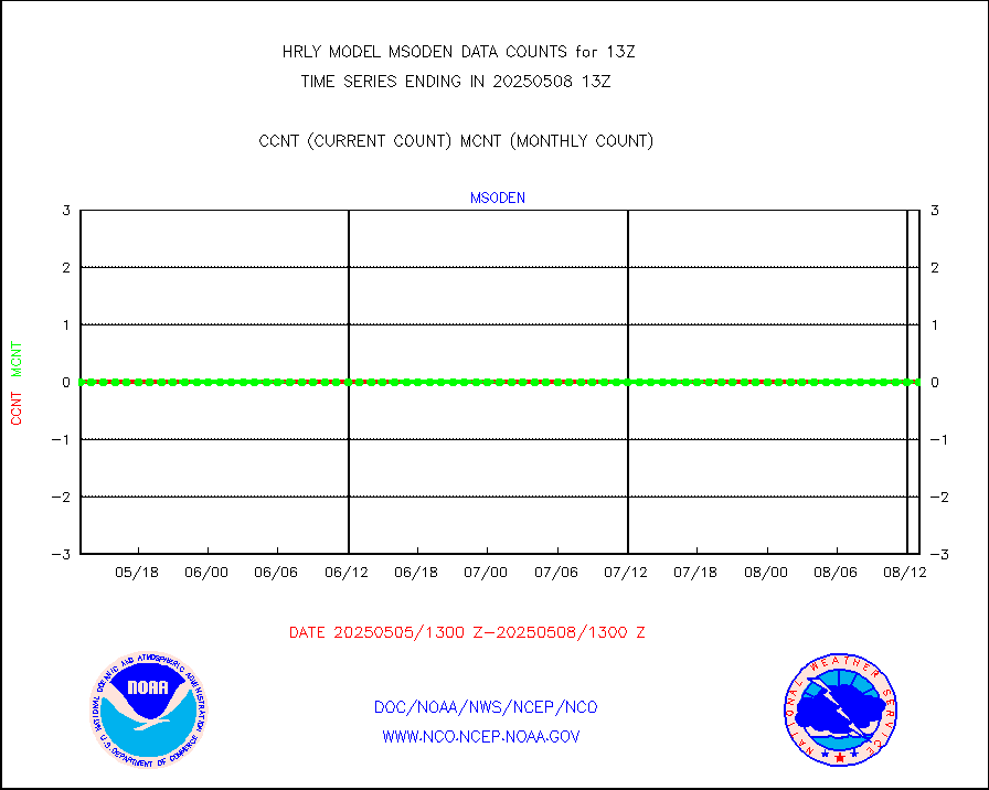
msofla |
Mesonet/MADIS Florida (FAWN & USF) |
4 |
4 |
100.0 % |
1912.50-1913.49 |
msoflt |
Mesonet/MADIS Florida Dept. of Transportation |
0 |
0 |
n/a |
1912.50-1913.49 |
msogeo |
Mesonet/MADIS Georgia Dept. of Transportation |
0 |
0 |
n/a |
1912.50-1913.49 |
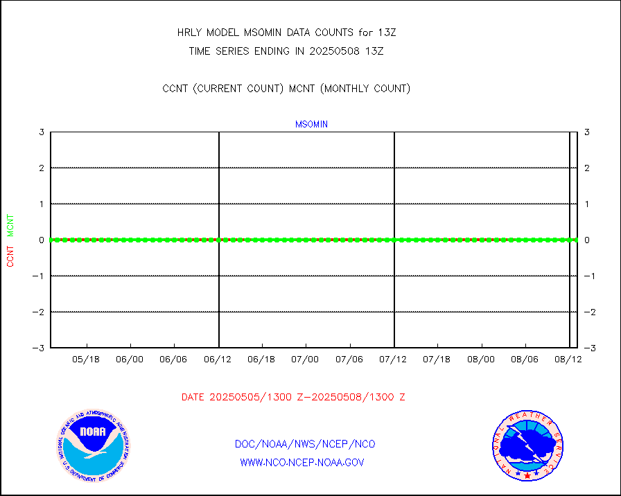
msohad |
Mesonet/MADIS NWS Hydromet Auto Data System(HADS) |
6818 |
6610 |
103.1 % |
1912.50-1913.49 |
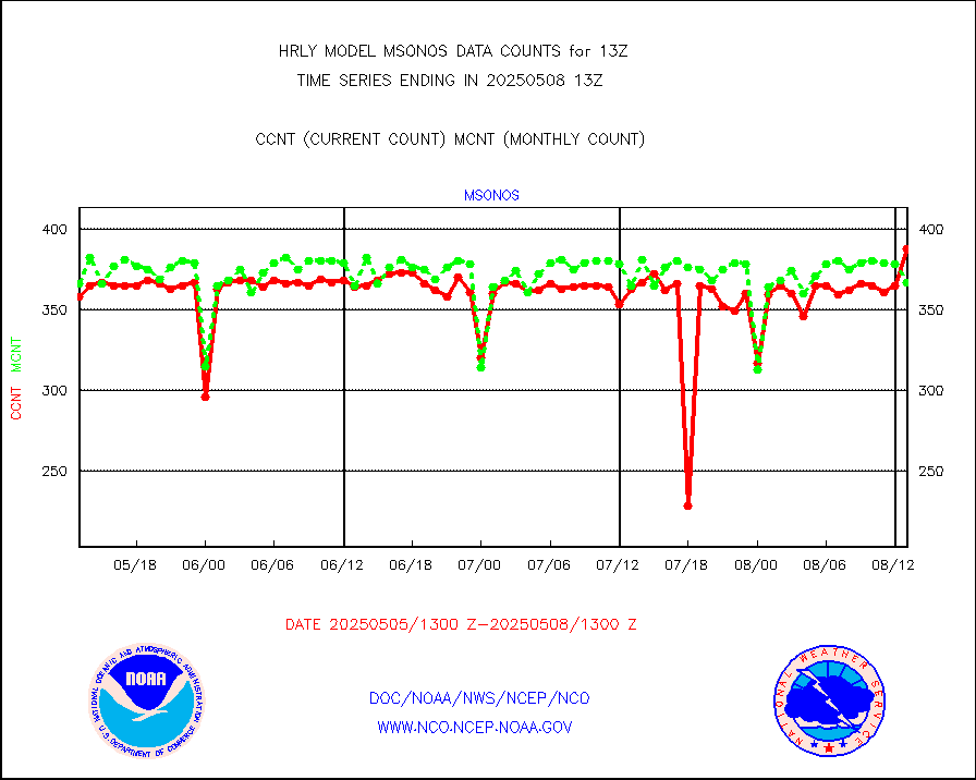
msoien |
Mesonet/MADIS Iowa Environmental |
185 |
188 |
98.4 % |
1912.50-1913.49 |
msoind |
Mesonet/MADIS Indiana Dept. of Transportation |
0 |
0 |
n/a |
1912.50-1913.49 |
msoiow |
Mesonet/MADIS Iowa Department of Transportation |
0 |
0 |
n/a |
1912.50-1913.49 |
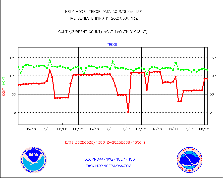
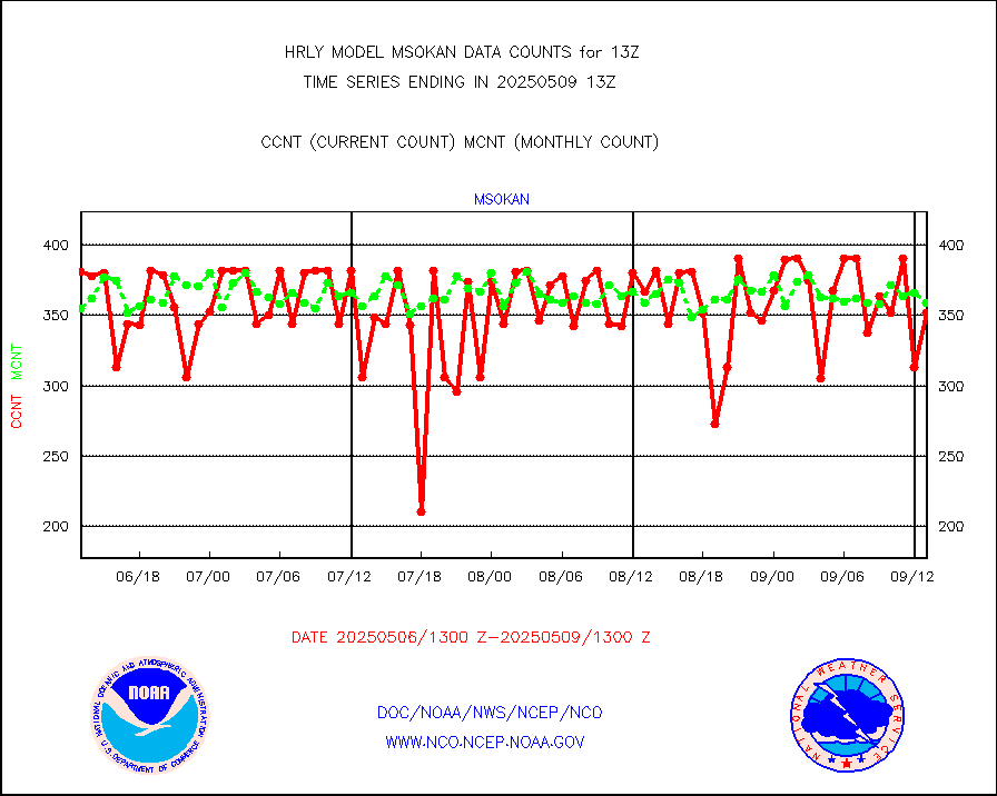
msokan |
Mesonet/MADIS Kansas Department of Transportation |
309 |
354 |
87.3 % |
1912.50-1913.49 |
msokla |
Mesonet/MADIS Oklahoma Mesonet |
318 |
314 |
101.3 % |
1912.50-1913.49 |
msolju |
Mesonet/MADIS Louisiana State/Jackson State Univ. |
0 |
0 |
n/a |
1912.50-1913.49 |
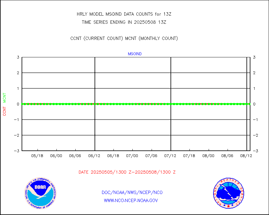
msomca |
Mesonet/MADIS Missouri Commercial Agricult Wx Net |
289 |
297 |
97.3 % |
1912.50-1913.49 |
msomin |
Mesonet/MADIS Minnesota Dept. of Transportation |
0 |
0 |
n/a |
1912.50-1913.49 |
msonos |
Mesonet/MADIS NOS-Phys Oceanographic Realtime Sys |
388 |
382 |
101.6 % |
1912.50-1913.49 |
msoraw |
Mesonet/MADIS NFIC Remote Automated Wx Stns(RAWS) |
1935 |
1789 |
108.2 % |
1912.50-1913.49 |
msovir |
Mesonet/MADIS Virginia Dept. of Transportation |
208 |
226 |
92.0 % |
1912.50-1913.49 |
msowfy |
Mesonet/MADIS "Weather for You" |
0 |
0 |
n/a |
1912.50-1913.49 |
msowis |
Mesonet/MADIS Wisconsin Dept. of Transportation |
0 |
0 |
n/a |
1912.50-1913.49 |
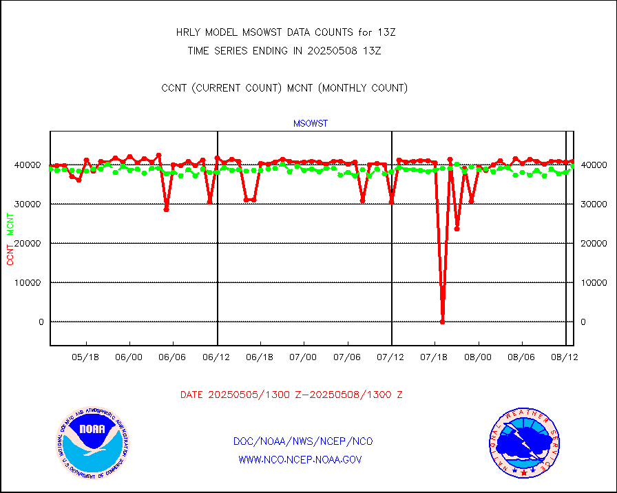
msowst |
Mesonet/MADIS MesoWest (many subproviders) |
46630 |
45559 |
102.4 % |
1912.50-1913.49 |
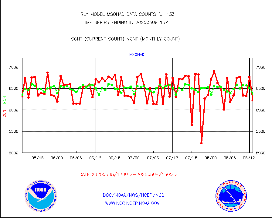
msowtx |
Mesonet/MADIS West Texas |
5592 |
5643 |
99.1 % |
1912.50-1913.49 |
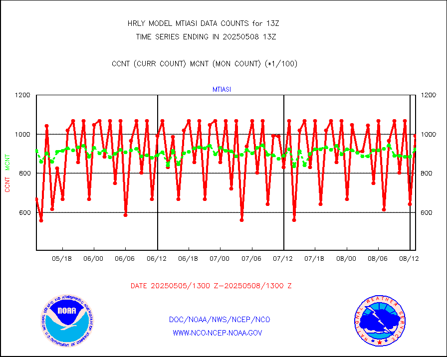
mtiasi |
METOP 1-2 IASI 1C radiance data (varbl. channels) |
106936 |
87368 |
122.4 % |
1911.00-1911.99 |
nxrdw |
NEXRAD Vel Azm Dsp(VAD) winds via radar coded msg |
0 |
0 |
n/a |
1912.50-1913.49 |
omi |
Aura Ozone Monitoring Instrument (OMI) data |
28800 |
38866 |
74.1 % |
1910.50-1911.49 |
osbuv8 |
NOAA 16-19 Solar Backscatter UV-2 rad frm V8 BUFR |
0 |
0 |
n/a |
1911.00-1911.99 |
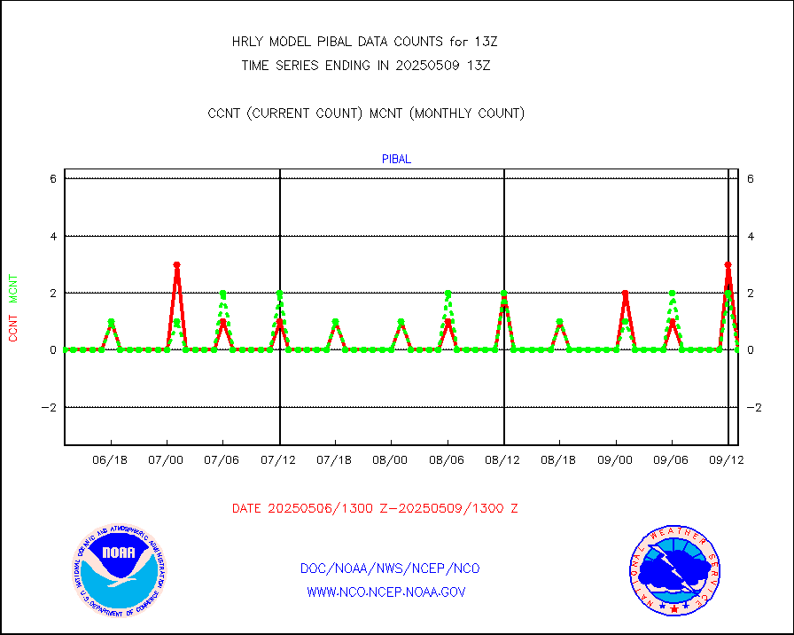
pibal |
PIBAL (from PILOT, PILOT SHIP, PILOT MOBIL) |
0 |
0 |
n/a |
1912.50-1913.49 |
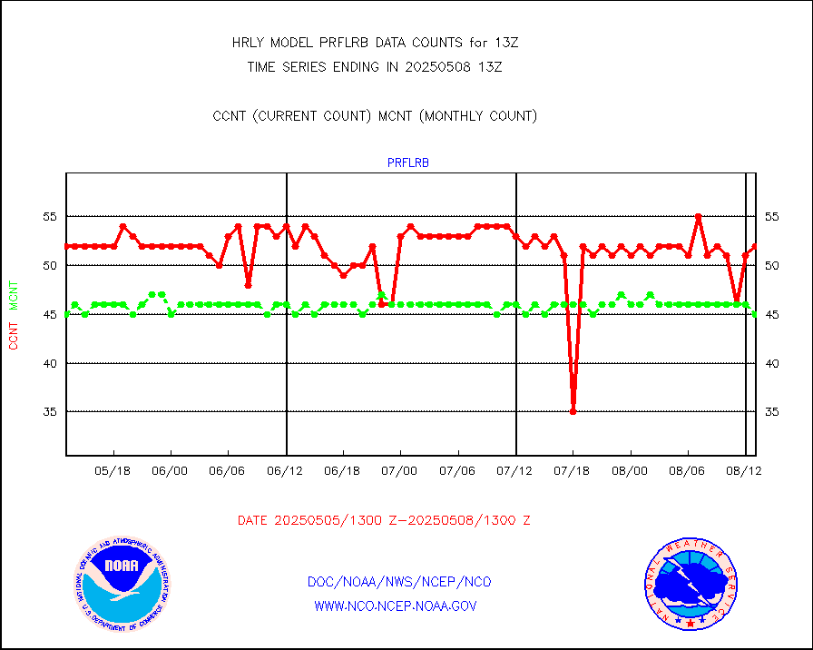
prflrb |
Multi-Agency Profiler (MAP) and SODAR winds |
35 |
41 |
85.4 % |
1912.50-1913.49 |
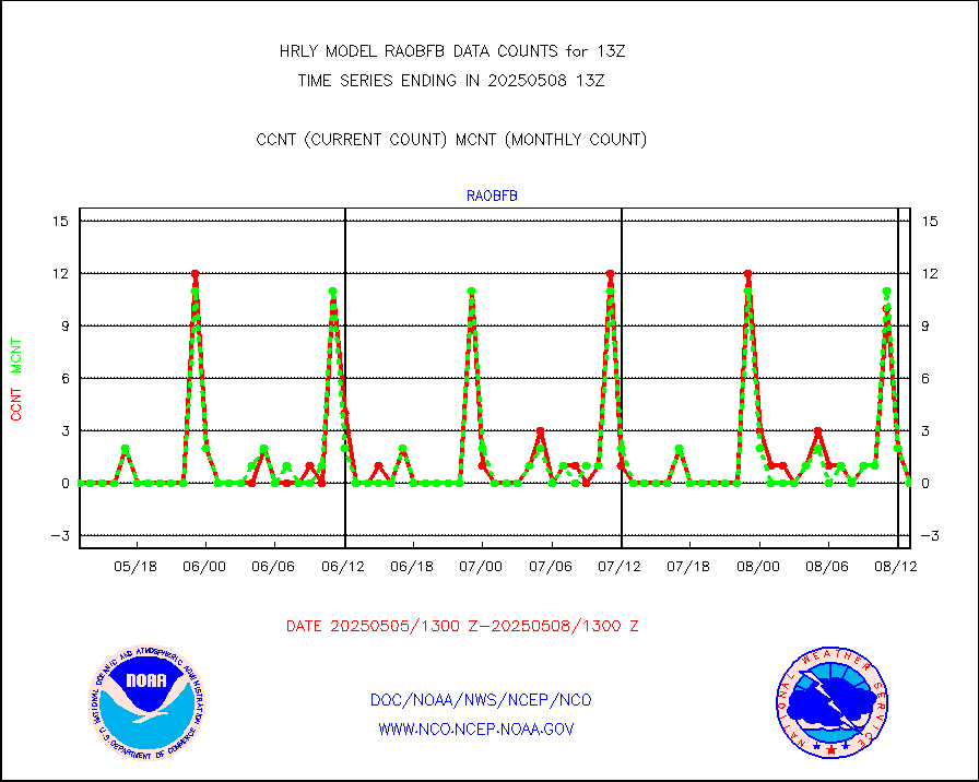
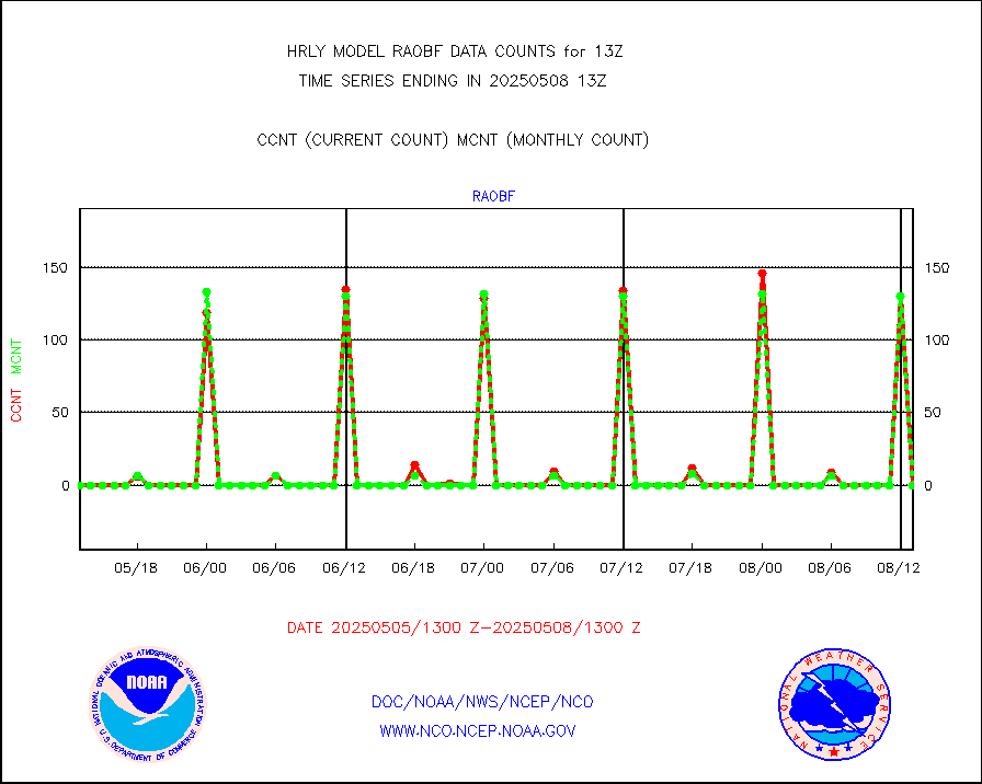
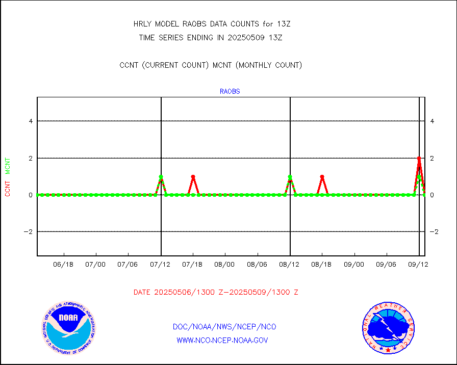
raobf |
Rawinsonde - fixed land (from TEMP or PILOT) |
0 |
0 |
n/a |
1912.50-1913.49 |
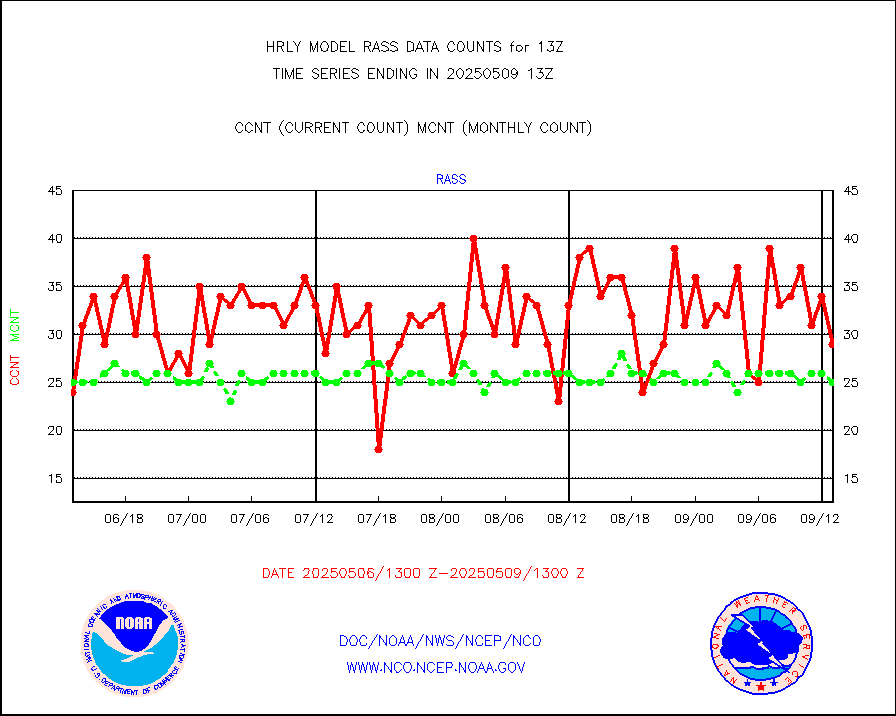
rass |
RASS temperatures (NOAA and Multi-Agency) |
19 |
27 |
70.4 % |
1912.50-1913.49 |
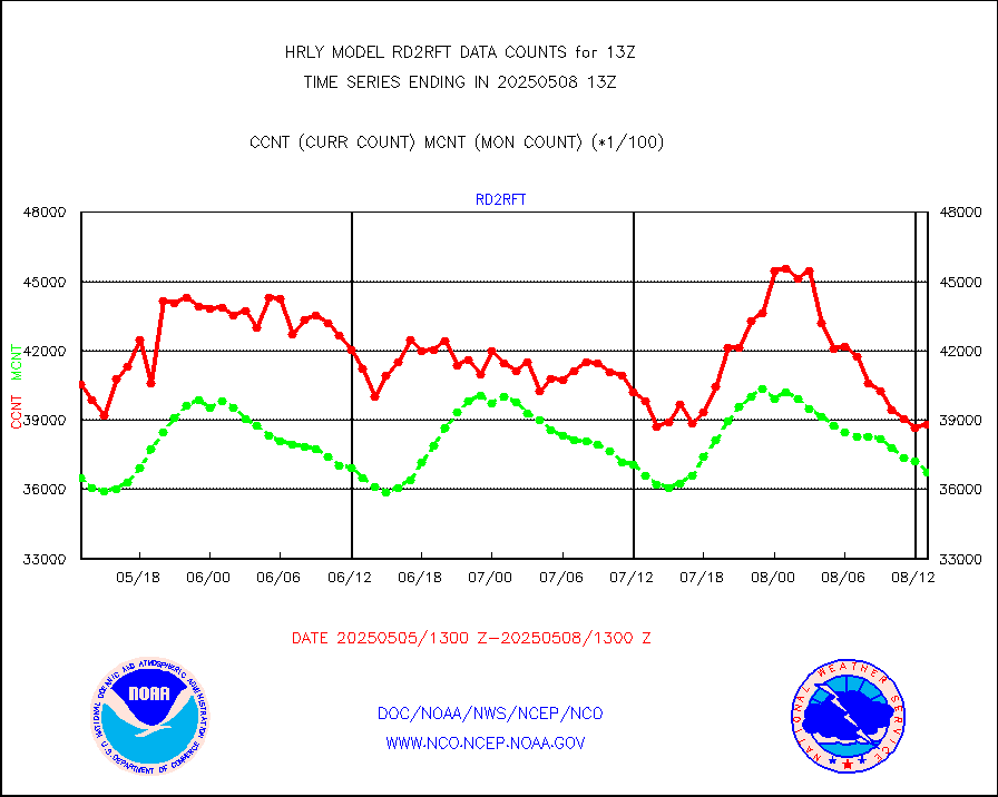
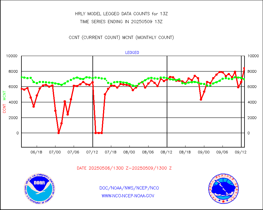
rd2rft |
NEXRAD reflectivity (Lvl 2 - GTS) |
3800550 |
3843788 |
98.9 % |
1912.50-1913.49 |
rd2wnd |
NEXRAD radial wind (Level 2 - GTS) |
1185248 |
1024116 |
115.7 % |
1912.50-1913.49 |
sevcsr |
METEOSAT-10 2nd Gen SEVIRI Clr Sky Radiance(proc) |
0 |
0 |
n/a |
1912.50-1913.49 |
shipsb |
Ship - manual and automatic, restricted (BUFR) |
1 |
0 |
n/a |
1912.50-1913.50 |
shipsu |
Ship - manual and automatic, unrestricted |
105 |
115 |
91.3 % |
1912.50-1913.50 |
shipub |
Ship - manual and automatic, unrestricted (BUFR) |
811 |
817 |
99.3 % |
1912.50-1913.50 |
synop |
Synoptic - fixed manual and automatic |
912 |
920 |
99.1 % |
1912.50-1913.49 |
synopb |
Synoptic - fixed manual & auto (decoded fr BUFR) |
4212 |
4109 |
102.5 % |
1912.50-1913.49 |
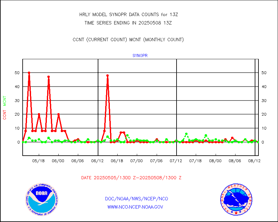
synopr |
Synoptic - restricted (WMO Res 40) manual & auto. |
0 |
1 |
0.0 % |
1912.50-1913.49 |
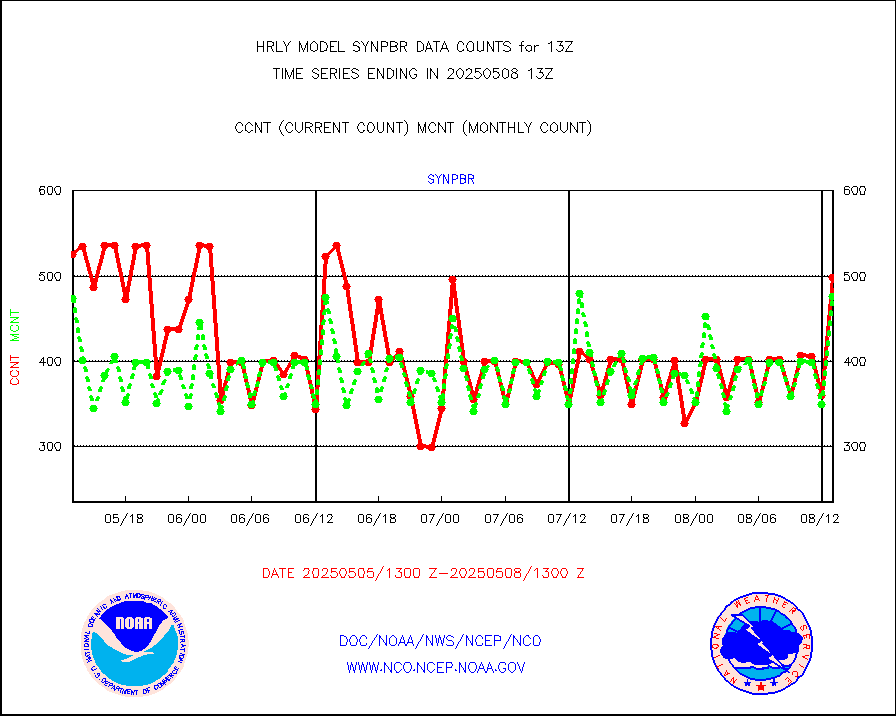
synpbr |
Synoptic - restricted (WMO Res 40)(decoded BUFR) |
399 |
463 |
86.2 % |
1912.50-1913.49 |
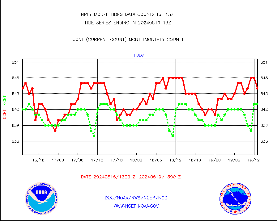
tideg |
Tide gauge reports decoded from CREX format |
646 |
643 |
100.5 % |
1912.00-1912.99 |
| Data Types of Opportunity with Normal Counts |
|---|
| Type | Description | Hourly Count | Monthly Average | Percent (%) of Monthly Mean | UTC Time Window |
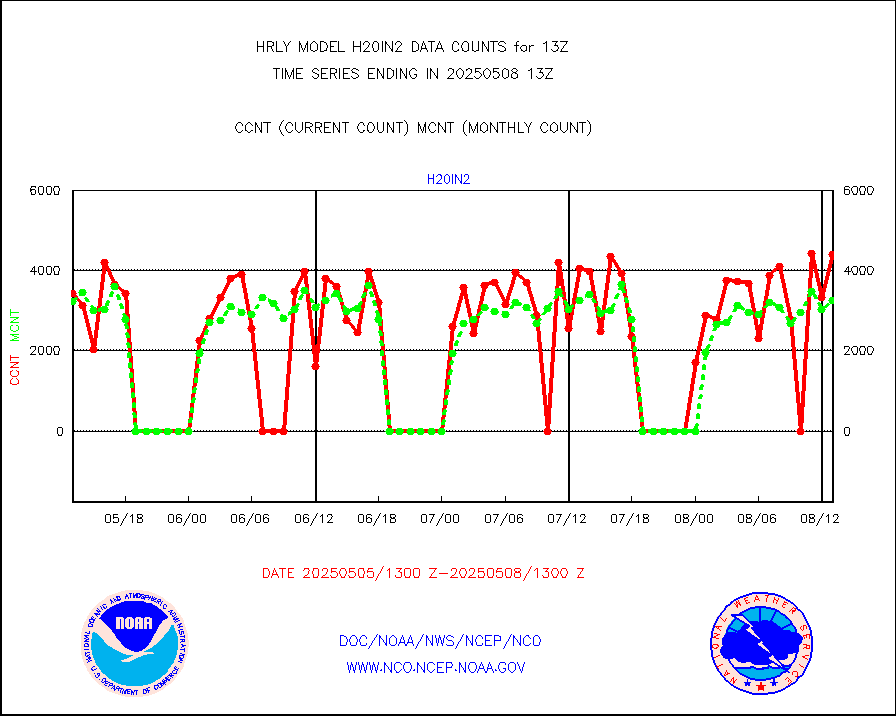
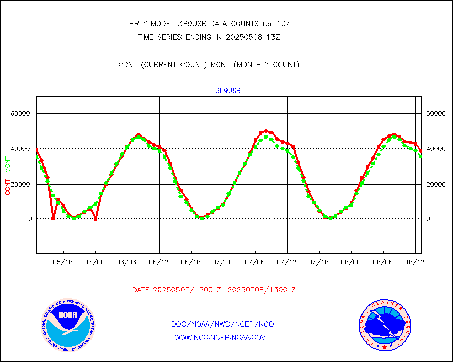
3p9usr |
GOES-16&up/NESDIS ir short-wv derived cld motion |
36949 |
36651 |
100.8 % |
1912.00-1912.99 |
acarsa |
MDCRS ACARS acft data (ARINC via AFWA)(AIREP fmt) |
0 |
0 |
n/a |
1912.50-1913.49 |
ahicsr |
Himawari Clear Sky Radiance |
0 |
0 |
n/a |
1912.00-1912.99 |
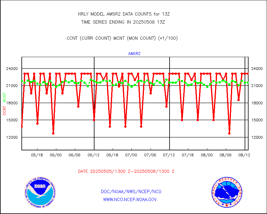
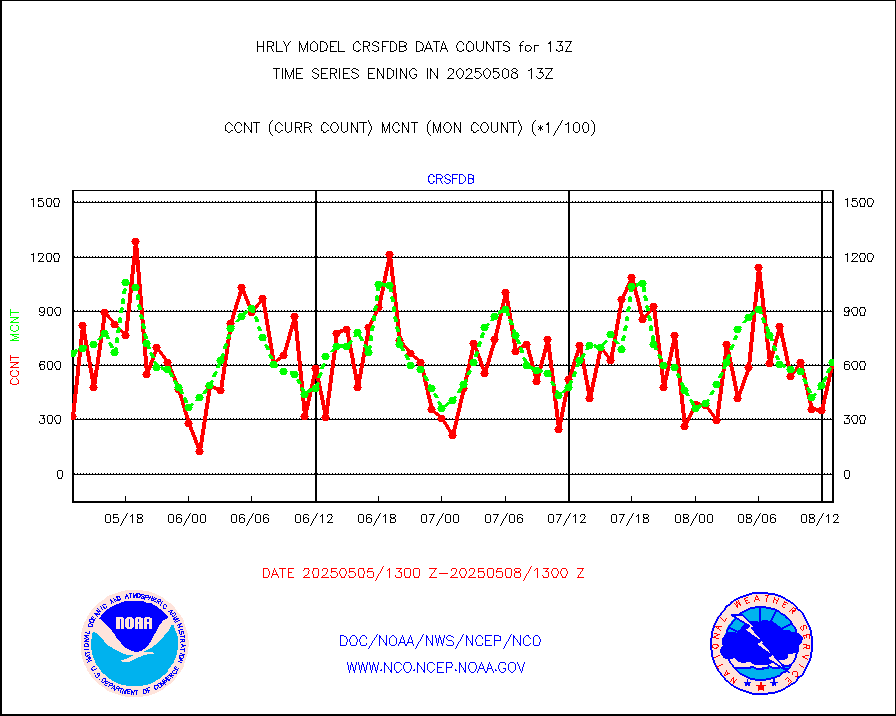
amsr2 |
GCOM-W AMSR2 1B brightness temperatures |
2309472 |
2051438 |
112.6 % |
1911.00-1911.99 |
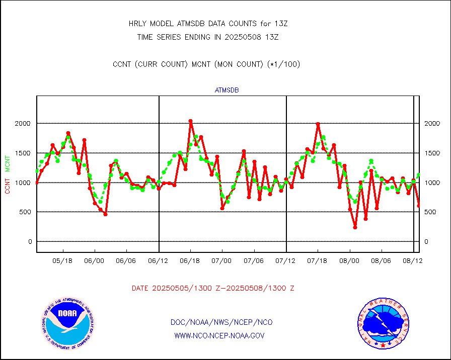
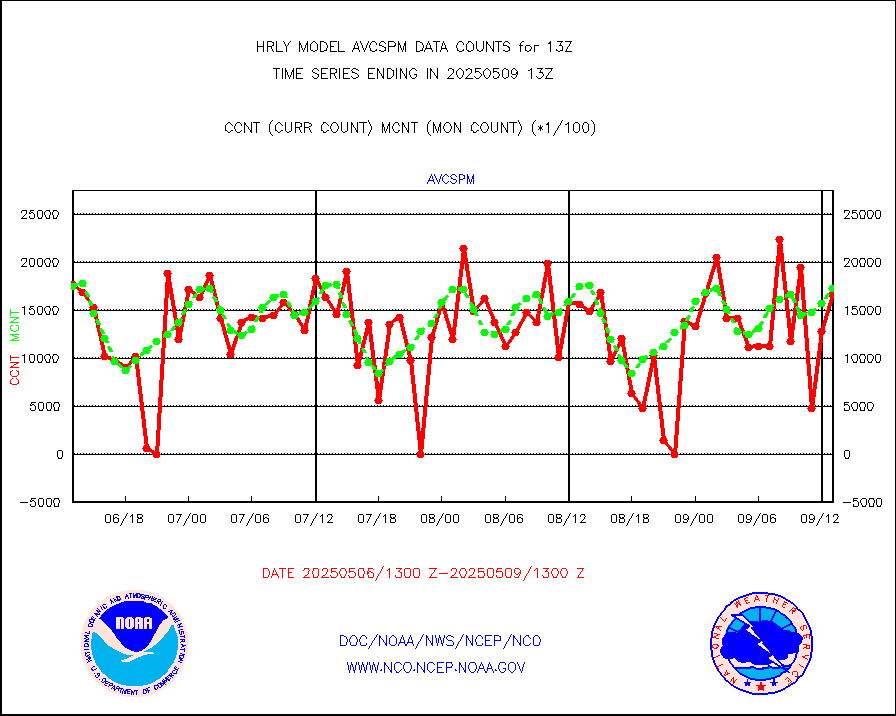
atmsdb |
NPP/NOAA-20 ATMS bright. temps-direct b-cast SSEC |
115200 |
123462 |
93.3 % |
1911.50-1912.49 |
atovs |
POES/NESDIS - processed ATOVS soundings/radiances |
0 |
0 |
n/a |
1911.00-1911.99 |
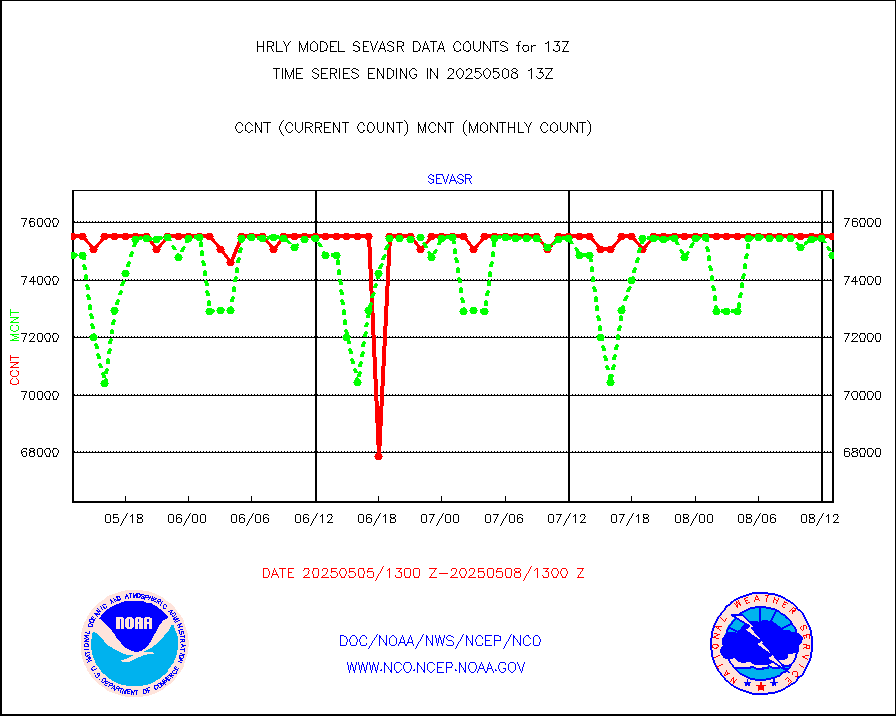
avcsam |
A.M.(N17,M2,M3) AVHRR GAC NCEP-proc clr&sea btmps |
1434425 |
1646406 |
87.1 % |
1910.50-1911.49 |
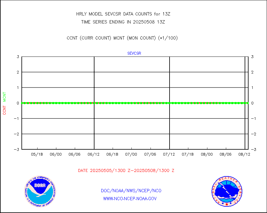
avcspm |
P.M.(N18-19) AVHRR GAC NCEP-proc clr & sea btemps |
1855878 |
1657398 |
112.0 % |
1910.50-1911.49 |
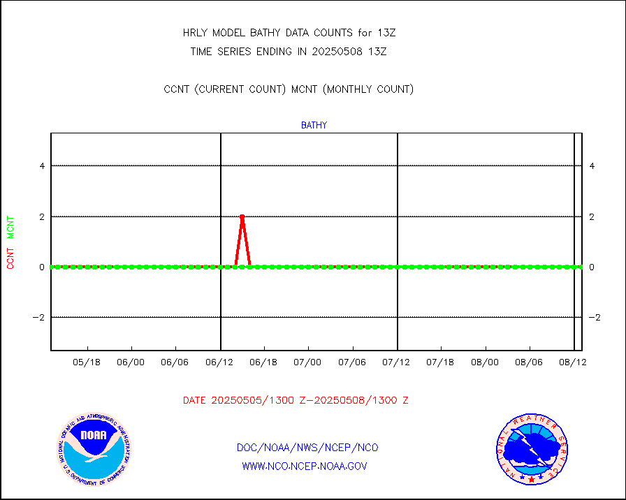
bathy |
eXpendable BathyThermograph, mooring (BATHY fmt) |
0 |
0 |
n/a |
1906.00-1906.99 |
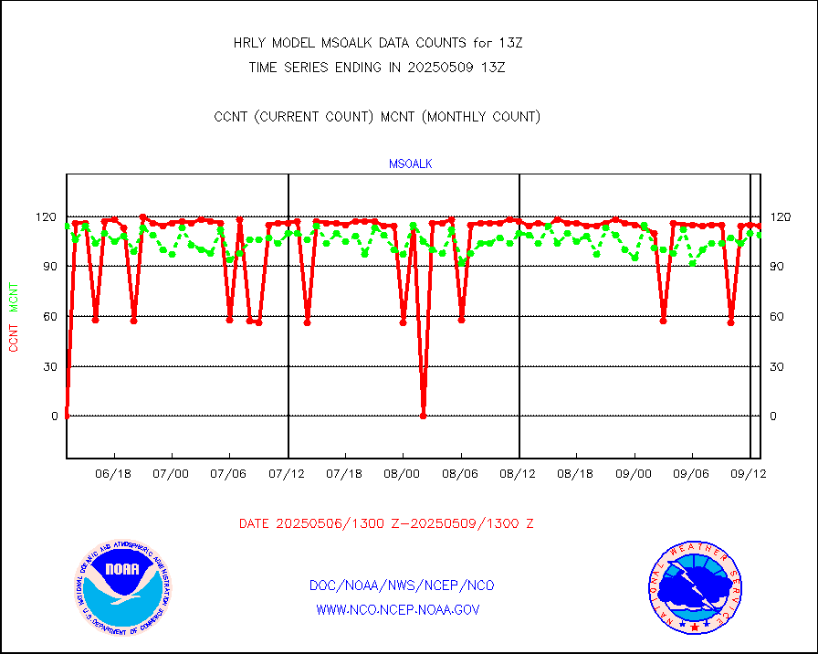
coopmd |
Coop/MADIS NEPP & HCN-Modernization NOAA COOP Obs |
27 |
27 |
100.0 % |
1912.50-1913.49 |
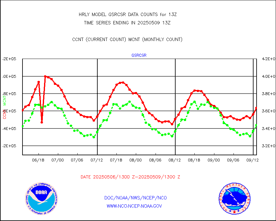
crisf4 |
NPP/NOAA-20 CrIS full spctrl radn (431 ch subset) |
240534 |
228472 |
105.3 % |
1911.50-1912.49 |
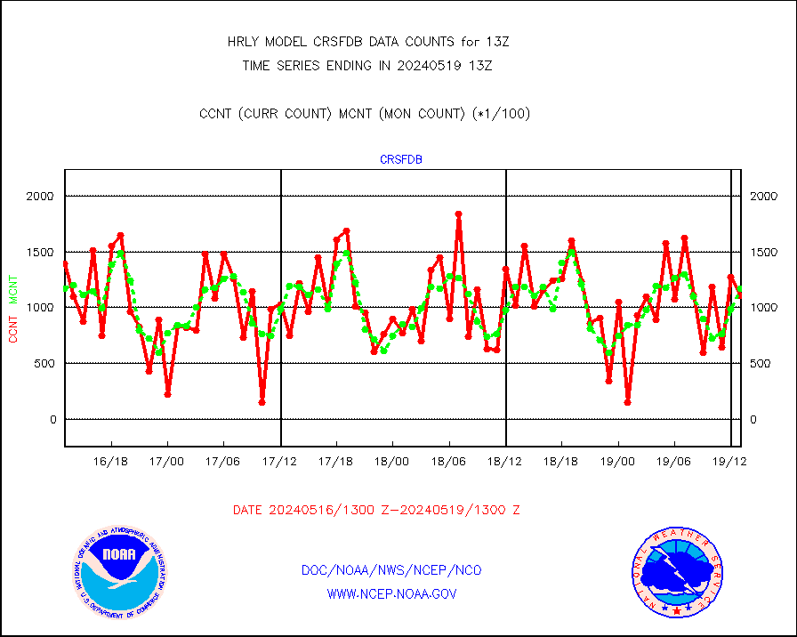
crsfdb |
NPP/NOAA-20 CrIS full spctrl radn dir brdcst SSEC |
110998 |
117428 |
94.5 % |
1911.50-1912.49 |
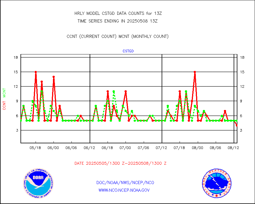
cstgd |
Coast Guard |
3 |
3 |
100.0 % |
1912.50-1913.50 |
dbuoyb |
Drifting buoys (decoded from BUFR) |
1445 |
1397 |
103.4 % |
1912.50-1913.50 |
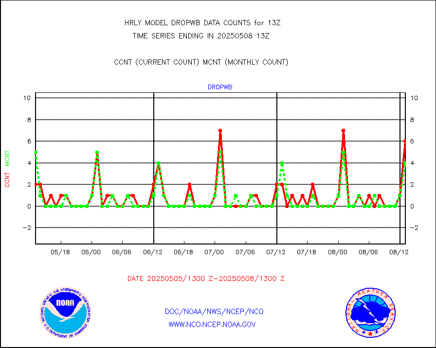
dropw |
Dropwinsonde (from TEMP DROP) |
0 |
0 |
n/a |
1912.50-1913.49 |
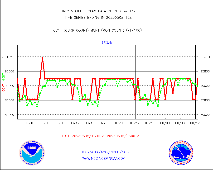
efclam |
GOES imager effective cloud amount data (U.Wisc.) |
8280985 |
8274014 |
100.1 % |
1912.50-1913.49 |
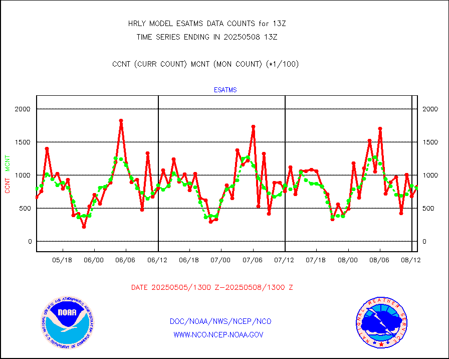
esatms |
NPP Adv. Tech. MW Sndr (ATMS) br. temps from RARS |
113130 |
84646 |
133.7 % |
1911.50-1912.49 |
esiasi |
METOP 1-2 IASI 1C radiance data vbl chn from RARS |
89355 |
88843 |
100.6 % |
1912.00-1912.99 |
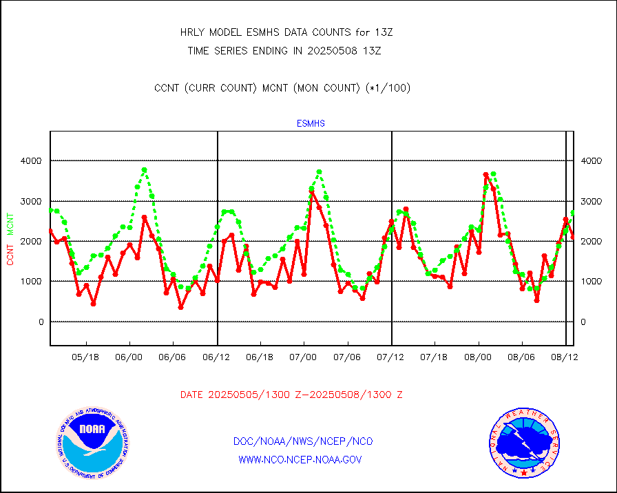
esmhs |
NOAA 18-19 & METOP 1-2 MHS proc. btemps from RARS |
279907 |
303416 |
92.3 % |
1912.50-1913.49 |
geoimr |
GOES/NESDIS (11x17 f-o-v) imager clear radiances |
0 |
0 |
n/a |
1912.00-1912.99 |
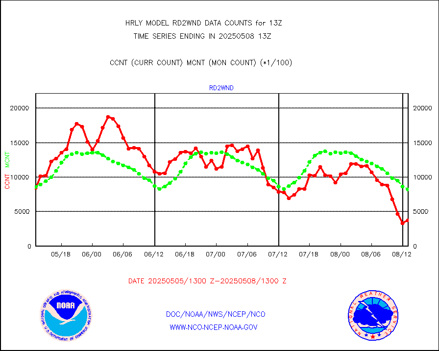
gome |
METOP 1-2 Global Ozone Monitoring Exp.-2 (GOME-2) |
9088 |
7192 |
126.4 % |
1911.50-1912.49 |
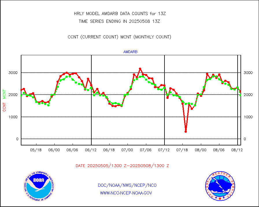
h20in2 |
INDIA SATWIND, INSAT WV channel |
5150 |
4866 |
105.8 % |
1912.00-1912.99 |
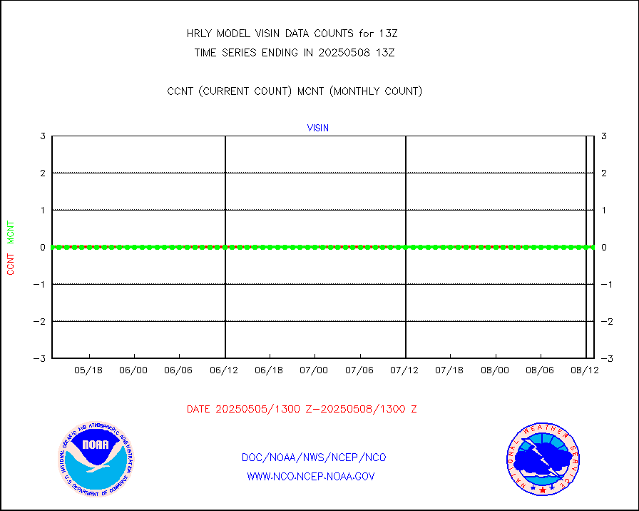
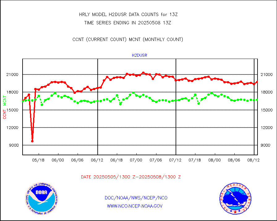
h2dusr |
GOES-16&up/NESDIS wv imgr/deep-lyr derivd cld mtn |
14638 |
15964 |
91.7 % |
1912.00-1912.99 |
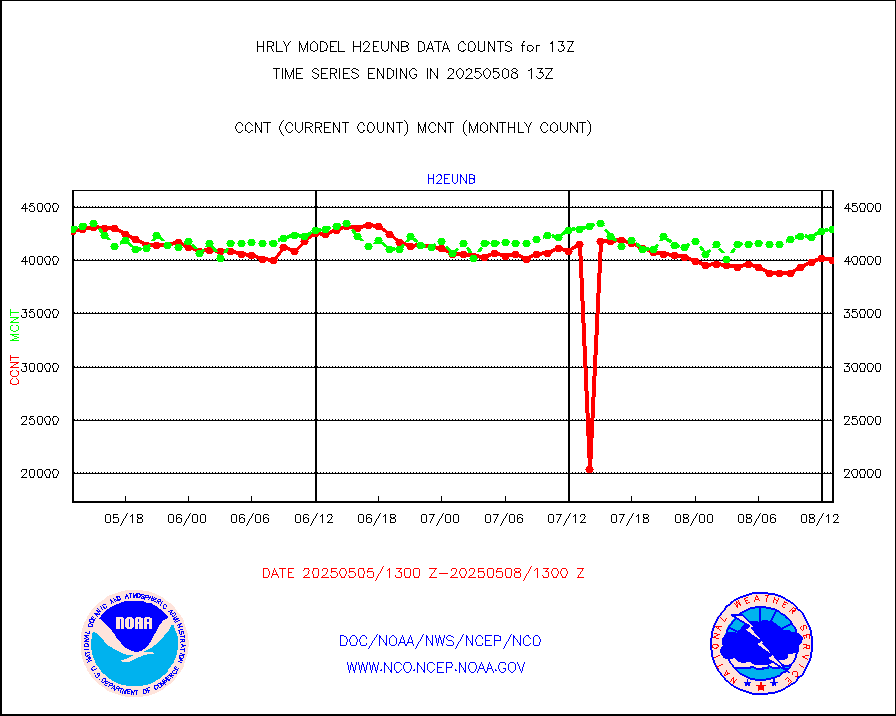
h2eunb |
METEOSAT/EUMETSAT wvpr imgr drv cld motion NBseq |
41497 |
42286 |
98.1 % |
1911.50-1912.49 |
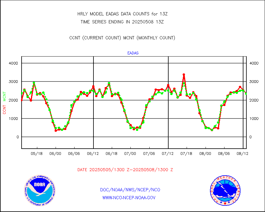
hdob |
High Density OBs from reconnaissance acft data |
0 |
0 |
n/a |
1912.50-1913.49 |
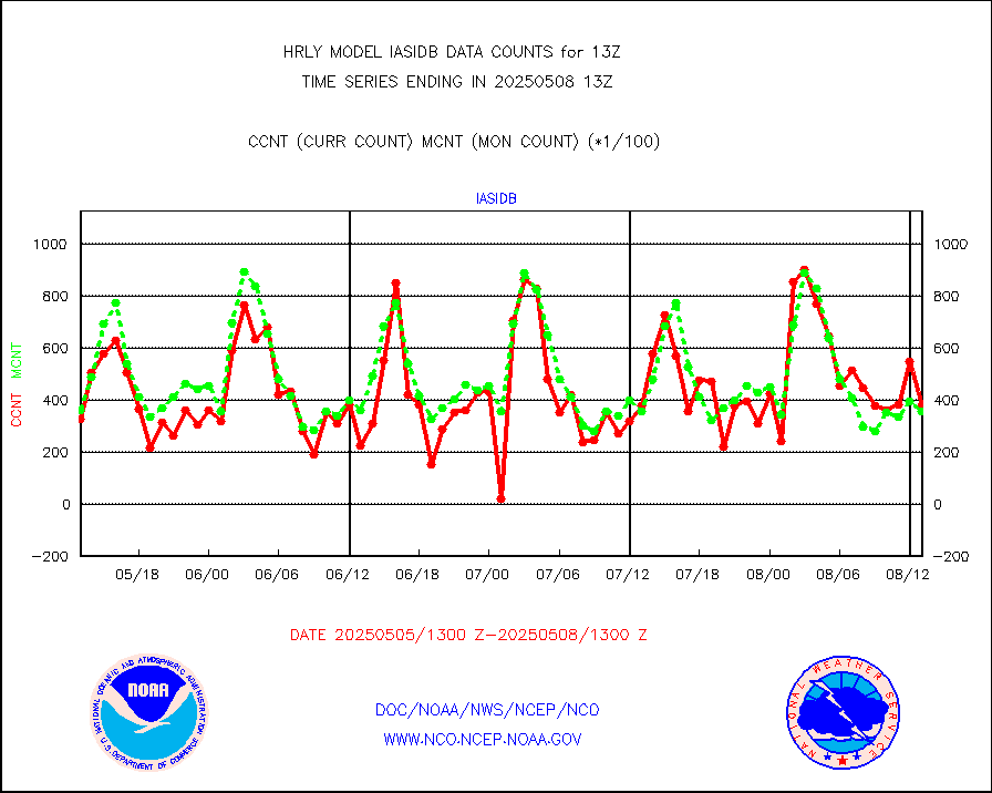
iasidb |
METOP 1-2 IASI 1C radiances-direct broadcast SSEC |
21360 |
19358 |
110.3 % |
1911.50-1912.49 |
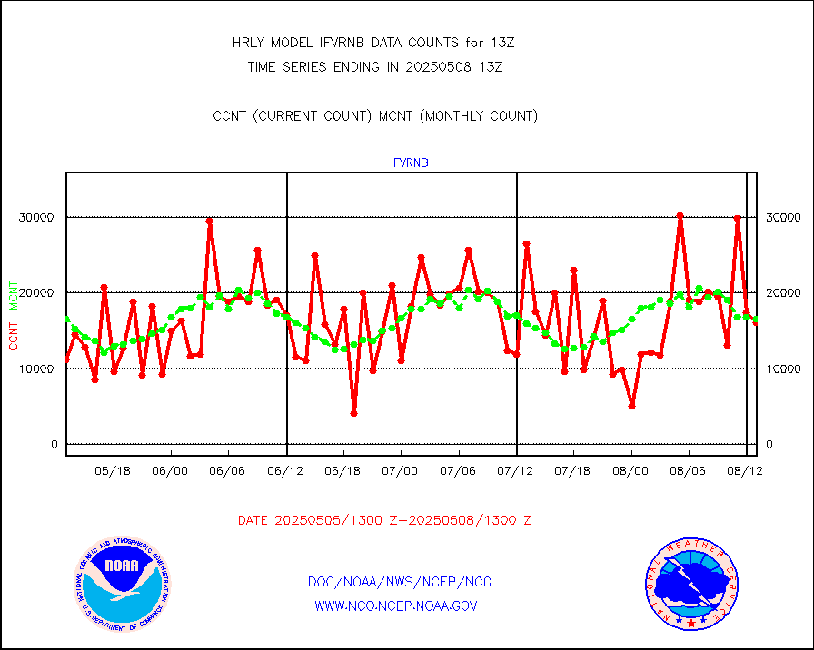
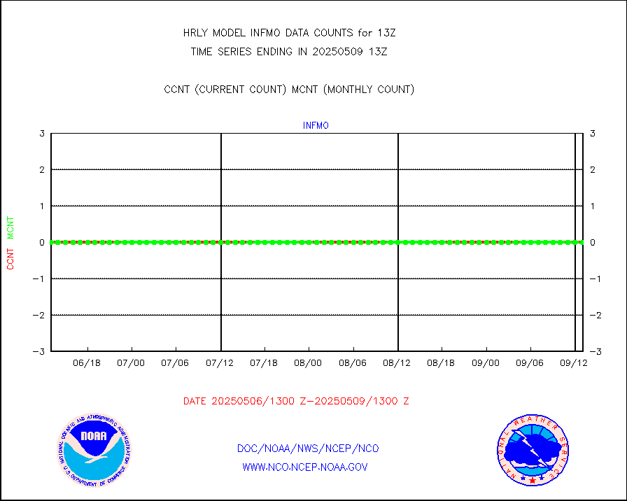
ifvrnb |
VIIRS (NPP/NOAA-20) ir lg-wv drv cloud motion(NB) |
15216 |
15106 |
100.7 % |
1909.00-1909.99 |
infav |
AVHRR (NOAA/METOP) ir lg-wave derived cld motion |
0 |
0 |
n/a |
1909.00-1909.99 |
infav1 |
AVHRR (METOP) ir lg-wave derived cld motion |
0 |
0 |
n/a |
1912.50-1913.50 |
infin |
INSAT/KALPANA India ir lg-wave derived cld motion |
0 |
0 |
n/a |
1910.50-1911.49 |
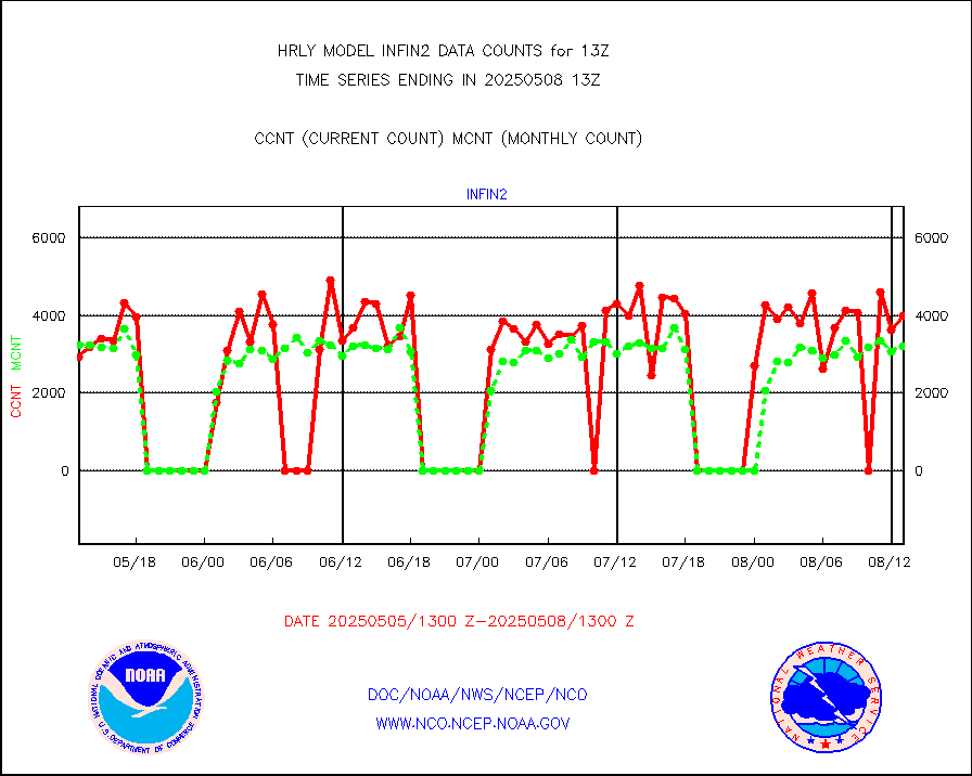
infin2 |
INDIA SATWIND, INSAT IR channel |
4994 |
4532 |
110.2 % |
1912.00-1912.99 |
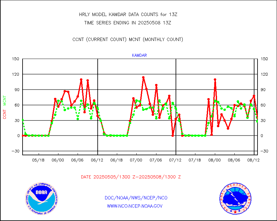
kamdar |
Korean AMDAR aircraft data (decoded from BUFR) |
52 |
30 |
173.3 % |
1912.50-1913.49 |
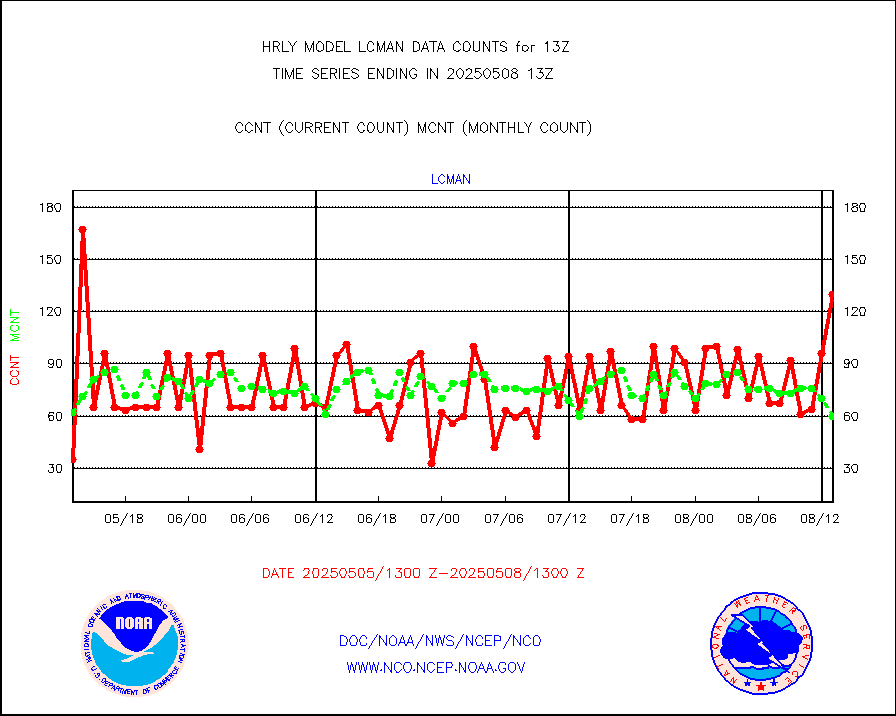
lcman |
Land-based CMAN stations decoded from CMAN format |
89 |
86 |
103.5 % |
1912.50-1913.49 |
leogeo |
LEO-GEO satellite AMVs from UWisc. |
6515 |
5257 |
123.9 % |
1909.00-1909.99 |
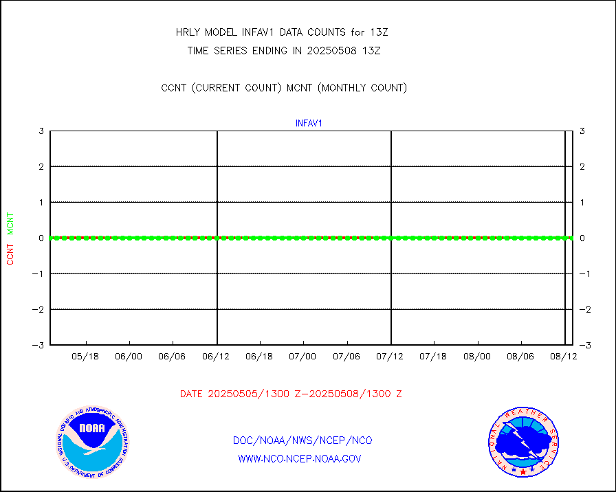
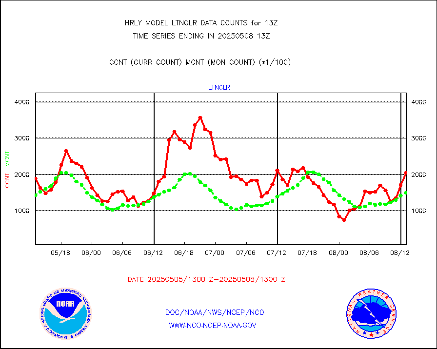
ltnglr |
LLDN Long-rng lightning from Vaisala via NOAAPORT |
217511 |
152339 |
142.8 % |
1912.50-1913.49 |
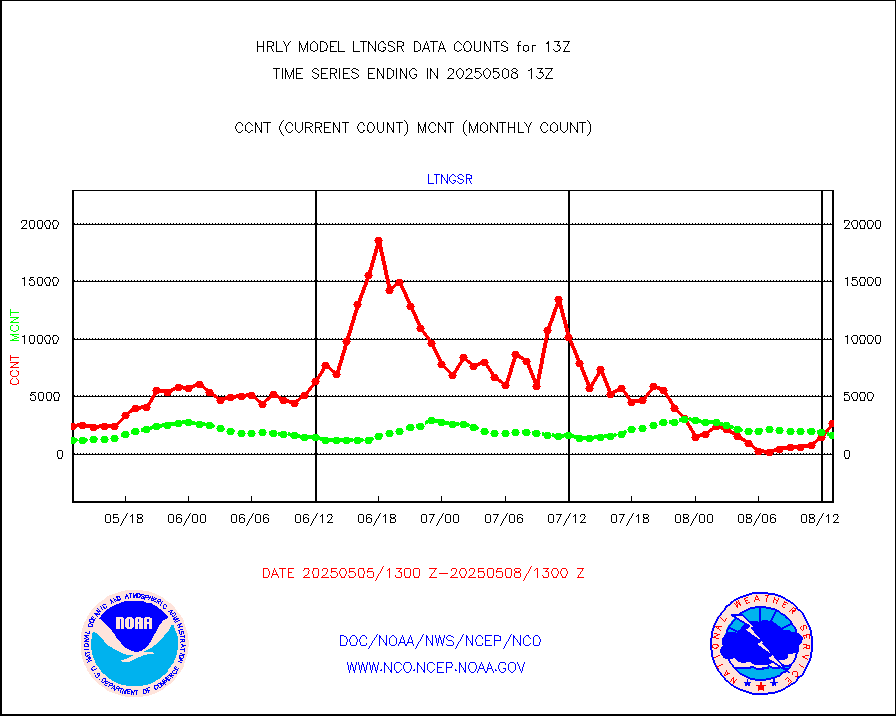
ltngsr |
NLDN Shrt-rng lightning from Vaisala via NOAAPORT |
4999 |
2710 |
184.5 % |
1912.50-1913.49 |
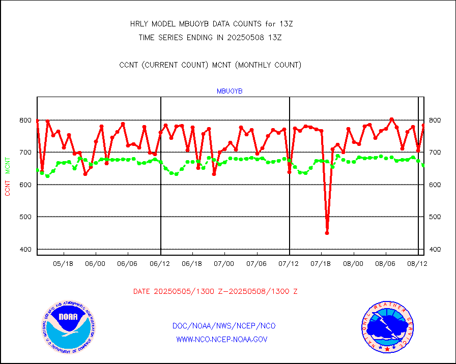
mbuoyb |
Moored buoys (decoded from BUFR) |
834 |
748 |
111.5 % |
1912.50-1913.50 |
mls |
Aura Microwave Limb Sounder (MLS) ozone data |
0 |
0 |
n/a |
1911.00-1911.99 |
msourb |
Mesonet/MADIS UrbaNet |
4272 |
4344 |
98.3 % |
1912.50-1913.49 |
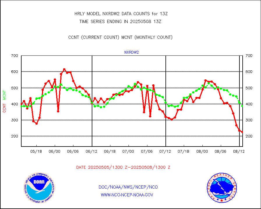
nxrdw2 |
NEXRAD Vel Azm Dsp(VAD) winds via Level 2 decoder |
508 |
428 |
118.7 % |
1912.50-1913.49 |
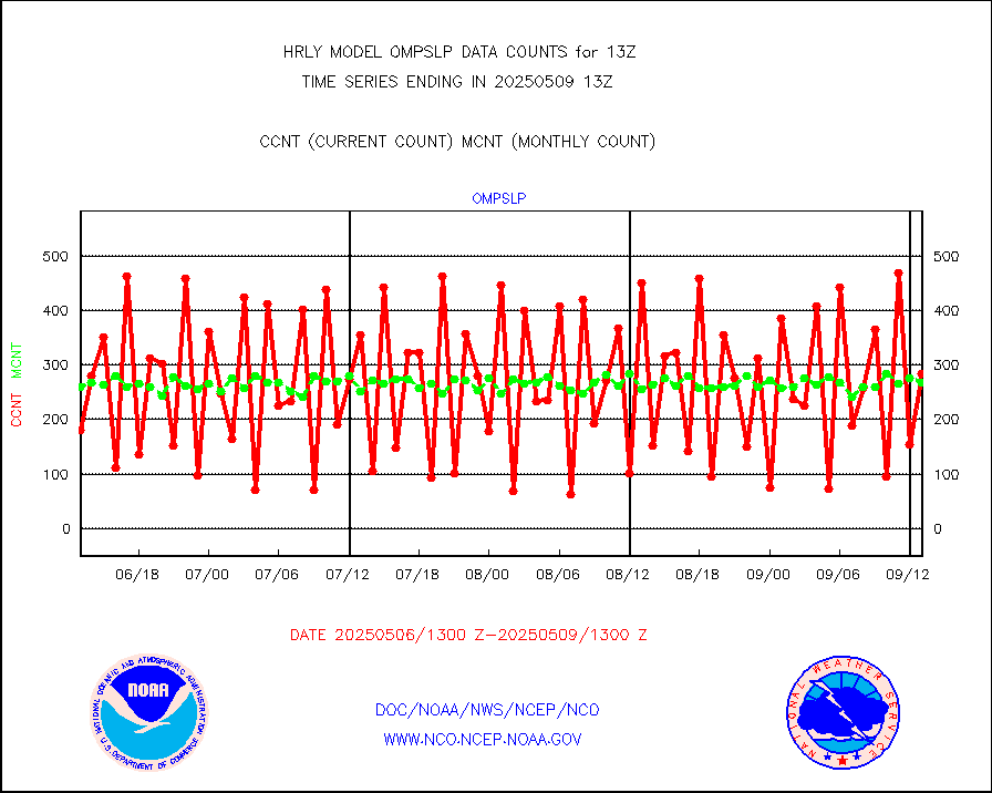
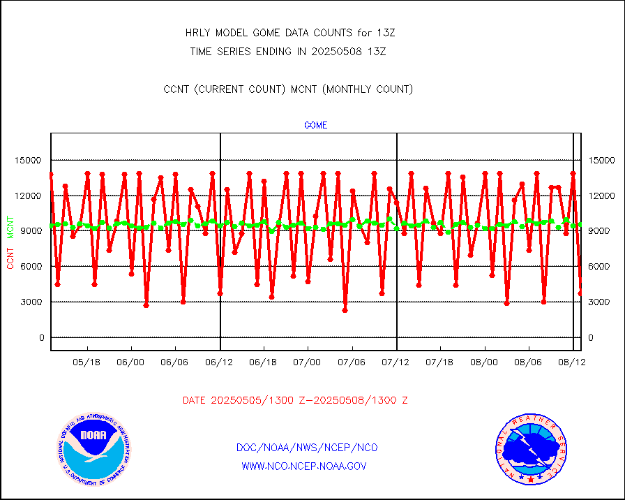
ompslp |
OMPS Limb Profiler ozone data (NPP) |
179 |
231 |
77.5 % |
1906.00-1906.99 |
ompsn8 |
OMPS nadir profile ozone (Version 8 BUFR) |
541 |
565 |
95.8 % |
1911.00-1911.99 |
ompst8 |
OMPS total column ozone (Version 8 BUFR) |
459059 |
334067 |
137.4 % |
1911.00-1911.99 |
pirep |
Manual PIREP aircraft data (dcded from AIREP fmt) |
105 |
142 |
73.9 % |
1912.50-1913.49 |
prflrp |
Profilr winds from PIBAL (PILOT,PILOT SHIP/MOBIL) |
0 |
0 |
n/a |
1912.50-1913.49 |
raobm |
Rawinsonde - mobile land (from TEMP/PILOT MOBIL) |
0 |
0 |
n/a |
1912.50-1913.49 |
raobs |
Rawinsonde - ship (from TEMP SHIP, PILOT SHIP) |
0 |
0 |
n/a |
1912.50-1913.49 |
recco |
Flight level reconnaissance aircraft data |
0 |
0 |
n/a |
1912.50-1913.49 |
saphir |
Megha-Tropiques SAPHIR L1A2 brightness temps |
0 |
0 |
n/a |
1910.50-1911.49 |
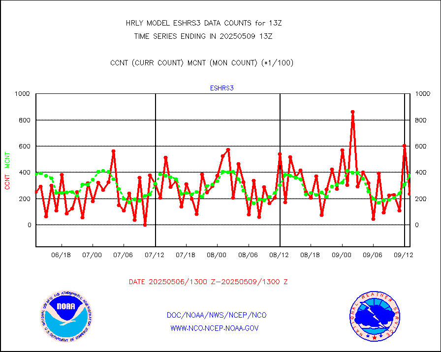
sevasr |
METEOSAT-10 2nd Gen SEVIRI All Sky Radiance(proc) |
75062 |
75467 |
99.5 % |
1912.50-1913.49 |
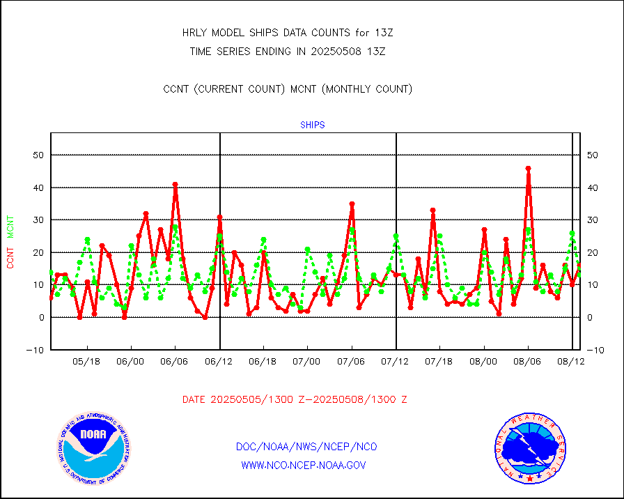
ships |
Ship - manual and automatic, restricted |
12 |
5 |
240.0 % |
1912.50-1913.49 |
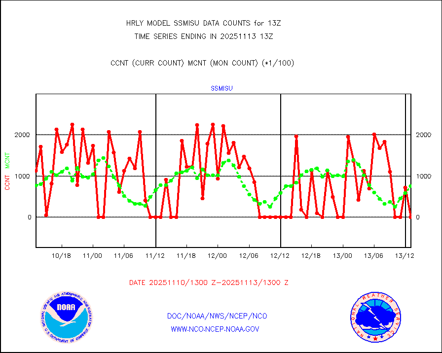
ssmisu |
DMSP SSM/IS 1C radiance data (Unified Pre-Proc.) |
8100 |
105426 |
7.7 % |
1911.50-1912.49 |
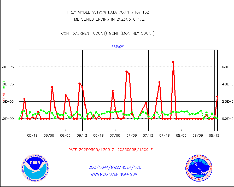
sstvcw |
NPP/NOAA-20 VIIRS SST - CLEAR & OVER WATER |
1649018 |
577116 |
285.7 % |
1912.50-1913.49 |
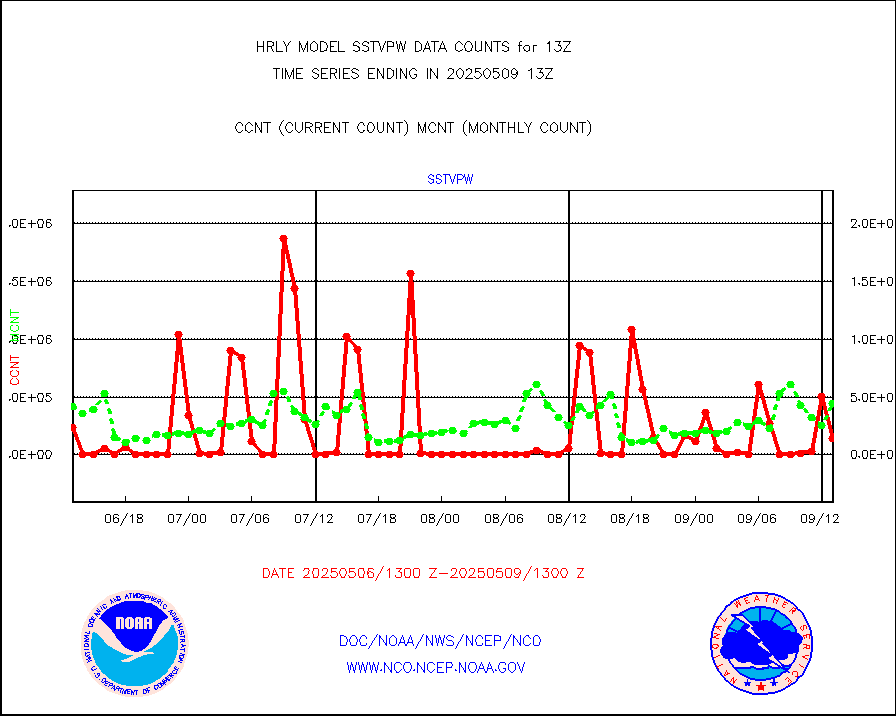
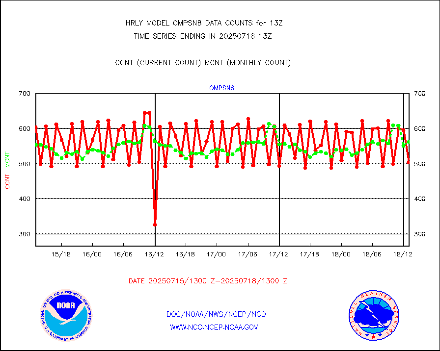
sstvpw |
NPP/NOAA-20 VIIRS SST - PROBABLY CLR & OVER WATER |
253144 |
138431 |
182.9 % |
1912.50-1913.49 |
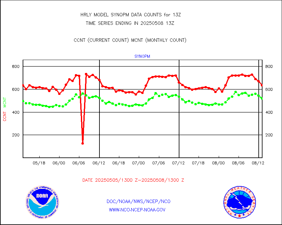
synopm |
Synoptic - mobile manual and automatic |
628 |
493 |
127.4 % |
1912.50-1913.49 |
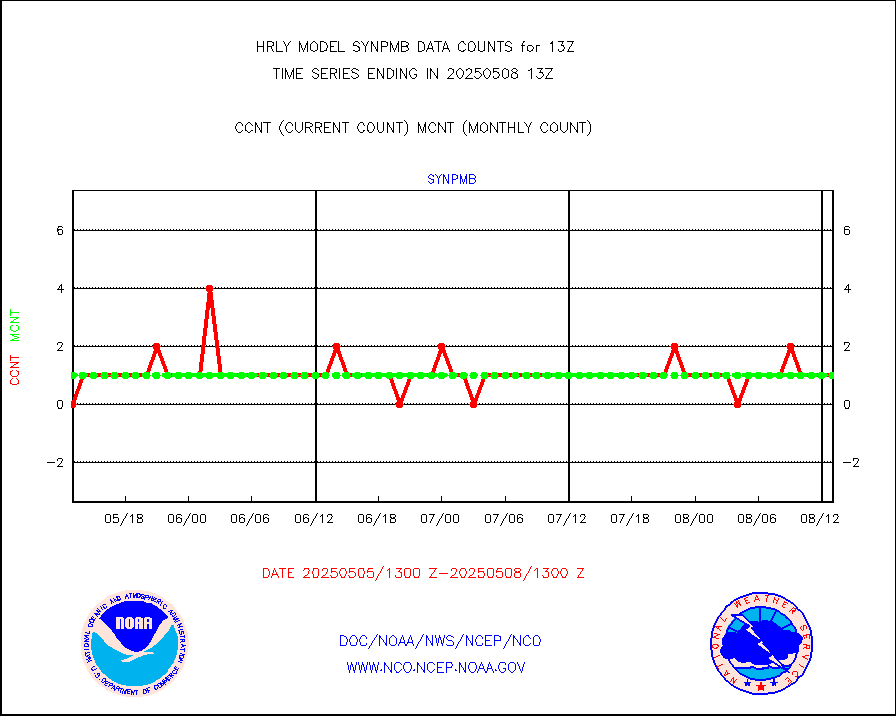
synpmb |
Synoptic - mobile manual & auto (decoded fr BUFR) |
0 |
1 |
0.0 % |
1912.50-1913.49 |
tesac |
CTD probe, Argo prflng float, mooring (TESAC fmt) |
205 |
196 |
104.6 % |
1912.50-1913.49 |
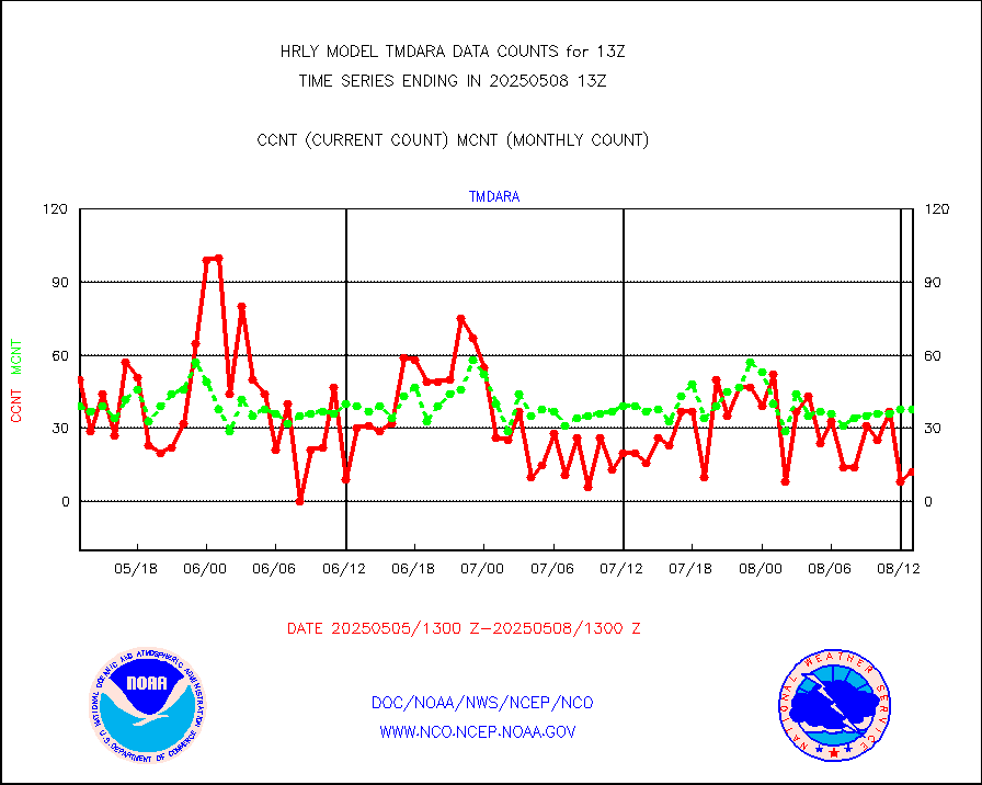
tmdara |
TAMDAR aircft data-all types(from Panasonic,BUFR) |
361 |
364 |
99.2 % |
1912.50-1913.49 |
trkob |
ThermoSalinoGraph (TSG) TRACKOB format) |
90 |
44 |
204.5 % |
1911.50-1912.49 |
visin |
INSAT/KALPANA India visible derived cloud motion |
0 |
0 |
n/a |
1910.50-1911.49 |
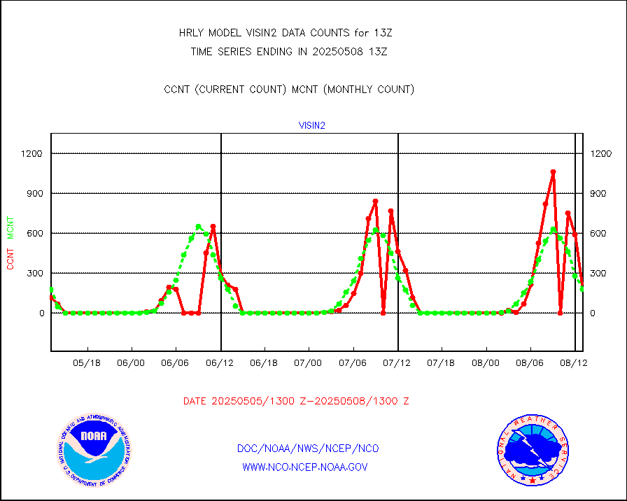
visin2 |
INDIA SATWIND, INSAT VIS channel |
132 |
284 |
46.5 % |
1912.00-1912.99 |
visja |
MTSAT/JMA visible derived cloud motion |
918 |
797 |
115.2 % |
1910.50-1911.49 |
visusr |
GOES-16&up/NESDIS visible derived cloud motion |
75669 |
68476 |
110.5 % |
1912.00-1912.99 |
vseunb |
METEOSAT/EUMETSAT visible drv cld motion NBseq |
38315 |
36498 |
105.0 % |
1911.50-1912.49 |


