| Critical Data with Normal Counts |
|---|
| Type | Description | Hourly Count | Monthly Average | Percent (%) of Monthly Mean | UTC Time Window |
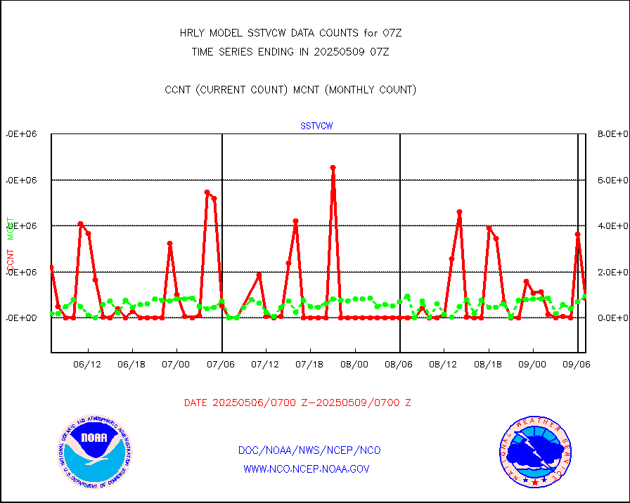
1bamua |
NOAA 15-19 & METOP 1-2 AMSU-A NCEP-proc. br.temps |
36836 |
49826 |
73.9 % |
1905.00-1905.99 |
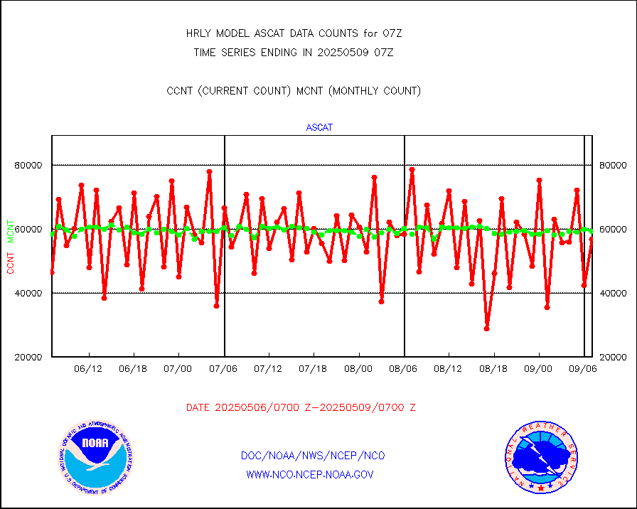
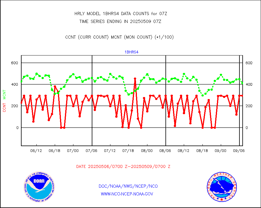
1bhrs4 |
NOAA 18-19 & METOP 1-2 HIRS-4 NCEP-proc. br.temps |
29624 |
44070 |
67.2 % |
1905.00-1905.99 |
1bmhs |
NOAA 18-19 & METOP 1-2 MHS NCEP-proces. br. temps |
186336 |
296936 |
62.8 % |
1905.00-1905.99 |
acars |
MDCRS ACARS acft data from ARINC(dcded from BUFR) |
3257 |
2608 |
124.9 % |
1906.50-1907.49 |
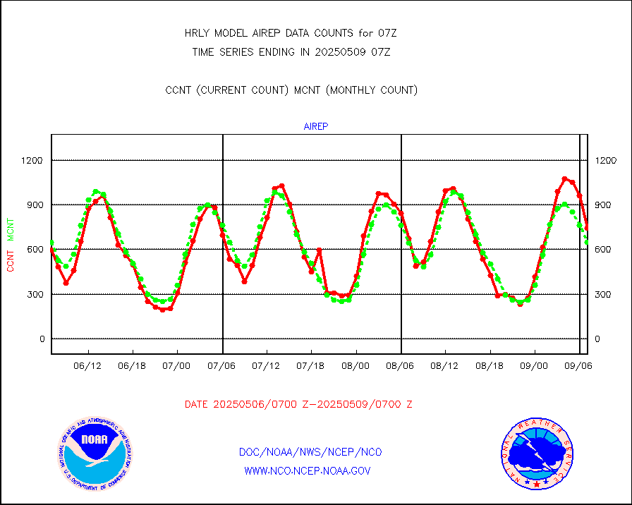
airep |
Manual AIREP aircraft data (dcded from AIREP fmt) |
1194 |
1106 |
108.0 % |
1906.50-1907.49 |
airsev |
AQUA AIRS/AMSU-A/HSB brightness temps- every FOV |
0 |
0 |
n/a |
1904.50-1905.49 |
amdar |
AMDAR aircraft data (decoded from AMDAR format) |
351 |
213 |
164.8 % |
1906.50-1907.49 |
amdarb |
AMDAR aircraft data (decoded from BUFR) |
1292 |
1292 |
100.0 % |
1906.50-1907.49 |
ascat |
METOP 1-2 ASCAT products |
46452 |
46687 |
99.5 % |
1905.50-1906.49 |
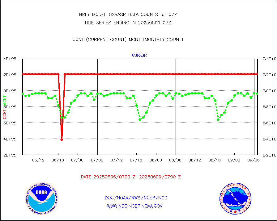
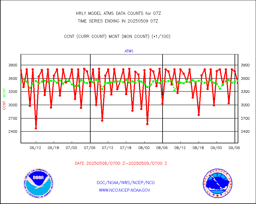
atms |
NPP/NOAA-20 ATMS brightness temperatures |
378528 |
349853 |
108.2 % |
1905.50-1906.49 |
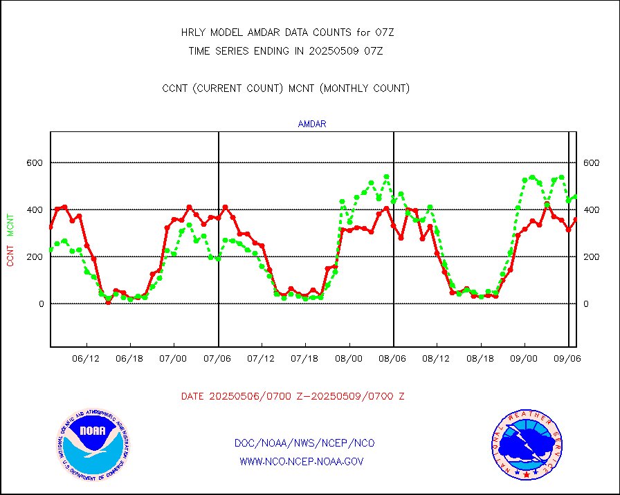
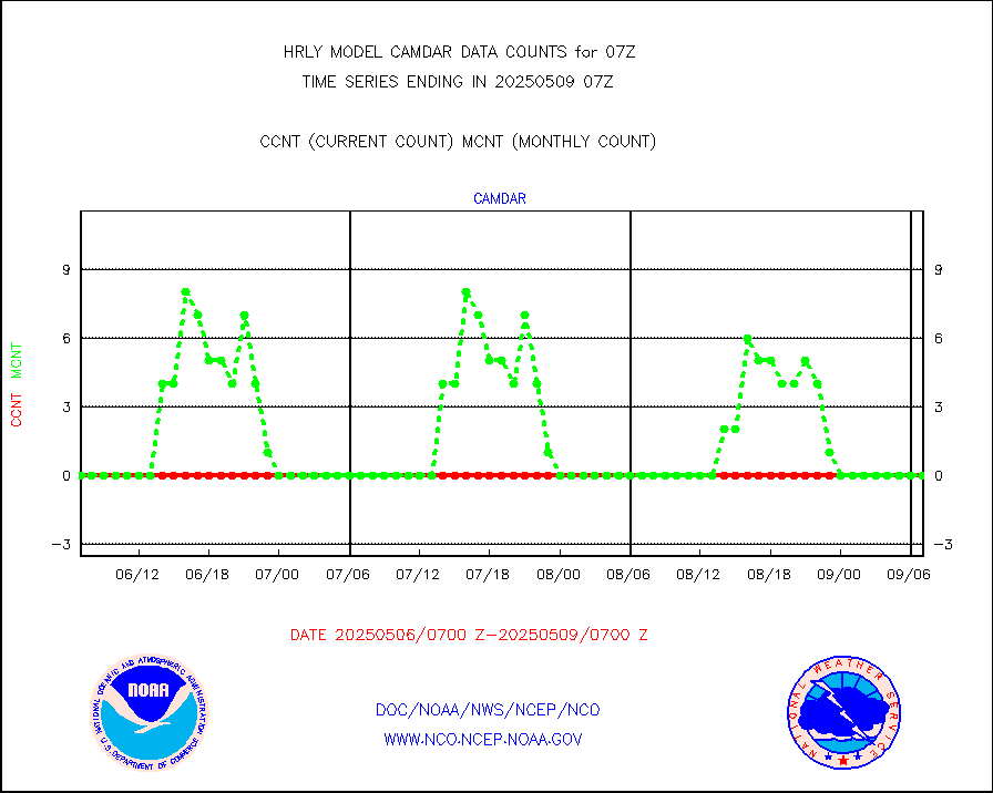
camdar |
Canadian AMDAR aircraft data (decoded from BUFR) |
0 |
0 |
n/a |
1906.50-1907.49 |
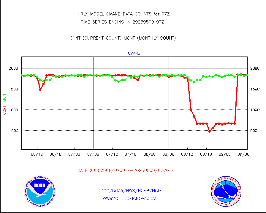
cmanb |
Surface Marine CMAN rpts decoded from BUFR format |
1820 |
1811 |
100.5 % |
1906.50-1907.50 |
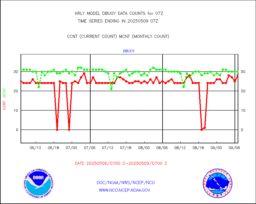
dbuoy |
Buoys decoded from FM-18 fmt (moored or drifting) |
40 |
39 |
102.6 % |
1906.50-1907.49 |
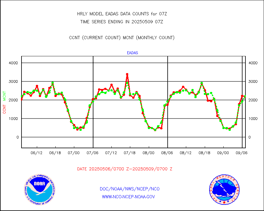
eadas |
E-AMDAR (European AMDAR acft decoded from BUFR) |
1672 |
1767 |
94.6 % |
1906.50-1907.49 |
esamua |
NOAA 15-19 & METOP 1-2 AMSU-A proc btmps frm RARS |
21751 |
15680 |
138.7 % |
1906.50-1907.49 |
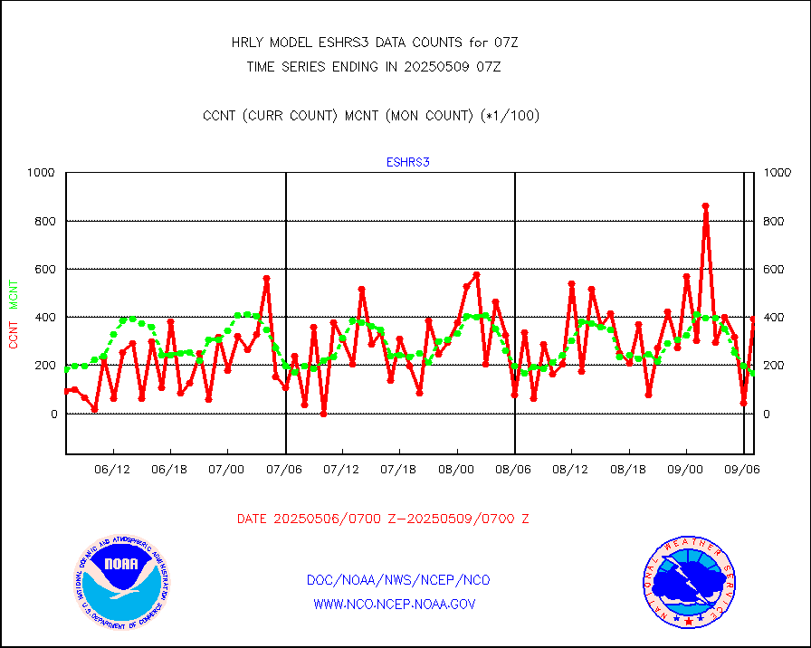
eshrs3 |
NOAA 15-19 & METOP 1-2 HIRS-3/4 pr btmps frm RARS |
42214 |
32743 |
128.9 % |
1906.50-1907.49 |
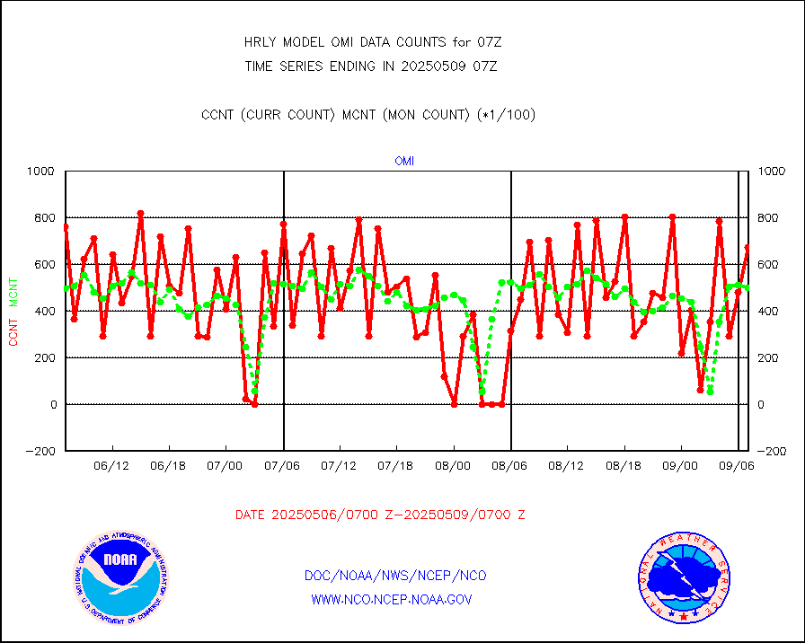
gnss |
Grnd-based Gbl Navigation Sat System (GNSS) data |
8861 |
9083 |
97.6 % |
1906.00-1906.99 |
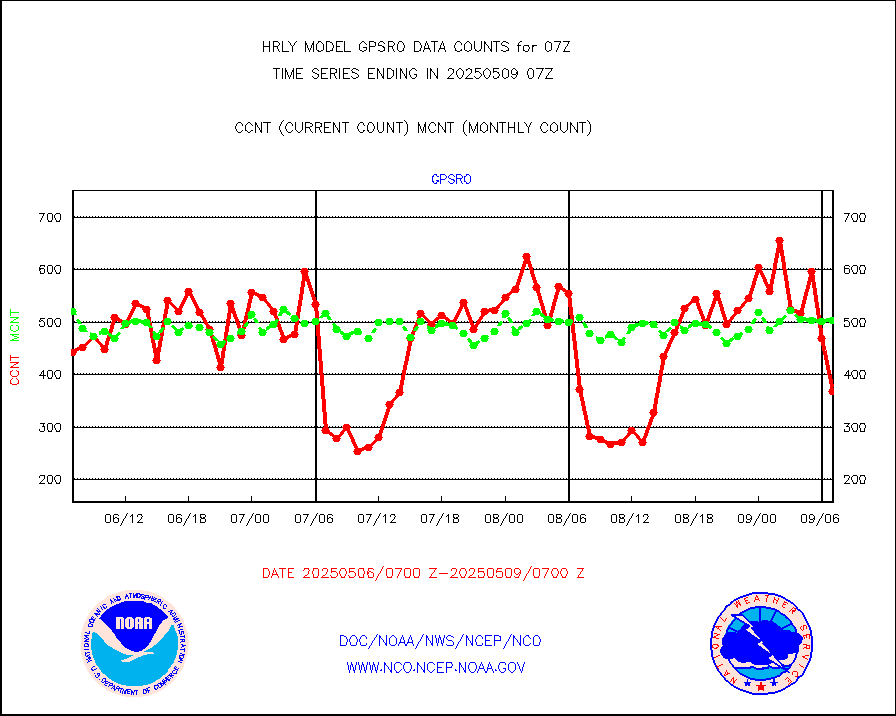
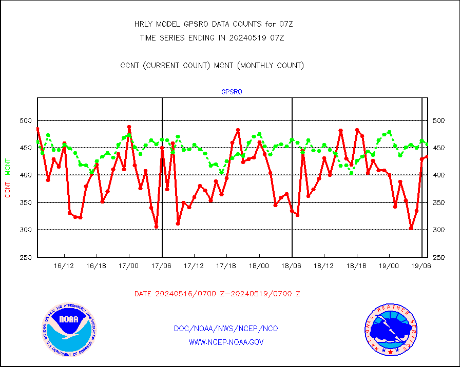
gpsro |
GPS radio occultation data |
434 |
457 |
95.0 % |
1904.50-1905.49 |
gsrasr |
GOES-16/17 All Sky Radiances (proc.) |
540714 |
533790 |
101.3 % |
1906.50-1907.49 |
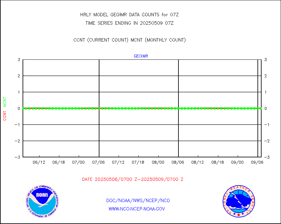
gsrcsr |
GOES-16/17 Clear Sky Radiances (proc.) |
244780 |
246073 |
99.5 % |
1906.50-1907.49 |
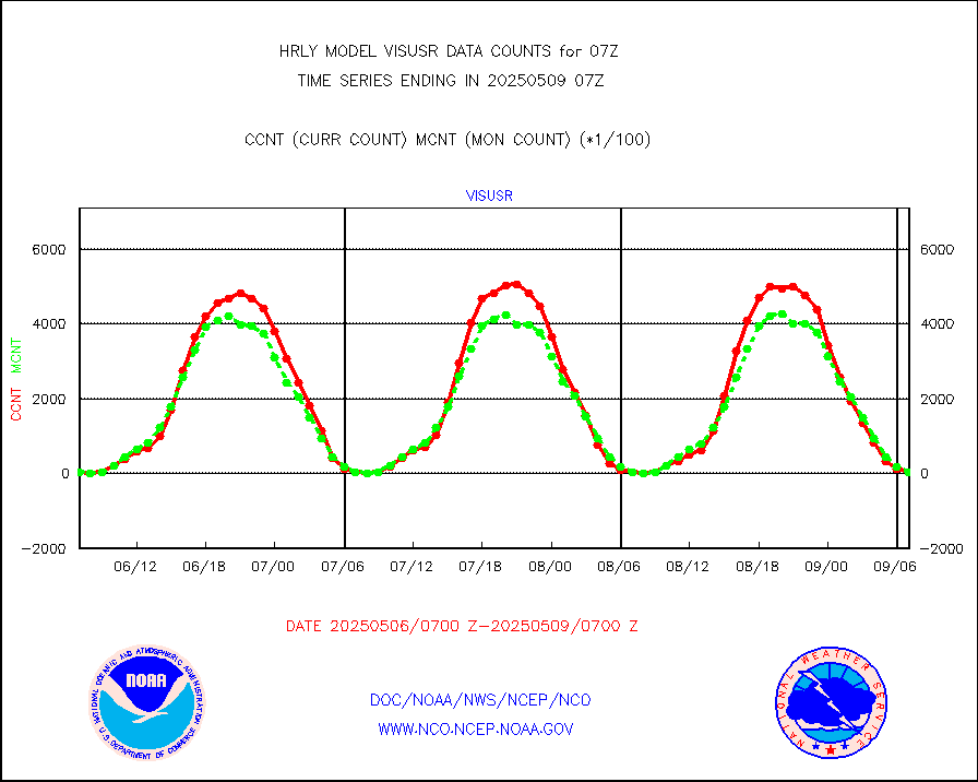
h20ja |
MTSAT/JMA water vapor imager derived cloud motion |
20177 |
19627 |
102.8 % |
1904.50-1905.49 |
h20mo |
MODIS (AQUA/TERRA) wvpr imager derived cld motion |
0 |
0 |
n/a |
1903.00-1903.99 |
h2tusr |
GOES-16&up/NESDIS wv imgr/cld-top derived cld mtn |
23034 |
26259 |
87.7 % |
1906.00-1906.99 |
ifeunb |
METEOSAT/EUMETSAT ir lg-wave drv cld motion NBseq |
21355 |
21340 |
100.1 % |
1905.50-1906.49 |
infja |
MTSAT/JMA infrared long-wave derived cloud motion |
14280 |
16157 |
88.4 % |
1904.50-1905.49 |
infmo |
MODIS (AQUA/TERRA) ir l-wave derived cloud motion |
0 |
0 |
n/a |
1903.00-1903.99 |
infusr |
GOES-16&up/NESDIS ir long-wave derived cld motion |
78476 |
78245 |
100.3 % |
1906.00-1906.99 |
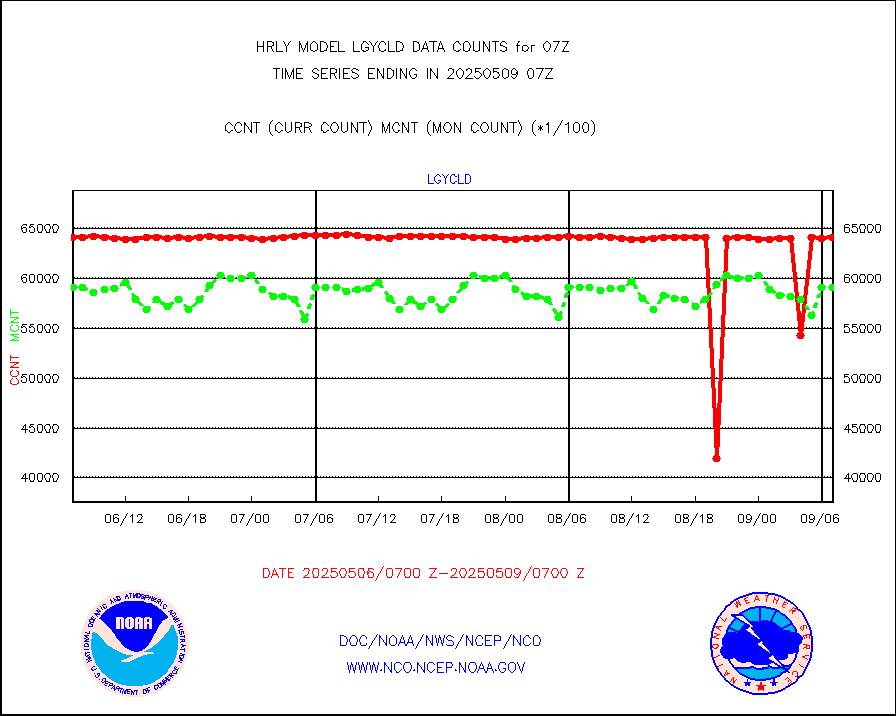
lgycld |
GOES/NASA(Langley) hi-res. (1x1 f-o-v) cloud data |
4222566 |
3515366 |
120.1 % |
1906.50-1907.49 |
mbuoy |
Buoys decoded from FM-13 format (moored) |
118 |
110 |
107.3 % |
1906.50-1907.49 |
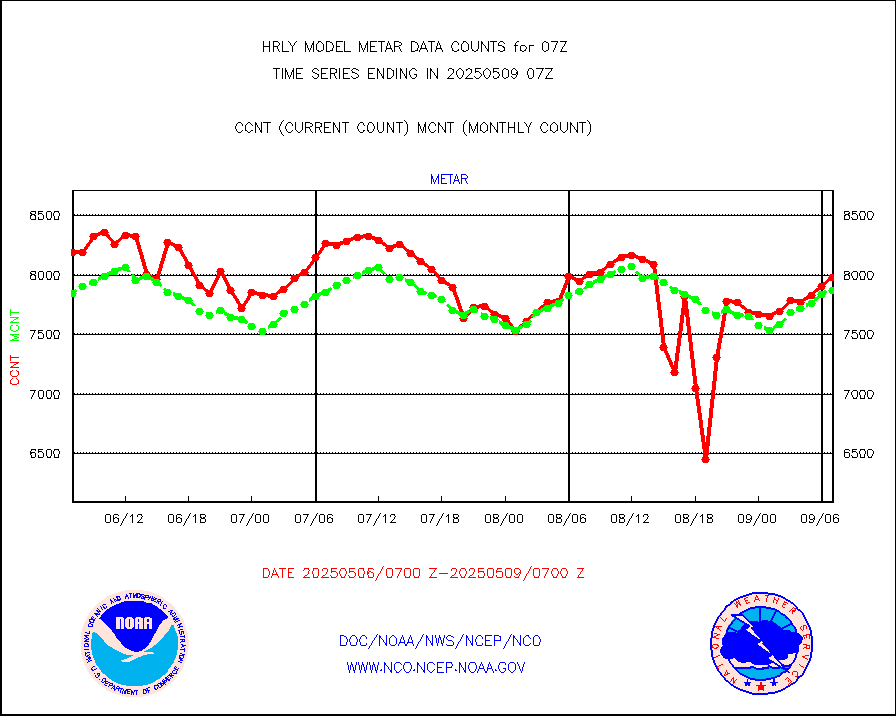
metar |
Aviation - METAR |
7666 |
7877 |
97.3 % |
1906.50-1907.49 |
mso470 |
Mesonet/MADIS Colorado E-470 (Interstate 470) |
21 |
20 |
105.0 % |
1906.50-1907.49 |
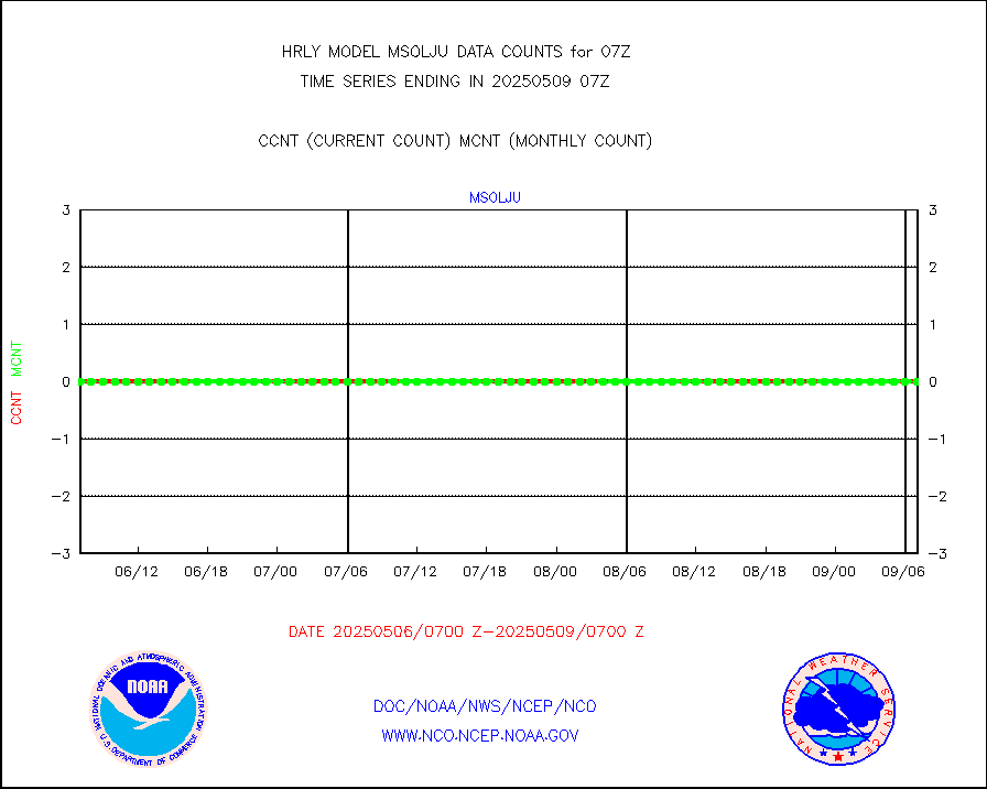
msoalk |
Mesonet/MADIS Alaska Department of Transportation |
106 |
107 |
99.1 % |
1906.50-1907.49 |
msoapg |
Mesonet/MADIS U.S. Army Aberdeen Proving Grounds |
0 |
0 |
n/a |
1906.50-1907.49 |
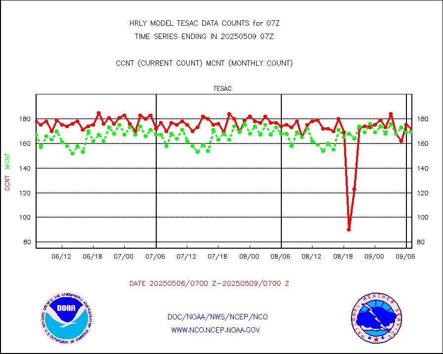
msoapr |
Mesonet/MADIS Citizen Weather Observers Program |
49705 |
48121 |
103.3 % |
1906.50-1907.49 |
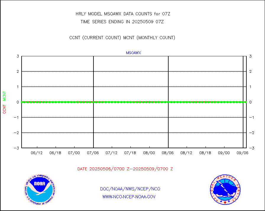
msoaws |
Mesonet/MADIS AWS Convergence Technologies, Inc. |
24812 |
25450 |
97.5 % |
1906.50-1907.49 |
msoawx |
Mesonet/MADIS "Anything Weather" |
0 |
0 |
n/a |
1906.50-1907.49 |
msocol |
Mesonet/MADIS Colorado Dept. of Transportation |
0 |
0 |
n/a |
1906.50-1907.49 |
msodcn |
Mesonet/MADIS DC Net |
0 |
0 |
n/a |
1906.50-1907.49 |
msoden |
Mesonet/MADIS Denver Urban Drainage & Flood Cntrl |
250 |
248 |
100.8 % |
1906.50-1907.49 |
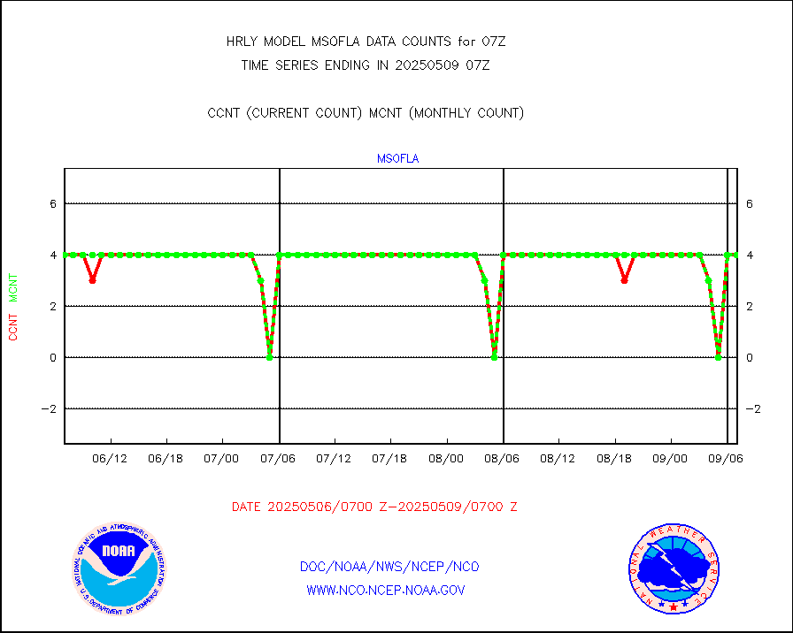
msofla |
Mesonet/MADIS Florida (FAWN & USF) |
4 |
4 |
100.0 % |
1906.50-1907.49 |
msoflt |
Mesonet/MADIS Florida Dept. of Transportation |
0 |
0 |
n/a |
1906.50-1907.49 |
msogeo |
Mesonet/MADIS Georgia Dept. of Transportation |
0 |
0 |
n/a |
1906.50-1907.49 |
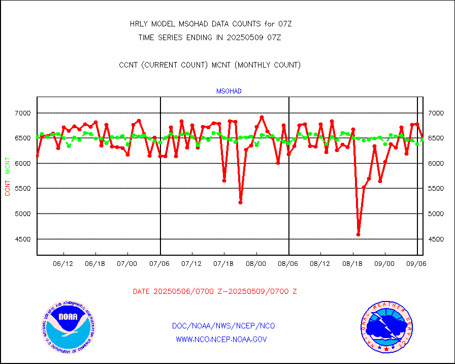
msohad |
Mesonet/MADIS NWS Hydromet Auto Data System(HADS) |
6862 |
6783 |
101.2 % |
1906.50-1907.49 |
msoien |
Mesonet/MADIS Iowa Environmental |
183 |
185 |
98.9 % |
1906.50-1907.49 |
msoind |
Mesonet/MADIS Indiana Dept. of Transportation |
0 |
0 |
n/a |
1906.50-1907.49 |
msoiow |
Mesonet/MADIS Iowa Department of Transportation |
0 |
0 |
n/a |
1906.50-1907.49 |
msokan |
Mesonet/MADIS Kansas Department of Transportation |
347 |
364 |
95.3 % |
1906.50-1907.49 |
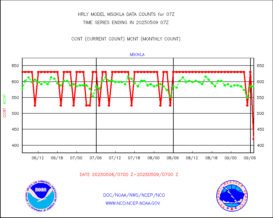
msokla |
Mesonet/MADIS Oklahoma Mesonet |
318 |
318 |
100.0 % |
1906.50-1907.49 |
msolju |
Mesonet/MADIS Louisiana State/Jackson State Univ. |
0 |
0 |
n/a |
1906.50-1907.49 |
msomca |
Mesonet/MADIS Missouri Commercial Agricult Wx Net |
287 |
295 |
97.3 % |
1906.50-1907.49 |
msomin |
Mesonet/MADIS Minnesota Dept. of Transportation |
0 |
0 |
n/a |
1906.50-1907.49 |
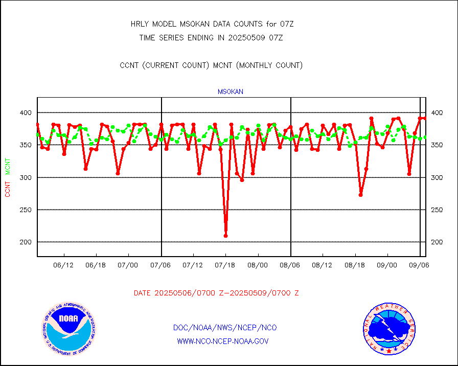
msonos |
Mesonet/MADIS NOS-Phys Oceanographic Realtime Sys |
389 |
383 |
101.6 % |
1906.50-1907.49 |
msoraw |
Mesonet/MADIS NFIC Remote Automated Wx Stns(RAWS) |
1945 |
1815 |
107.2 % |
1906.50-1907.49 |
msovir |
Mesonet/MADIS Virginia Dept. of Transportation |
207 |
225 |
92.0 % |
1906.50-1907.49 |
msowfy |
Mesonet/MADIS "Weather for You" |
0 |
0 |
n/a |
1906.50-1907.49 |
msowis |
Mesonet/MADIS Wisconsin Dept. of Transportation |
0 |
0 |
n/a |
1906.50-1907.49 |
msowst |
Mesonet/MADIS MesoWest (many subproviders) |
46939 |
45986 |
102.1 % |
1906.50-1907.49 |
msowtx |
Mesonet/MADIS West Texas |
5653 |
5610 |
100.8 % |
1906.50-1907.49 |
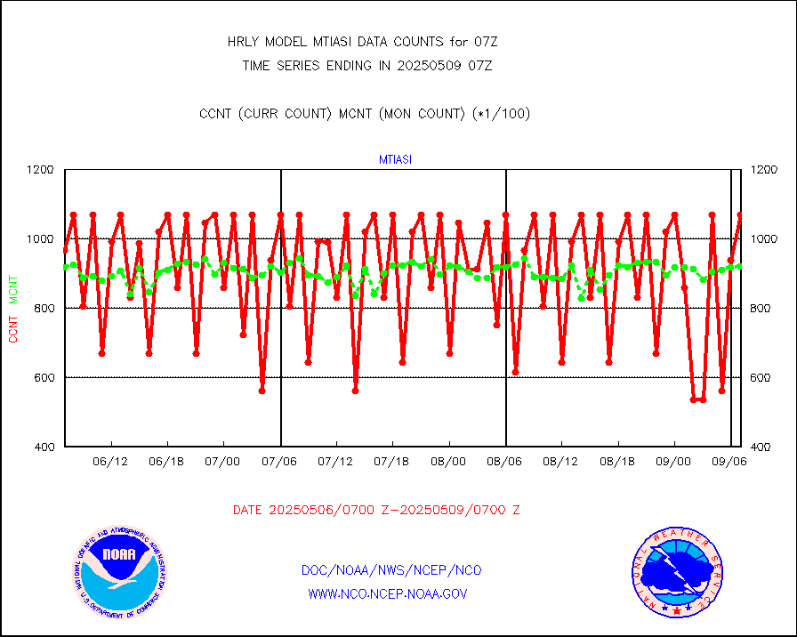
mtiasi |
METOP 1-2 IASI 1C radiance data (varbl. channels) |
80416 |
78656 |
102.2 % |
1905.00-1905.99 |
nxrdw |
NEXRAD Vel Azm Dsp(VAD) winds via radar coded msg |
0 |
0 |
n/a |
1906.50-1907.49 |
omi |
Aura Ozone Monitoring Instrument (OMI) data |
0 |
30866 |
0.0 % |
1904.50-1905.49 |
osbuv8 |
NOAA 16-19 Solar Backscatter UV-2 rad frm V8 BUFR |
0 |
0 |
n/a |
1905.00-1905.99 |
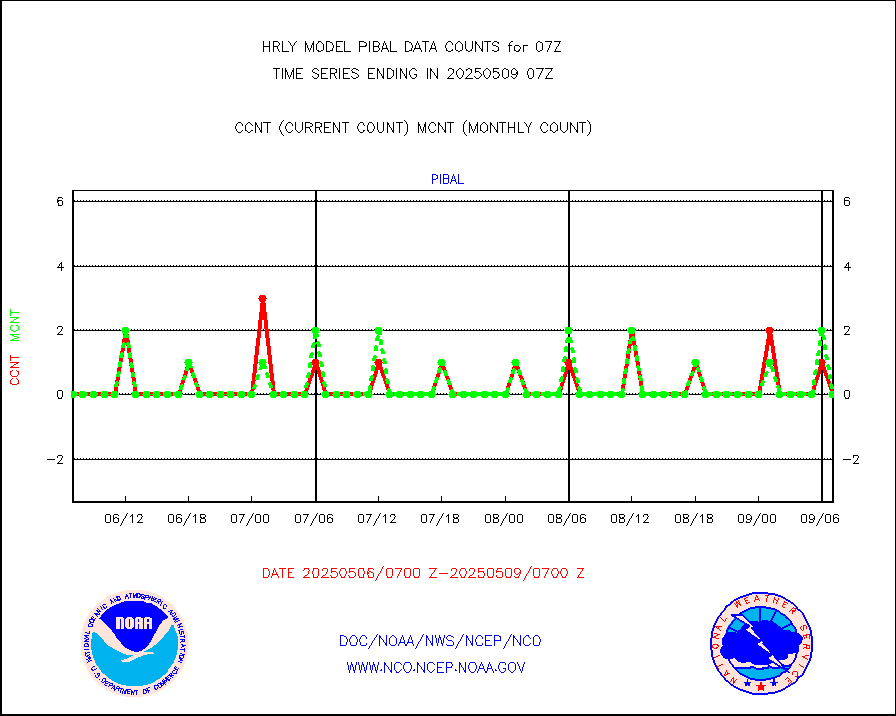
pibal |
PIBAL (from PILOT, PILOT SHIP, PILOT MOBIL) |
0 |
0 |
n/a |
1906.50-1907.49 |
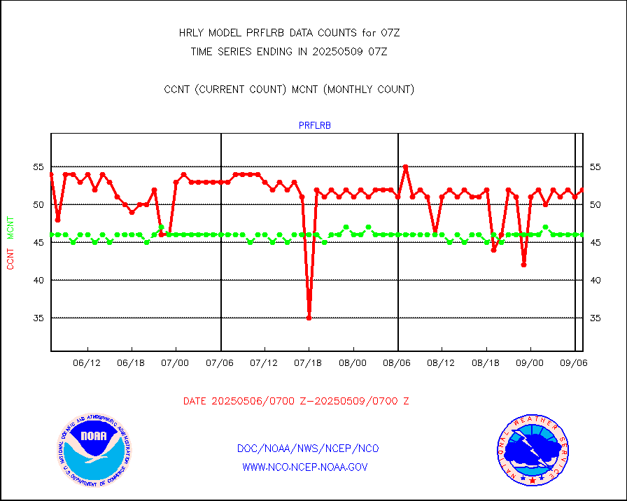
prflrb |
Multi-Agency Profiler (MAP) and SODAR winds |
35 |
42 |
83.3 % |
1906.50-1907.49 |
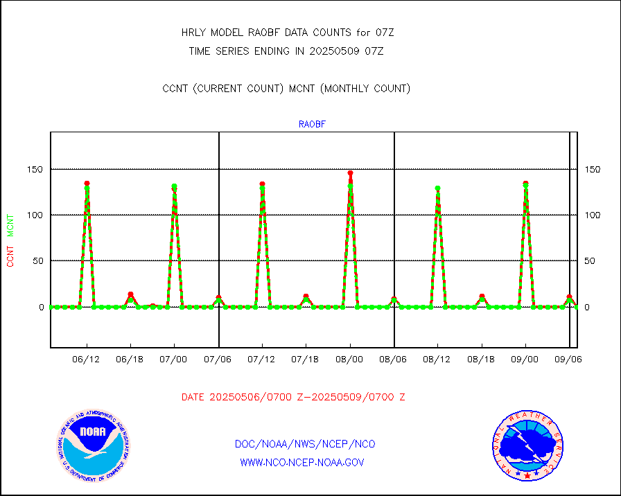
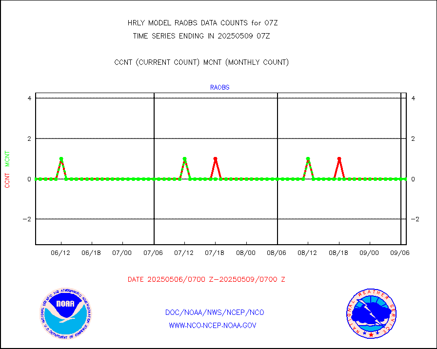
raobf |
Rawinsonde - fixed land (from TEMP or PILOT) |
0 |
0 |
n/a |
1906.50-1907.49 |
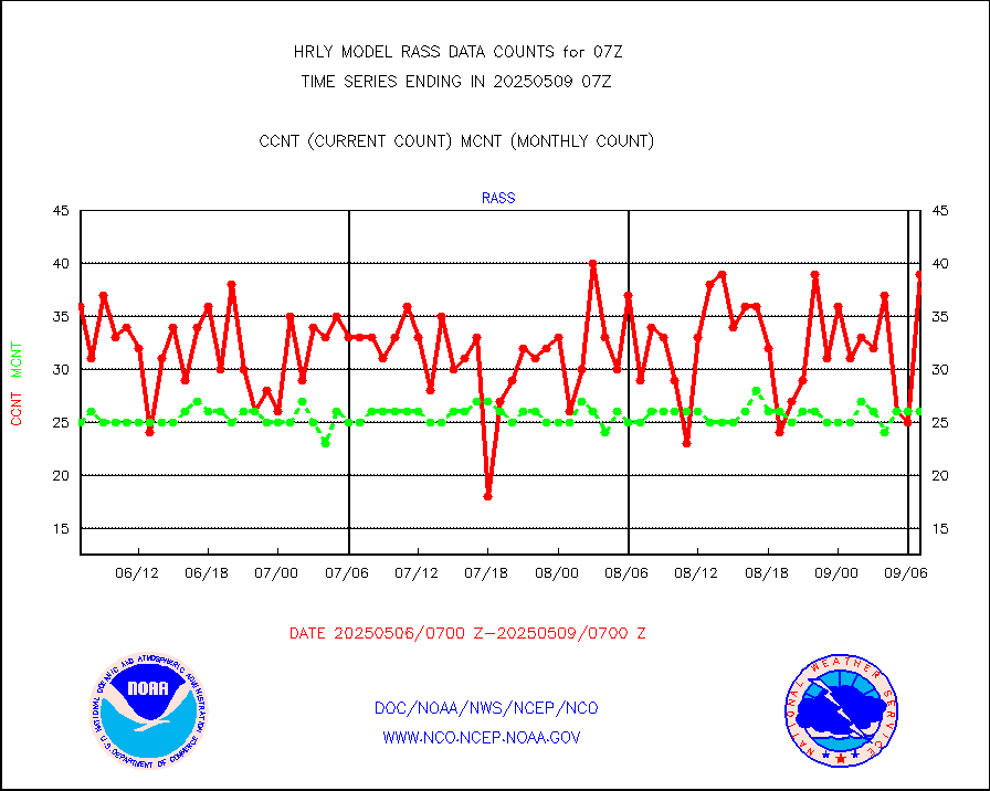
rass |
RASS temperatures (NOAA and Multi-Agency) |
16 |
26 |
61.5 % |
1906.50-1907.49 |
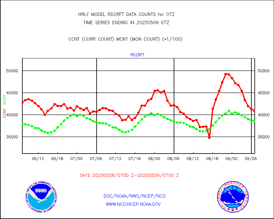
rd2rft |
NEXRAD reflectivity (Lvl 2 - GTS) |
4085271 |
3928243 |
104.0 % |
1906.50-1907.49 |
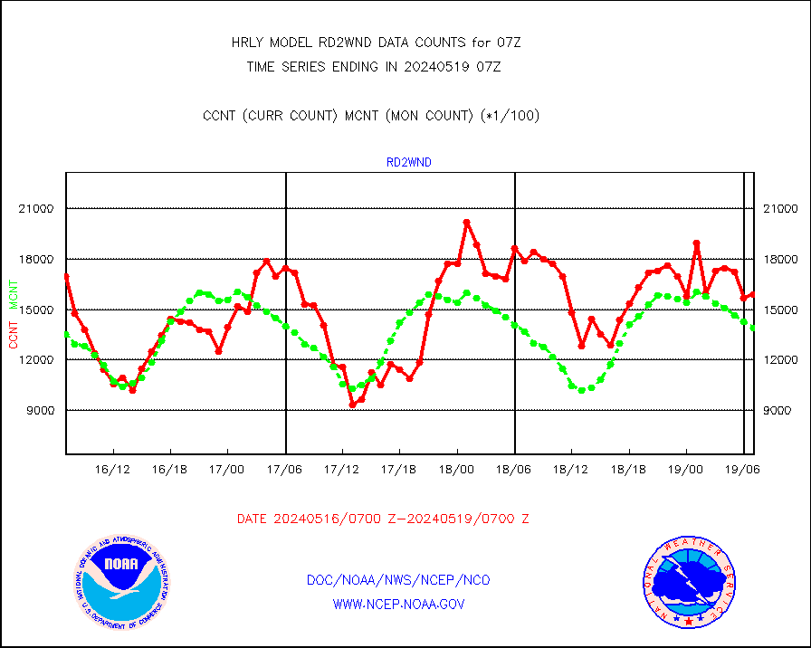
rd2wnd |
NEXRAD radial wind (Level 2 - GTS) |
1590571 |
1390707 |
114.4 % |
1906.50-1907.49 |
sevcsr |
METEOSAT-10 2nd Gen SEVIRI Clr Sky Radiance(proc) |
0 |
0 |
n/a |
1906.50-1907.49 |
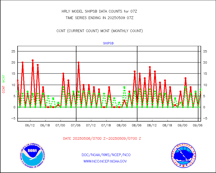
shipsb |
Ship - manual and automatic, restricted (BUFR) |
1 |
0 |
n/a |
1906.50-1907.50 |
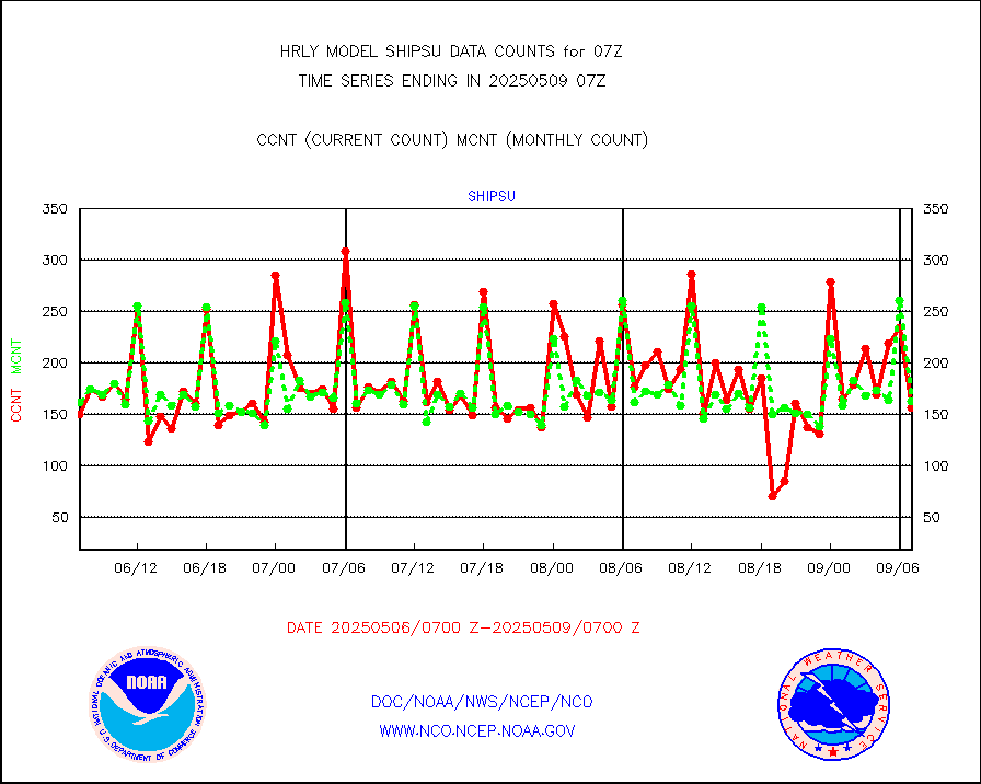
shipsu |
Ship - manual and automatic, unrestricted |
126 |
117 |
107.7 % |
1906.50-1907.50 |
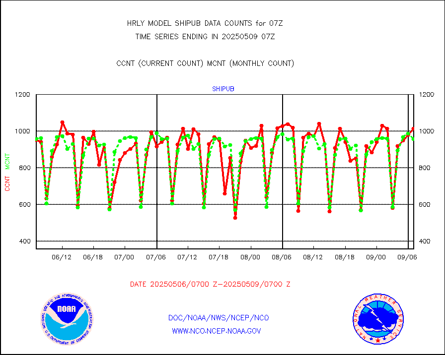
shipub |
Ship - manual and automatic, unrestricted (BUFR) |
807 |
842 |
95.8 % |
1906.50-1907.50 |
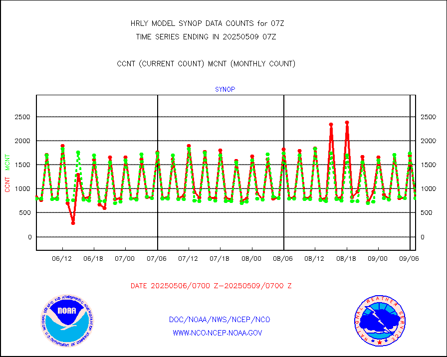
synop |
Synoptic - fixed manual and automatic |
955 |
889 |
107.4 % |
1906.50-1907.49 |
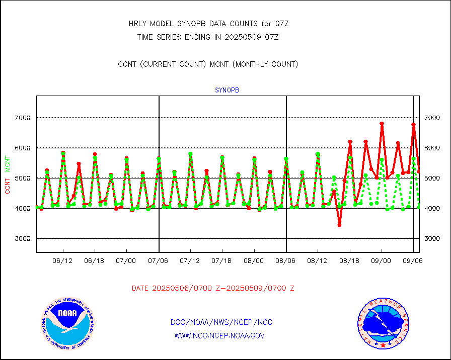
synopb |
Synoptic - fixed manual & auto (decoded fr BUFR) |
4088 |
4105 |
99.6 % |
1906.50-1907.49 |
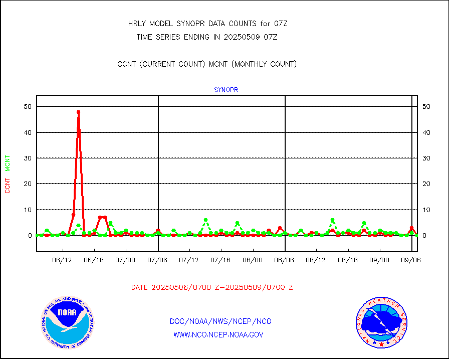
synopr |
Synoptic - restricted (WMO Res 40) manual & auto. |
0 |
0 |
n/a |
1906.50-1907.49 |
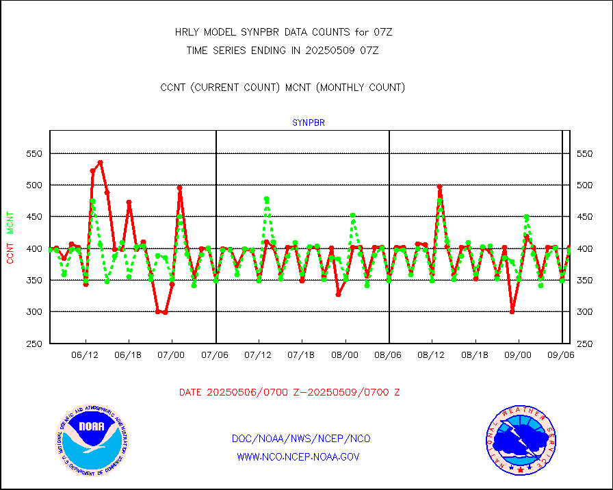
synpbr |
Synoptic - restricted (WMO Res 40)(decoded BUFR) |
397 |
396 |
100.3 % |
1906.50-1907.49 |
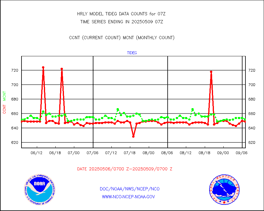
tideg |
Tide gauge reports decoded from CREX format |
647 |
642 |
100.8 % |
1906.00-1906.99 |
| Data Types of Opportunity with Normal Counts |
|---|
| Type | Description | Hourly Count | Monthly Average | Percent (%) of Monthly Mean | UTC Time Window |
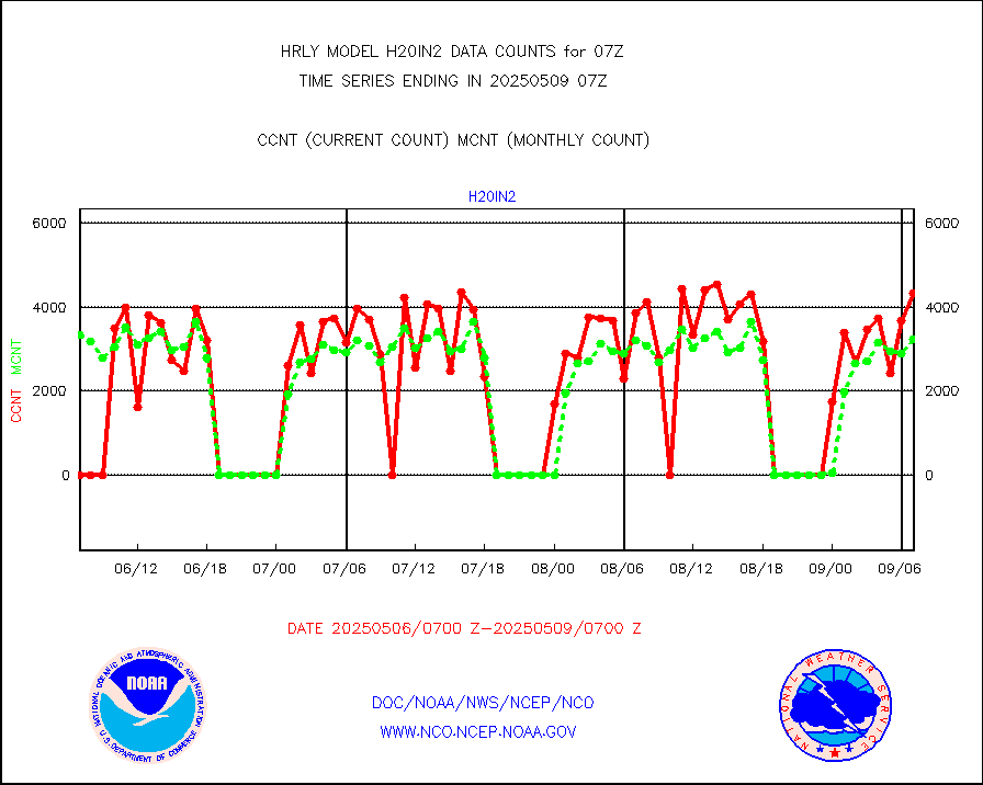
3p9usr |
GOES-16&up/NESDIS ir short-wv derived cld motion |
44474 |
44051 |
101.0 % |
1906.00-1906.99 |
acarsa |
MDCRS ACARS acft data (ARINC via AFWA)(AIREP fmt) |
0 |
0 |
n/a |
1906.50-1907.49 |
ahicsr |
Himawari Clear Sky Radiance |
0 |
0 |
n/a |
1906.00-1906.99 |
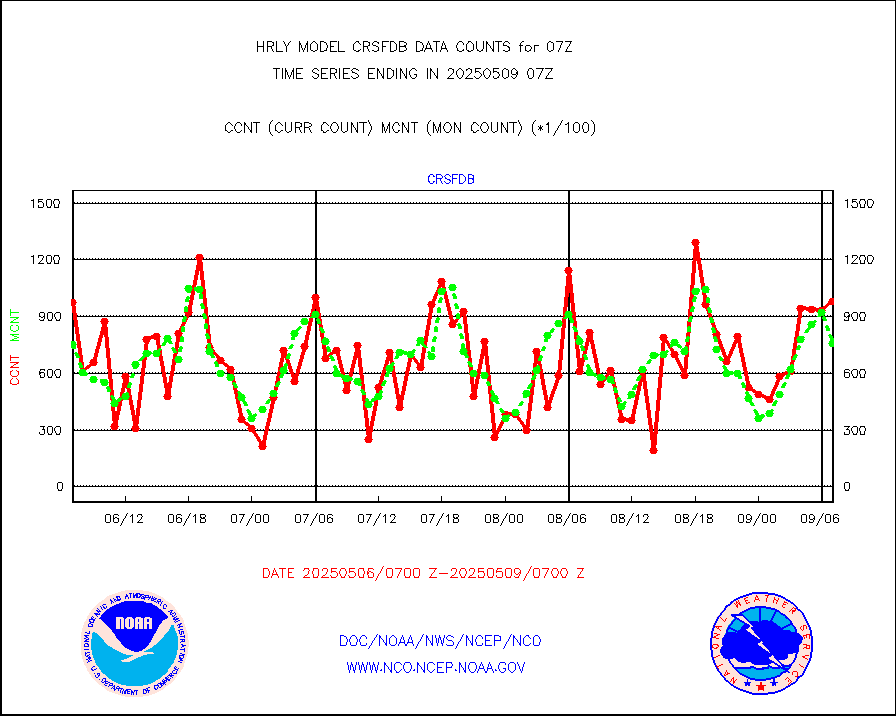
amsr2 |
GCOM-W AMSR2 1B brightness temperatures |
1791396 |
2188005 |
81.9 % |
1905.00-1905.99 |
atmsdb |
NPP/NOAA-20 ATMS bright. temps-direct b-cast SSEC |
99505 |
85480 |
116.4 % |
1905.50-1906.49 |
atovs |
POES/NESDIS - processed ATOVS soundings/radiances |
0 |
0 |
n/a |
1905.00-1905.99 |
avcsam |
A.M.(N17,M2,M3) AVHRR GAC NCEP-proc clr&sea btmps |
1171480 |
1299898 |
90.1 % |
1904.50-1905.49 |
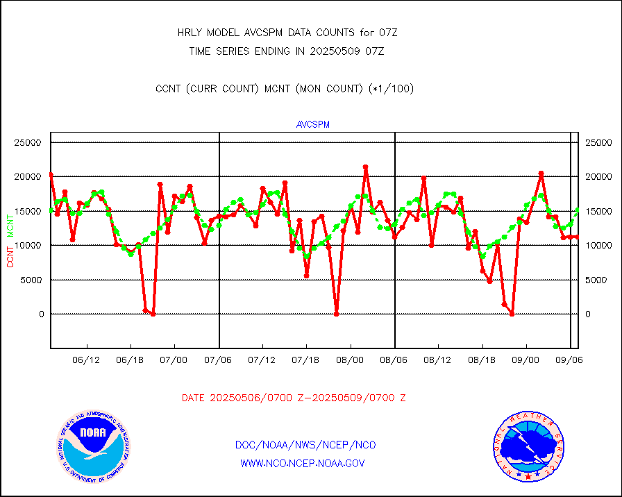
avcspm |
P.M.(N18-19) AVHRR GAC NCEP-proc clr & sea btemps |
427813 |
1421400 |
30.1 % |
1904.50-1905.49 |
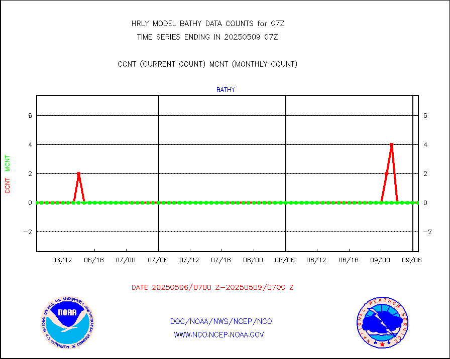
bathy |
eXpendable BathyThermograph, mooring (BATHY fmt) |
0 |
0 |
n/a |
1900.00-1900.99 |
coopmd |
Coop/MADIS NEPP & HCN-Modernization NOAA COOP Obs |
27 |
27 |
100.0 % |
1906.50-1907.49 |
crisf4 |
NPP/NOAA-20 CrIS full spctrl radn (431 ch subset) |
229734 |
235125 |
97.7 % |
1905.50-1906.49 |
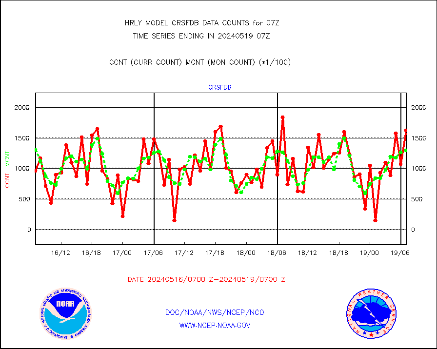
crsfdb |
NPP/NOAA-20 CrIS full spctrl radn dir brdcst SSEC |
162576 |
129887 |
125.2 % |
1905.50-1906.49 |
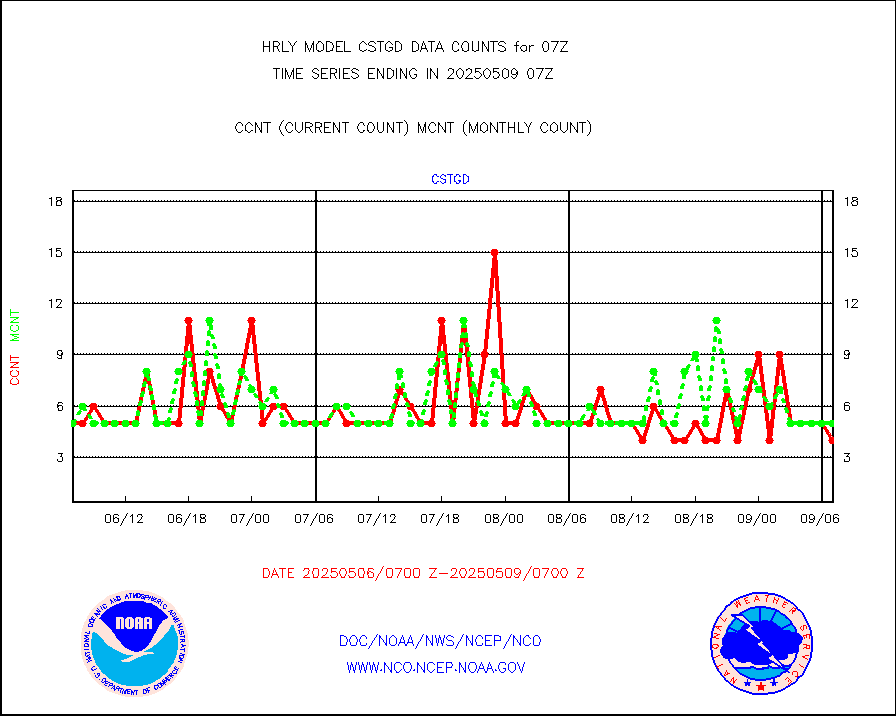
cstgd |
Coast Guard |
3 |
3 |
100.0 % |
1906.50-1907.50 |
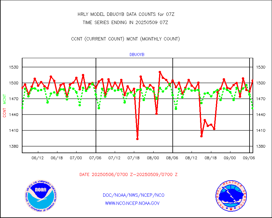
dbuoyb |
Drifting buoys (decoded from BUFR) |
1405 |
1398 |
100.5 % |
1906.50-1907.50 |
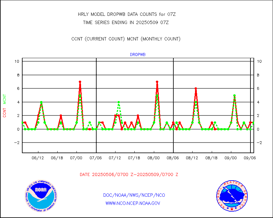
dropw |
Dropwinsonde (from TEMP DROP) |
0 |
0 |
n/a |
1906.50-1907.49 |
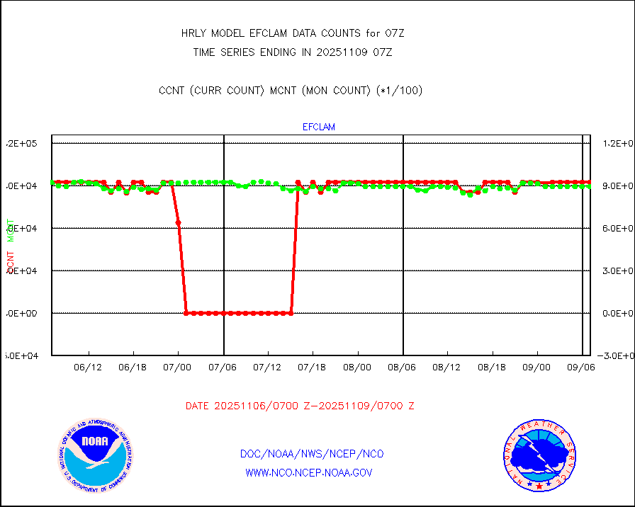
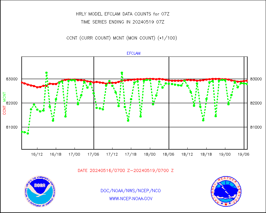
efclam |
GOES imager effective cloud amount data (U.Wisc.) |
8292932 |
8279050 |
100.2 % |
1906.50-1907.49 |
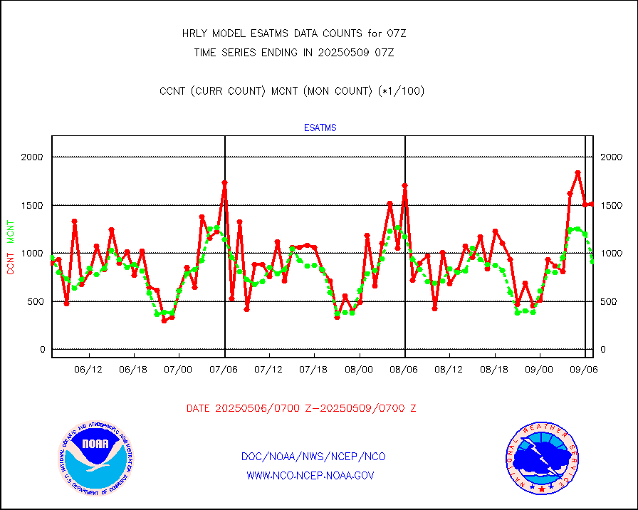
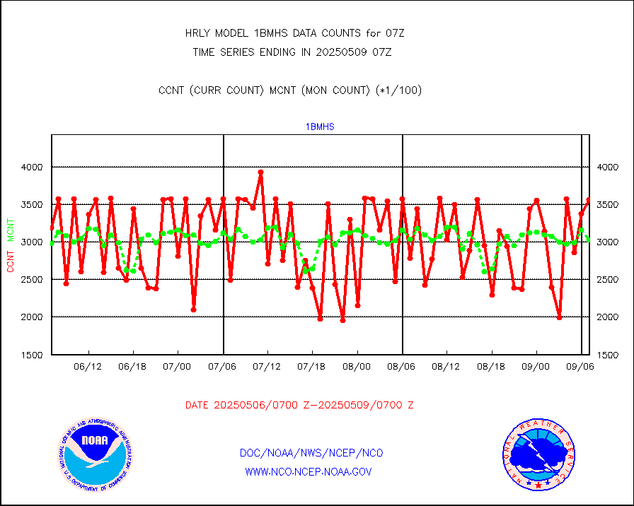
esatms |
NPP Adv. Tech. MW Sndr (ATMS) br. temps from RARS |
97536 |
105268 |
92.7 % |
1905.50-1906.49 |
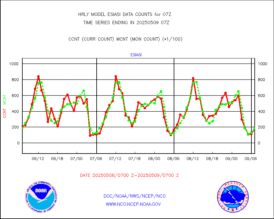
esiasi |
METOP 1-2 IASI 1C radiance data vbl chn from RARS |
46051 |
31501 |
146.2 % |
1906.00-1906.99 |
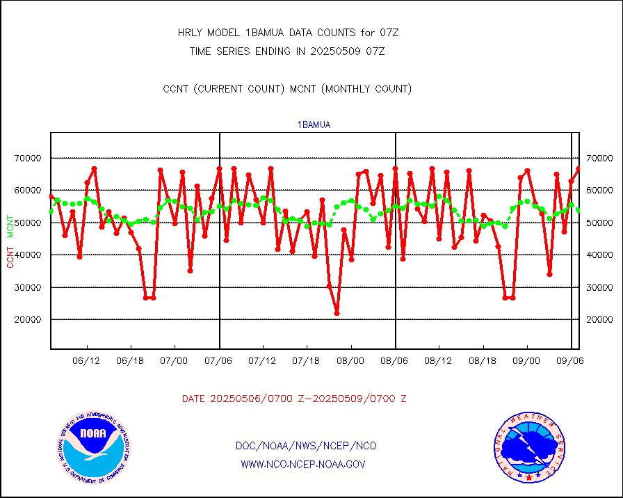
esmhs |
NOAA 18-19 & METOP 1-2 MHS proc. btemps from RARS |
198544 |
100012 |
198.5 % |
1906.50-1907.49 |
geoimr |
GOES/NESDIS (11x17 f-o-v) imager clear radiances |
0 |
0 |
n/a |
1906.00-1906.99 |
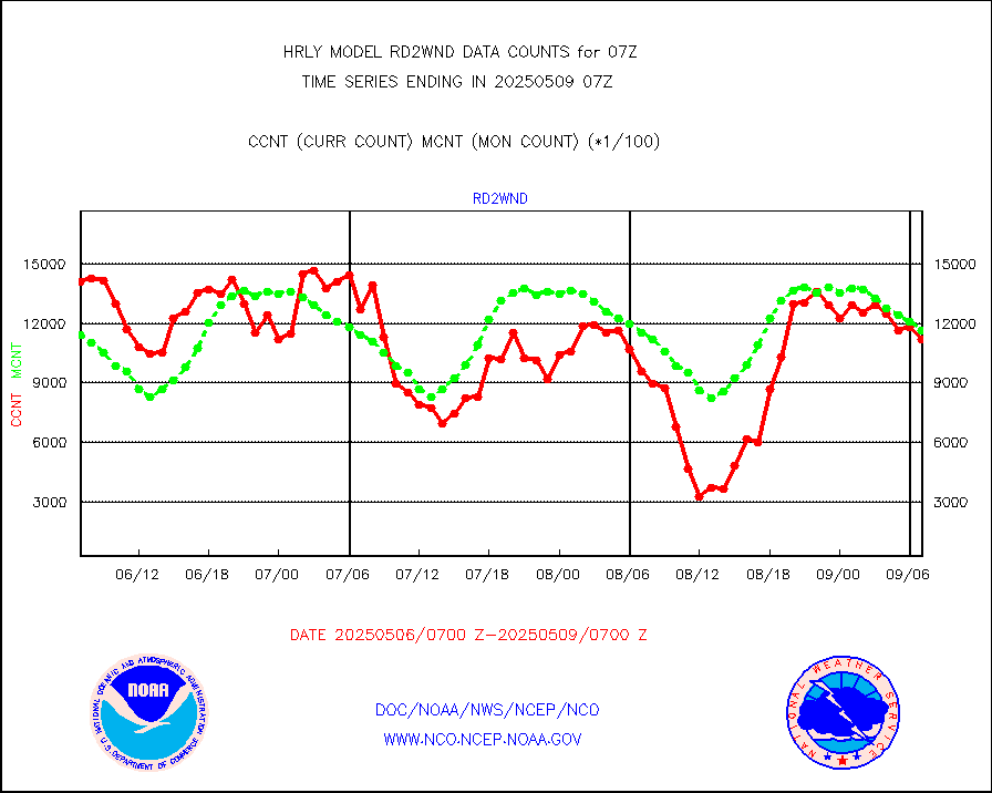
gome |
METOP 1-2 Global Ozone Monitoring Exp.-2 (GOME-2) |
4496 |
7170 |
62.7 % |
1905.50-1906.49 |
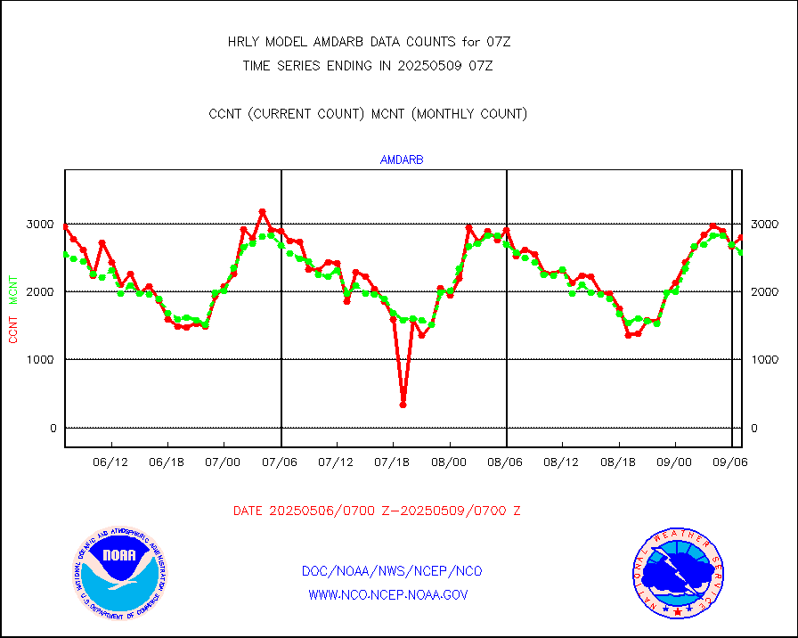
h20in2 |
INDIA SATWIND, INSAT WV channel |
4238 |
5797 |
73.1 % |
1906.00-1906.99 |
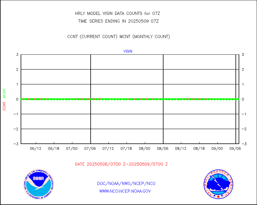
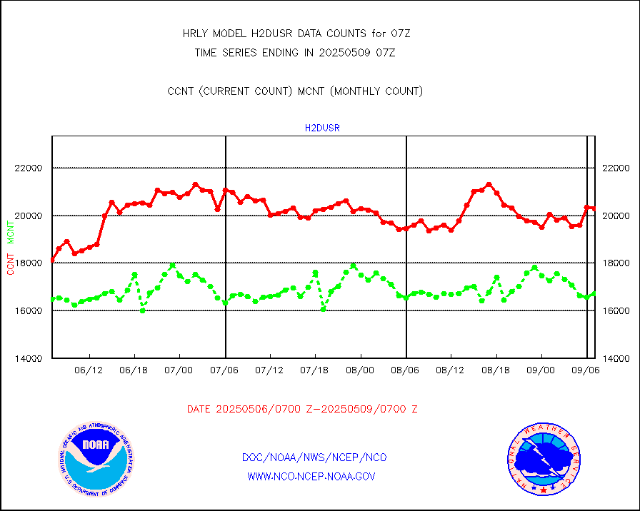
h2dusr |
GOES-16&up/NESDIS wv imgr/deep-lyr derivd cld mtn |
14992 |
15830 |
94.7 % |
1906.00-1906.99 |
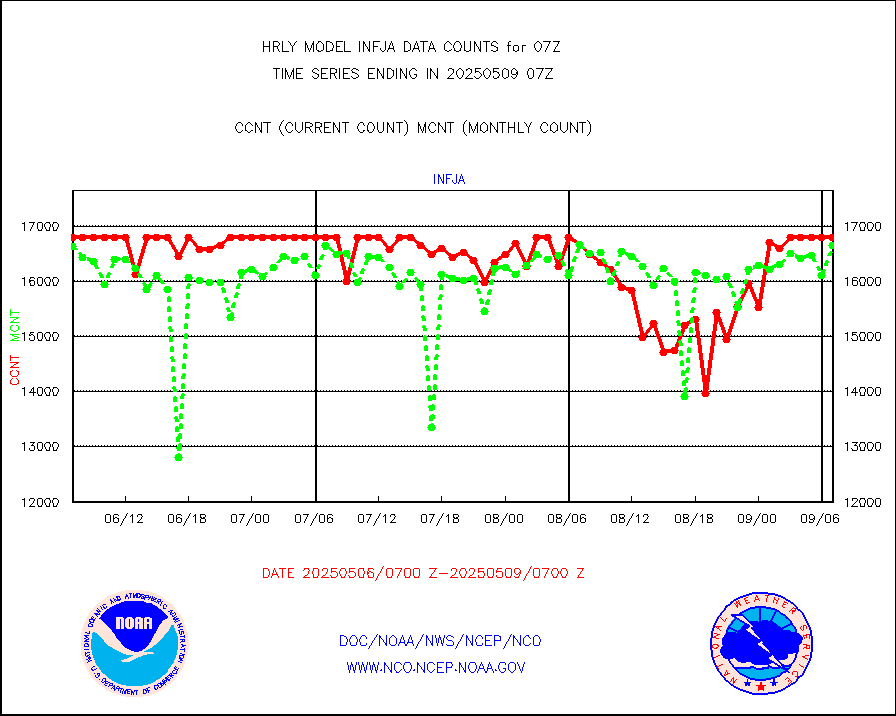
h2eunb |
METEOSAT/EUMETSAT wvpr imgr drv cld motion NBseq |
38485 |
40446 |
95.2 % |
1905.50-1906.49 |
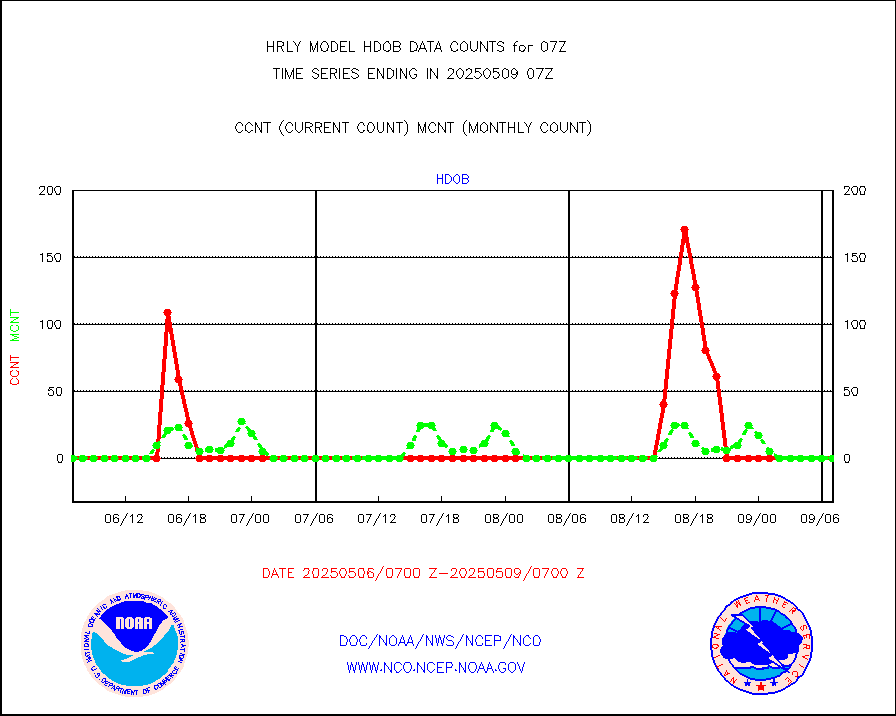
hdob |
High Density OBs from reconnaissance acft data |
0 |
4 |
0.0 % |
1906.50-1907.49 |
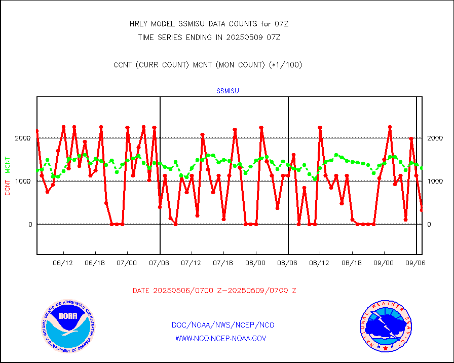
iasidb |
METOP 1-2 IASI 1C radiances-direct broadcast SSEC |
19577 |
25973 |
75.4 % |
1905.50-1906.49 |
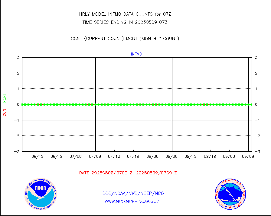
ifvrnb |
VIIRS (NPP/NOAA-20) ir lg-wv drv cloud motion(NB) |
20863 |
20543 |
101.6 % |
1903.00-1903.99 |
infav |
AVHRR (NOAA/METOP) ir lg-wave derived cld motion |
0 |
0 |
n/a |
1903.00-1903.99 |
infav1 |
AVHRR (METOP) ir lg-wave derived cld motion |
0 |
0 |
n/a |
1906.50-1907.50 |
infin |
INSAT/KALPANA India ir lg-wave derived cld motion |
0 |
0 |
n/a |
1904.50-1905.49 |
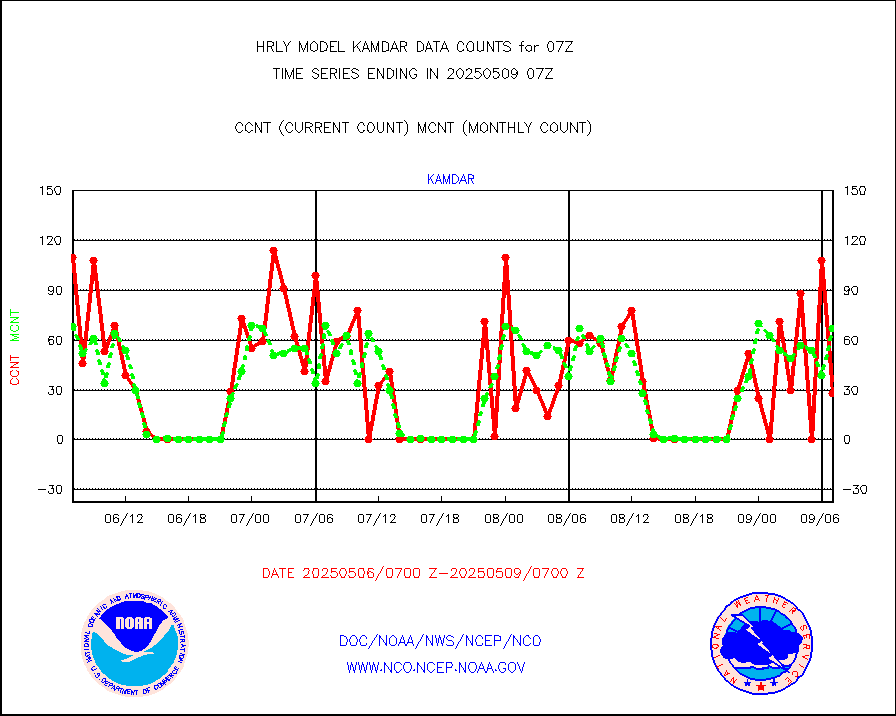
infin2 |
INDIA SATWIND, INSAT IR channel |
6727 |
6068 |
110.9 % |
1906.00-1906.99 |
kamdar |
Korean AMDAR aircraft data (decoded from BUFR) |
28 |
62 |
45.2 % |
1906.50-1907.49 |
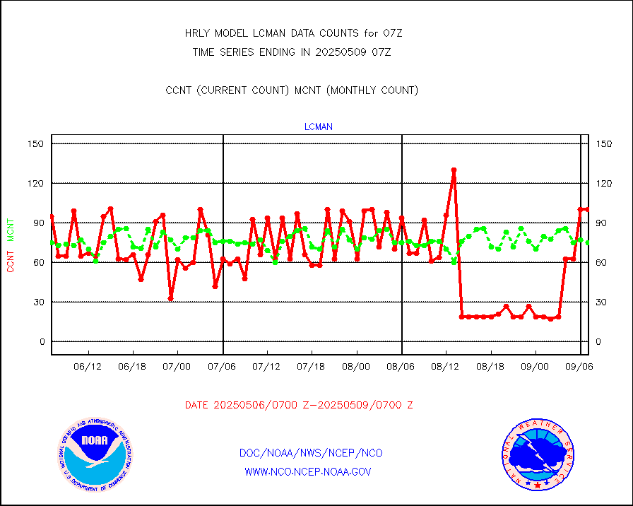
lcman |
Land-based CMAN stations decoded from CMAN format |
93 |
78 |
119.2 % |
1906.50-1907.49 |
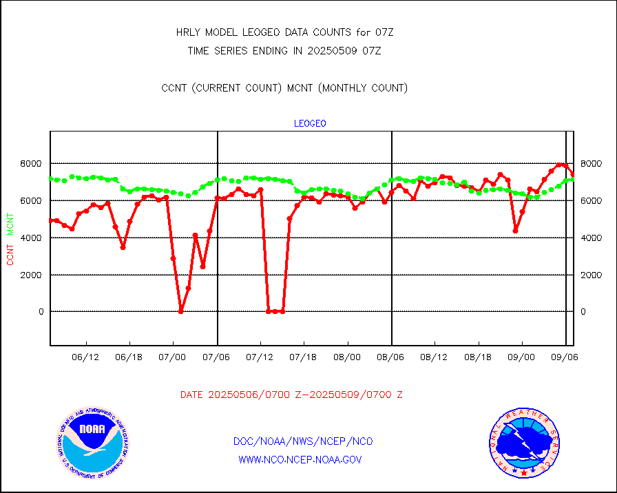
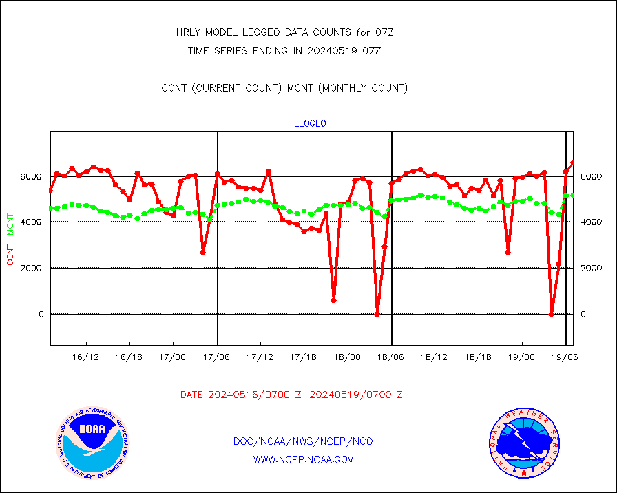
leogeo |
LEO-GEO satellite AMVs from UWisc. |
6593 |
5181 |
127.3 % |
1903.00-1903.99 |
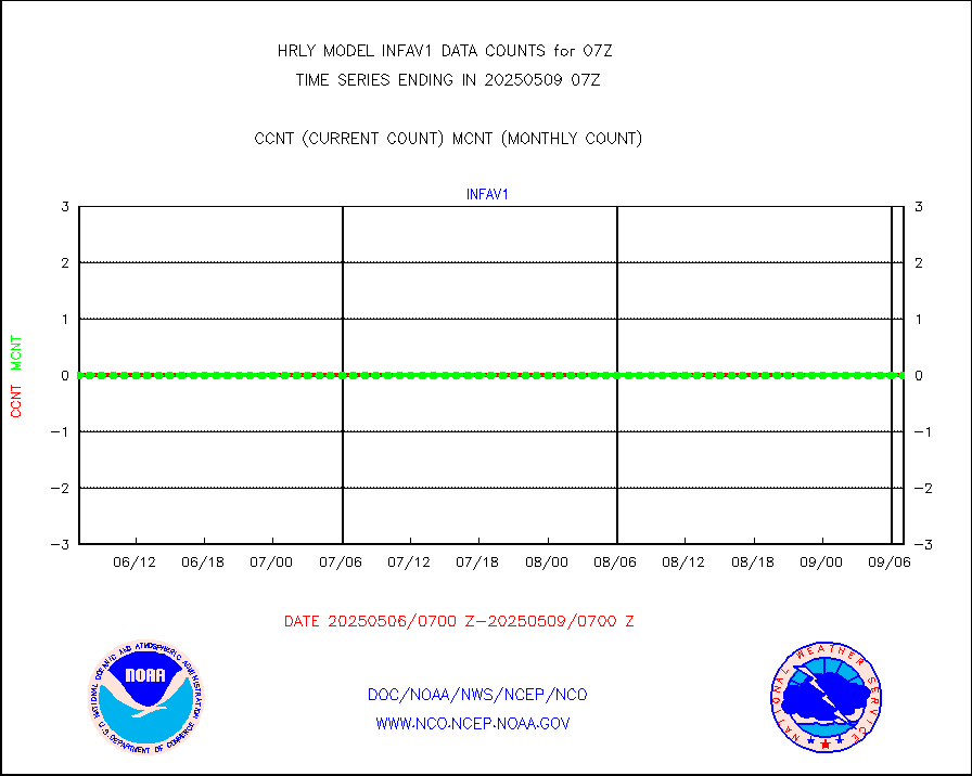
ltnglr |
LLDN Long-rng lightning from Vaisala via NOAAPORT |
153858 |
129483 |
118.8 % |
1906.50-1907.49 |
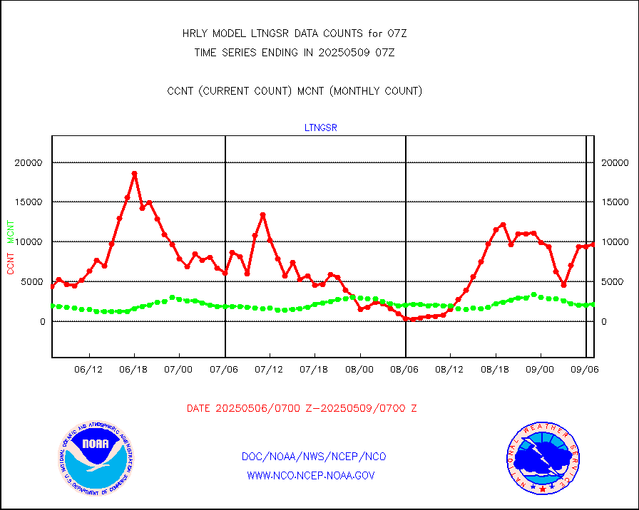
ltngsr |
NLDN Shrt-rng lightning from Vaisala via NOAAPORT |
2742 |
3131 |
87.6 % |
1906.50-1907.49 |
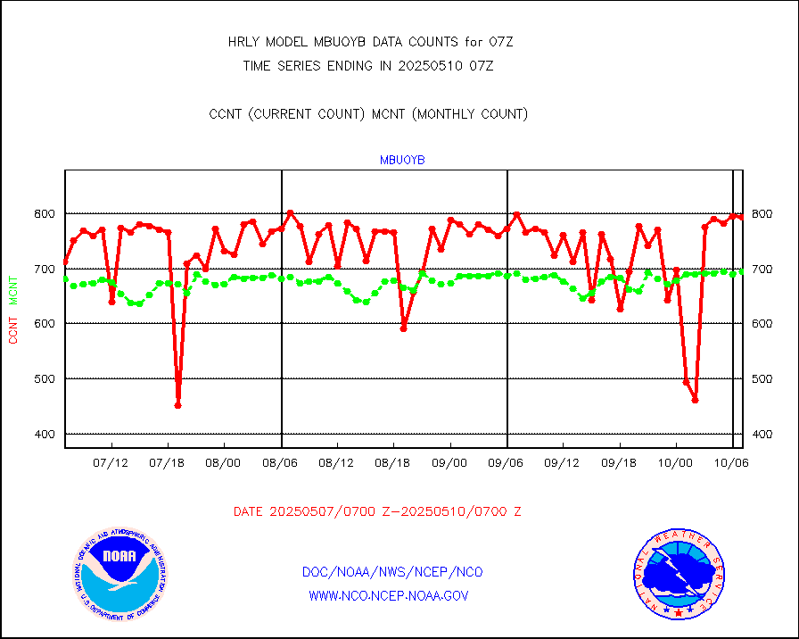
mbuoyb |
Moored buoys (decoded from BUFR) |
832 |
758 |
109.8 % |
1906.50-1907.50 |
mls |
Aura Microwave Limb Sounder (MLS) ozone data |
0 |
0 |
n/a |
1905.00-1905.99 |
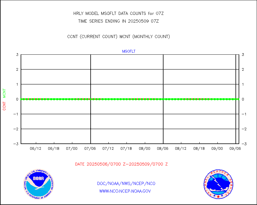
msourb |
Mesonet/MADIS UrbaNet |
4355 |
4366 |
99.7 % |
1906.50-1907.49 |
nxrdw2 |
NEXRAD Vel Azm Dsp(VAD) winds via Level 2 decoder |
708 |
607 |
116.6 % |
1906.50-1907.49 |
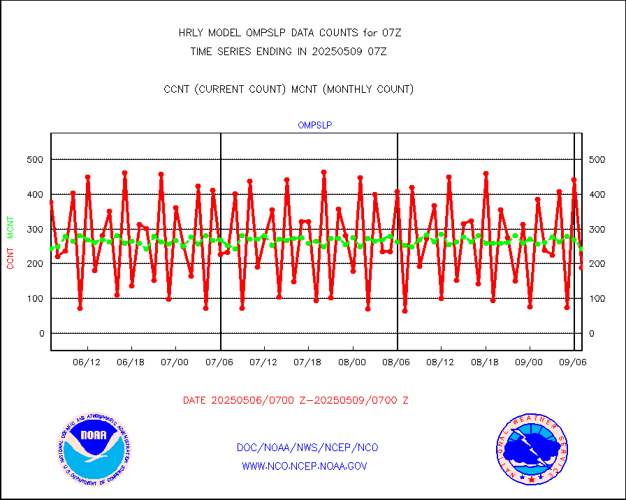
ompslp |
OMPS Limb Profiler ozone data (NPP) |
399 |
224 |
178.1 % |
1900.00-1900.99 |
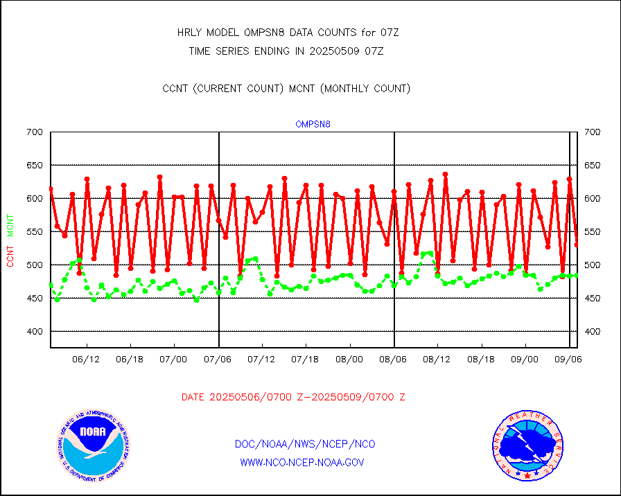
ompsn8 |
OMPS nadir profile ozone (Version 8 BUFR) |
589 |
559 |
105.4 % |
1905.00-1905.99 |
ompst8 |
OMPS total column ozone (Version 8 BUFR) |
249415 |
350497 |
71.2 % |
1905.00-1905.99 |
pirep |
Manual PIREP aircraft data (dcded from AIREP fmt) |
7 |
11 |
63.6 % |
1906.50-1907.49 |
prflrp |
Profilr winds from PIBAL (PILOT,PILOT SHIP/MOBIL) |
0 |
0 |
n/a |
1906.50-1907.49 |
raobm |
Rawinsonde - mobile land (from TEMP/PILOT MOBIL) |
0 |
0 |
n/a |
1906.50-1907.49 |
raobs |
Rawinsonde - ship (from TEMP SHIP, PILOT SHIP) |
0 |
0 |
n/a |
1906.50-1907.49 |
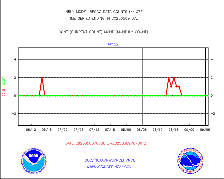
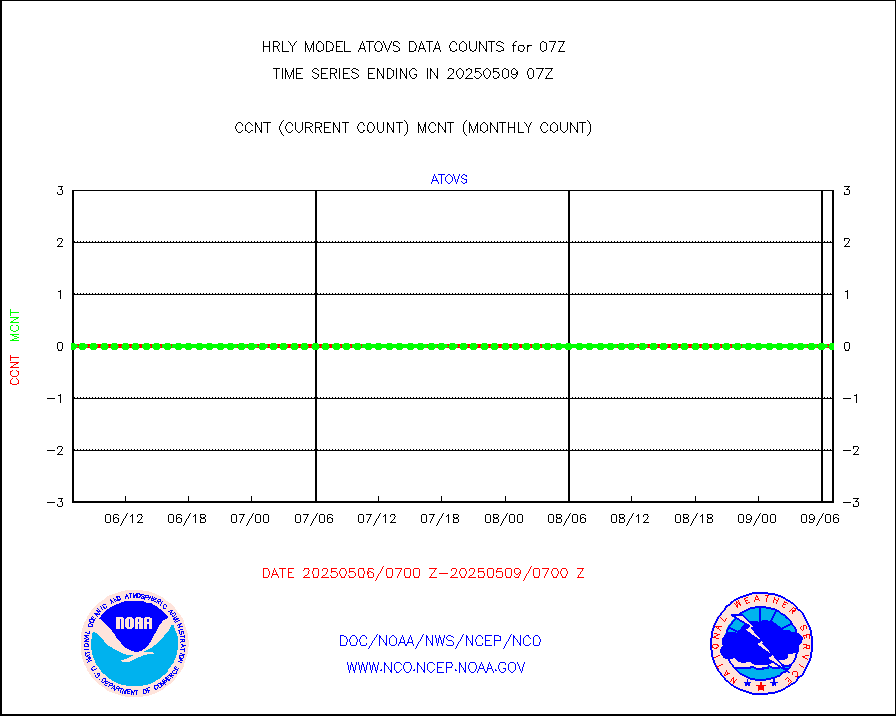
recco |
Flight level reconnaissance aircraft data |
0 |
0 |
n/a |
1906.50-1907.49 |
saphir |
Megha-Tropiques SAPHIR L1A2 brightness temps |
0 |
0 |
n/a |
1904.50-1905.49 |
sevasr |
METEOSAT-10 2nd Gen SEVIRI All Sky Radiance(proc) |
75512 |
72934 |
103.5 % |
1906.50-1907.49 |
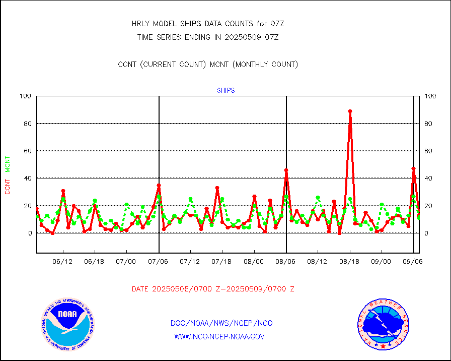
ships |
Ship - manual and automatic, restricted |
8 |
4 |
200.0 % |
1906.50-1907.49 |
ssmisu |
DMSP SSM/IS 1C radiance data (Unified Pre-Proc.) |
172680 |
117442 |
147.0 % |
1905.50-1906.49 |
sstvcw |
NPP/NOAA-20 VIIRS SST - CLEAR & OVER WATER |
0 |
344131 |
0.0 % |
1906.50-1907.49 |
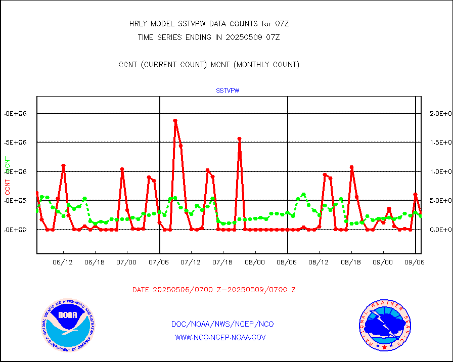
sstvpw |
NPP/NOAA-20 VIIRS SST - PROBABLY CLR & OVER WATER |
0 |
123975 |
0.0 % |
1906.50-1907.49 |
synopm |
Synoptic - mobile manual and automatic |
623 |
559 |
111.4 % |
1906.50-1907.49 |
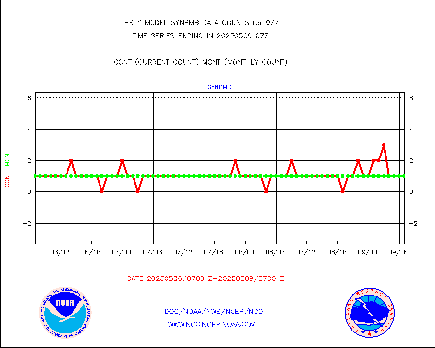
synpmb |
Synoptic - mobile manual & auto (decoded fr BUFR) |
0 |
1 |
0.0 % |
1906.50-1907.49 |
tesac |
CTD probe, Argo prflng float, mooring (TESAC fmt) |
194 |
192 |
101.0 % |
1906.50-1907.49 |
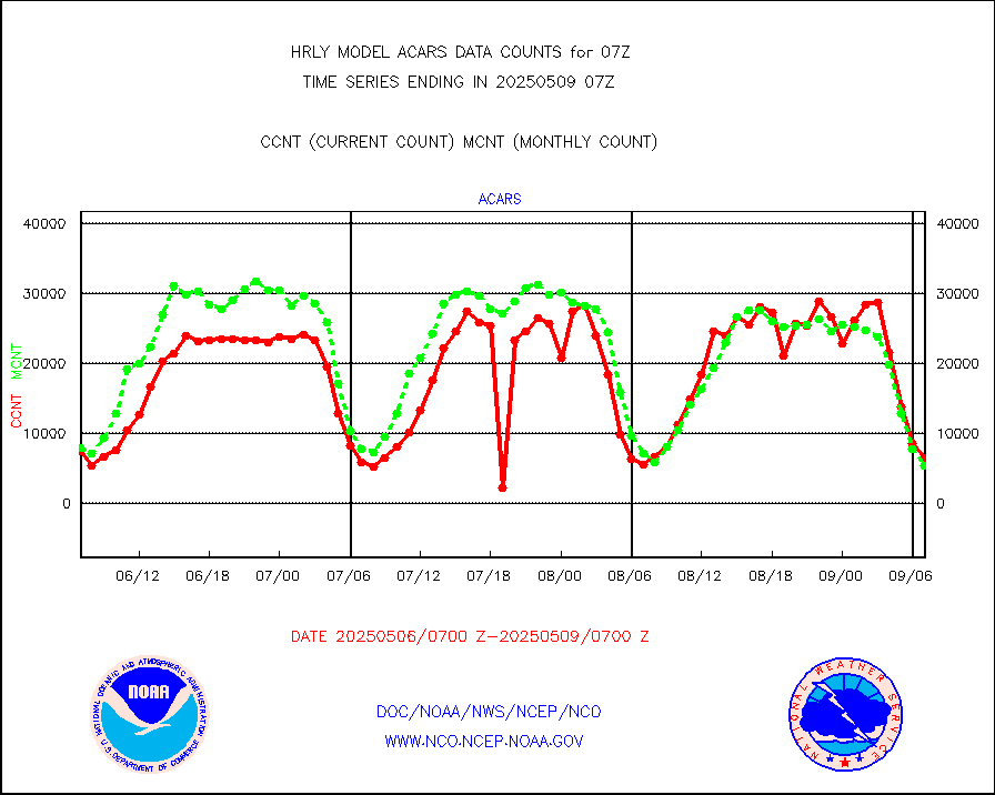
tmdara |
TAMDAR aircft data-all types(from Panasonic,BUFR) |
267 |
353 |
75.6 % |
1906.50-1907.49 |
trkob |
ThermoSalinoGraph (TSG) TRACKOB format) |
90 |
43 |
209.3 % |
1905.50-1906.49 |
visin |
INSAT/KALPANA India visible derived cloud motion |
0 |
0 |
n/a |
1904.50-1905.49 |
visin2 |
INDIA SATWIND, INSAT VIS channel |
951 |
664 |
143.2 % |
1906.00-1906.99 |
visja |
MTSAT/JMA visible derived cloud motion |
8450 |
10657 |
79.3 % |
1904.50-1905.49 |
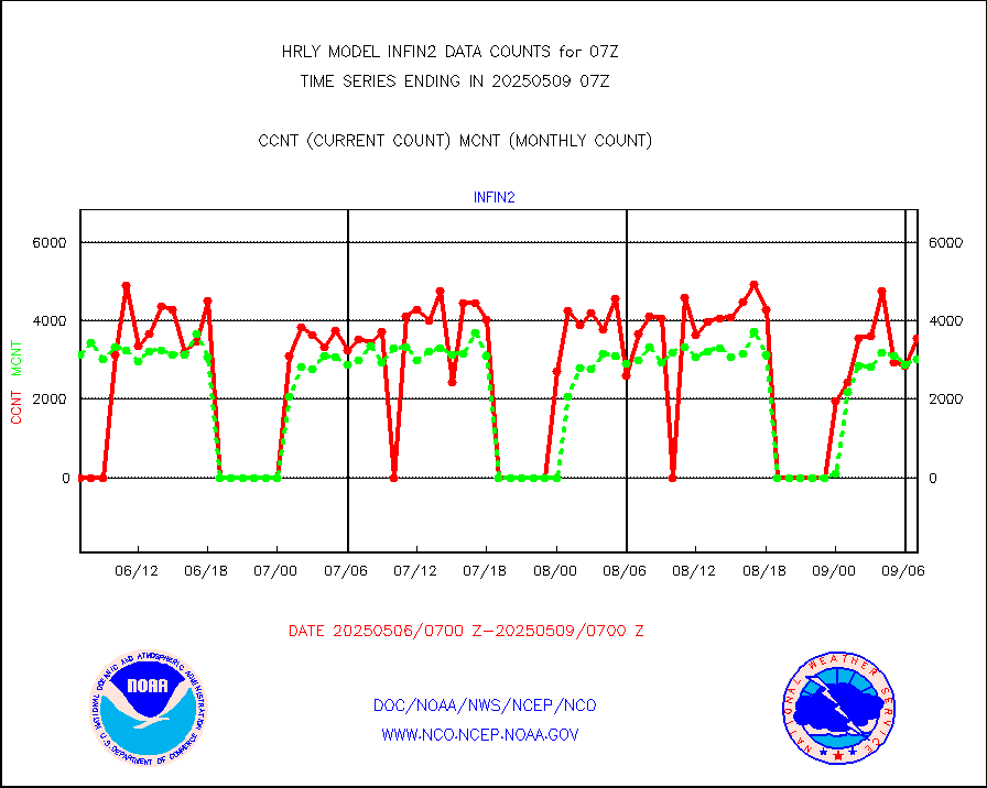
visusr |
GOES-16&up/NESDIS visible derived cloud motion |
4854 |
3052 |
159.0 % |
1906.00-1906.99 |
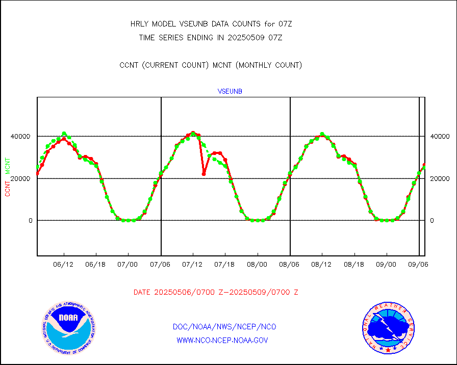
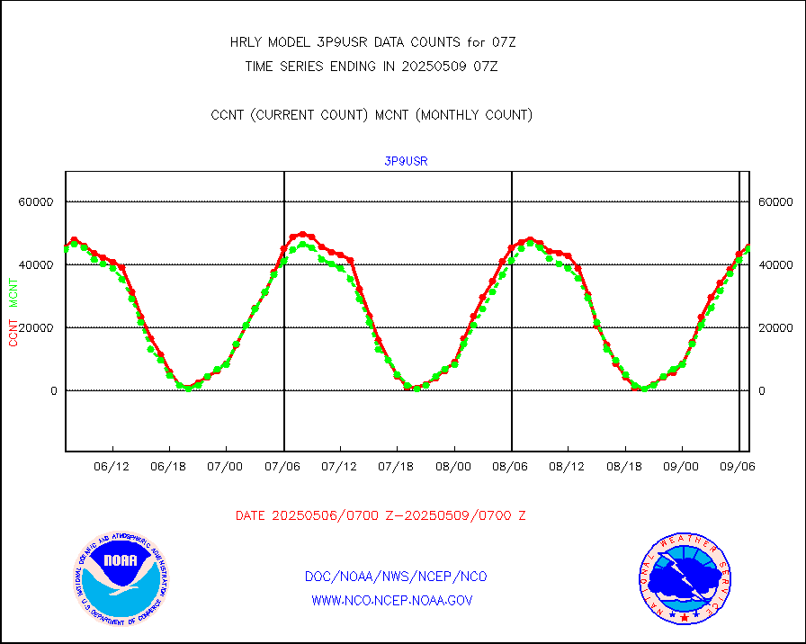
vseunb |
METEOSAT/EUMETSAT visible drv cld motion NBseq |
26764 |
23660 |
113.1 % |
1905.50-1906.49 |


