| Critical Data with Normal Counts |
|---|
| Type | Description | Hourly Count | Monthly Average | Percent (%) of Monthly Mean | UTC Time Window |
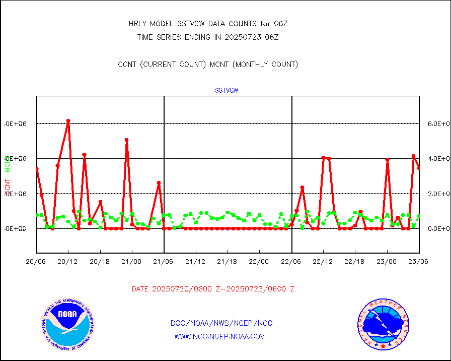
1bamua |
NOAA 15-19 & METOP 1-2 AMSU-A NCEP-proc. br.temps |
48517 |
54760 |
88.6 % |
2004.00-2004.99 |
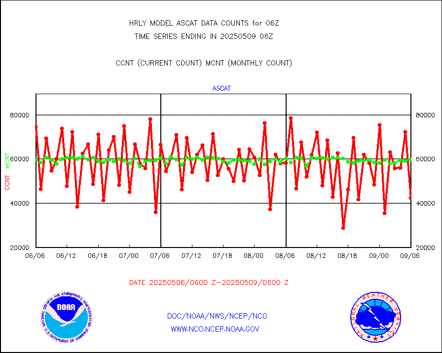
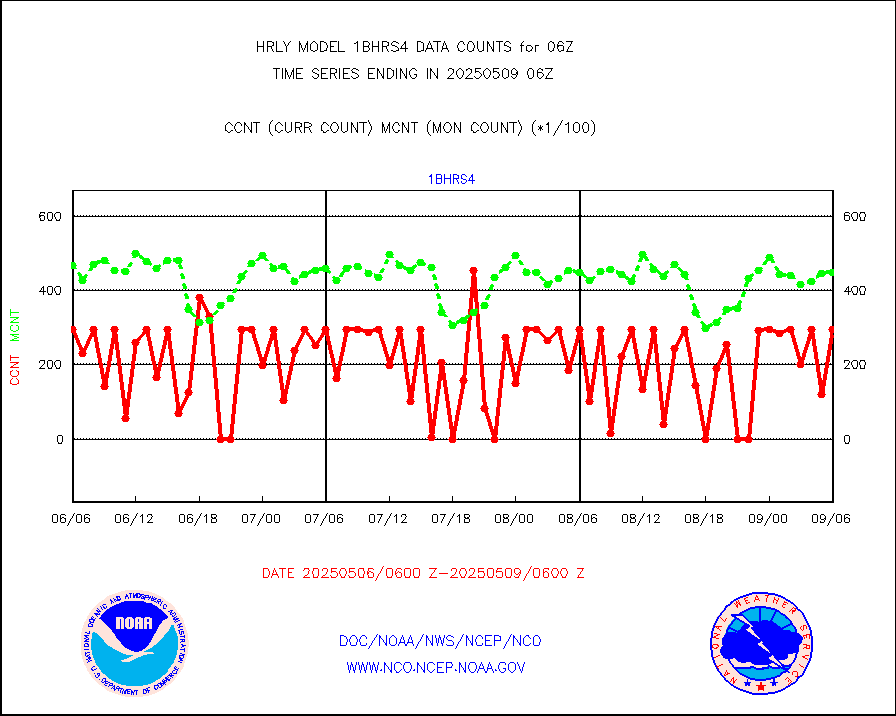
1bhrs4 |
NOAA 18-19 & METOP 1-2 HIRS-4 NCEP-proc. br.temps |
43420 |
49946 |
86.9 % |
2004.00-2004.99 |
1bmhs |
NOAA 18-19 & METOP 1-2 MHS NCEP-proces. br. temps |
353375 |
303251 |
116.5 % |
2004.00-2004.99 |
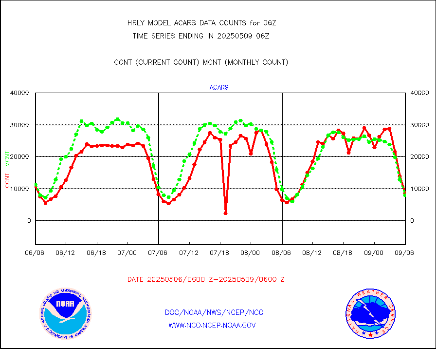
acars |
MDCRS ACARS acft data from ARINC(dcded from BUFR) |
7159 |
2496 |
286.8 % |
2005.50-2006.49 |
airep |
Manual AIREP aircraft data (dcded from AIREP fmt) |
1426 |
1214 |
117.5 % |
2005.50-2006.49 |
airsev |
AQUA AIRS/AMSU-A/HSB brightness temps- every FOV |
0 |
0 |
n/a |
2003.50-2004.49 |
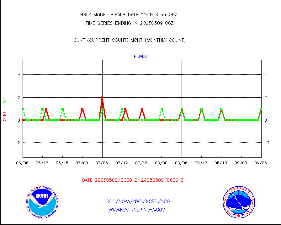
amdar |
AMDAR aircraft data (decoded from AMDAR format) |
383 |
314 |
122.0 % |
2005.50-2006.49 |
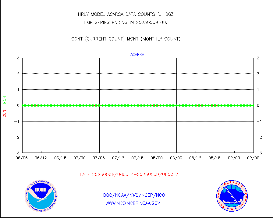
amdarb |
AMDAR aircraft data (decoded from BUFR) |
1129 |
1305 |
86.5 % |
2005.50-2006.49 |
ascat |
METOP 1-2 ASCAT products |
54264 |
44344 |
122.4 % |
2004.50-2005.49 |
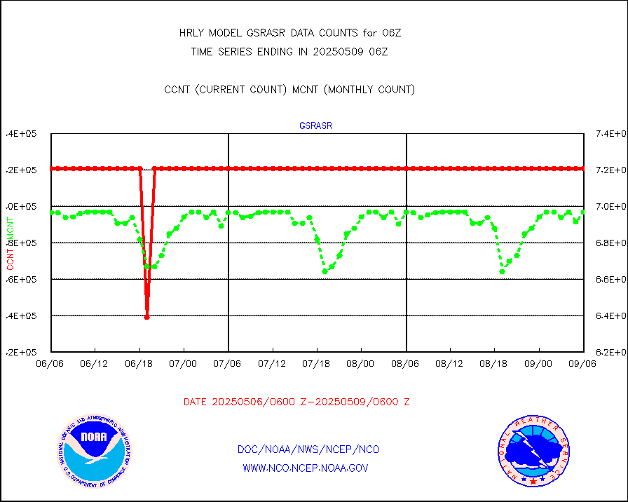
atms |
NPP/NOAA-20 ATMS brightness temperatures |
341760 |
349808 |
97.7 % |
2004.50-2005.49 |
camdar |
Canadian AMDAR aircraft data (decoded from BUFR) |
0 |
0 |
n/a |
2005.50-2006.49 |
cmanb |
Surface Marine CMAN rpts decoded from BUFR format |
1839 |
1832 |
100.4 % |
2005.50-2006.50 |
dbuoy |
Buoys decoded from FM-18 fmt (moored or drifting) |
39 |
35 |
111.4 % |
2005.50-2006.49 |
eadas |
E-AMDAR (European AMDAR acft decoded from BUFR) |
1489 |
1451 |
102.6 % |
2005.50-2006.49 |
esamua |
NOAA 15-19 & METOP 1-2 AMSU-A proc btmps frm RARS |
18258 |
18289 |
99.8 % |
2005.50-2006.49 |
eshrs3 |
NOAA 15-19 & METOP 1-2 HIRS-3/4 pr btmps frm RARS |
40151 |
39349 |
102.0 % |
2005.50-2006.49 |
gnss |
Grnd-based Gbl Navigation Sat System (GNSS) data |
9421 |
9036 |
104.3 % |
2005.00-2005.99 |
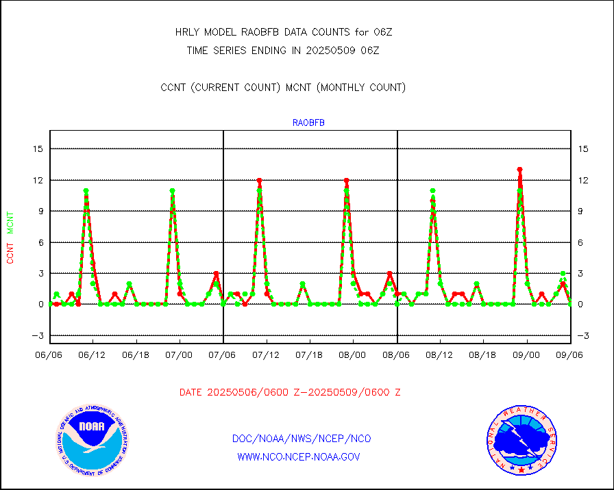
gpsro |
GPS radio occultation data |
460 |
464 |
99.1 % |
2003.50-2004.49 |
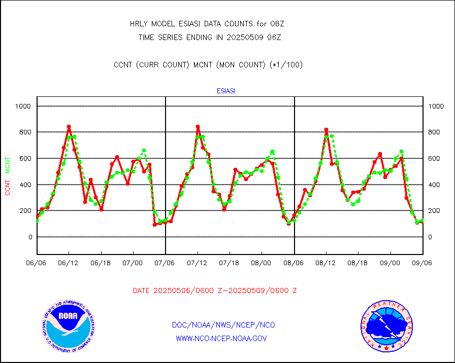
gsrasr |
GOES-16/17 All Sky Radiances (proc.) |
360476 |
354468 |
101.7 % |
2005.50-2006.49 |
gsrcsr |
GOES-16/17 Clear Sky Radiances (proc.) |
155776 |
163411 |
95.3 % |
2005.50-2006.49 |
h20ja |
MTSAT/JMA water vapor imager derived cloud motion |
20760 |
19130 |
108.5 % |
2003.50-2004.49 |
h20mo |
MODIS (AQUA/TERRA) wvpr imager derived cld motion |
0 |
0 |
n/a |
2002.00-2002.99 |
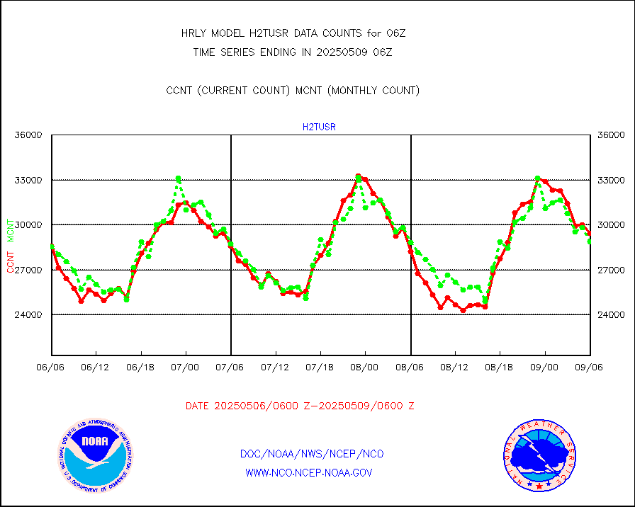
h2tusr |
GOES-16&up/NESDIS wv imgr/cld-top derived cld mtn |
26219 |
27197 |
96.4 % |
2005.00-2005.99 |
ifeunb |
METEOSAT/EUMETSAT ir lg-wave drv cld motion NBseq |
20985 |
21423 |
98.0 % |
2004.50-2005.49 |
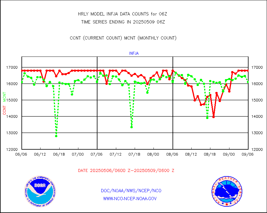
infja |
MTSAT/JMA infrared long-wave derived cloud motion |
16731 |
15872 |
105.4 % |
2003.50-2004.49 |
infmo |
MODIS (AQUA/TERRA) ir l-wave derived cloud motion |
0 |
0 |
n/a |
2002.00-2002.99 |
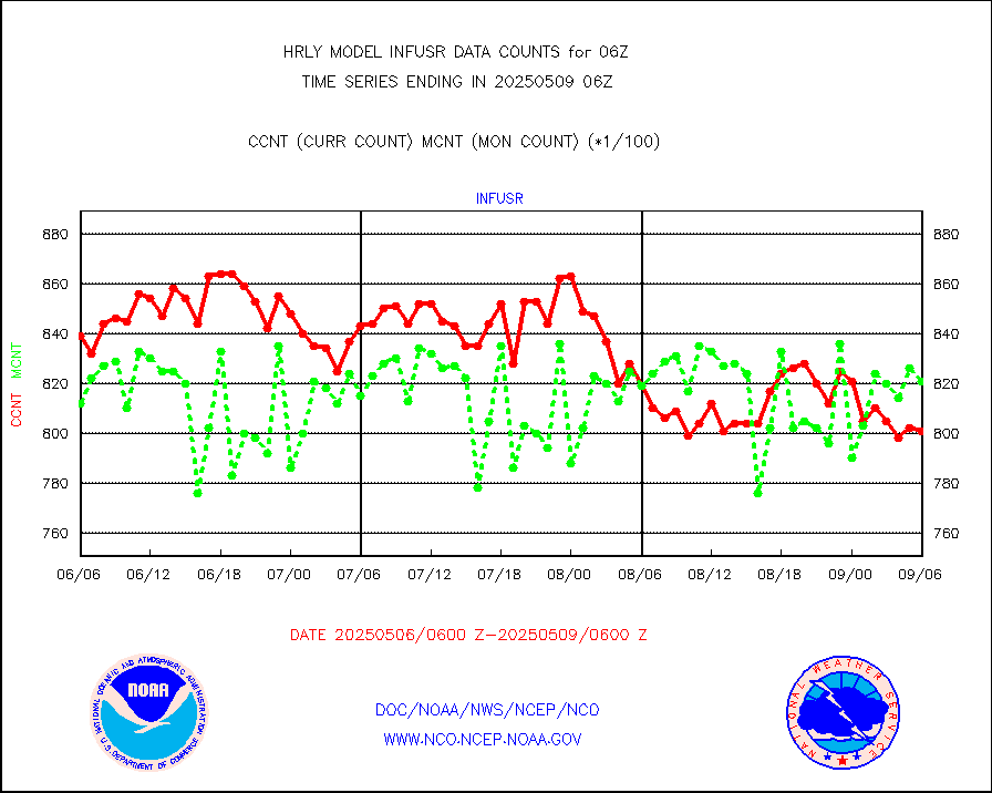
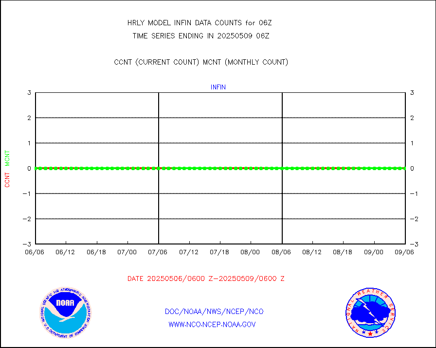
infusr |
GOES-16&up/NESDIS ir long-wave derived cld motion |
74916 |
81312 |
92.1 % |
2005.00-2005.99 |
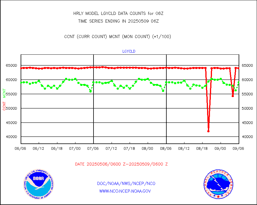
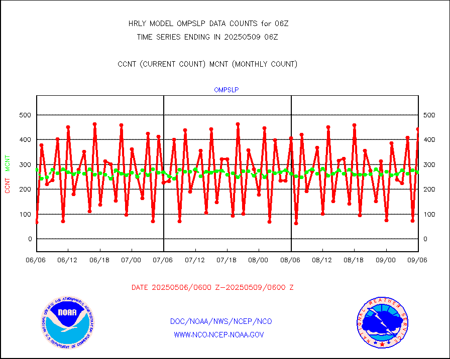
lgycld |
GOES/NASA(Langley) hi-res. (1x1 f-o-v) cloud data |
4215033 |
3584908 |
117.6 % |
2005.50-2006.49 |
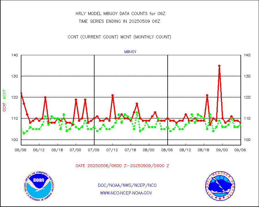
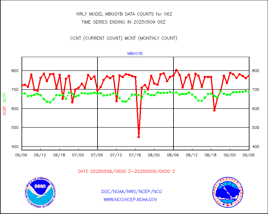
mbuoy |
Buoys decoded from FM-13 format (moored) |
119 |
108 |
110.2 % |
2005.50-2006.49 |
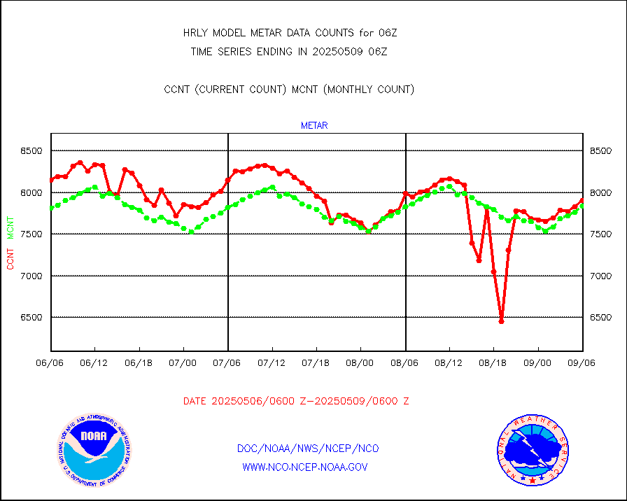
metar |
Aviation - METAR |
7709 |
7833 |
98.4 % |
2005.50-2006.49 |
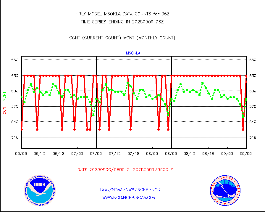
mso470 |
Mesonet/MADIS Colorado E-470 (Interstate 470) |
7 |
20 |
35.0 % |
2005.50-2006.49 |
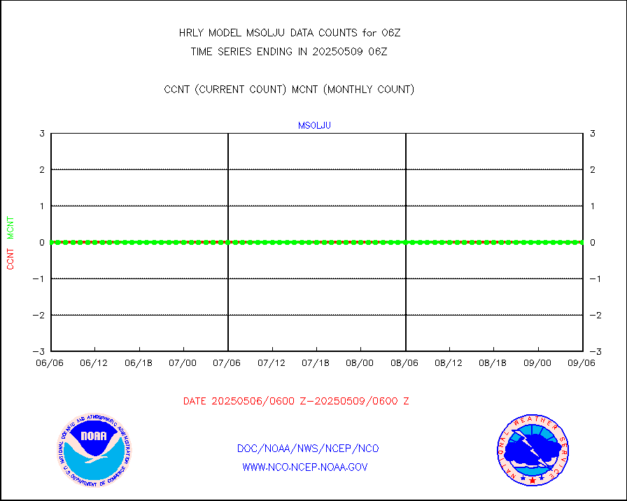
msoalk |
Mesonet/MADIS Alaska Department of Transportation |
108 |
107 |
100.9 % |
2005.50-2006.49 |
msoapg |
Mesonet/MADIS U.S. Army Aberdeen Proving Grounds |
0 |
0 |
n/a |
2005.50-2006.49 |
msoapr |
Mesonet/MADIS Citizen Weather Observers Program |
49862 |
49407 |
100.9 % |
2005.50-2006.49 |
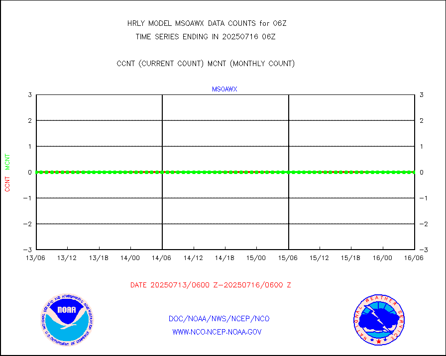
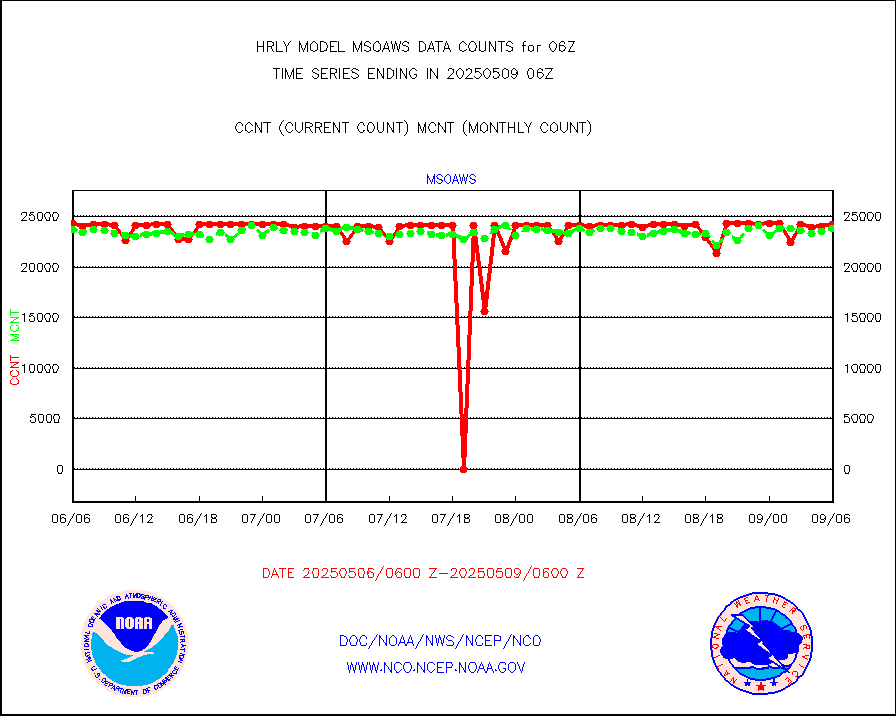
msoaws |
Mesonet/MADIS AWS Convergence Technologies, Inc. |
24773 |
25719 |
96.3 % |
2005.50-2006.49 |
msoawx |
Mesonet/MADIS "Anything Weather" |
0 |
0 |
n/a |
2005.50-2006.49 |
msocol |
Mesonet/MADIS Colorado Dept. of Transportation |
0 |
0 |
n/a |
2005.50-2006.49 |
msodcn |
Mesonet/MADIS DC Net |
0 |
0 |
n/a |
2005.50-2006.49 |
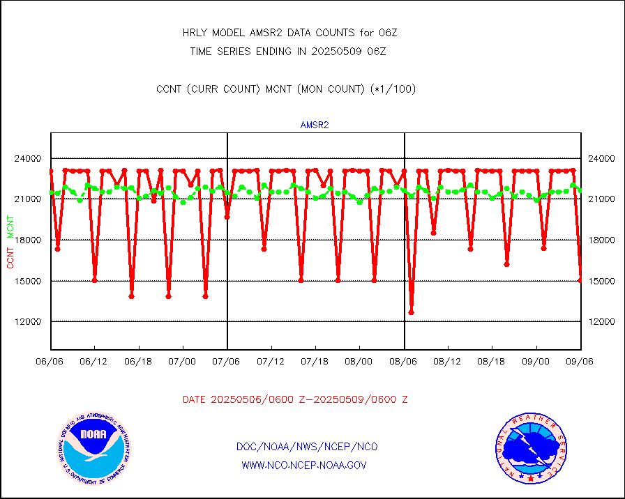
msoden |
Mesonet/MADIS Denver Urban Drainage & Flood Cntrl |
250 |
250 |
100.0 % |
2005.50-2006.49 |
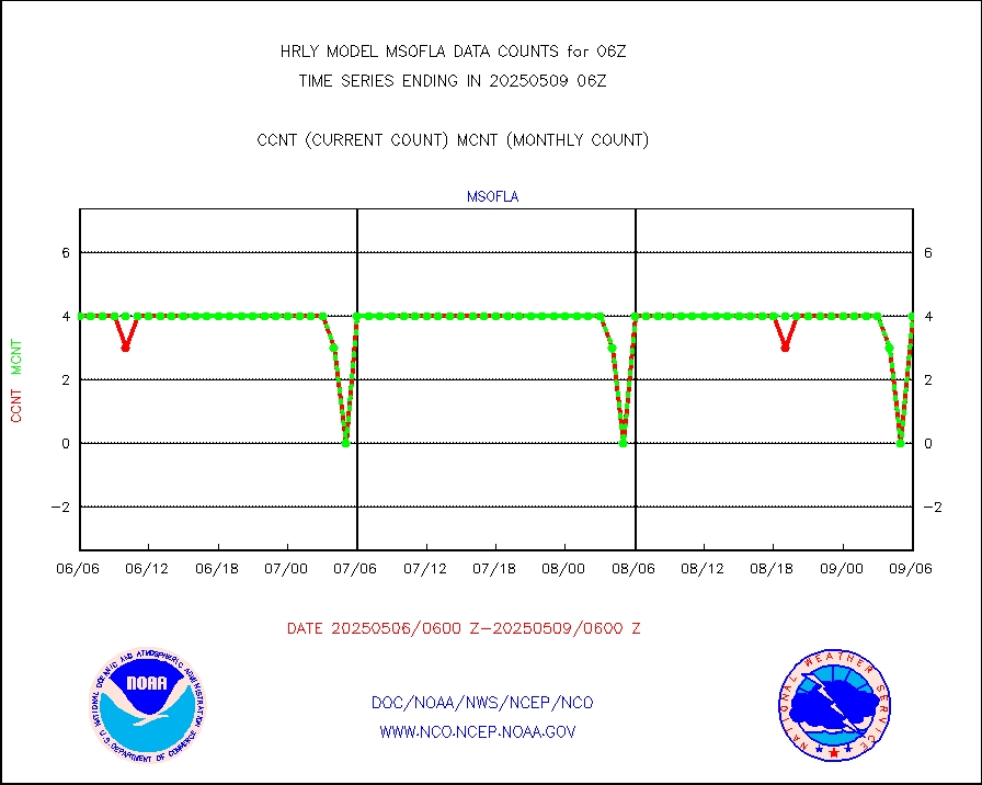
msofla |
Mesonet/MADIS Florida (FAWN & USF) |
4 |
4 |
100.0 % |
2005.50-2006.49 |
msoflt |
Mesonet/MADIS Florida Dept. of Transportation |
0 |
0 |
n/a |
2005.50-2006.49 |
msogeo |
Mesonet/MADIS Georgia Dept. of Transportation |
0 |
0 |
n/a |
2005.50-2006.49 |
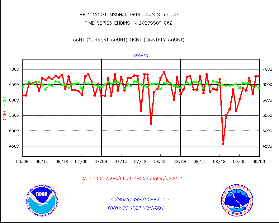
msohad |
Mesonet/MADIS NWS Hydromet Auto Data System(HADS) |
6836 |
6688 |
102.2 % |
2005.50-2006.49 |
msoien |
Mesonet/MADIS Iowa Environmental |
184 |
185 |
99.5 % |
2005.50-2006.49 |
msoind |
Mesonet/MADIS Indiana Dept. of Transportation |
0 |
0 |
n/a |
2005.50-2006.49 |
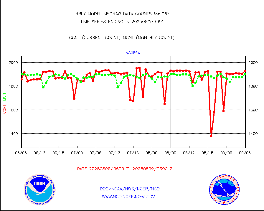
msoiow |
Mesonet/MADIS Iowa Department of Transportation |
0 |
0 |
n/a |
2005.50-2006.49 |
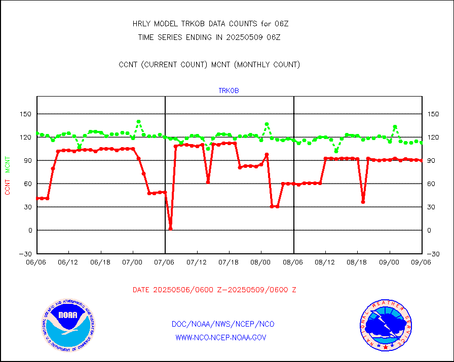
msokan |
Mesonet/MADIS Kansas Department of Transportation |
330 |
363 |
90.9 % |
2005.50-2006.49 |
msokla |
Mesonet/MADIS Oklahoma Mesonet |
318 |
322 |
98.8 % |
2005.50-2006.49 |
msolju |
Mesonet/MADIS Louisiana State/Jackson State Univ. |
0 |
0 |
n/a |
2005.50-2006.49 |
msomca |
Mesonet/MADIS Missouri Commercial Agricult Wx Net |
281 |
275 |
102.2 % |
2005.50-2006.49 |
msomin |
Mesonet/MADIS Minnesota Dept. of Transportation |
0 |
0 |
n/a |
2005.50-2006.49 |
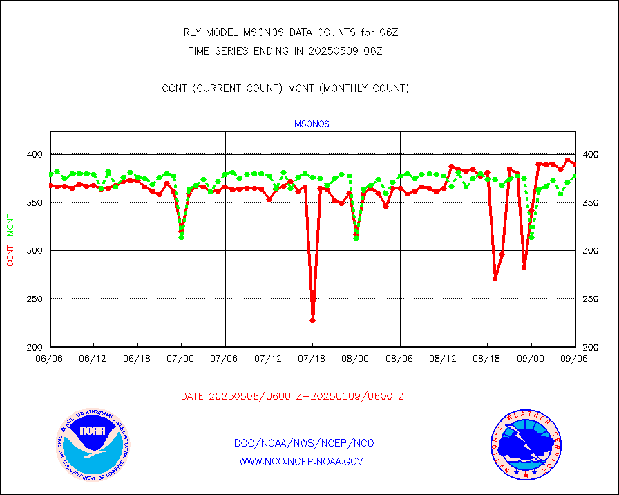
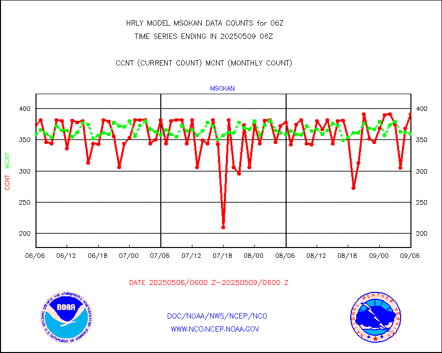
msonos |
Mesonet/MADIS NOS-Phys Oceanographic Realtime Sys |
388 |
383 |
101.3 % |
2005.50-2006.49 |
msoraw |
Mesonet/MADIS NFIC Remote Automated Wx Stns(RAWS) |
1891 |
1893 |
99.9 % |
2005.50-2006.49 |
msovir |
Mesonet/MADIS Virginia Dept. of Transportation |
74 |
226 |
32.7 % |
2005.50-2006.49 |
msowfy |
Mesonet/MADIS "Weather for You" |
0 |
0 |
n/a |
2005.50-2006.49 |
msowis |
Mesonet/MADIS Wisconsin Dept. of Transportation |
0 |
0 |
n/a |
2005.50-2006.49 |
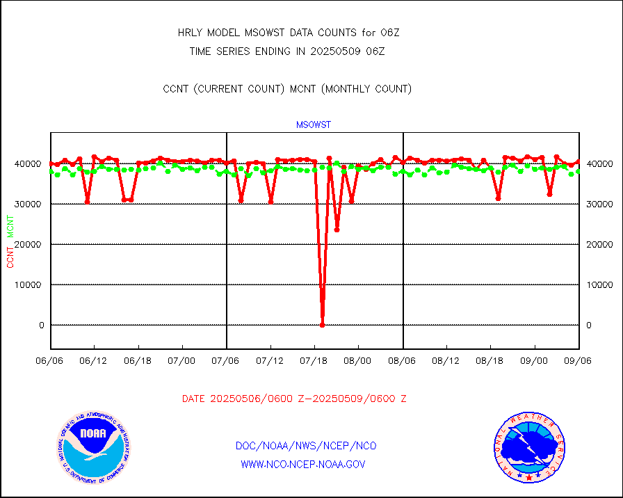
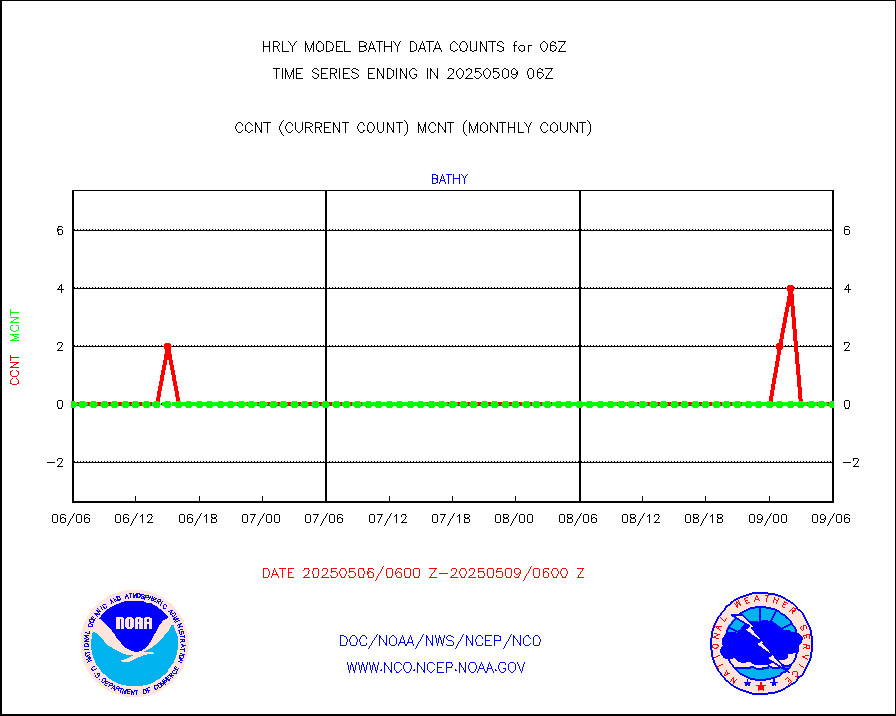
msowst |
Mesonet/MADIS MesoWest (many subproviders) |
46247 |
46039 |
100.5 % |
2005.50-2006.49 |
msowtx |
Mesonet/MADIS West Texas |
5658 |
5601 |
101.0 % |
2005.50-2006.49 |
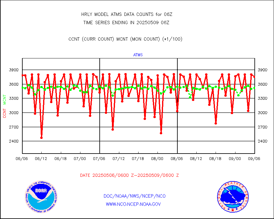
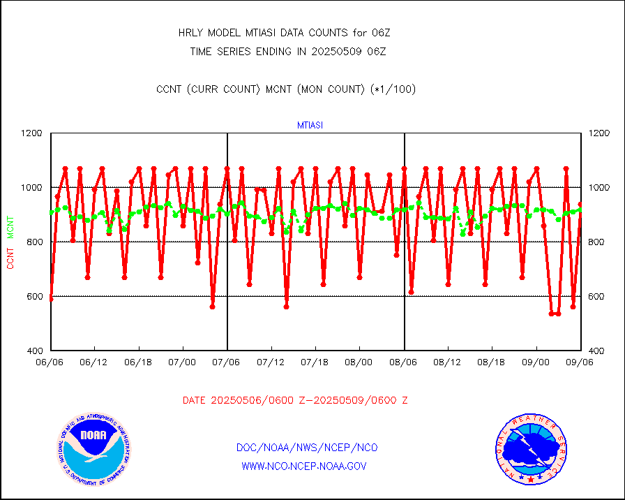
mtiasi |
METOP 1-2 IASI 1C radiance data (varbl. channels) |
106932 |
82177 |
130.1 % |
2004.00-2004.99 |
nxrdw |
NEXRAD Vel Azm Dsp(VAD) winds via radar coded msg |
0 |
0 |
n/a |
2005.50-2006.49 |
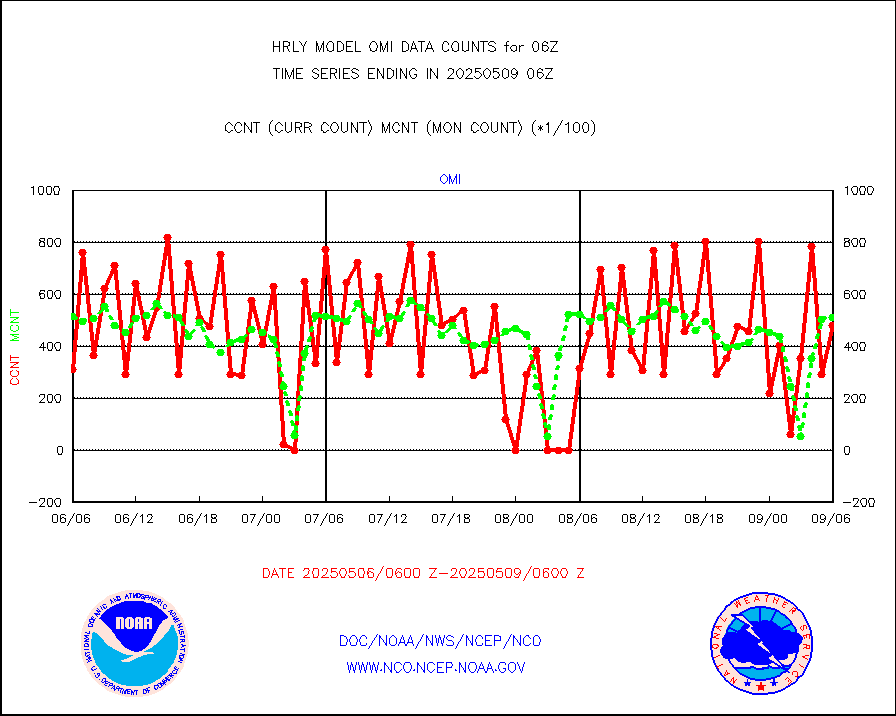
omi |
Aura Ozone Monitoring Instrument (OMI) data |
65160 |
36704 |
177.5 % |
2003.50-2004.49 |
osbuv8 |
NOAA 16-19 Solar Backscatter UV-2 rad frm V8 BUFR |
0 |
0 |
n/a |
2004.00-2004.99 |
pibal |
PIBAL (from PILOT, PILOT SHIP, PILOT MOBIL) |
42 |
38 |
110.5 % |
2005.50-2006.49 |
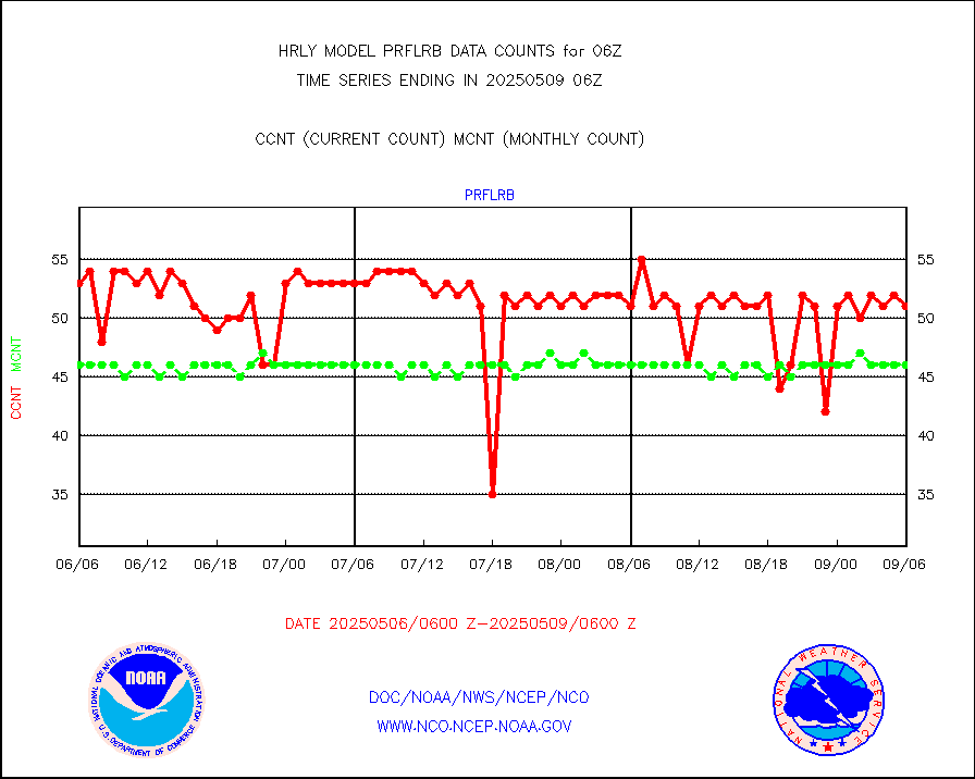
prflrb |
Multi-Agency Profiler (MAP) and SODAR winds |
34 |
41 |
82.9 % |
2005.50-2006.49 |
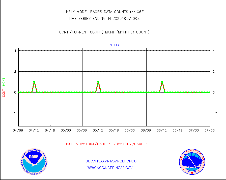
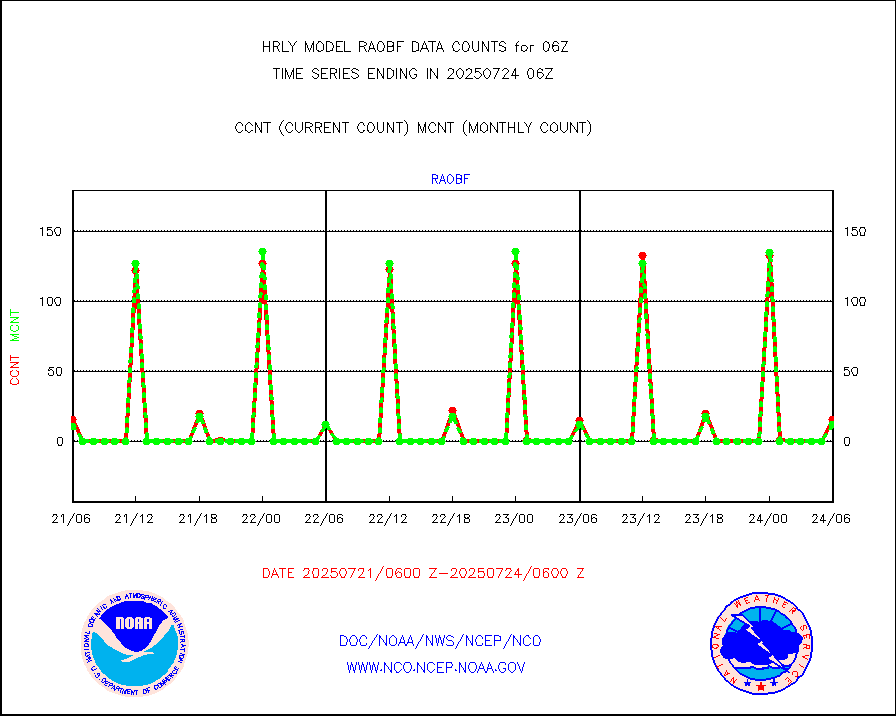
raobf |
Rawinsonde - fixed land (from TEMP or PILOT) |
10 |
10 |
100.0 % |
2005.50-2006.49 |
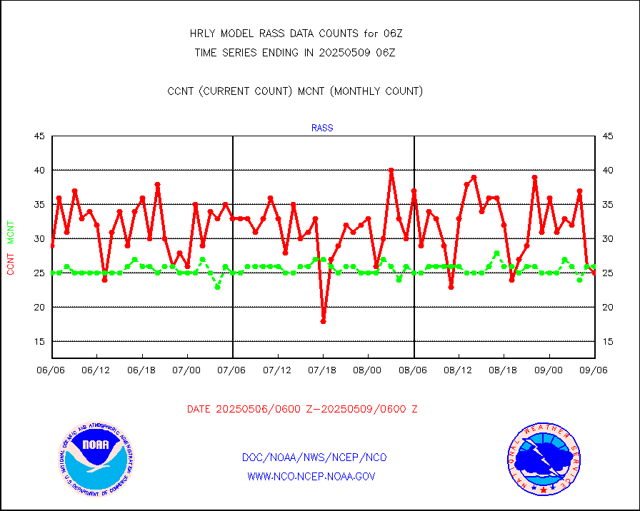
rass |
RASS temperatures (NOAA and Multi-Agency) |
16 |
26 |
61.5 % |
2005.50-2006.49 |
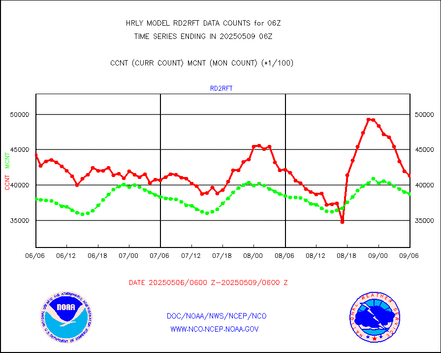
rd2rft |
NEXRAD reflectivity (Lvl 2 - GTS) |
3888944 |
3991380 |
97.4 % |
2005.50-2006.49 |
rd2wnd |
NEXRAD radial wind (Level 2 - GTS) |
1607049 |
1448497 |
110.9 % |
2005.50-2006.49 |
sevcsr |
METEOSAT-10 2nd Gen SEVIRI Clr Sky Radiance(proc) |
0 |
0 |
n/a |
2005.50-2006.49 |
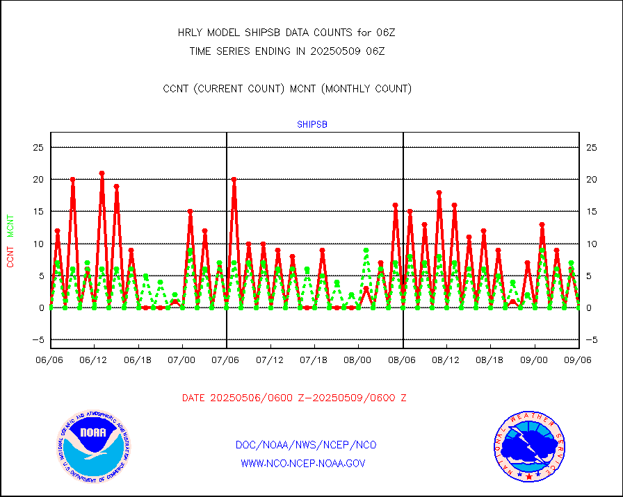
shipsb |
Ship - manual and automatic, restricted (BUFR) |
0 |
0 |
n/a |
2005.50-2006.50 |
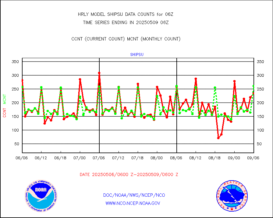
shipsu |
Ship - manual and automatic, unrestricted |
200 |
167 |
119.8 % |
2005.50-2006.50 |
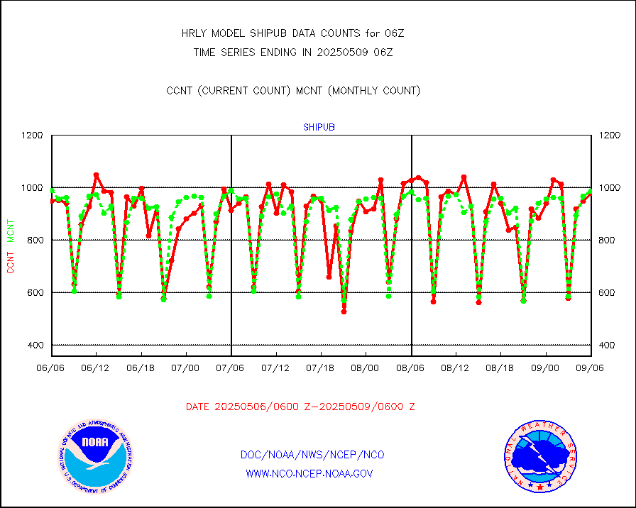
shipub |
Ship - manual and automatic, unrestricted (BUFR) |
796 |
879 |
90.6 % |
2005.50-2006.50 |
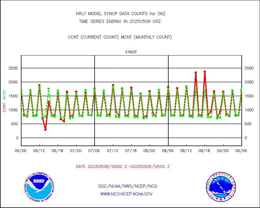
synop |
Synoptic - fixed manual and automatic |
1985 |
1978 |
100.4 % |
2005.50-2006.49 |
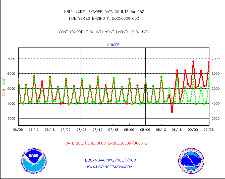
synopb |
Synoptic - fixed manual & auto (decoded fr BUFR) |
5887 |
5805 |
101.4 % |
2005.50-2006.49 |
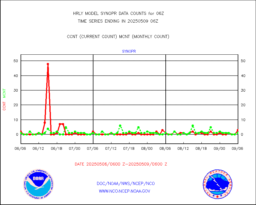
synopr |
Synoptic - restricted (WMO Res 40) manual & auto. |
0 |
1 |
0.0 % |
2005.50-2006.49 |
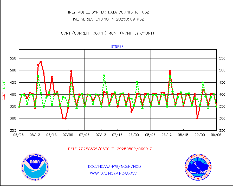
synpbr |
Synoptic - restricted (WMO Res 40)(decoded BUFR) |
347 |
348 |
99.7 % |
2005.50-2006.49 |
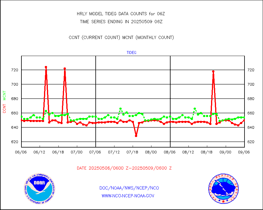
tideg |
Tide gauge reports decoded from CREX format |
647 |
642 |
100.8 % |
2005.00-2005.99 |
| Data Types of Opportunity with Normal Counts |
|---|
| Type | Description | Hourly Count | Monthly Average | Percent (%) of Monthly Mean | UTC Time Window |
3p9usr |
GOES-16&up/NESDIS ir short-wv derived cld motion |
36593 |
41933 |
87.3 % |
2005.00-2005.99 |
acarsa |
MDCRS ACARS acft data (ARINC via AFWA)(AIREP fmt) |
0 |
0 |
n/a |
2005.50-2006.49 |
ahicsr |
Himawari Clear Sky Radiance |
0 |
0 |
n/a |
2005.00-2005.99 |
amsr2 |
GCOM-W AMSR2 1B brightness temperatures |
2025648 |
2178641 |
93.0 % |
2004.00-2004.99 |
atmsdb |
NPP/NOAA-20 ATMS bright. temps-direct b-cast SSEC |
103004 |
79681 |
129.3 % |
2004.50-2005.49 |
atovs |
POES/NESDIS - processed ATOVS soundings/radiances |
0 |
0 |
n/a |
2004.00-2004.99 |
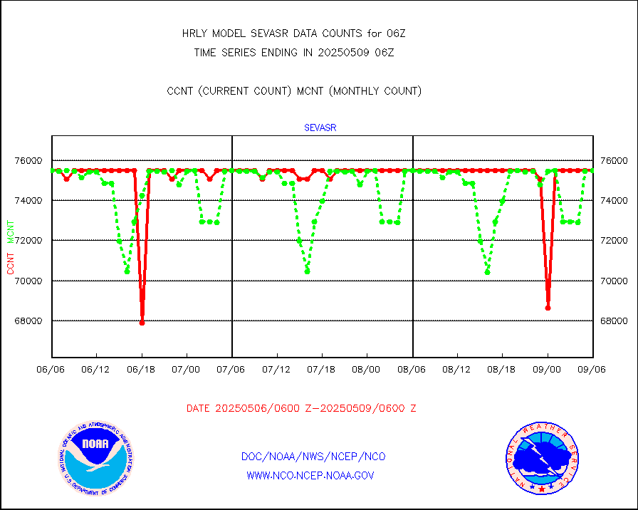
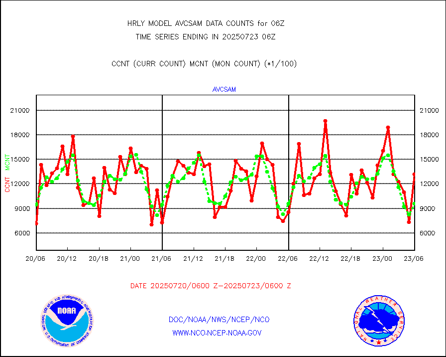
avcsam |
A.M.(N17,M2,M3) AVHRR GAC NCEP-proc clr&sea btmps |
939194 |
1200594 |
78.2 % |
2003.50-2004.49 |
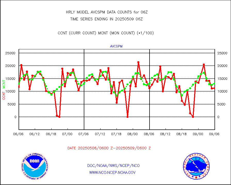
avcspm |
P.M.(N18-19) AVHRR GAC NCEP-proc clr & sea btemps |
1234045 |
1289293 |
95.7 % |
2003.50-2004.49 |
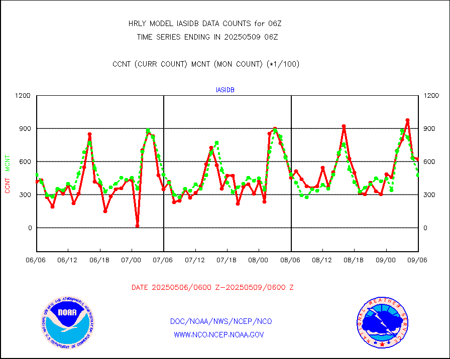
bathy |
eXpendable BathyThermograph, mooring (BATHY fmt) |
0 |
0 |
n/a |
1923.00-1923.99 |
coopmd |
Coop/MADIS NEPP & HCN-Modernization NOAA COOP Obs |
27 |
27 |
100.0 % |
2005.50-2006.49 |
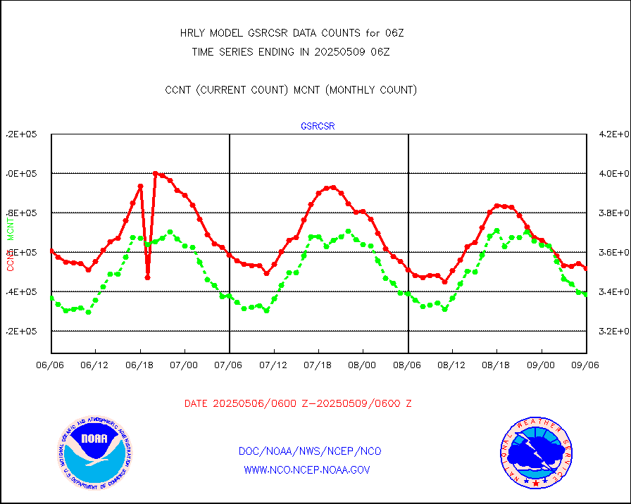
crisf4 |
NPP/NOAA-20 CrIS full spctrl radn (431 ch subset) |
240534 |
229999 |
104.6 % |
2004.50-2005.49 |
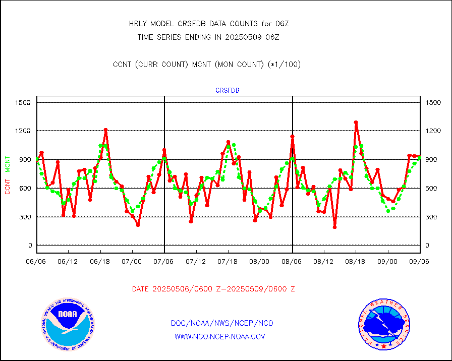
crsfdb |
NPP/NOAA-20 CrIS full spctrl radn dir brdcst SSEC |
155012 |
124477 |
124.5 % |
2004.50-2005.49 |
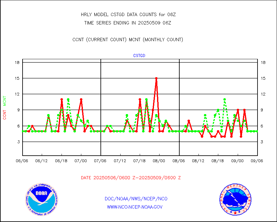
cstgd |
Coast Guard |
3 |
3 |
100.0 % |
2005.50-2006.50 |
dbuoyb |
Drifting buoys (decoded from BUFR) |
1426 |
1407 |
101.4 % |
2005.50-2006.50 |
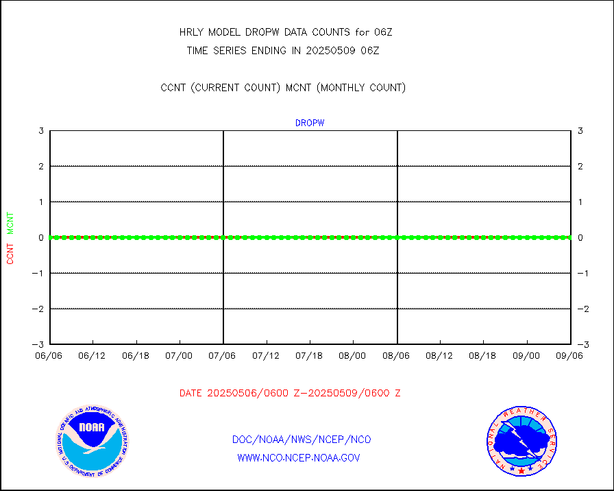
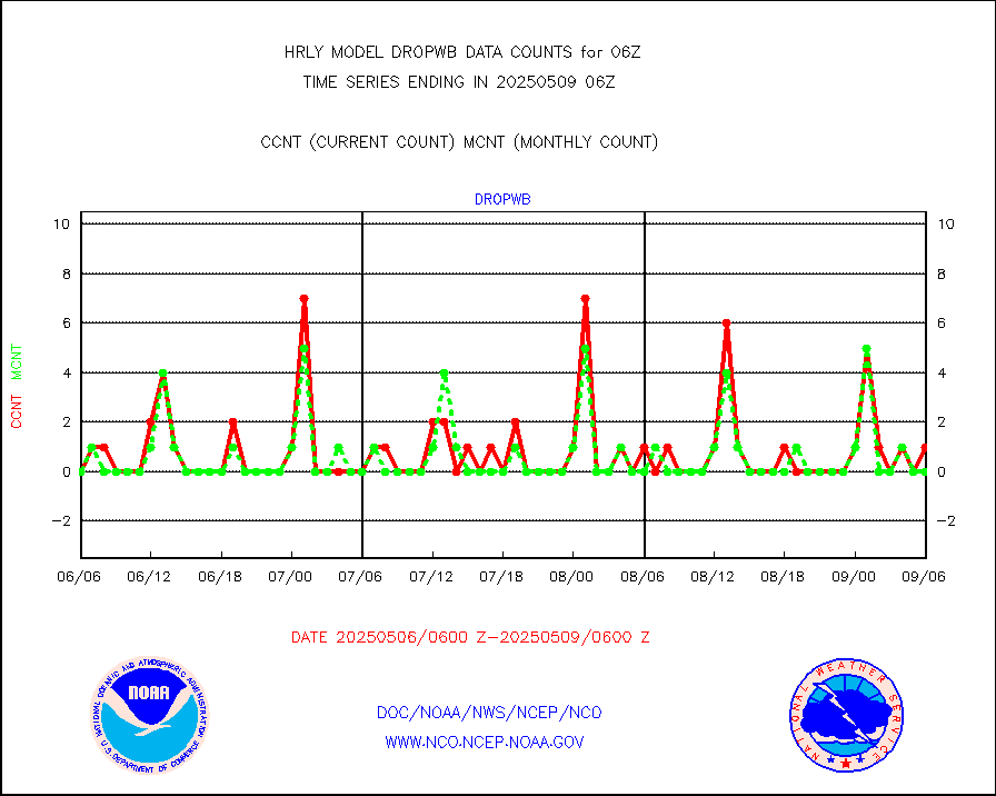
dropw |
Dropwinsonde (from TEMP DROP) |
0 |
0 |
n/a |
2005.50-2006.49 |
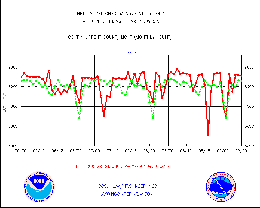
efclam |
GOES imager effective cloud amount data (U.Wisc.) |
8292372 |
8282777 |
100.1 % |
2005.50-2006.49 |
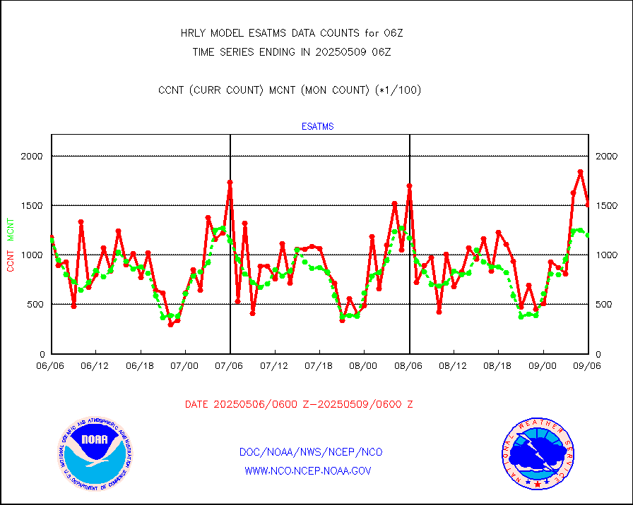
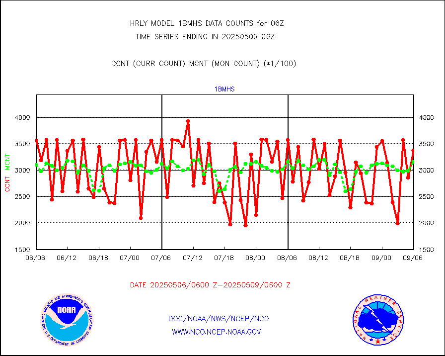
esatms |
NPP Adv. Tech. MW Sndr (ATMS) br. temps from RARS |
175196 |
114841 |
152.6 % |
2004.50-2005.49 |
esiasi |
METOP 1-2 IASI 1C radiance data vbl chn from RARS |
28552 |
20691 |
138.0 % |
2005.00-2005.99 |
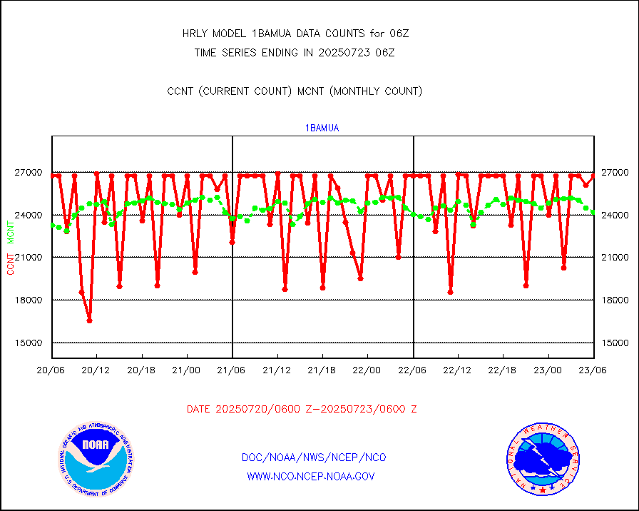
esmhs |
NOAA 18-19 & METOP 1-2 MHS proc. btemps from RARS |
111150 |
125129 |
88.8 % |
2005.50-2006.49 |
geoimr |
GOES/NESDIS (11x17 f-o-v) imager clear radiances |
0 |
0 |
n/a |
2005.00-2005.99 |
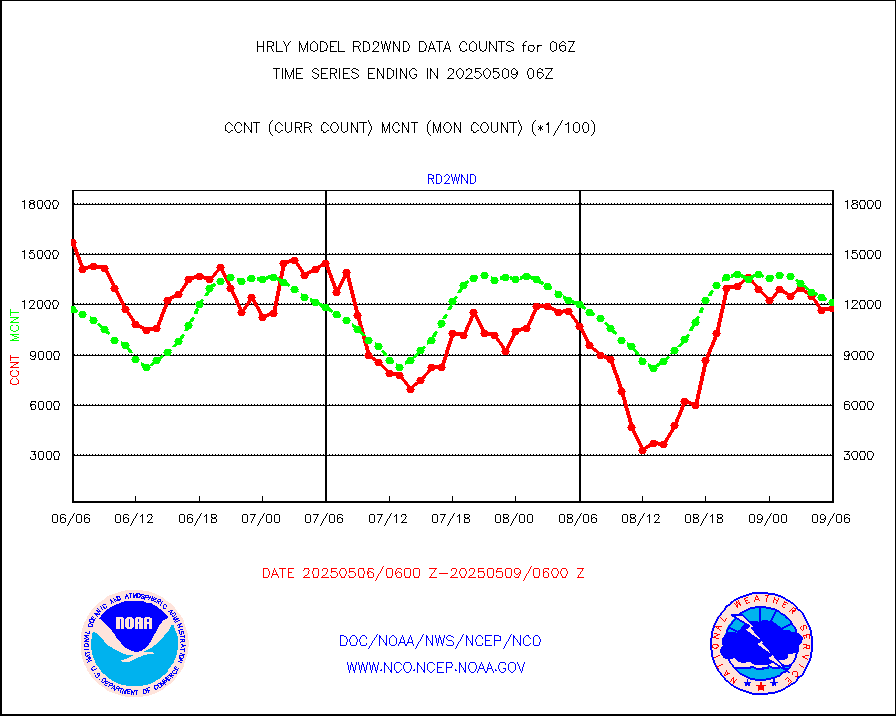
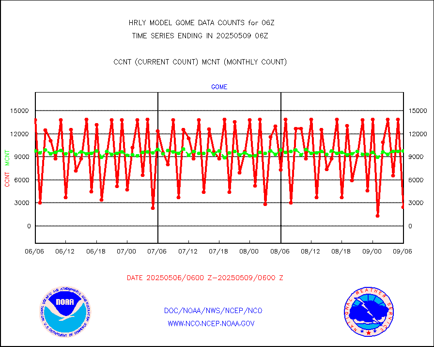
gome |
METOP 1-2 Global Ozone Monitoring Exp.-2 (GOME-2) |
7645 |
7010 |
109.1 % |
2004.50-2005.49 |
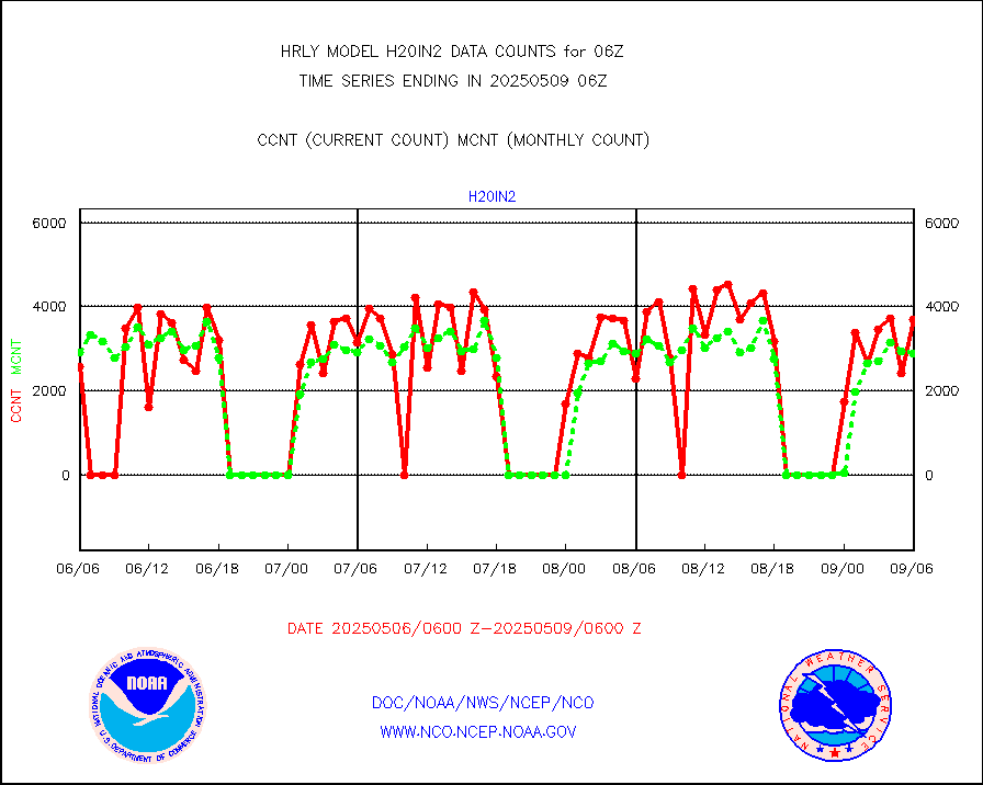
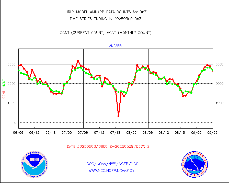
h20in2 |
INDIA SATWIND, INSAT WV channel |
4022 |
5895 |
68.2 % |
2005.00-2005.99 |
h2dusr |
GOES-16&up/NESDIS wv imgr/deep-lyr derivd cld mtn |
14462 |
15730 |
91.9 % |
2005.00-2005.99 |
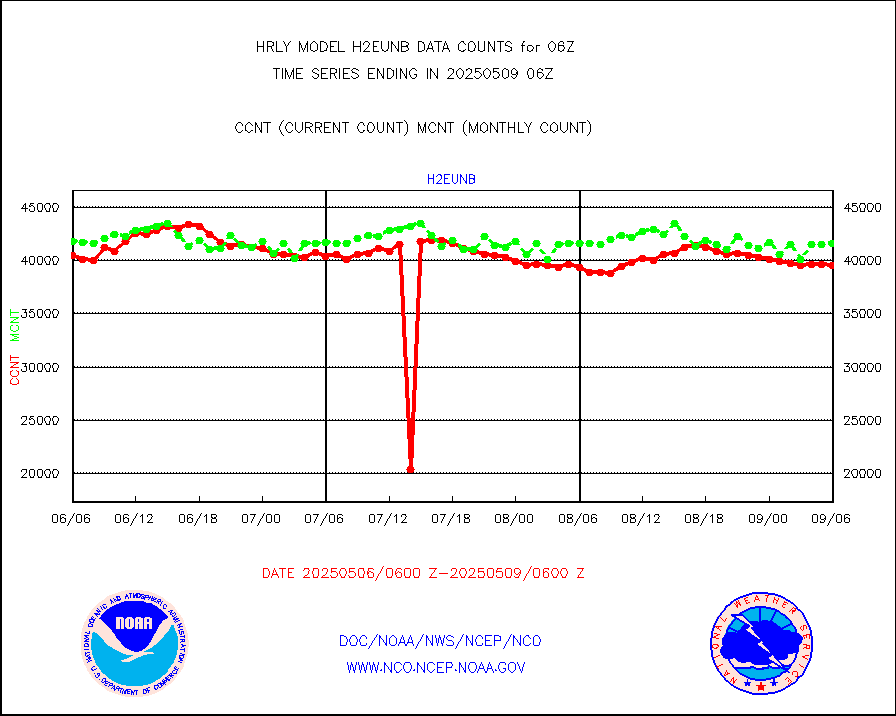
h2eunb |
METEOSAT/EUMETSAT wvpr imgr drv cld motion NBseq |
37997 |
40530 |
93.8 % |
2004.50-2005.49 |
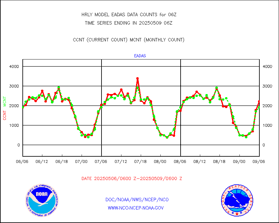
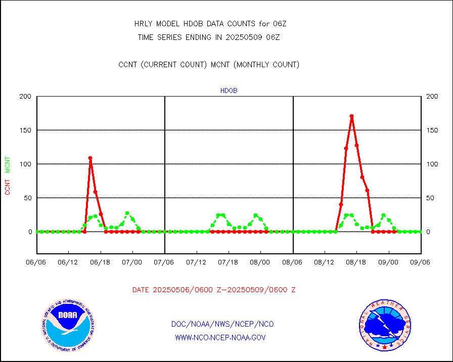
hdob |
High Density OBs from reconnaissance acft data |
0 |
3 |
0.0 % |
2005.50-2006.49 |
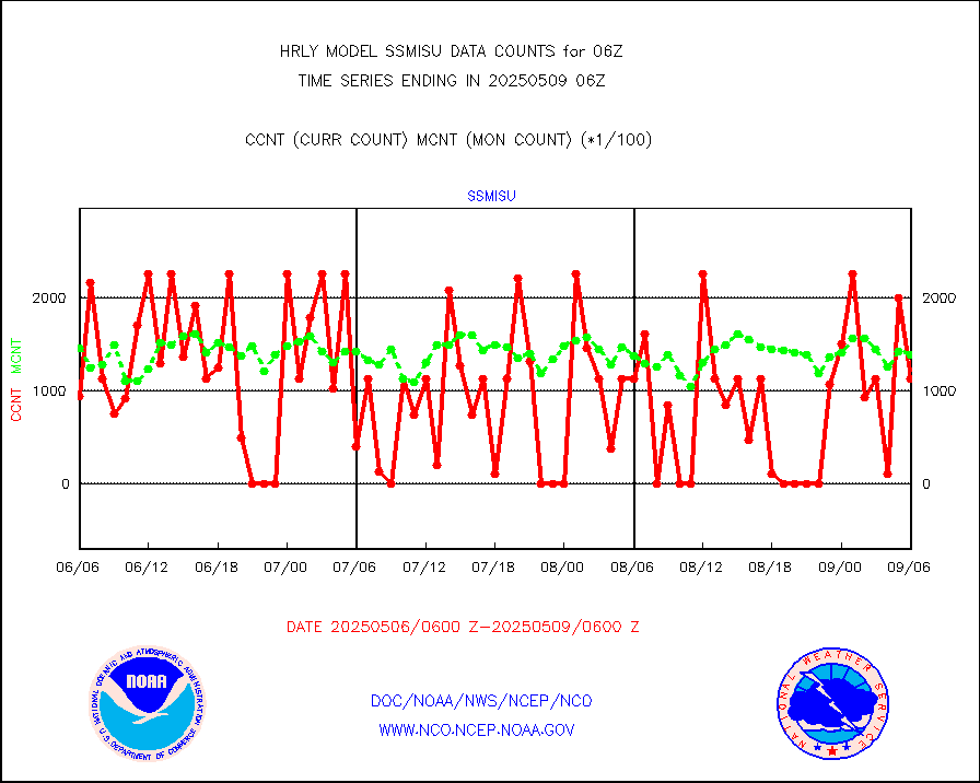
iasidb |
METOP 1-2 IASI 1C radiances-direct broadcast SSEC |
29682 |
33257 |
89.3 % |
2004.50-2005.49 |
ifvrnb |
VIIRS (NPP/NOAA-20) ir lg-wv drv cloud motion(NB) |
21378 |
18977 |
112.7 % |
2002.00-2002.99 |
infav |
AVHRR (NOAA/METOP) ir lg-wave derived cld motion |
0 |
0 |
n/a |
2002.00-2002.99 |
infav1 |
AVHRR (METOP) ir lg-wave derived cld motion |
0 |
0 |
n/a |
2005.50-2006.50 |
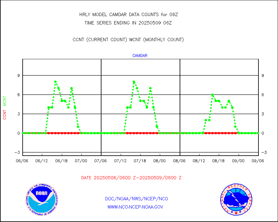
infin |
INSAT/KALPANA India ir lg-wave derived cld motion |
0 |
0 |
n/a |
2003.50-2004.49 |
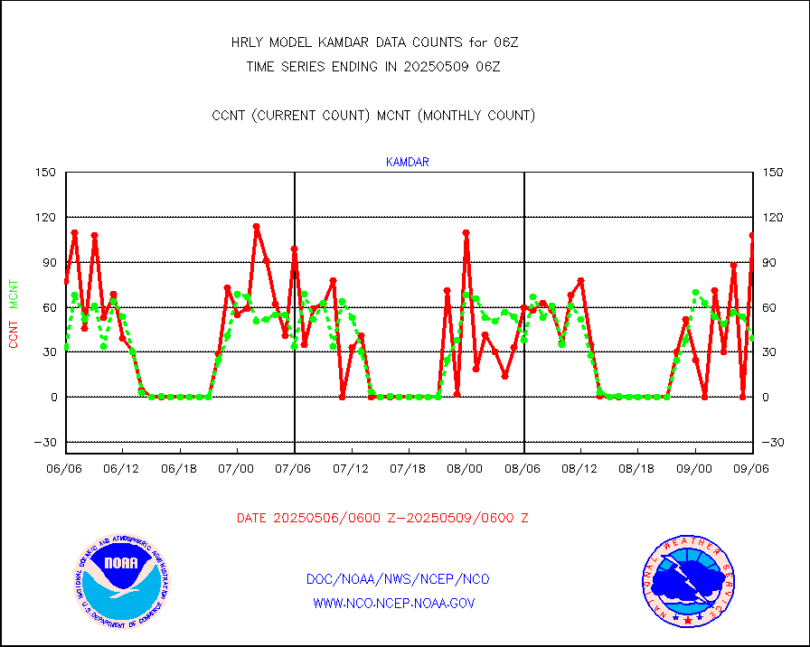
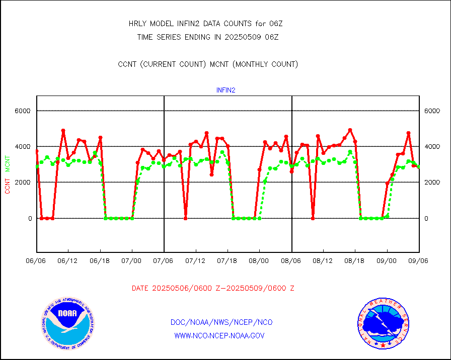
infin2 |
INDIA SATWIND, INSAT IR channel |
3072 |
5911 |
52.0 % |
2005.00-2005.99 |
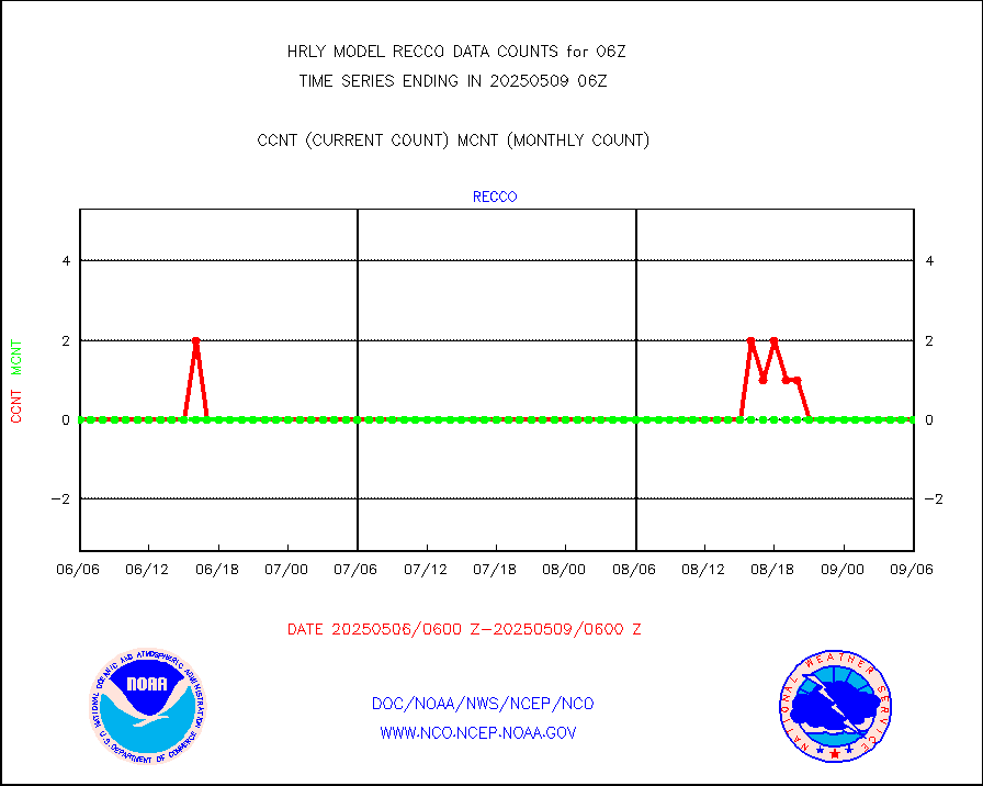
kamdar |
Korean AMDAR aircraft data (decoded from BUFR) |
52 |
49 |
106.1 % |
2005.50-2006.49 |
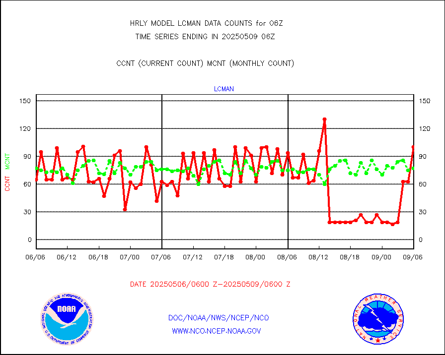
lcman |
Land-based CMAN stations decoded from CMAN format |
83 |
76 |
109.2 % |
2005.50-2006.49 |
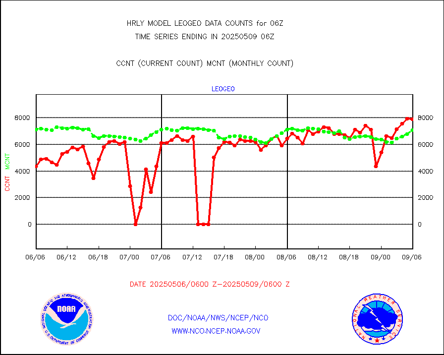
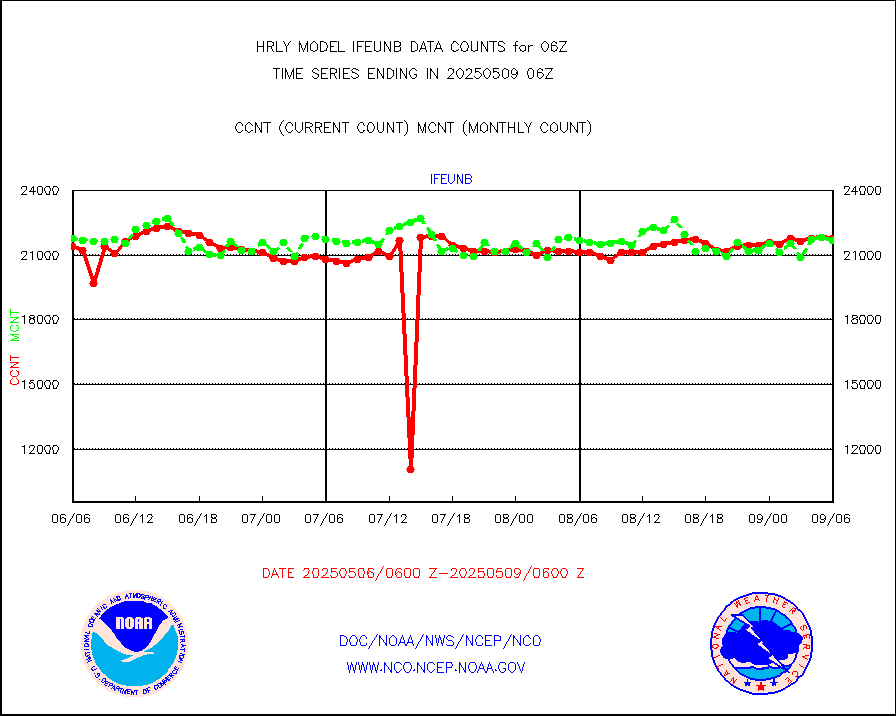
leogeo |
LEO-GEO satellite AMVs from UWisc. |
6762 |
5348 |
126.4 % |
2002.00-2002.99 |
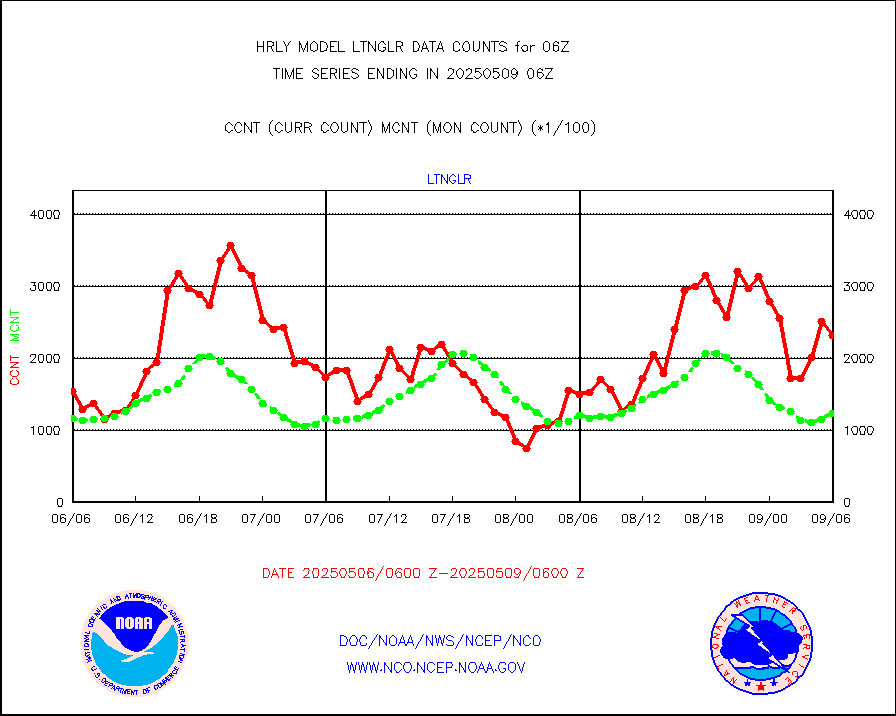
ltnglr |
LLDN Long-rng lightning from Vaisala via NOAAPORT |
123516 |
133334 |
92.6 % |
2005.50-2006.49 |
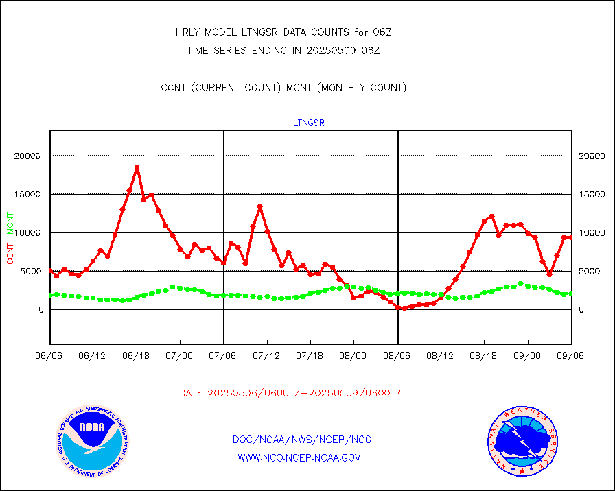
ltngsr |
NLDN Shrt-rng lightning from Vaisala via NOAAPORT |
5957 |
3509 |
169.8 % |
2005.50-2006.49 |
mbuoyb |
Moored buoys (decoded from BUFR) |
818 |
755 |
108.3 % |
2005.50-2006.50 |
mls |
Aura Microwave Limb Sounder (MLS) ozone data |
0 |
0 |
n/a |
2004.00-2004.99 |
msourb |
Mesonet/MADIS UrbaNet |
4362 |
4393 |
99.3 % |
2005.50-2006.49 |
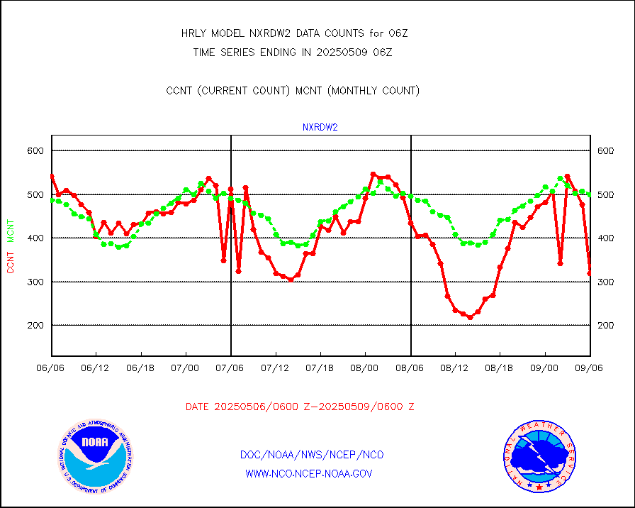
nxrdw2 |
NEXRAD Vel Azm Dsp(VAD) winds via Level 2 decoder |
687 |
625 |
109.9 % |
2005.50-2006.49 |
ompslp |
OMPS Limb Profiler ozone data (NPP) |
228 |
256 |
89.1 % |
1923.00-1923.99 |
ompsn8 |
OMPS nadir profile ozone (Version 8 BUFR) |
563 |
557 |
101.1 % |
2004.00-2004.99 |
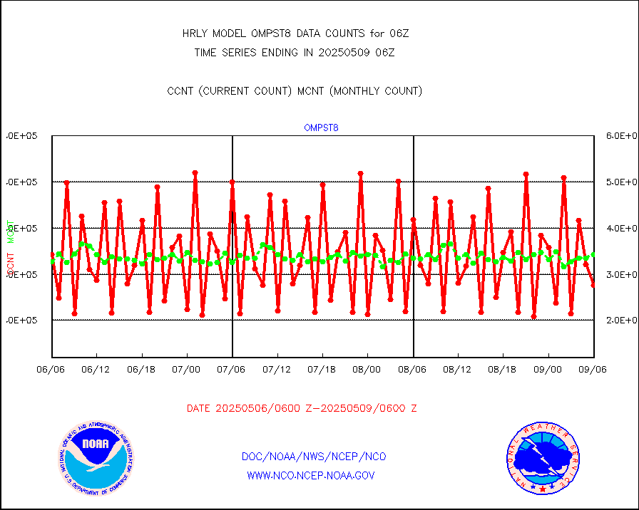
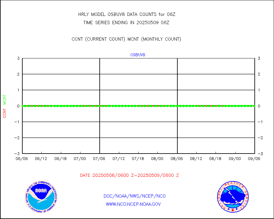
ompst8 |
OMPS total column ozone (Version 8 BUFR) |
501337 |
329485 |
152.2 % |
2004.00-2004.99 |
pirep |
Manual PIREP aircraft data (dcded from AIREP fmt) |
11 |
13 |
84.6 % |
2005.50-2006.49 |
prflrp |
Profilr winds from PIBAL (PILOT,PILOT SHIP/MOBIL) |
0 |
0 |
n/a |
2005.50-2006.49 |
raobm |
Rawinsonde - mobile land (from TEMP/PILOT MOBIL) |
0 |
0 |
n/a |
2005.50-2006.49 |
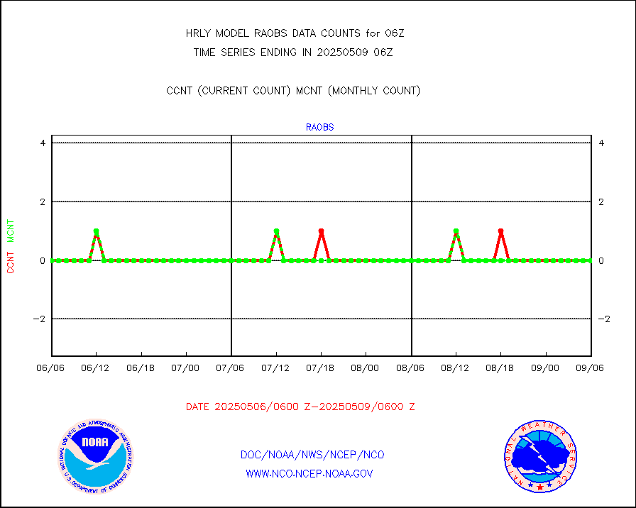
raobs |
Rawinsonde - ship (from TEMP SHIP, PILOT SHIP) |
0 |
0 |
n/a |
2005.50-2006.49 |
recco |
Flight level reconnaissance aircraft data |
0 |
0 |
n/a |
2005.50-2006.49 |
saphir |
Megha-Tropiques SAPHIR L1A2 brightness temps |
0 |
0 |
n/a |
2003.50-2004.49 |
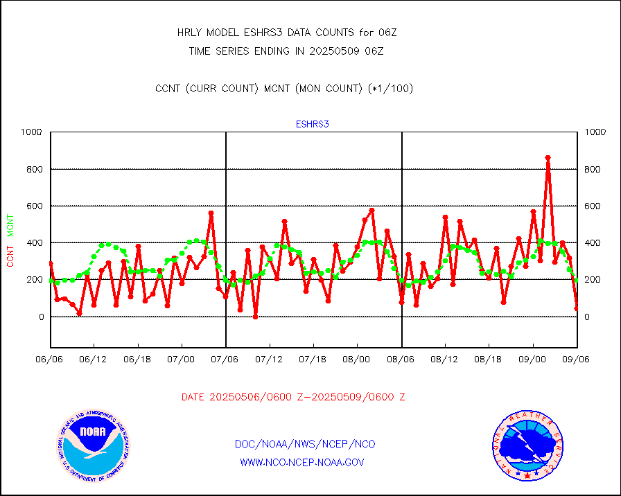
sevasr |
METEOSAT-10 2nd Gen SEVIRI All Sky Radiance(proc) |
75512 |
75512 |
100.0 % |
2005.50-2006.49 |
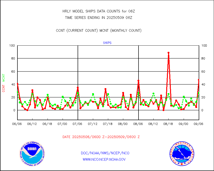
ships |
Ship - manual and automatic, restricted |
8 |
10 |
80.0 % |
2005.50-2006.49 |
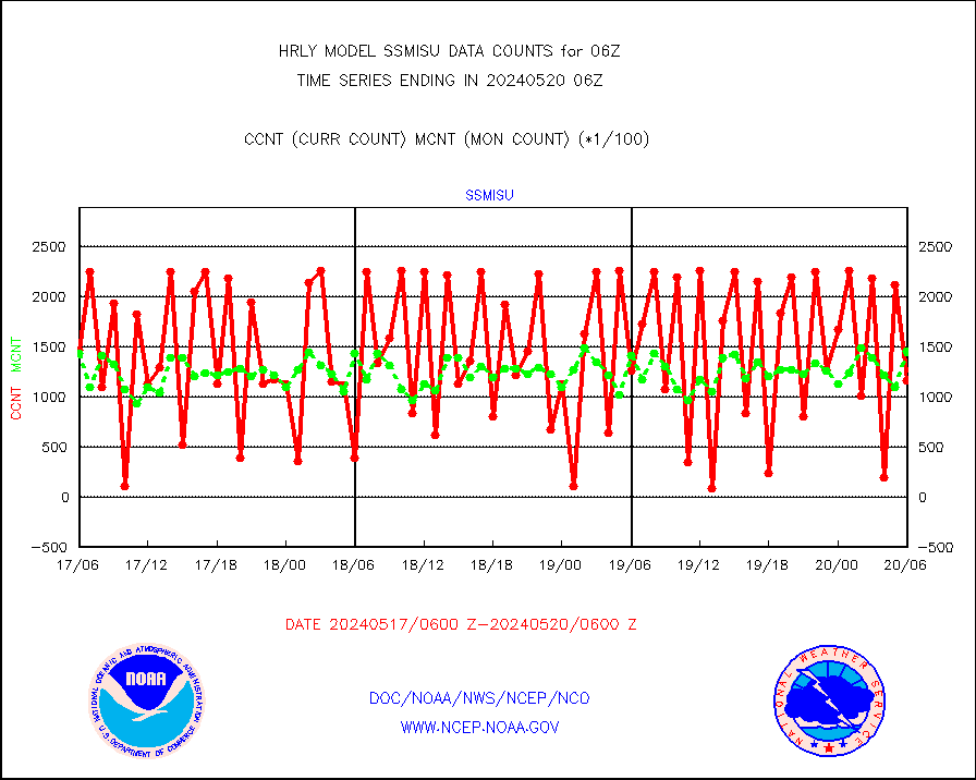
ssmisu |
DMSP SSM/IS 1C radiance data (Unified Pre-Proc.) |
115620 |
145412 |
79.5 % |
2004.50-2005.49 |
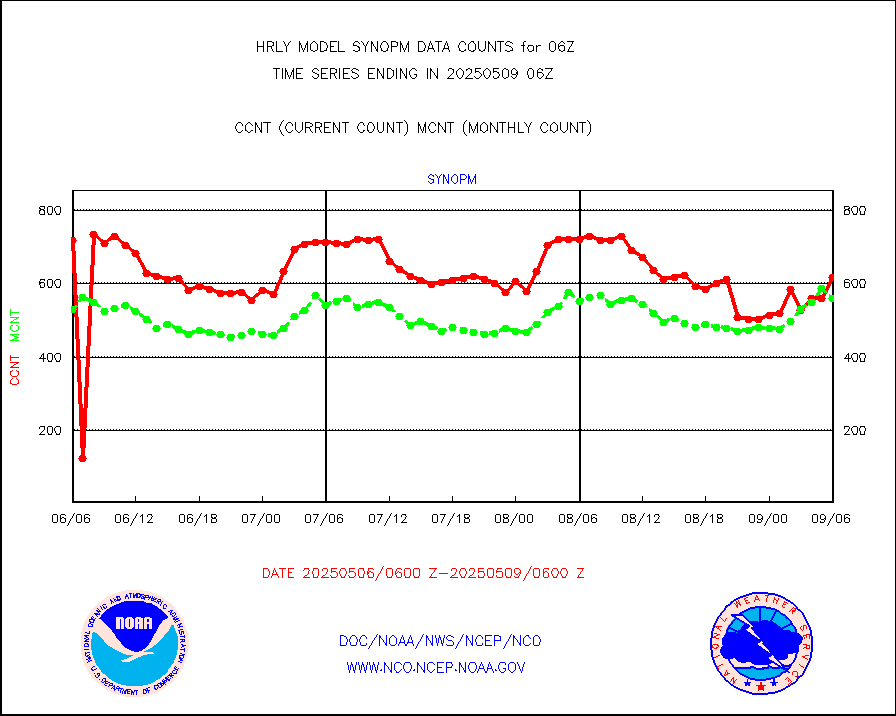
synopm |
Synoptic - mobile manual and automatic |
634 |
569 |
111.4 % |
2005.50-2006.49 |
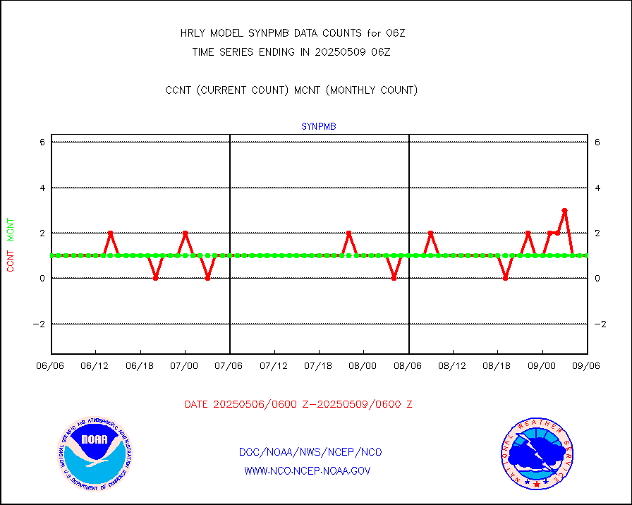
synpmb |
Synoptic - mobile manual & auto (decoded fr BUFR) |
0 |
1 |
0.0 % |
2005.50-2006.49 |
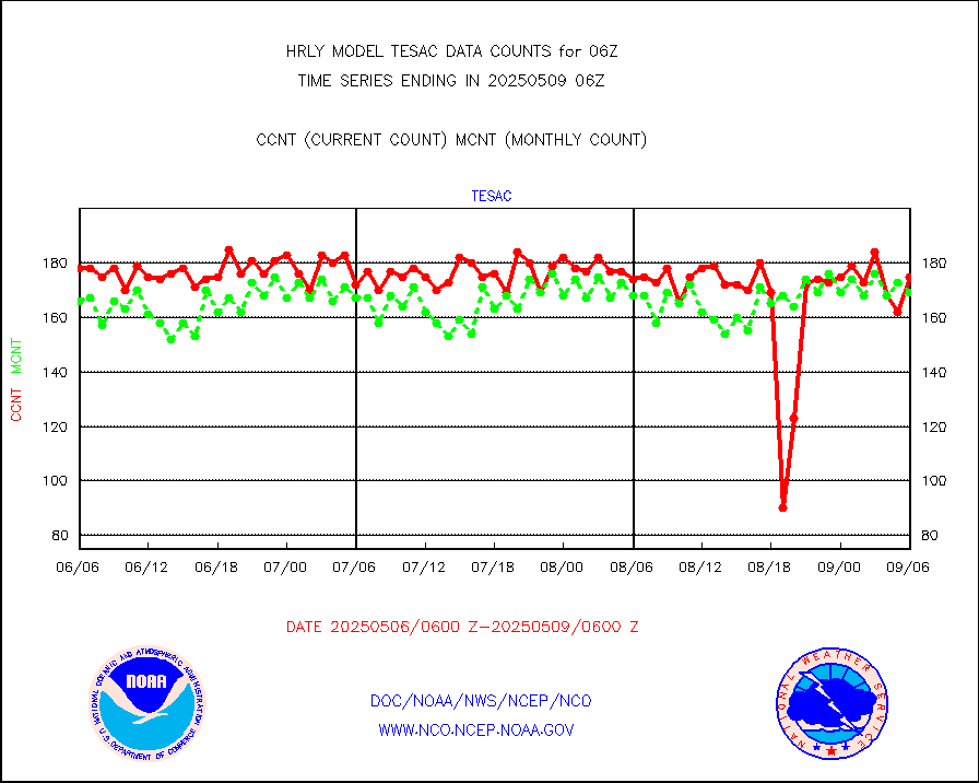
tesac |
CTD probe, Argo prflng float, mooring (TESAC fmt) |
202 |
192 |
105.2 % |
2005.50-2006.49 |
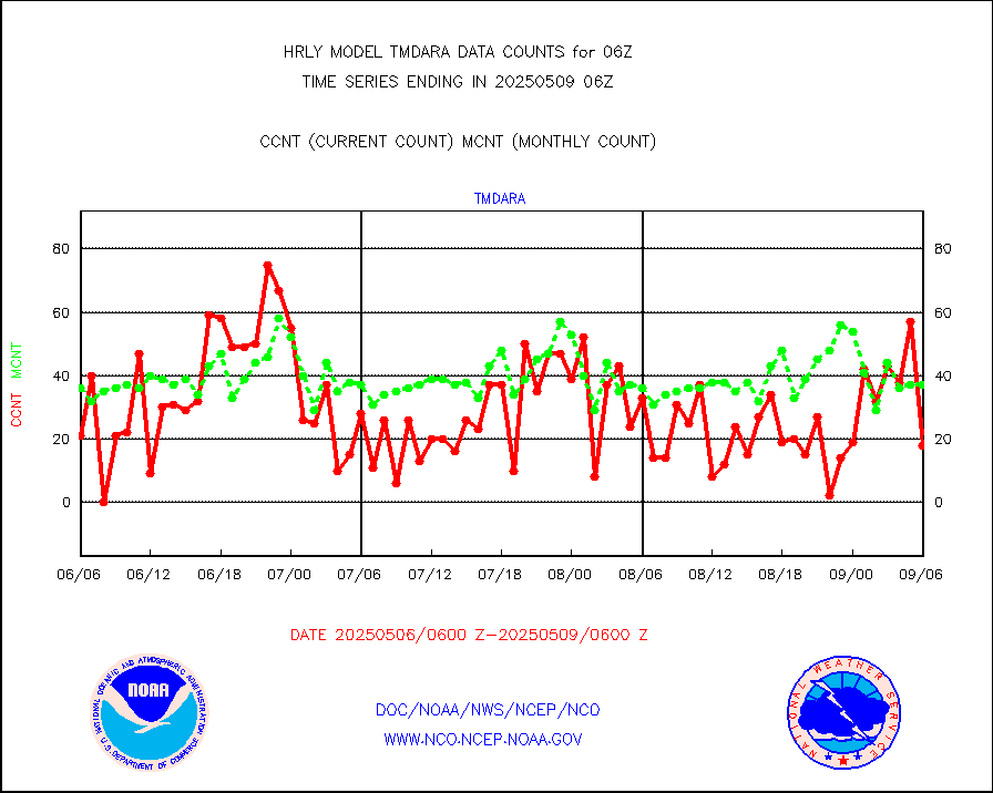
tmdara |
TAMDAR aircft data-all types(from Panasonic,BUFR) |
292 |
365 |
80.0 % |
2005.50-2006.49 |
trkob |
ThermoSalinoGraph (TSG) TRACKOB format) |
90 |
46 |
195.7 % |
2004.50-2005.49 |
visin |
INSAT/KALPANA India visible derived cloud motion |
0 |
0 |
n/a |
2003.50-2004.49 |
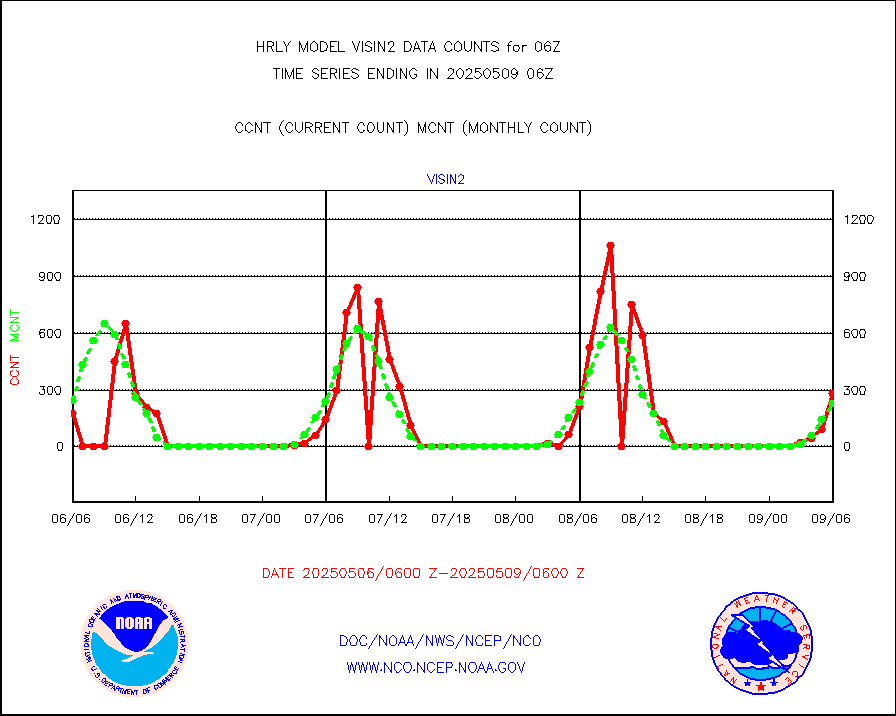
visin2 |
INDIA SATWIND, INSAT VIS channel |
531 |
455 |
116.7 % |
2005.00-2005.99 |
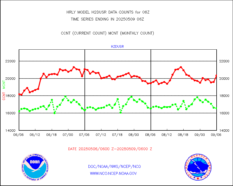
visja |
MTSAT/JMA visible derived cloud motion |
10920 |
10518 |
103.8 % |
2003.50-2004.49 |
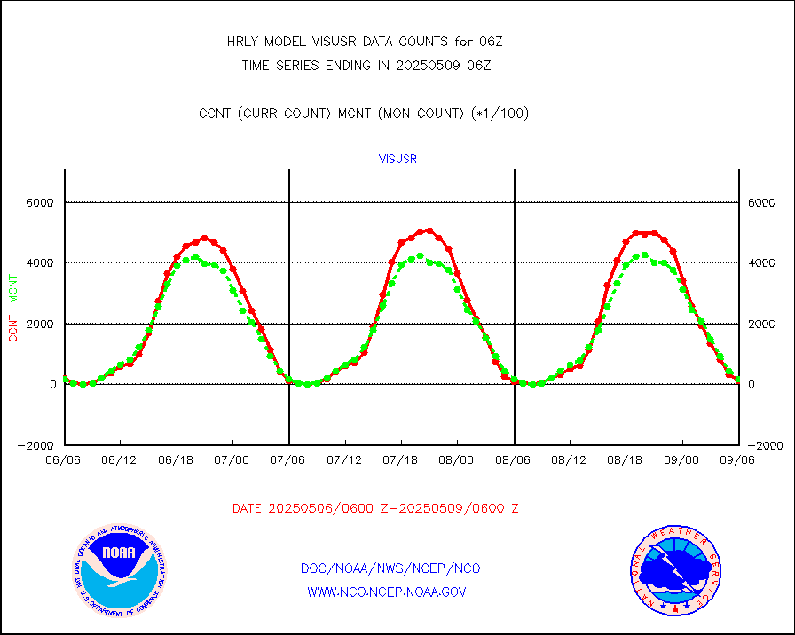
visusr |
GOES-16&up/NESDIS visible derived cloud motion |
20414 |
16728 |
122.0 % |
2005.00-2005.99 |
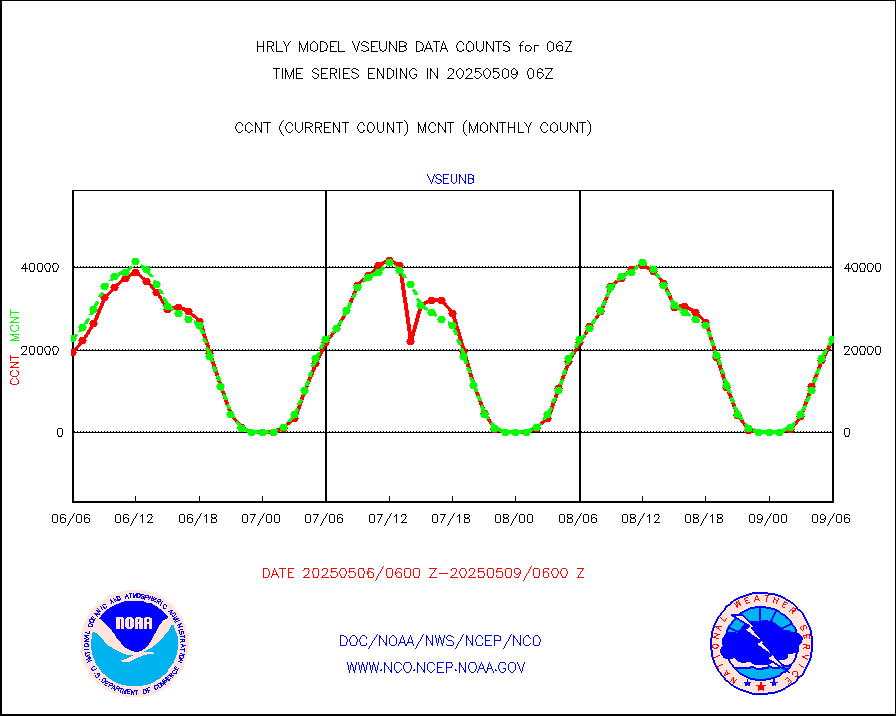
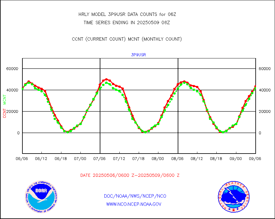
vseunb |
METEOSAT/EUMETSAT visible drv cld motion NBseq |
23500 |
20350 |
115.5 % |
2004.50-2005.49 |


