| Critical Data with Normal Counts |
|---|
| Type | Description | Hourly Count | Monthly Average | Percent (%) of Monthly Mean | UTC Time Window |
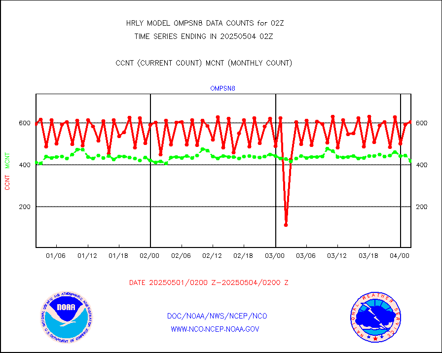
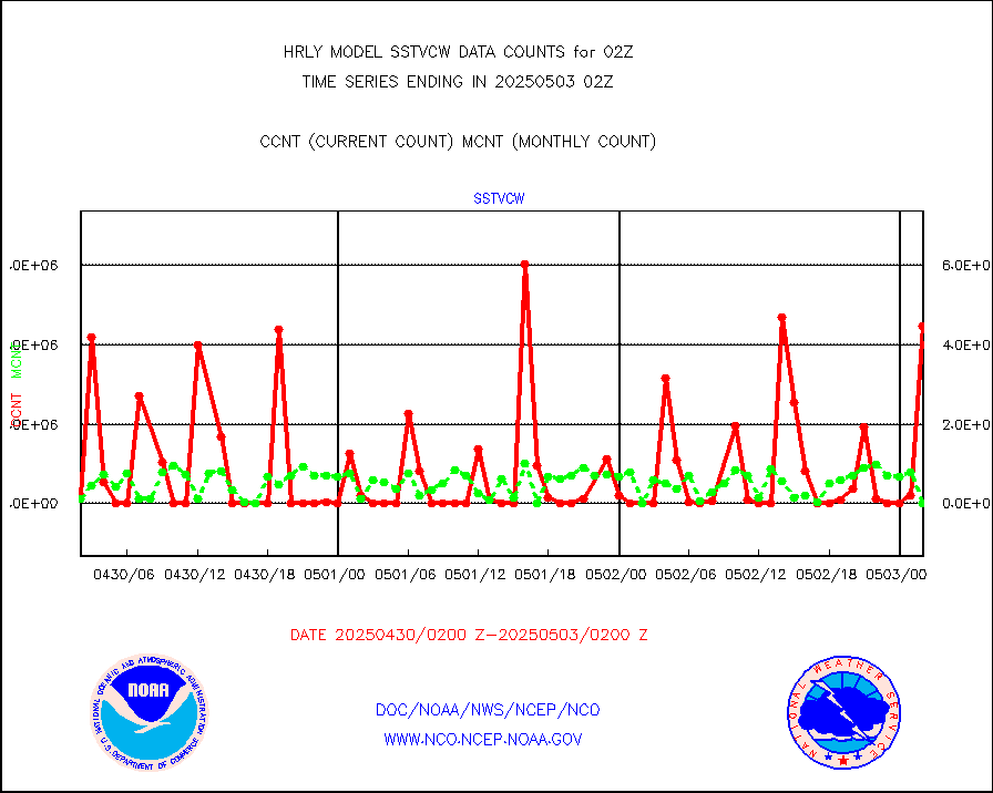
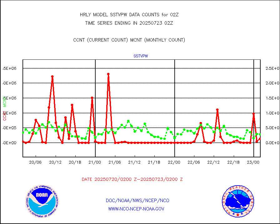
1bamua |
NOAA 15-19 & METOP 1-2 AMSU-A NCEP-proc. br.temps |
52551 |
50656 |
103.7 % |
2000.00-2000.99 |
1bhrs4 |
NOAA 18-19 & METOP 1-2 HIRS-4 NCEP-proc. br.temps |
58968 |
43188 |
136.5 % |
2000.00-2000.99 |
1bmhs |
NOAA 18-19 & METOP 1-2 MHS NCEP-proces. br. temps |
355629 |
294119 |
120.9 % |
2000.00-2000.99 |
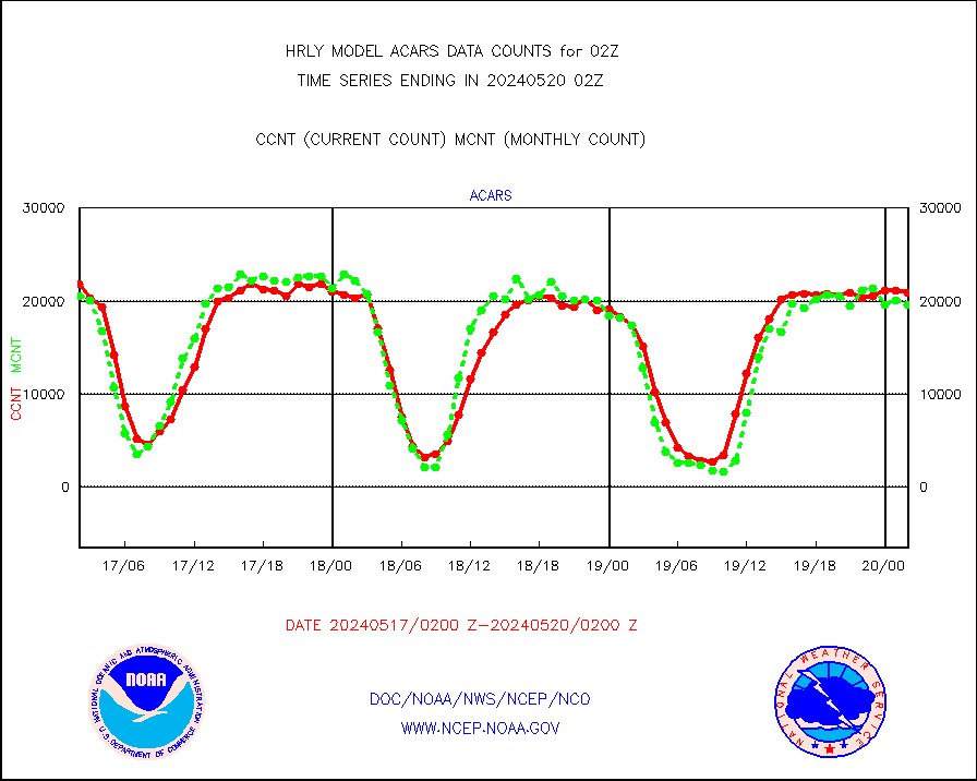
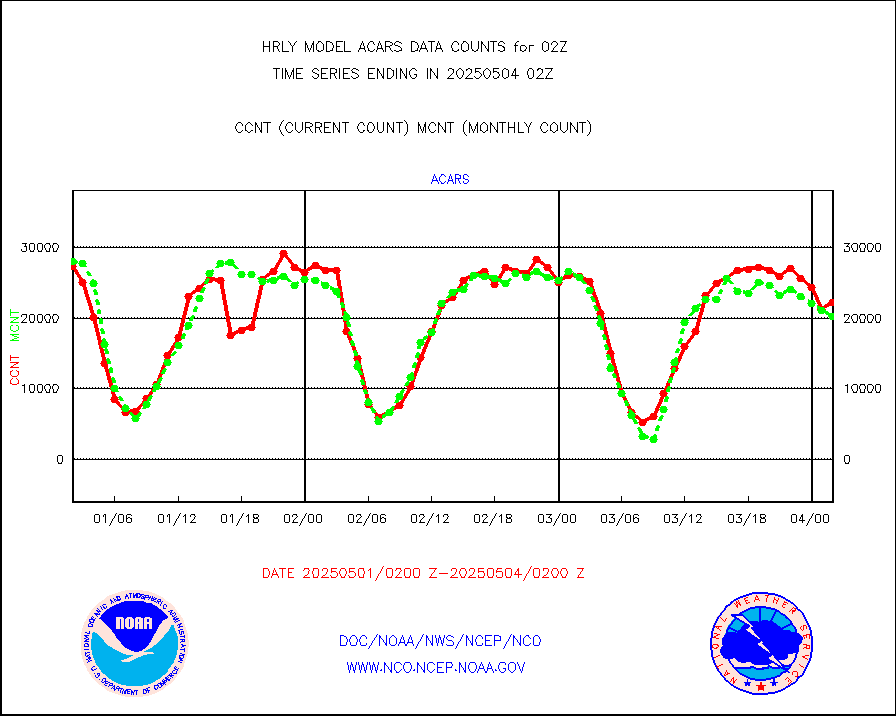
acars |
MDCRS ACARS acft data from ARINC(dcded from BUFR) |
20850 |
19612 |
106.3 % |
2001.50-2002.49 |
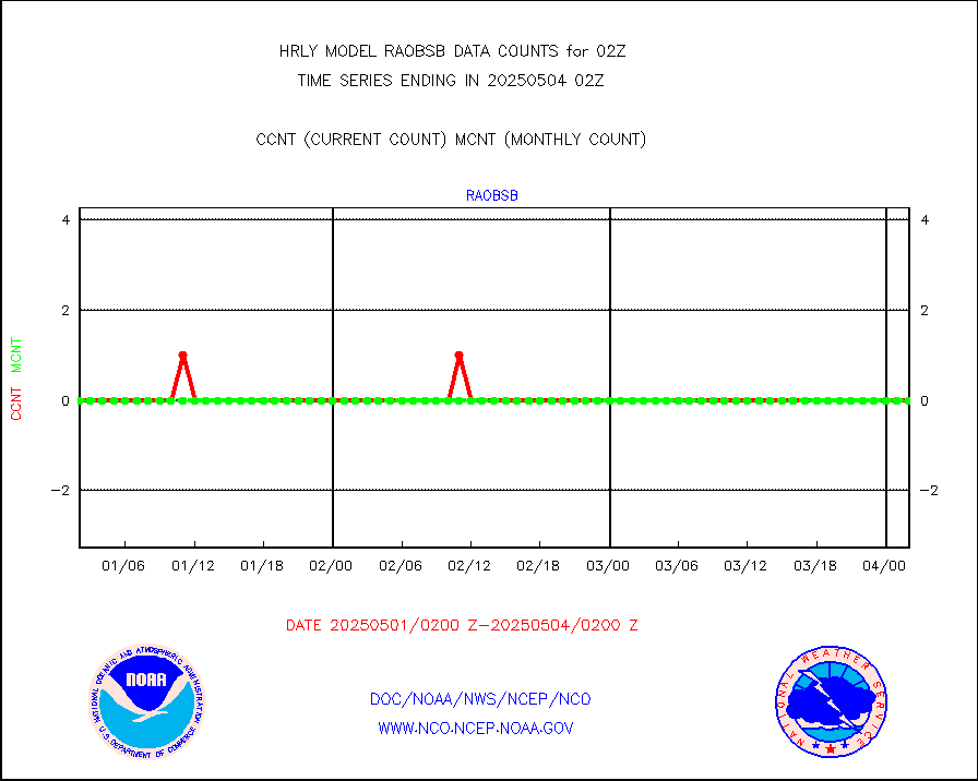
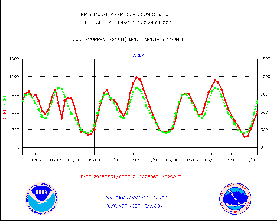
airep |
Manual AIREP aircraft data (dcded from AIREP fmt) |
1356 |
1204 |
112.6 % |
2001.50-2002.49 |
airsev |
AQUA AIRS/AMSU-A/HSB brightness temps- every FOV |
0 |
0 |
n/a |
1923.50-2000.49 |
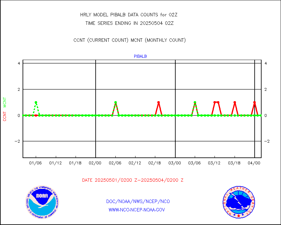
amdar |
AMDAR aircraft data (decoded from AMDAR format) |
388 |
313 |
124.0 % |
2001.50-2002.49 |
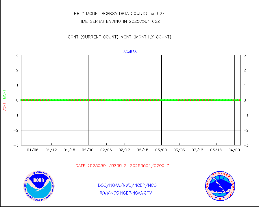
amdarb |
AMDAR aircraft data (decoded from BUFR) |
1449 |
1248 |
116.1 % |
2001.50-2002.49 |
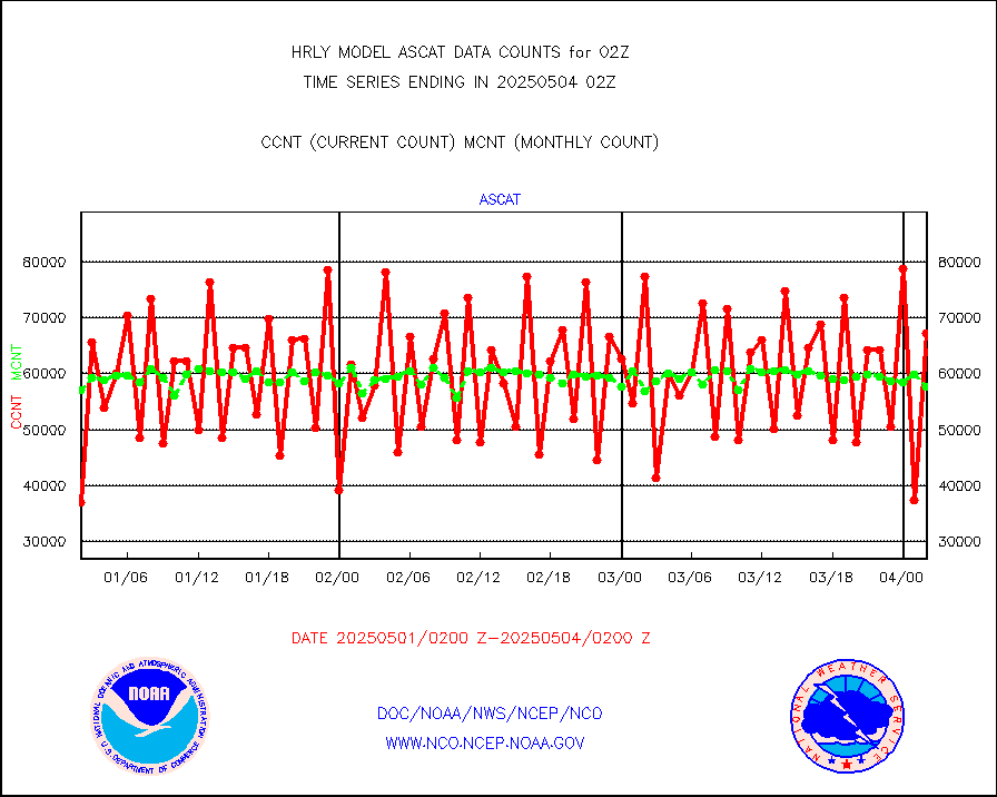
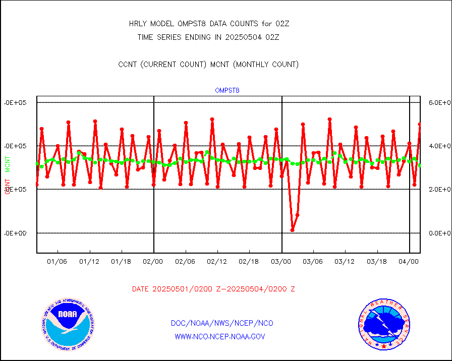
ascat |
METOP 1-2 ASCAT products |
67200 |
44353 |
151.5 % |
2000.50-2001.49 |
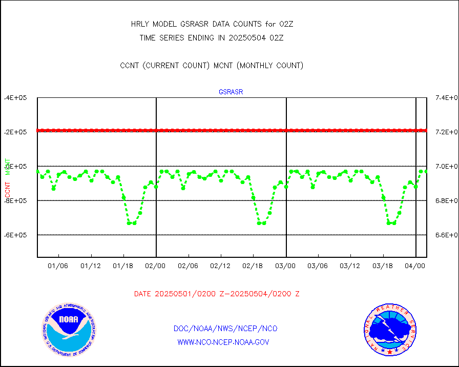
atms |
NPP/NOAA-20 ATMS brightness temperatures |
381504 |
342598 |
111.4 % |
2000.50-2001.49 |
camdar |
Canadian AMDAR aircraft data (decoded from BUFR) |
28 |
15 |
186.7 % |
2001.50-2002.49 |
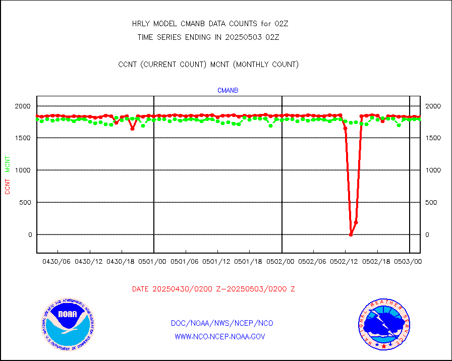
cmanb |
Surface Marine CMAN rpts decoded from BUFR format |
1828 |
1804 |
101.3 % |
2001.50-2002.50 |
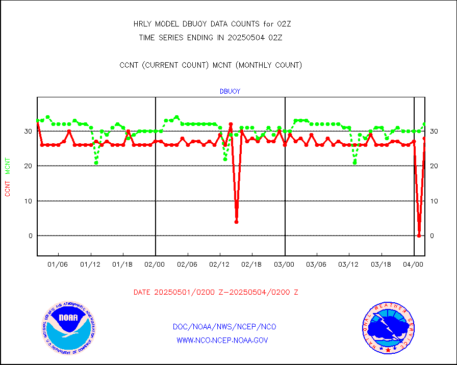
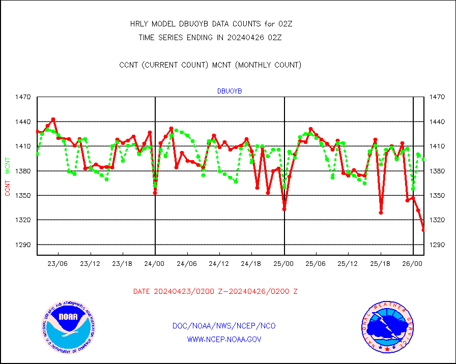
dbuoy |
Buoys decoded from FM-18 fmt (moored or drifting) |
39 |
37 |
105.4 % |
2001.50-2002.49 |
eadas |
E-AMDAR (European AMDAR acft decoded from BUFR) |
523 |
337 |
155.2 % |
2001.50-2002.49 |
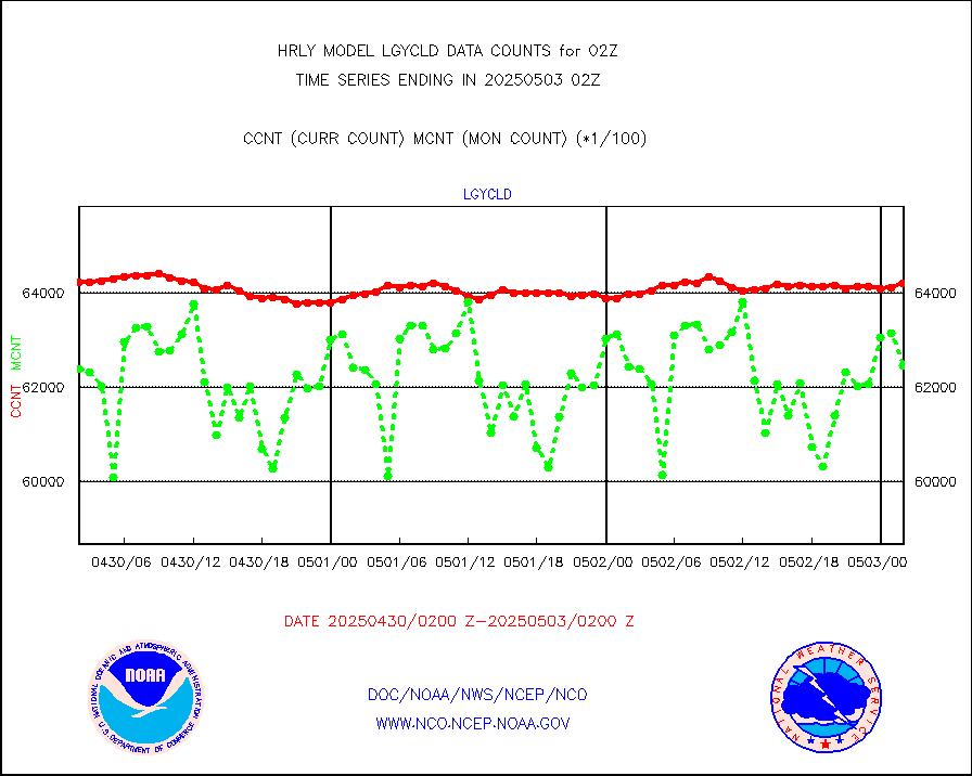
esamua |
NOAA 15-19 & METOP 1-2 AMSU-A proc btmps frm RARS |
44650 |
46239 |
96.6 % |
2001.50-2002.49 |
eshrs3 |
NOAA 15-19 & METOP 1-2 HIRS-3/4 pr btmps frm RARS |
76531 |
87152 |
87.8 % |
2001.50-2002.49 |
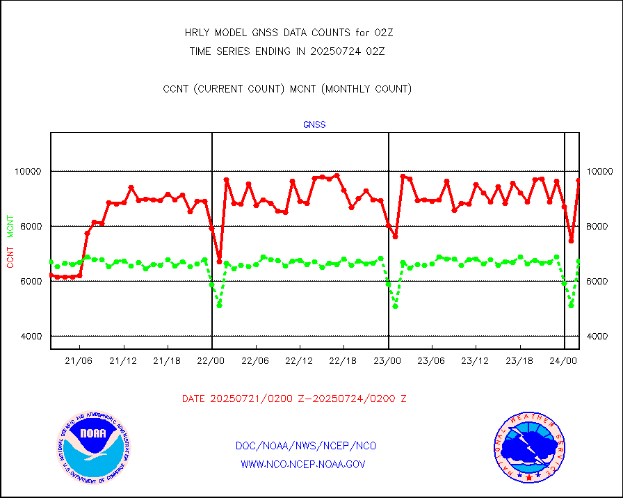
gnss |
Grnd-based Gbl Navigation Sat System (GNSS) data |
9226 |
9052 |
101.9 % |
2001.00-2001.99 |
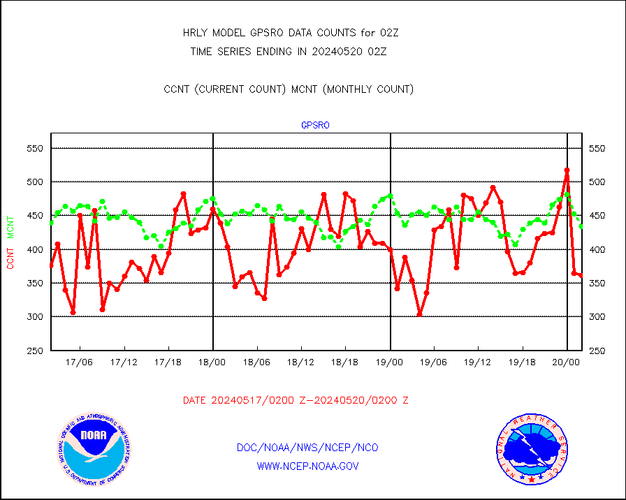
gpsro |
GPS radio occultation data |
361 |
434 |
83.2 % |
1923.50-2000.49 |
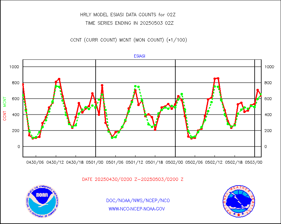
gsrasr |
GOES-16/17 All Sky Radiances (proc.) |
360476 |
348404 |
103.5 % |
2001.50-2002.49 |
gsrcsr |
GOES-16/17 Clear Sky Radiances (proc.) |
163378 |
170056 |
96.1 % |
2001.50-2002.49 |
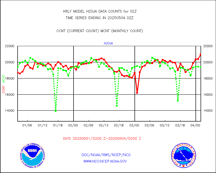
h20ja |
MTSAT/JMA water vapor imager derived cloud motion |
18590 |
18786 |
99.0 % |
1923.50-2000.49 |
h20mo |
MODIS (AQUA/TERRA) wvpr imager derived cld motion |
0 |
0 |
n/a |
1922.00-1922.99 |
h2tusr |
GOES-16&up/NESDIS wv imgr/cld-top derived cld mtn |
28208 |
28553 |
98.8 % |
2001.00-2001.99 |
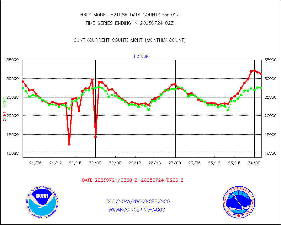
ifeunb |
METEOSAT/EUMETSAT ir lg-wave drv cld motion NBseq |
20993 |
21323 |
98.5 % |
2000.50-2001.49 |
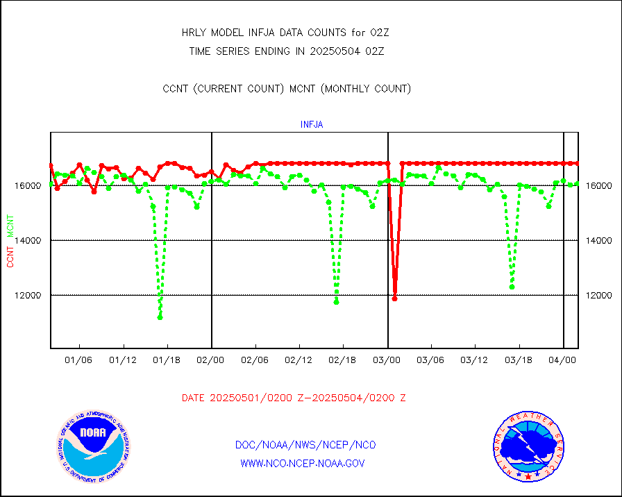
infja |
MTSAT/JMA infrared long-wave derived cloud motion |
14740 |
15963 |
92.3 % |
1923.50-2000.49 |
infmo |
MODIS (AQUA/TERRA) ir l-wave derived cloud motion |
0 |
0 |
n/a |
1922.00-1922.99 |
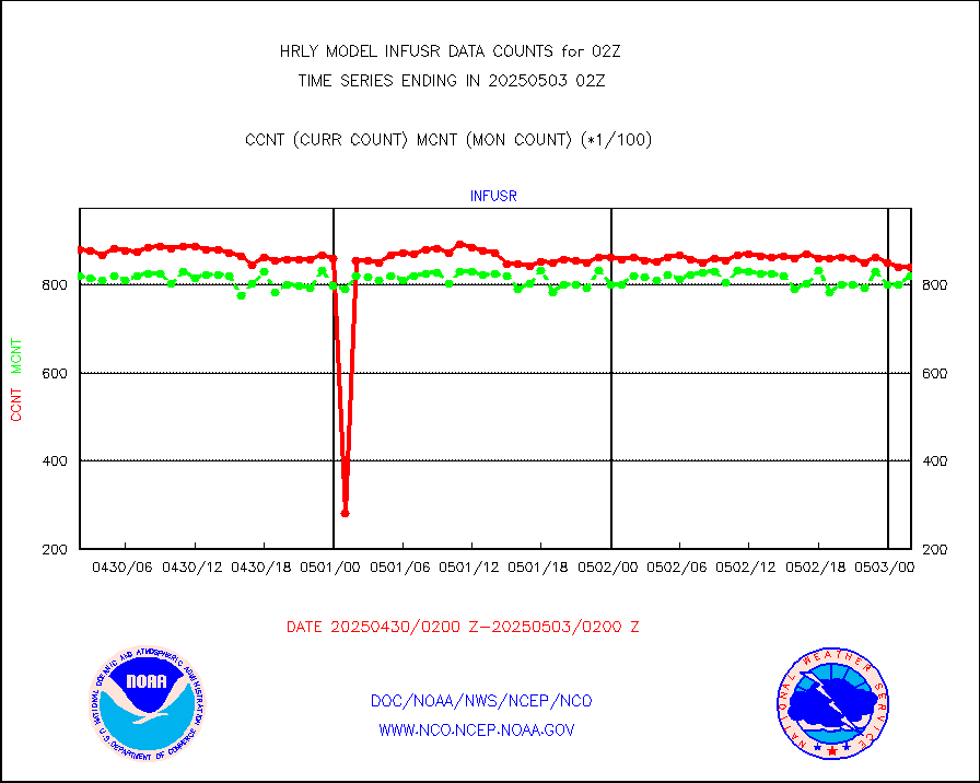
infusr |
GOES-16&up/NESDIS ir long-wave derived cld motion |
75704 |
79926 |
94.7 % |
2001.00-2001.99 |
lgycld |
GOES/NASA(Langley) hi-res. (1x1 f-o-v) cloud data |
4211670 |
3607169 |
116.8 % |
2001.50-2002.49 |
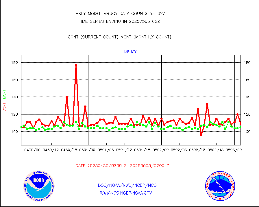
mbuoy |
Buoys decoded from FM-13 format (moored) |
118 |
113 |
104.4 % |
2001.50-2002.49 |
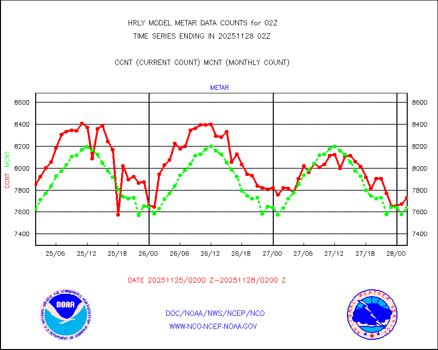
metar |
Aviation - METAR |
7292 |
7563 |
96.4 % |
2001.50-2002.49 |
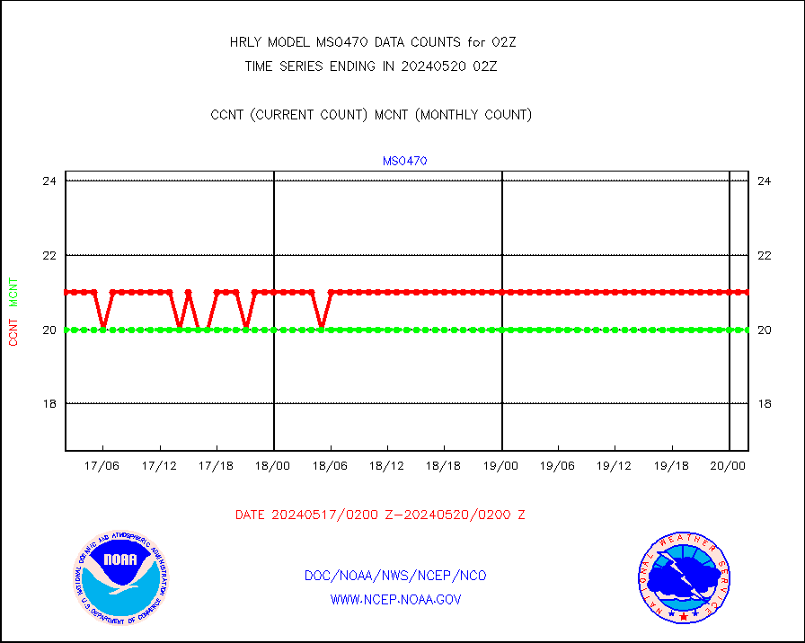
mso470 |
Mesonet/MADIS Colorado E-470 (Interstate 470) |
21 |
20 |
105.0 % |
2001.50-2002.49 |
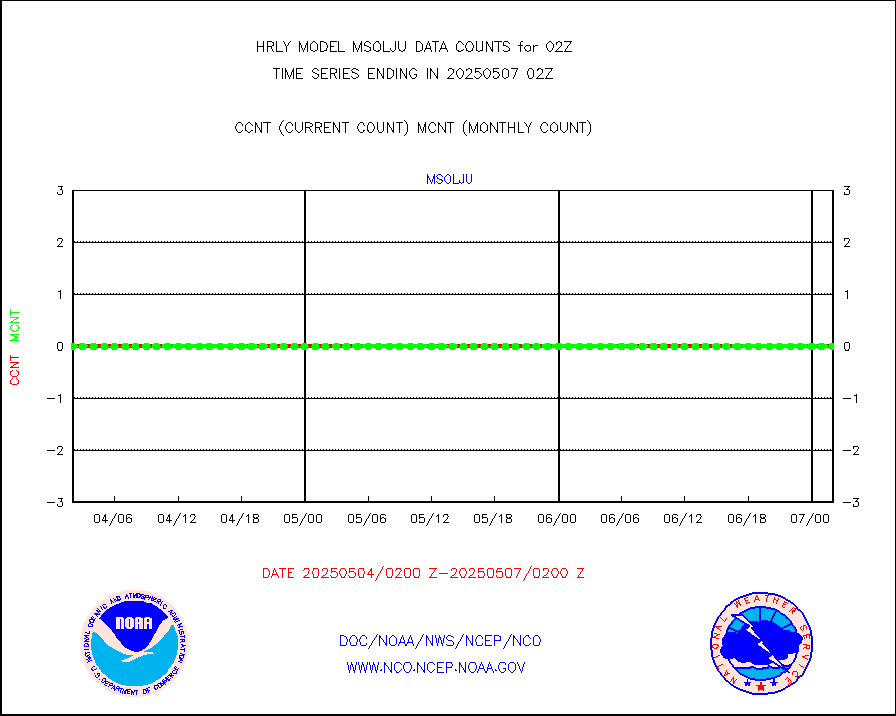
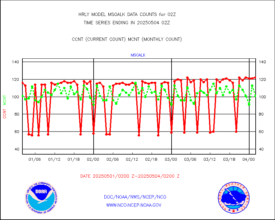
msoalk |
Mesonet/MADIS Alaska Department of Transportation |
107 |
108 |
99.1 % |
2001.50-2002.49 |
msoapg |
Mesonet/MADIS U.S. Army Aberdeen Proving Grounds |
0 |
0 |
n/a |
2001.50-2002.49 |
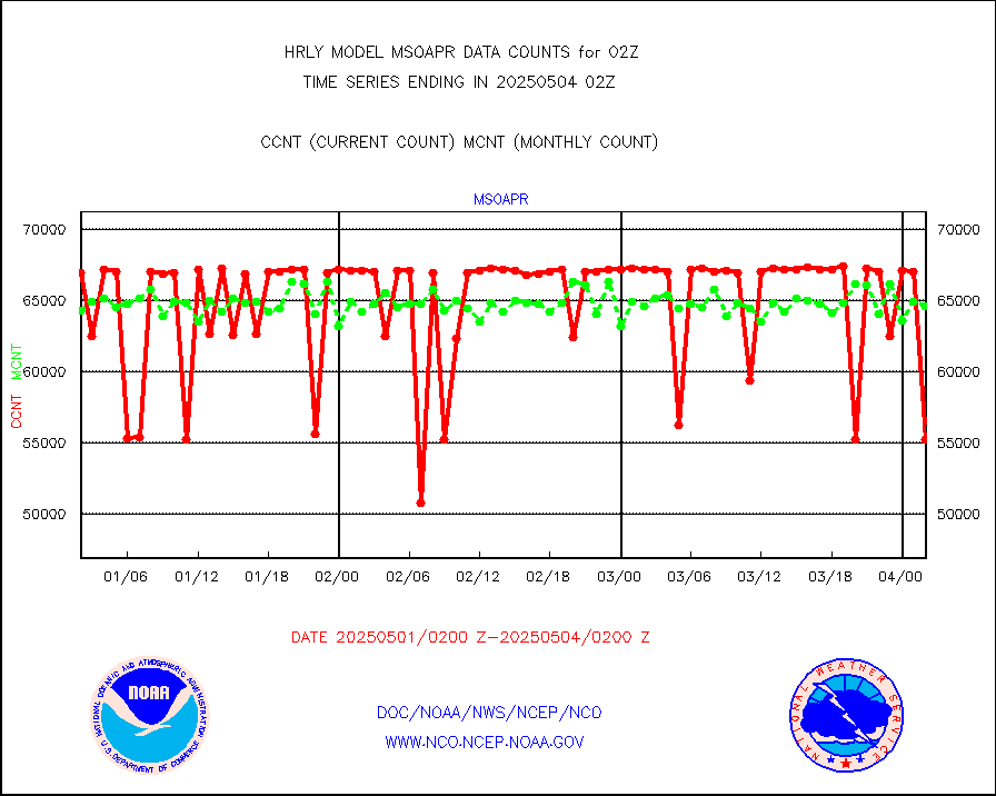
msoapr |
Mesonet/MADIS Citizen Weather Observers Program |
49692 |
48382 |
102.7 % |
2001.50-2002.49 |
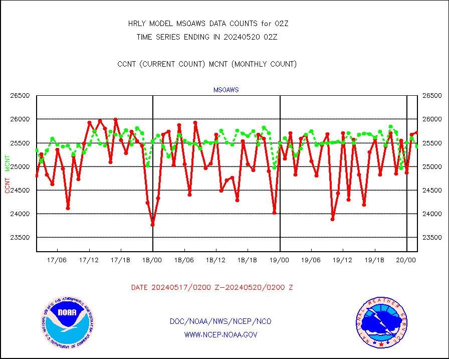
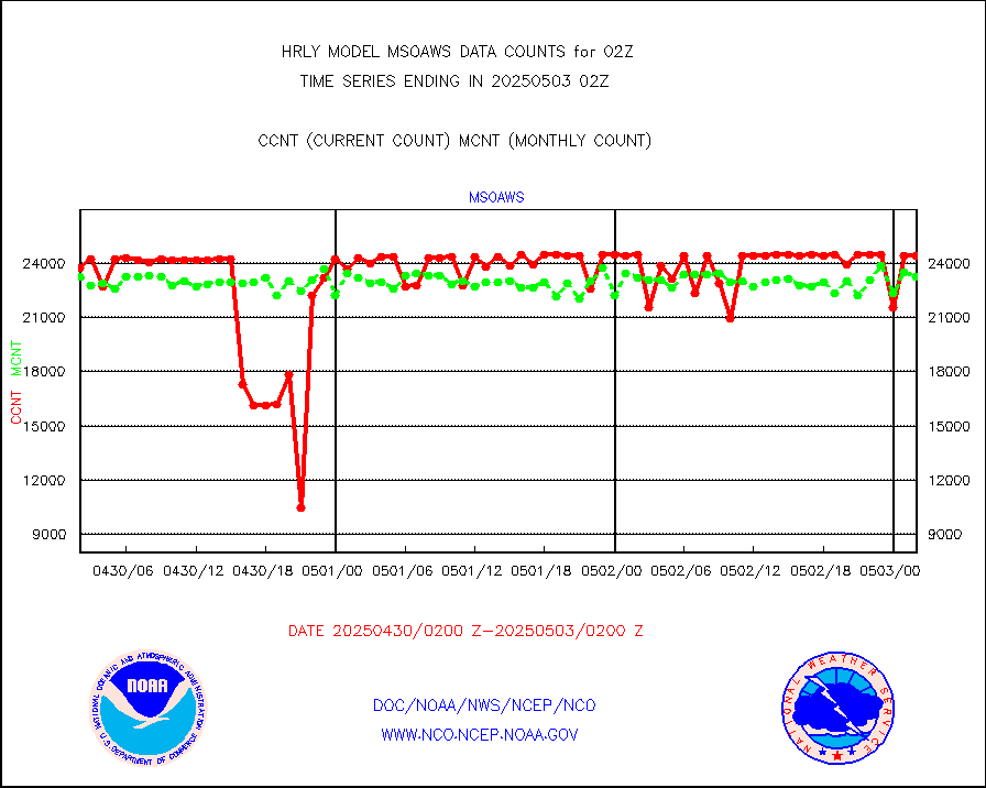
msoaws |
Mesonet/MADIS AWS Convergence Technologies, Inc. |
25724 |
25424 |
101.2 % |
2001.50-2002.49 |
msoawx |
Mesonet/MADIS "Anything Weather" |
0 |
0 |
n/a |
2001.50-2002.49 |
msocol |
Mesonet/MADIS Colorado Dept. of Transportation |
0 |
0 |
n/a |
2001.50-2002.49 |
msodcn |
Mesonet/MADIS DC Net |
0 |
0 |
n/a |
2001.50-2002.49 |
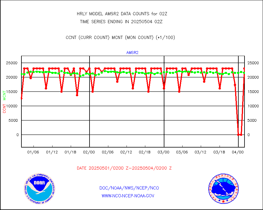
msoden |
Mesonet/MADIS Denver Urban Drainage & Flood Cntrl |
250 |
248 |
100.8 % |
2001.50-2002.49 |
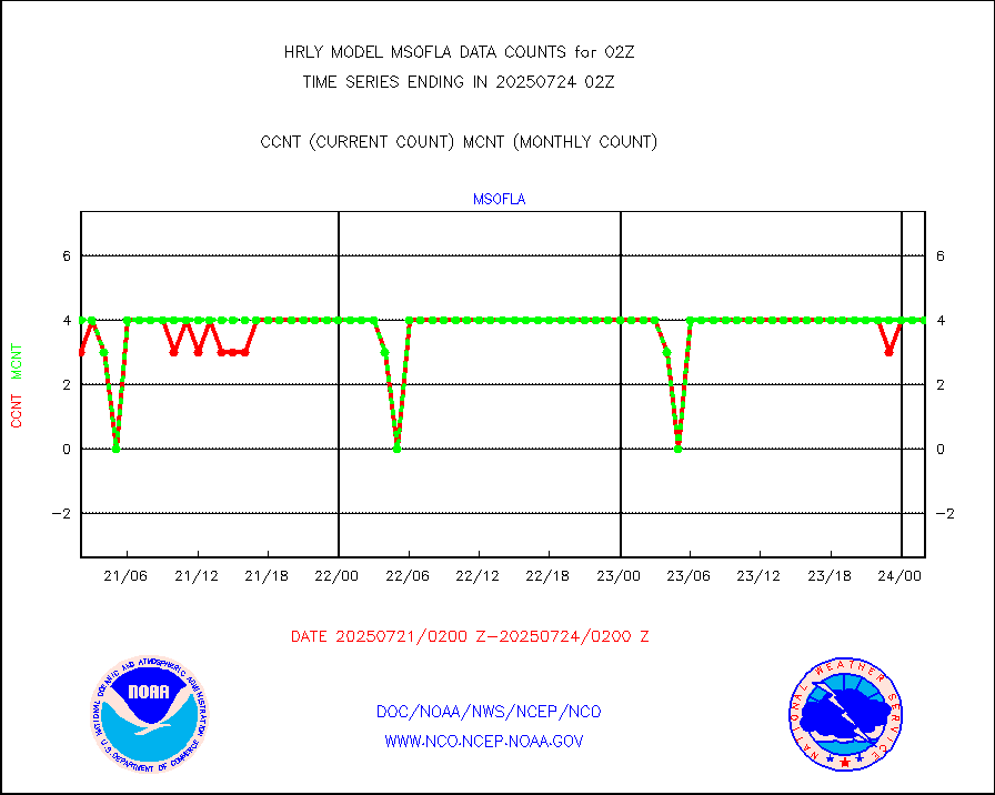
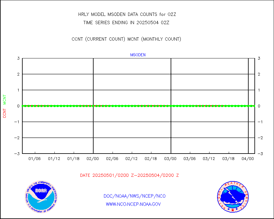
msofla |
Mesonet/MADIS Florida (FAWN & USF) |
4 |
4 |
100.0 % |
2001.50-2002.49 |
msoflt |
Mesonet/MADIS Florida Dept. of Transportation |
0 |
0 |
n/a |
2001.50-2002.49 |
msogeo |
Mesonet/MADIS Georgia Dept. of Transportation |
0 |
0 |
n/a |
2001.50-2002.49 |
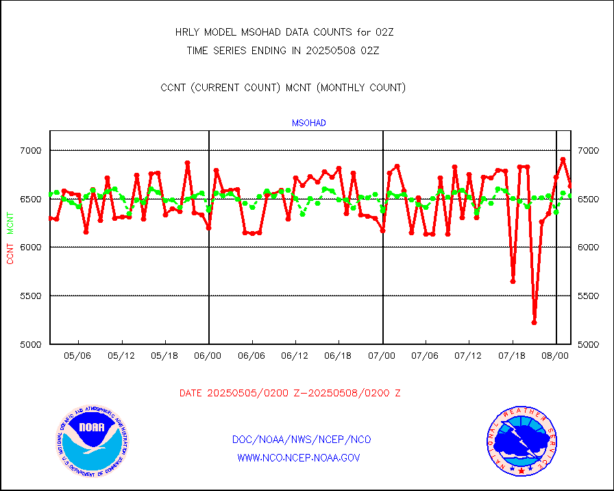
msohad |
Mesonet/MADIS NWS Hydromet Auto Data System(HADS) |
6850 |
6771 |
101.2 % |
2001.50-2002.49 |
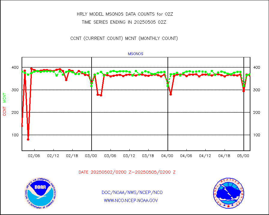
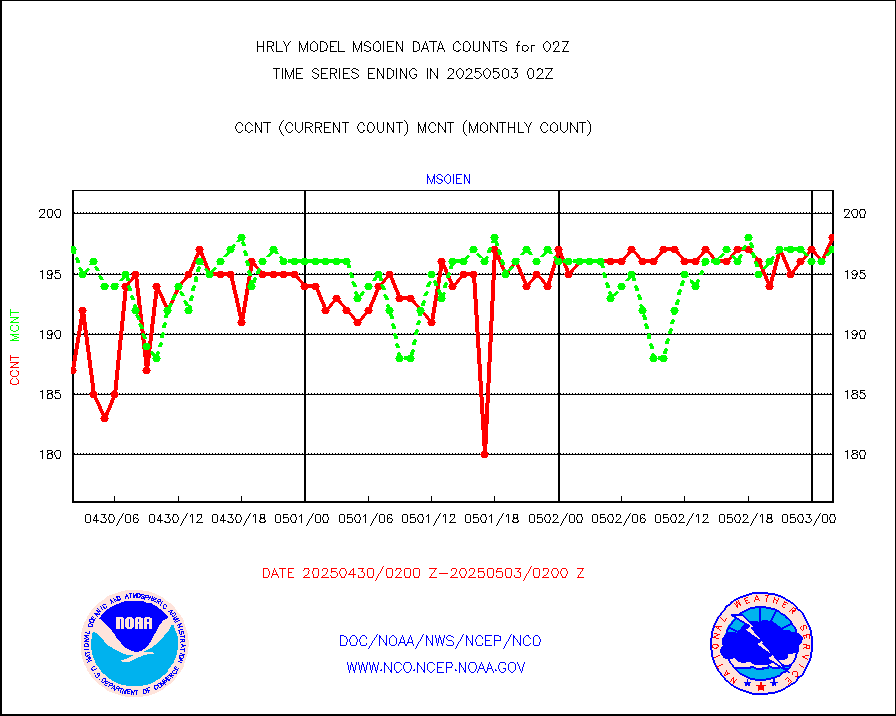
msoien |
Mesonet/MADIS Iowa Environmental |
181 |
187 |
96.8 % |
2001.50-2002.49 |
msoind |
Mesonet/MADIS Indiana Dept. of Transportation |
0 |
0 |
n/a |
2001.50-2002.49 |
msoiow |
Mesonet/MADIS Iowa Department of Transportation |
0 |
0 |
n/a |
2001.50-2002.49 |
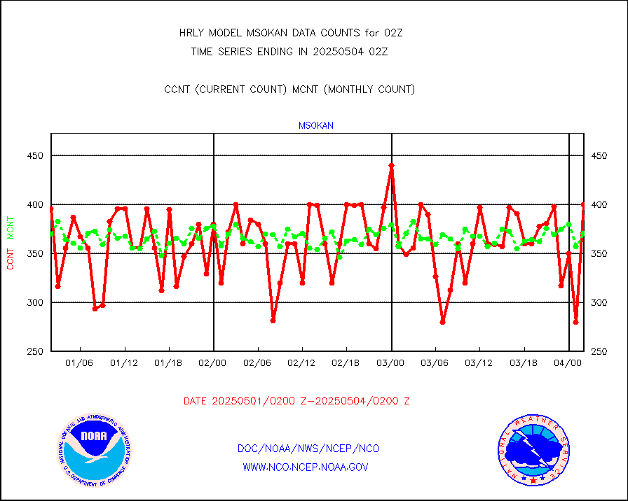
msokan |
Mesonet/MADIS Kansas Department of Transportation |
361 |
353 |
102.3 % |
2001.50-2002.49 |
msokla |
Mesonet/MADIS Oklahoma Mesonet |
318 |
314 |
101.3 % |
2001.50-2002.49 |
msolju |
Mesonet/MADIS Louisiana State/Jackson State Univ. |
0 |
0 |
n/a |
2001.50-2002.49 |
msomca |
Mesonet/MADIS Missouri Commercial Agricult Wx Net |
302 |
296 |
102.0 % |
2001.50-2002.49 |
msomin |
Mesonet/MADIS Minnesota Dept. of Transportation |
0 |
0 |
n/a |
2001.50-2002.49 |
msonos |
Mesonet/MADIS NOS-Phys Oceanographic Realtime Sys |
387 |
381 |
101.6 % |
2001.50-2002.49 |
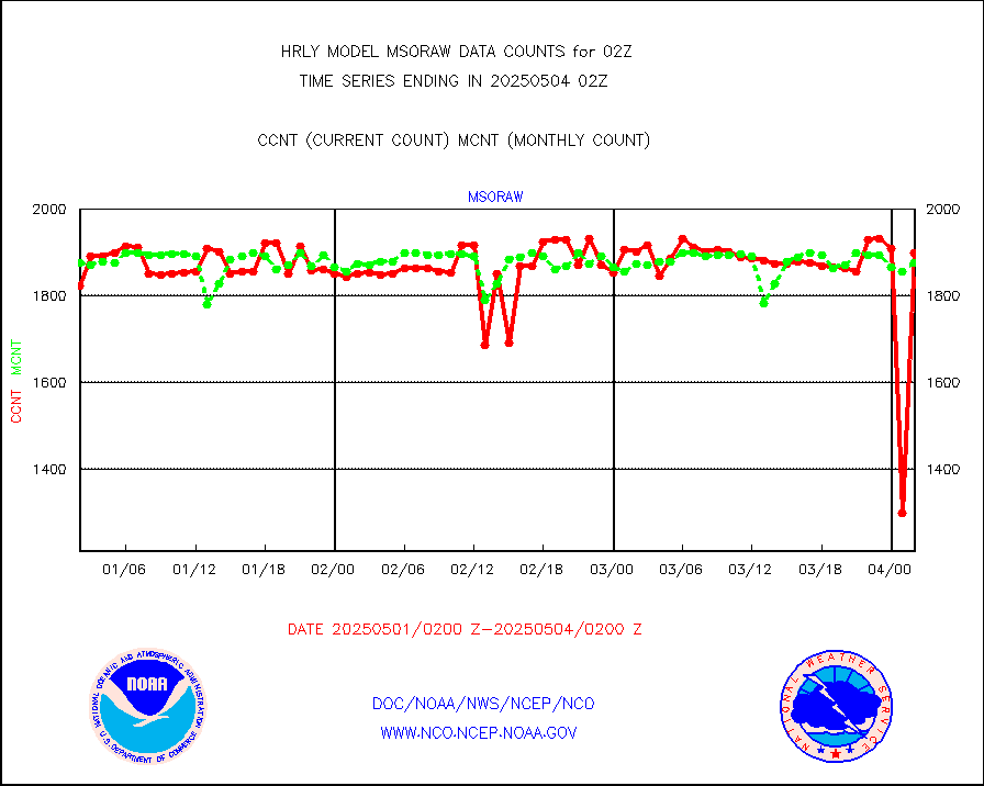
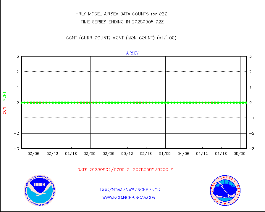
msoraw |
Mesonet/MADIS NFIC Remote Automated Wx Stns(RAWS) |
1925 |
1866 |
103.2 % |
2001.50-2002.49 |
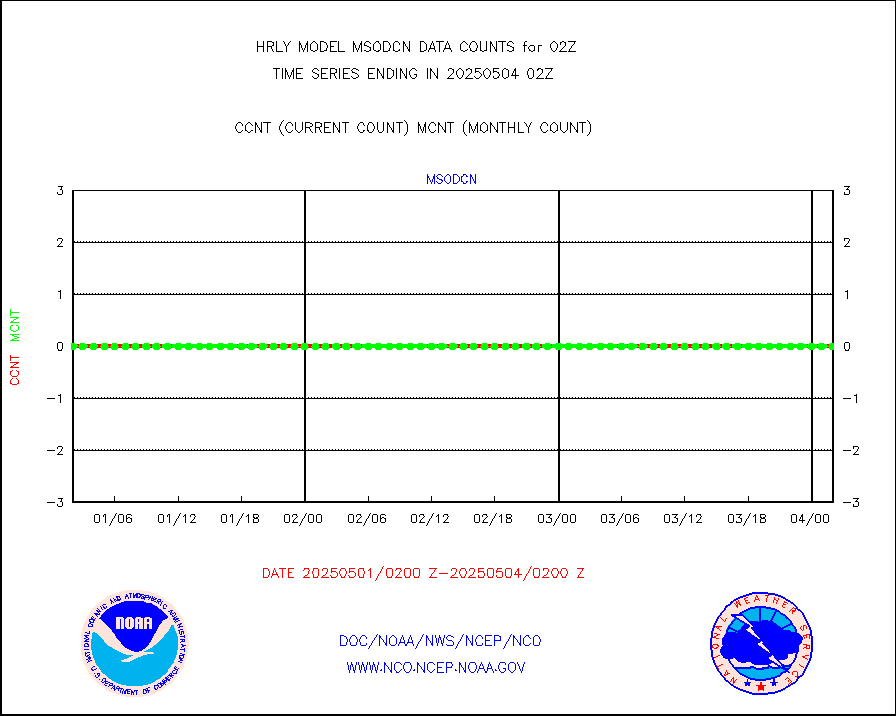
msovir |
Mesonet/MADIS Virginia Dept. of Transportation |
206 |
227 |
90.7 % |
2001.50-2002.49 |
msowfy |
Mesonet/MADIS "Weather for You" |
0 |
0 |
n/a |
2001.50-2002.49 |
msowis |
Mesonet/MADIS Wisconsin Dept. of Transportation |
0 |
0 |
n/a |
2001.50-2002.49 |
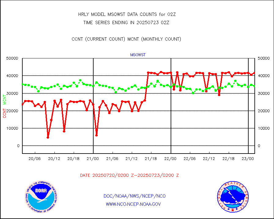
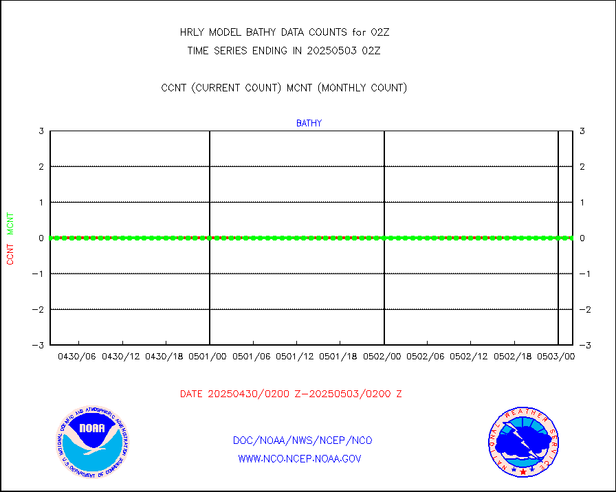
msowst |
Mesonet/MADIS MesoWest (many subproviders) |
47460 |
45880 |
103.4 % |
2001.50-2002.49 |
msowtx |
Mesonet/MADIS West Texas |
5643 |
5598 |
100.8 % |
2001.50-2002.49 |
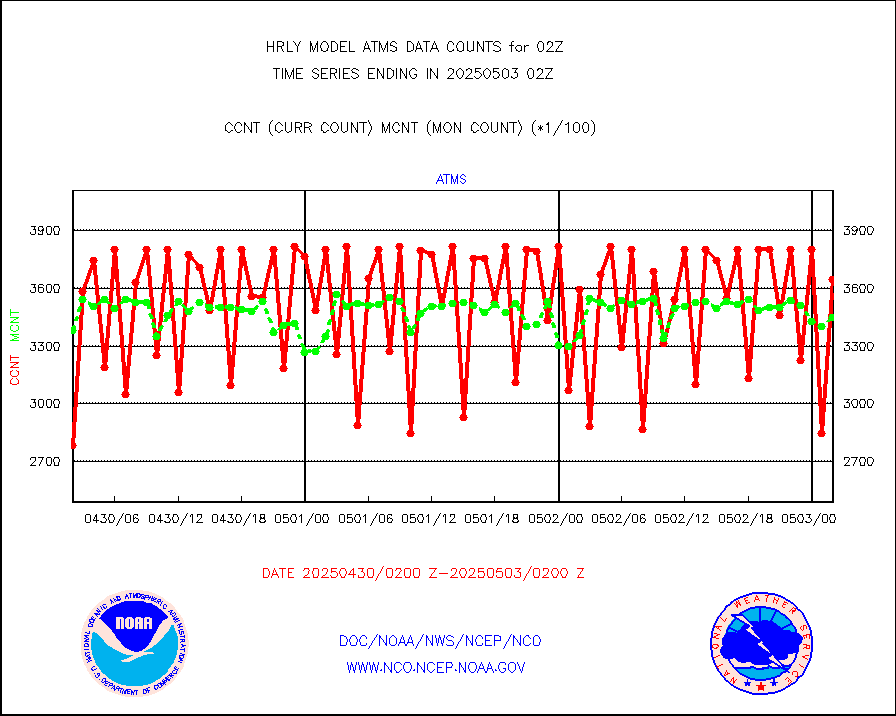
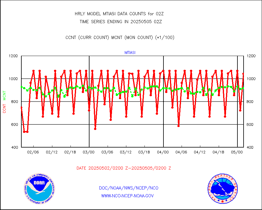
mtiasi |
METOP 1-2 IASI 1C radiance data (varbl. channels) |
56052 |
82807 |
67.7 % |
2000.00-2000.99 |
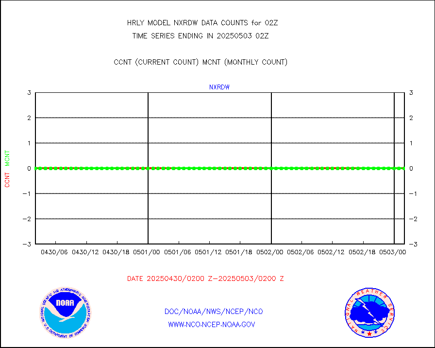
nxrdw |
NEXRAD Vel Azm Dsp(VAD) winds via radar coded msg |
0 |
0 |
n/a |
2001.50-2002.49 |
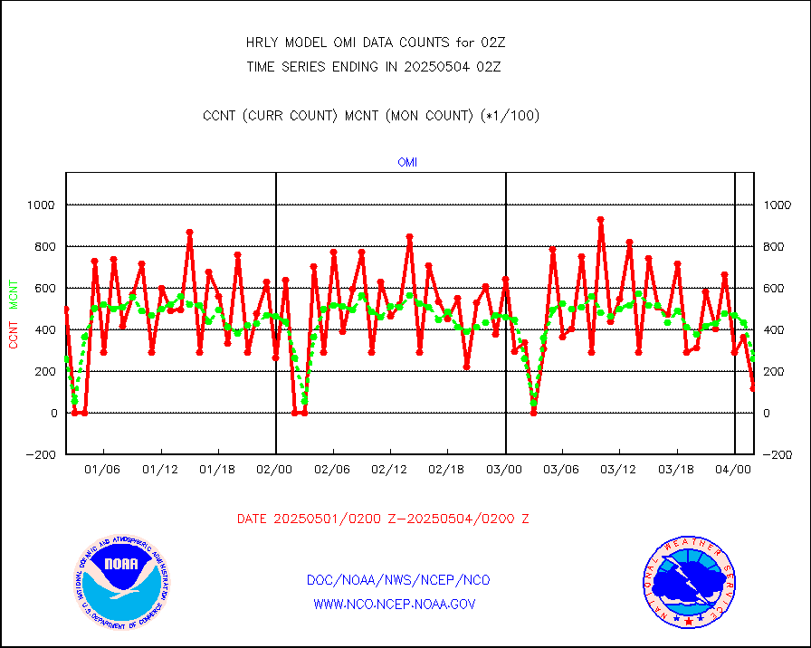
omi |
Aura Ozone Monitoring Instrument (OMI) data |
3300 |
14262 |
23.1 % |
1923.50-2000.49 |
osbuv8 |
NOAA 16-19 Solar Backscatter UV-2 rad frm V8 BUFR |
0 |
0 |
n/a |
2000.00-2000.99 |
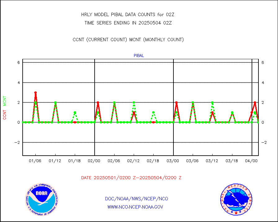
pibal |
PIBAL (from PILOT, PILOT SHIP, PILOT MOBIL) |
0 |
0 |
n/a |
2001.50-2002.49 |
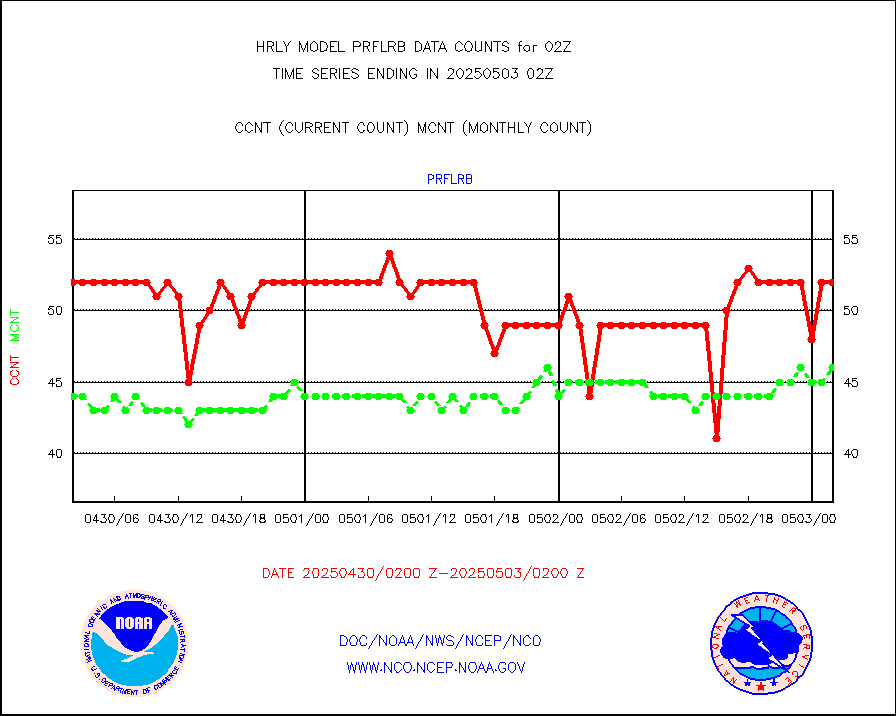
prflrb |
Multi-Agency Profiler (MAP) and SODAR winds |
34 |
41 |
82.9 % |
2001.50-2002.49 |
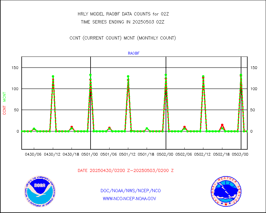
raobf |
Rawinsonde - fixed land (from TEMP or PILOT) |
0 |
0 |
n/a |
2001.50-2002.49 |
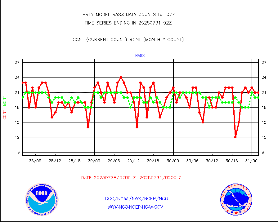
rass |
RASS temperatures (NOAA and Multi-Agency) |
22 |
26 |
84.6 % |
2001.50-2002.49 |
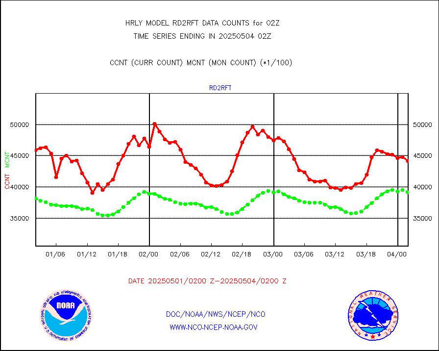
rd2rft |
NEXRAD reflectivity (Lvl 2 - GTS) |
4235429 |
4114791 |
102.9 % |
2001.50-2002.49 |
rd2wnd |
NEXRAD radial wind (Level 2 - GTS) |
1668037 |
1580960 |
105.5 % |
2001.50-2002.49 |
sevcsr |
METEOSAT-10 2nd Gen SEVIRI Clr Sky Radiance(proc) |
0 |
0 |
n/a |
2001.50-2002.49 |
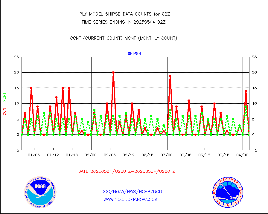
shipsb |
Ship - manual and automatic, restricted (BUFR) |
0 |
0 |
n/a |
2001.50-2002.50 |
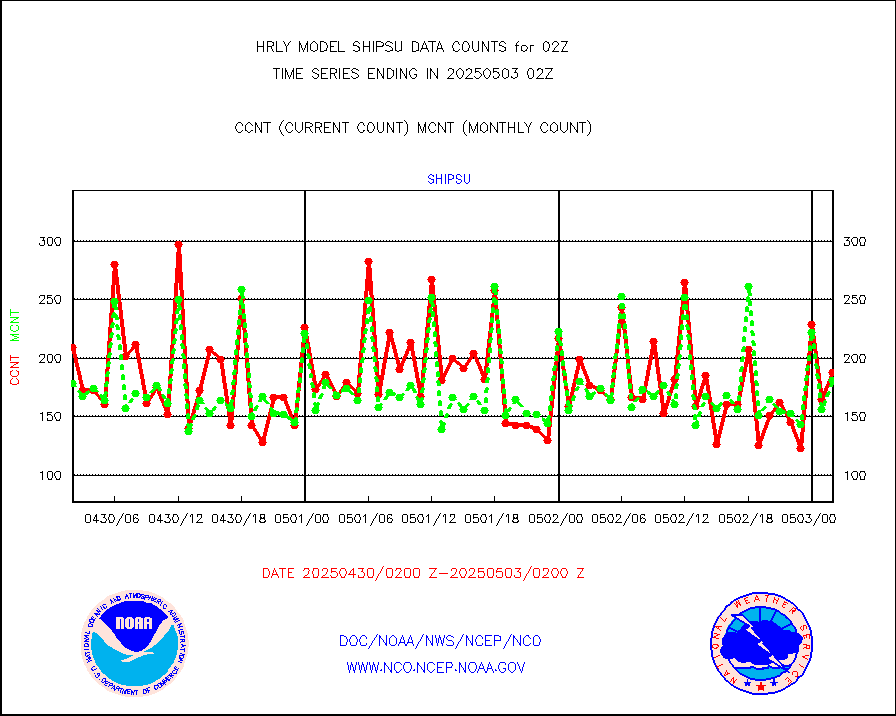
shipsu |
Ship - manual and automatic, unrestricted |
132 |
123 |
107.3 % |
2001.50-2002.50 |
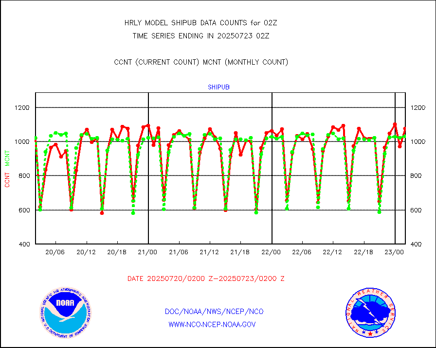
shipub |
Ship - manual and automatic, unrestricted (BUFR) |
856 |
830 |
103.1 % |
2001.50-2002.50 |
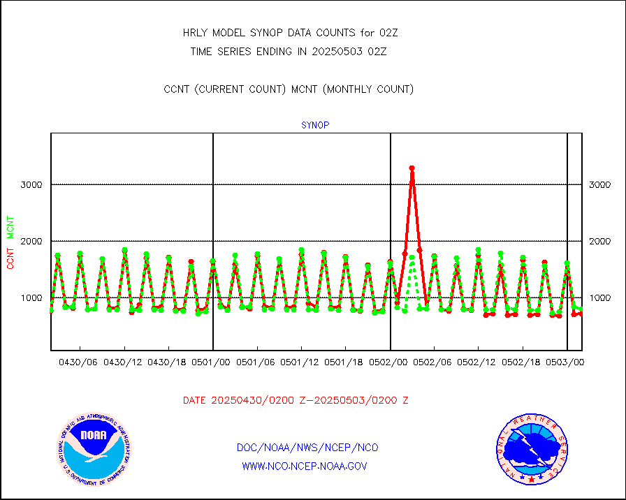
synop |
Synoptic - fixed manual and automatic |
910 |
856 |
106.3 % |
2001.50-2002.49 |
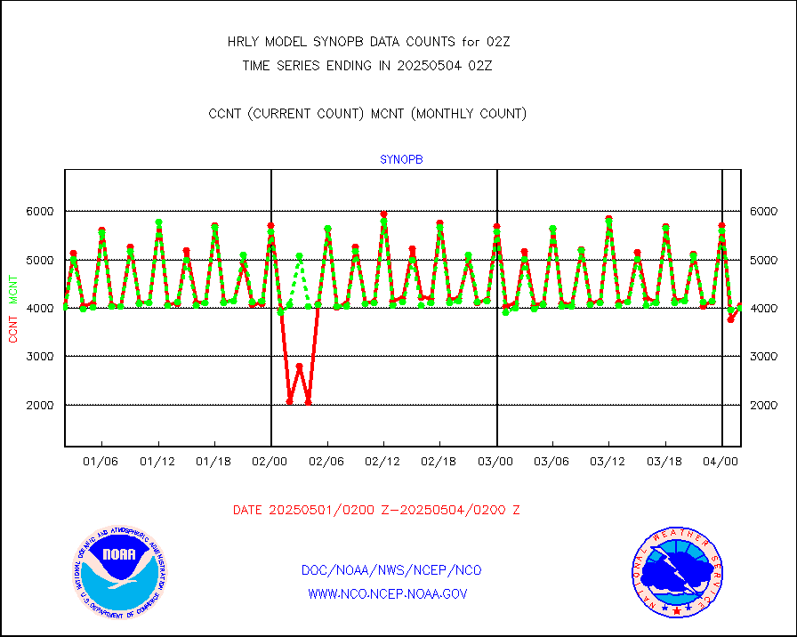
synopb |
Synoptic - fixed manual & auto (decoded fr BUFR) |
4108 |
4136 |
99.3 % |
2001.50-2002.49 |
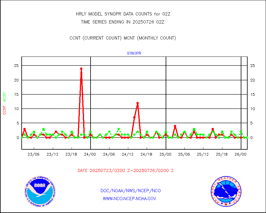
synopr |
Synoptic - restricted (WMO Res 40) manual & auto. |
0 |
0 |
n/a |
2001.50-2002.49 |
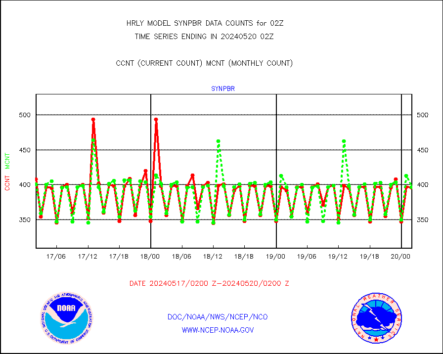
synpbr |
Synoptic - restricted (WMO Res 40)(decoded BUFR) |
396 |
397 |
99.7 % |
2001.50-2002.49 |
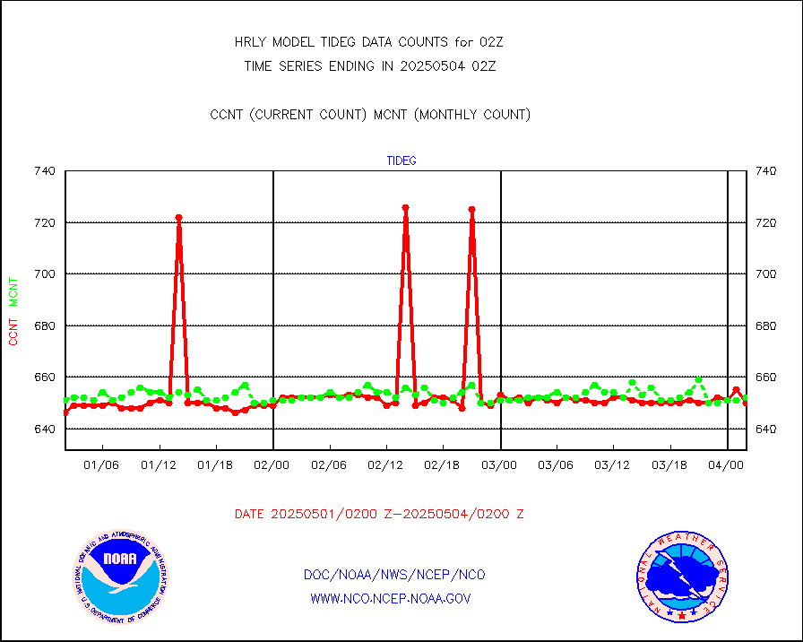
tideg |
Tide gauge reports decoded from CREX format |
645 |
641 |
100.6 % |
2001.00-2001.99 |
| Data Types of Opportunity with Normal Counts |
|---|
| Type | Description | Hourly Count | Monthly Average | Percent (%) of Monthly Mean | UTC Time Window |
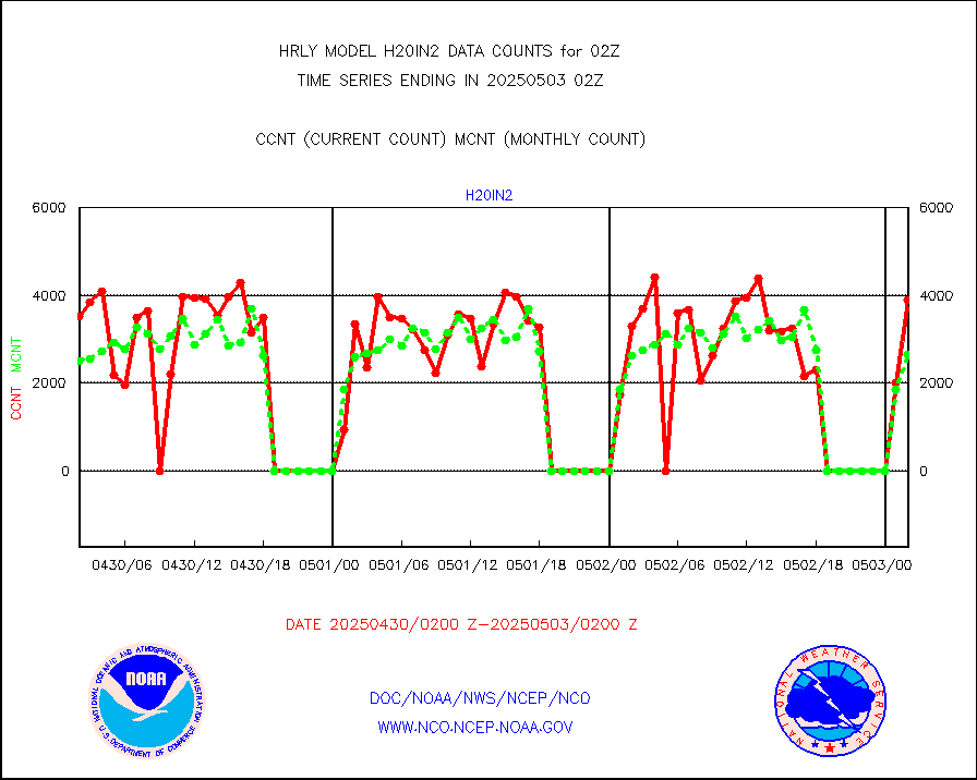
3p9usr |
GOES-16&up/NESDIS ir short-wv derived cld motion |
18845 |
21125 |
89.2 % |
2001.00-2001.99 |
acarsa |
MDCRS ACARS acft data (ARINC via AFWA)(AIREP fmt) |
0 |
0 |
n/a |
2001.50-2002.49 |
ahicsr |
Himawari Clear Sky Radiance |
0 |
0 |
n/a |
2001.00-2001.99 |
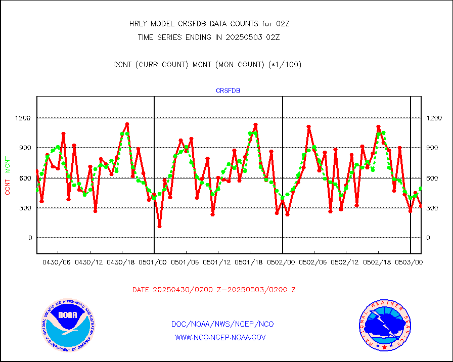
amsr2 |
GCOM-W AMSR2 1B brightness temperatures |
2309472 |
2117146 |
109.1 % |
2000.00-2000.99 |
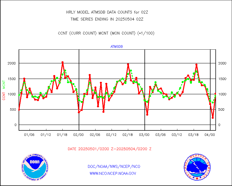
atmsdb |
NPP/NOAA-20 ATMS bright. temps-direct b-cast SSEC |
82268 |
83832 |
98.1 % |
2000.50-2001.49 |
atovs |
POES/NESDIS - processed ATOVS soundings/radiances |
0 |
0 |
n/a |
2000.00-2000.99 |
avcsam |
A.M.(N17,M2,M3) AVHRR GAC NCEP-proc clr&sea btmps |
1525525 |
1372827 |
111.1 % |
1923.50-2000.49 |
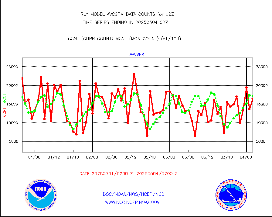
avcspm |
P.M.(N18-19) AVHRR GAC NCEP-proc clr & sea btemps |
1507630 |
1587083 |
95.0 % |
1923.50-2000.49 |
bathy |
eXpendable BathyThermograph, mooring (BATHY fmt) |
0 |
0 |
n/a |
1919.00-1919.99 |
coopmd |
Coop/MADIS NEPP & HCN-Modernization NOAA COOP Obs |
27 |
27 |
100.0 % |
2001.50-2002.49 |
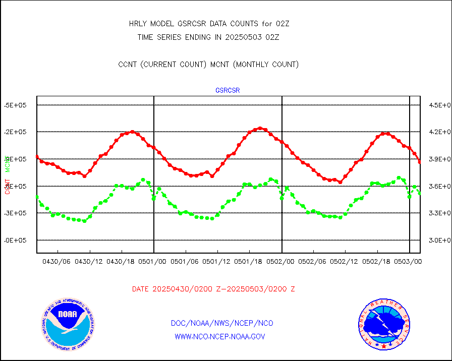
crisf4 |
NPP/NOAA-20 CrIS full spctrl radn (431 ch subset) |
240534 |
229550 |
104.8 % |
2000.50-2001.49 |
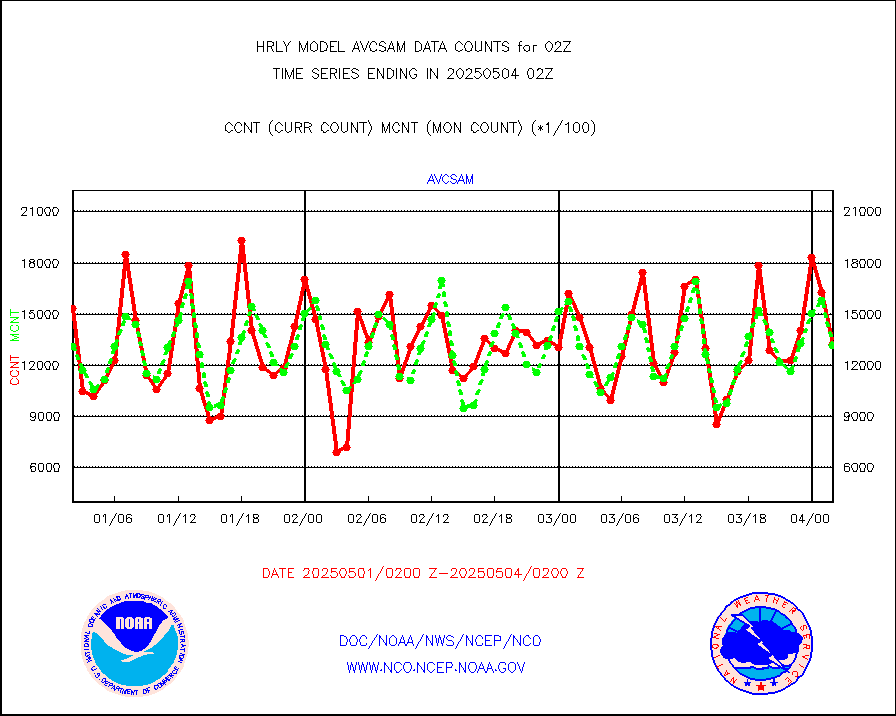
crsfdb |
NPP/NOAA-20 CrIS full spctrl radn dir brdcst SSEC |
61992 |
84974 |
73.0 % |
2000.50-2001.49 |
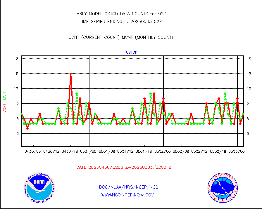
cstgd |
Coast Guard |
6 |
5 |
120.0 % |
2001.50-2002.50 |
dbuoyb |
Drifting buoys (decoded from BUFR) |
1399 |
1382 |
101.2 % |
2001.50-2002.50 |
dropw |
Dropwinsonde (from TEMP DROP) |
0 |
0 |
n/a |
2001.50-2002.49 |
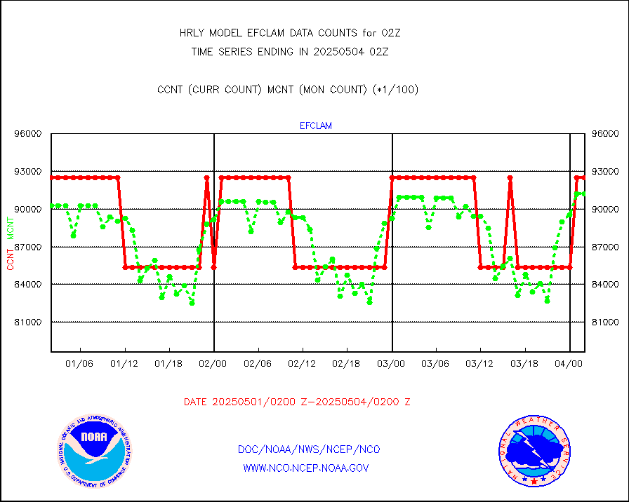
efclam |
GOES imager effective cloud amount data (U.Wisc.) |
8297774 |
8234165 |
100.8 % |
2001.50-2002.49 |
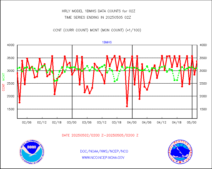
esatms |
NPP Adv. Tech. MW Sndr (ATMS) br. temps from RARS |
62190 |
86665 |
71.8 % |
2000.50-2001.49 |
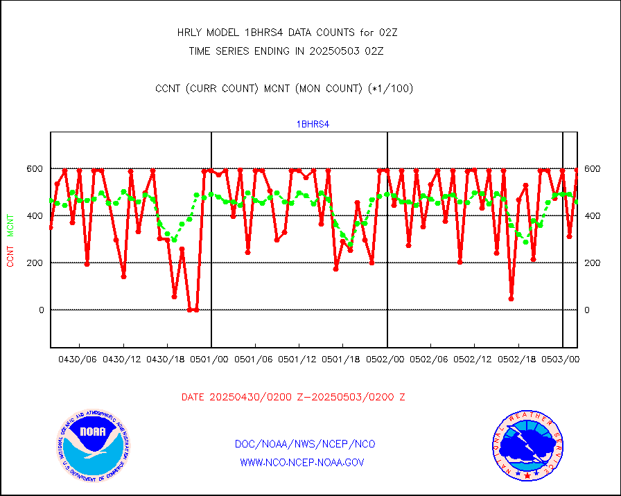
esiasi |
METOP 1-2 IASI 1C radiance data vbl chn from RARS |
79221 |
88600 |
89.4 % |
2001.00-2001.99 |
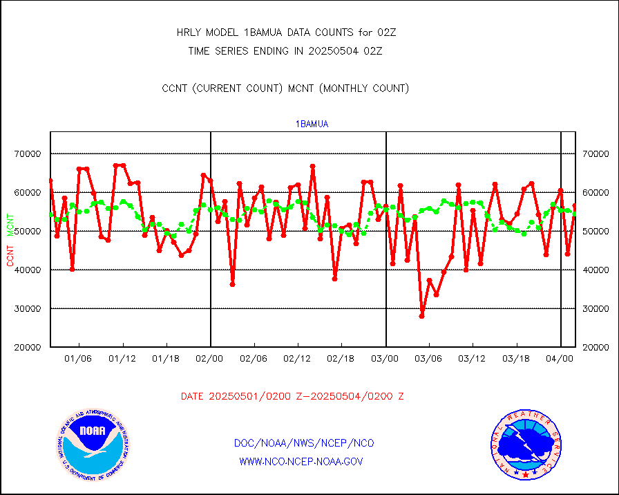
esmhs |
NOAA 18-19 & METOP 1-2 MHS proc. btemps from RARS |
286014 |
374053 |
76.5 % |
2001.50-2002.49 |
geoimr |
GOES/NESDIS (11x17 f-o-v) imager clear radiances |
0 |
0 |
n/a |
2001.00-2001.99 |
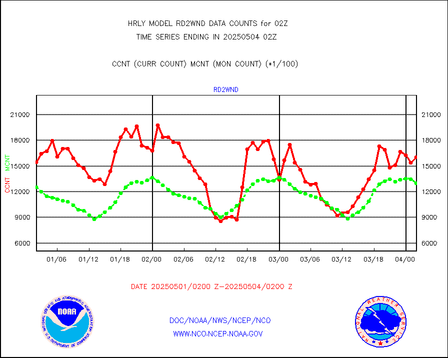
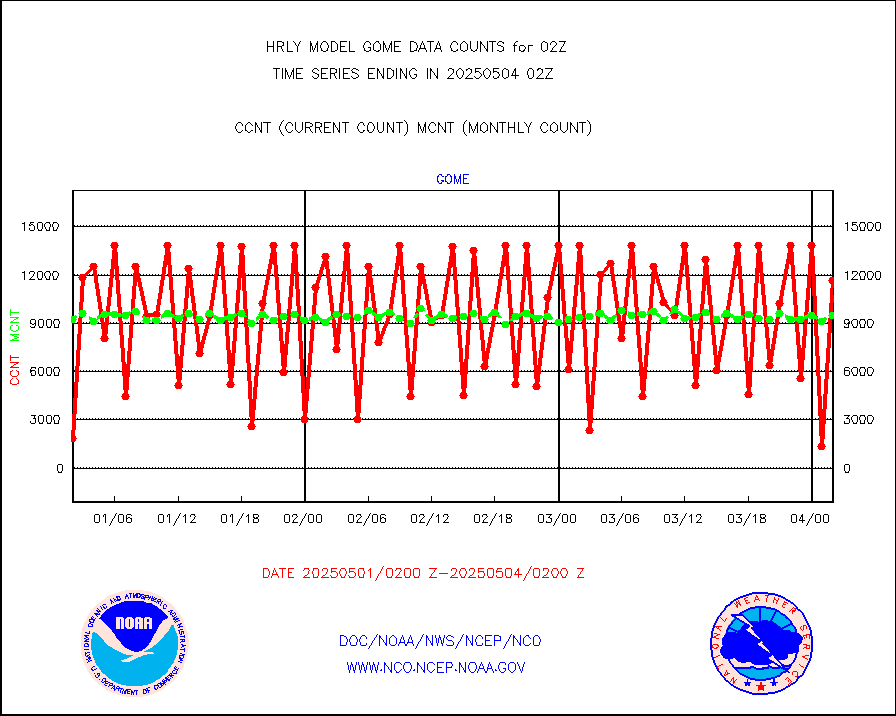
gome |
METOP 1-2 Global Ozone Monitoring Exp.-2 (GOME-2) |
14252 |
6933 |
205.6 % |
2000.50-2001.49 |
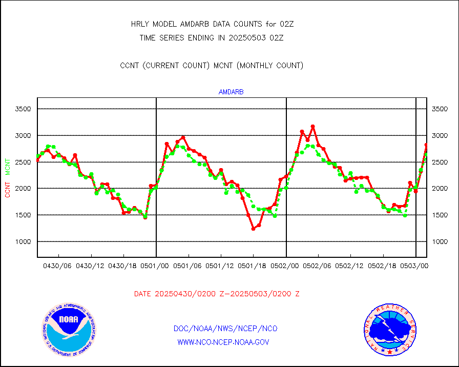
h20in2 |
INDIA SATWIND, INSAT WV channel |
6602 |
4722 |
139.8 % |
2001.00-2001.99 |
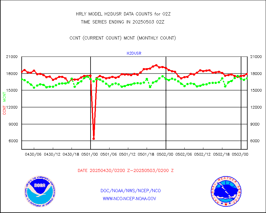
h2dusr |
GOES-16&up/NESDIS wv imgr/deep-lyr derivd cld mtn |
15603 |
16621 |
93.9 % |
2001.00-2001.99 |
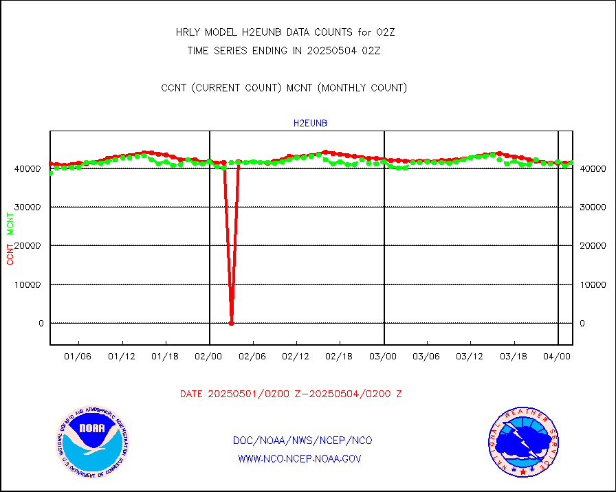
h2eunb |
METEOSAT/EUMETSAT wvpr imgr drv cld motion NBseq |
38368 |
40761 |
94.1 % |
2000.50-2001.49 |
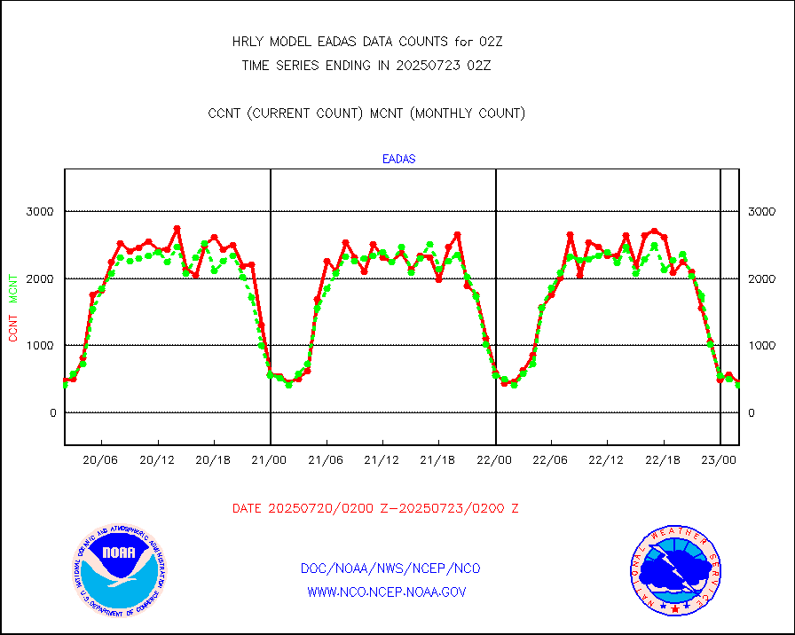
hdob |
High Density OBs from reconnaissance acft data |
0 |
2 |
0.0 % |
2001.50-2002.49 |
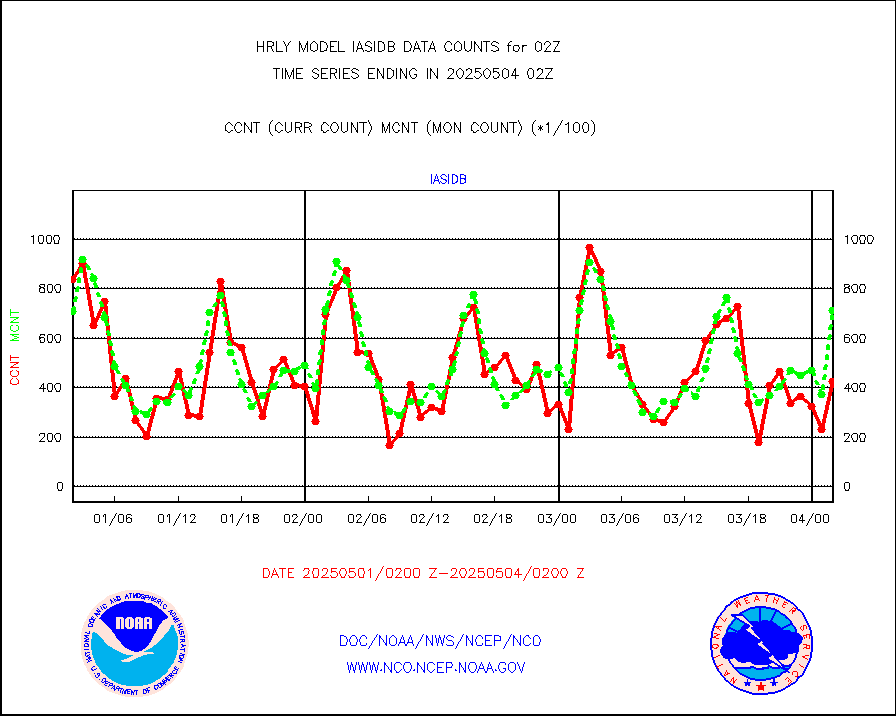
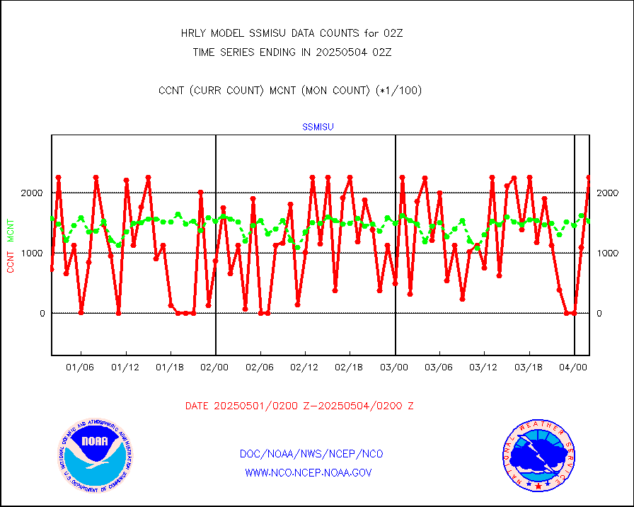
iasidb |
METOP 1-2 IASI 1C radiances-direct broadcast SSEC |
54370 |
47754 |
113.9 % |
2000.50-2001.49 |
ifvrnb |
VIIRS (NPP/NOAA-20) ir lg-wv drv cloud motion(NB) |
26102 |
16544 |
157.8 % |
1922.00-1922.99 |
infav |
AVHRR (NOAA/METOP) ir lg-wave derived cld motion |
0 |
0 |
n/a |
1922.00-1922.99 |
infav1 |
AVHRR (METOP) ir lg-wave derived cld motion |
0 |
0 |
n/a |
2001.50-2002.50 |
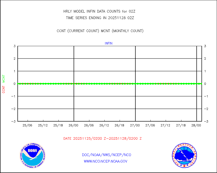
infin |
INSAT/KALPANA India ir lg-wave derived cld motion |
0 |
0 |
n/a |
1923.50-2000.49 |
infin2 |
INDIA SATWIND, INSAT IR channel |
8863 |
4821 |
183.8 % |
2001.00-2001.99 |
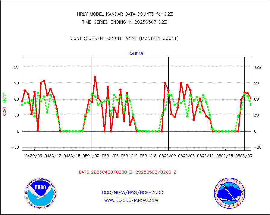
kamdar |
Korean AMDAR aircraft data (decoded from BUFR) |
32 |
49 |
65.3 % |
2001.50-2002.49 |
lcman |
Land-based CMAN stations decoded from CMAN format |
90 |
79 |
113.9 % |
2001.50-2002.49 |
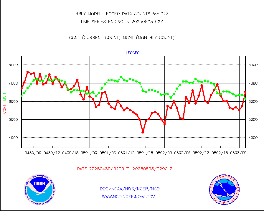
leogeo |
LEO-GEO satellite AMVs from UWisc. |
6497 |
5011 |
129.7 % |
1922.00-1922.99 |
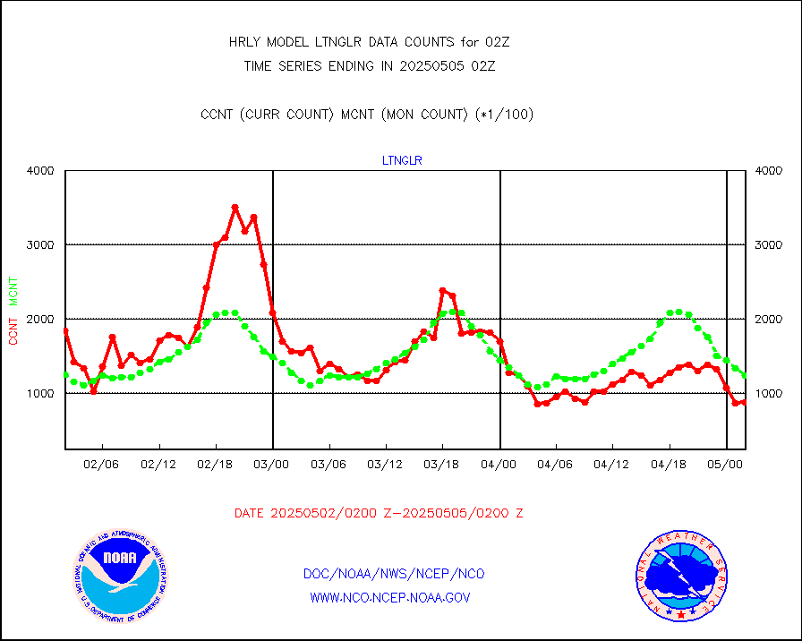
ltnglr |
LLDN Long-rng lightning from Vaisala via NOAAPORT |
135924 |
164458 |
82.6 % |
2001.50-2002.49 |
ltngsr |
NLDN Shrt-rng lightning from Vaisala via NOAAPORT |
7817 |
5093 |
153.5 % |
2001.50-2002.49 |
mbuoyb |
Moored buoys (decoded from BUFR) |
783 |
720 |
108.7 % |
2001.50-2002.50 |
mls |
Aura Microwave Limb Sounder (MLS) ozone data |
0 |
0 |
n/a |
2000.00-2000.99 |
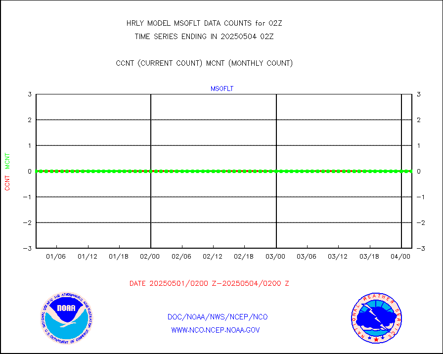
msourb |
Mesonet/MADIS UrbaNet |
4371 |
4348 |
100.5 % |
2001.50-2002.49 |
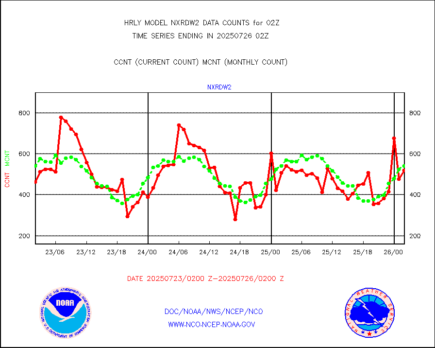
nxrdw2 |
NEXRAD Vel Azm Dsp(VAD) winds via Level 2 decoder |
643 |
642 |
100.2 % |
2001.50-2002.49 |
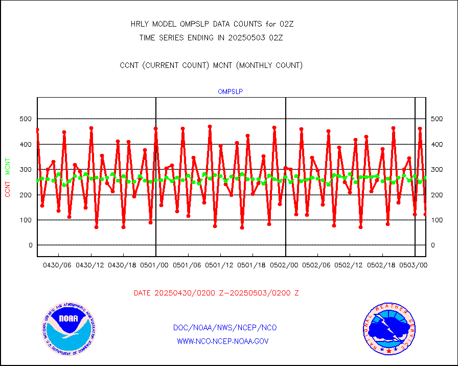
ompslp |
OMPS Limb Profiler ozone data (NPP) |
168 |
258 |
65.1 % |
1919.00-1919.99 |
ompsn8 |
OMPS nadir profile ozone (Version 8 BUFR) |
523 |
536 |
97.6 % |
2000.00-2000.99 |
ompst8 |
OMPS total column ozone (Version 8 BUFR) |
212391 |
321213 |
66.1 % |
2000.00-2000.99 |
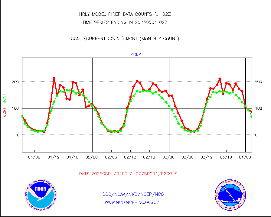
pirep |
Manual PIREP aircraft data (dcded from AIREP fmt) |
33 |
57 |
57.9 % |
2001.50-2002.49 |
prflrp |
Profilr winds from PIBAL (PILOT,PILOT SHIP/MOBIL) |
0 |
0 |
n/a |
2001.50-2002.49 |
raobm |
Rawinsonde - mobile land (from TEMP/PILOT MOBIL) |
0 |
0 |
n/a |
2001.50-2002.49 |
raobs |
Rawinsonde - ship (from TEMP SHIP, PILOT SHIP) |
0 |
0 |
n/a |
2001.50-2002.49 |
recco |
Flight level reconnaissance aircraft data |
0 |
0 |
n/a |
2001.50-2002.49 |
saphir |
Megha-Tropiques SAPHIR L1A2 brightness temps |
0 |
0 |
n/a |
1923.50-2000.49 |
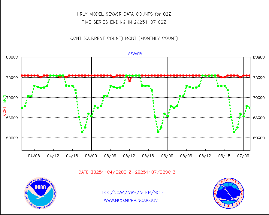
sevasr |
METEOSAT-10 2nd Gen SEVIRI All Sky Radiance(proc) |
75512 |
75453 |
100.1 % |
2001.50-2002.49 |
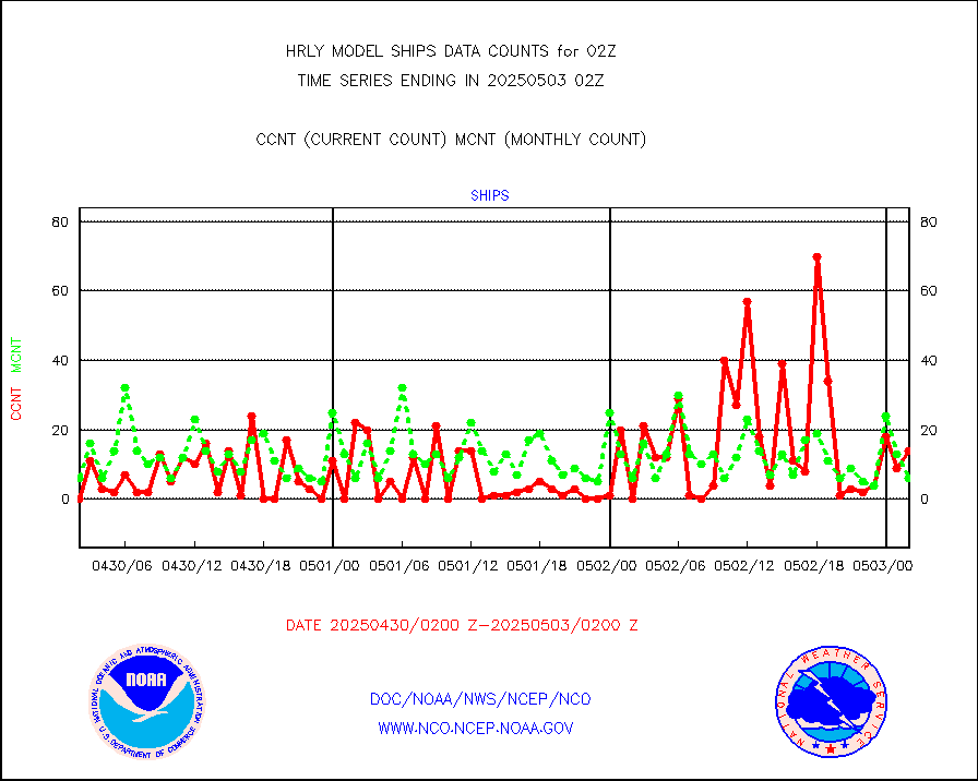
ships |
Ship - manual and automatic, restricted |
9 |
5 |
180.0 % |
2001.50-2002.49 |
ssmisu |
DMSP SSM/IS 1C radiance data (Unified Pre-Proc.) |
100980 |
148654 |
67.9 % |
2000.50-2001.49 |
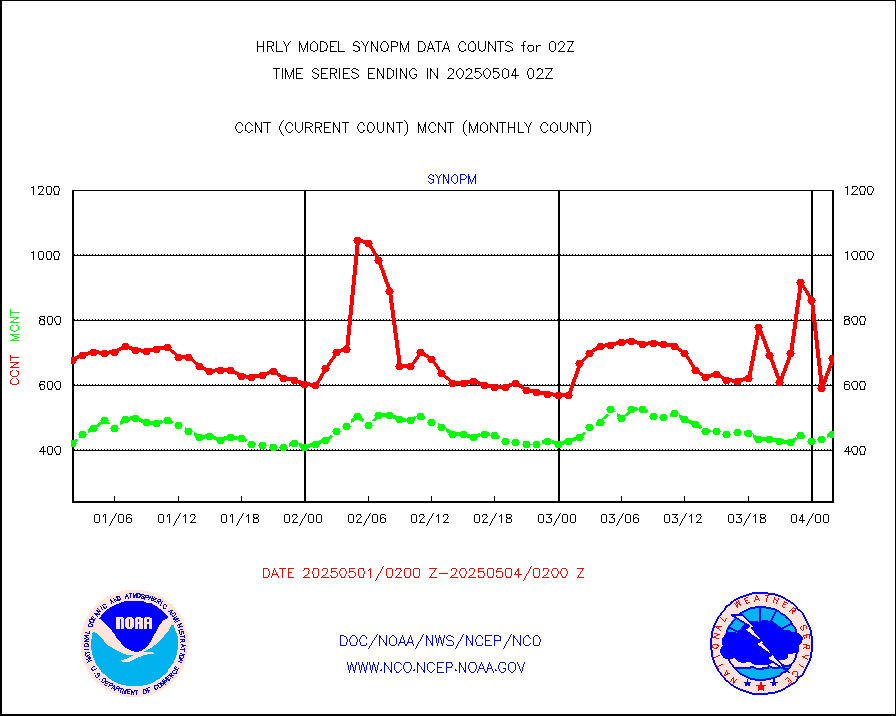
synopm |
Synoptic - mobile manual and automatic |
0 |
522 |
0.0 % |
2001.50-2002.49 |
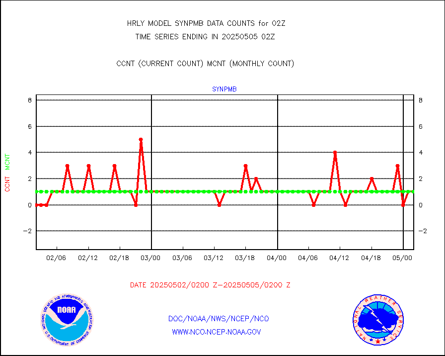
synpmb |
Synoptic - mobile manual & auto (decoded fr BUFR) |
0 |
1 |
0.0 % |
2001.50-2002.49 |
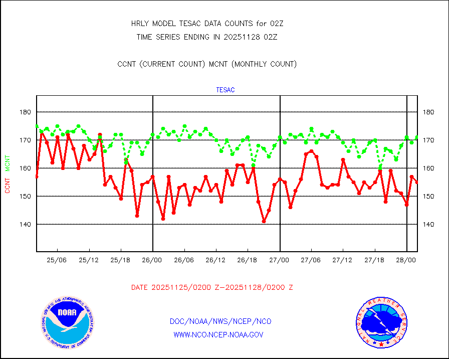
tesac |
CTD probe, Argo prflng float, mooring (TESAC fmt) |
198 |
191 |
103.7 % |
2001.50-2002.49 |
tmdara |
TAMDAR aircft data-all types(from Panasonic,BUFR) |
315 |
360 |
87.5 % |
2001.50-2002.49 |
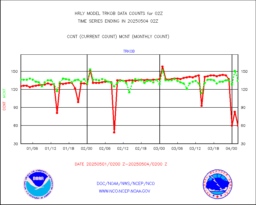
trkob |
ThermoSalinoGraph (TSG) TRACKOB format) |
74 |
45 |
164.4 % |
2000.50-2001.49 |
visin |
INSAT/KALPANA India visible derived cloud motion |
0 |
0 |
n/a |
1923.50-2000.49 |
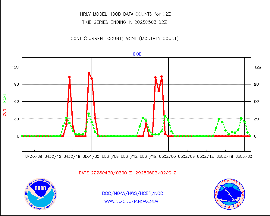
visin2 |
INDIA SATWIND, INSAT VIS channel |
0 |
11 |
0.0 % |
2001.00-2001.99 |
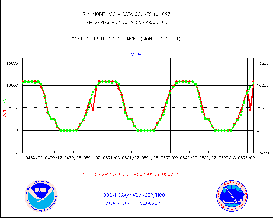
visja |
MTSAT/JMA visible derived cloud motion |
10765 |
10703 |
100.6 % |
1923.50-2000.49 |
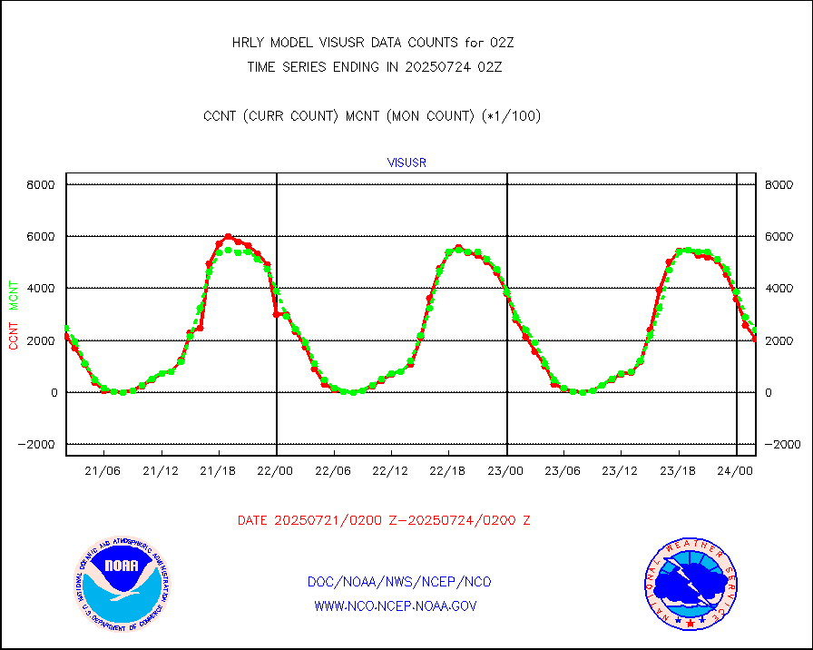
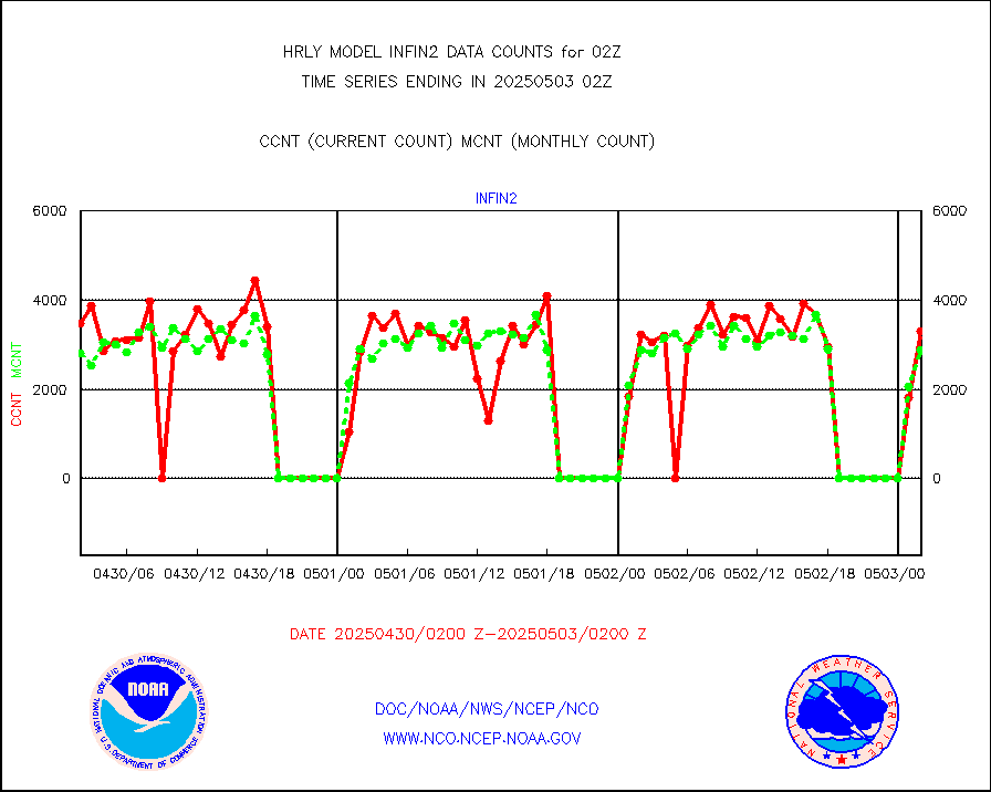
visusr |
GOES-16&up/NESDIS visible derived cloud motion |
177364 |
197184 |
89.9 % |
2001.00-2001.99 |
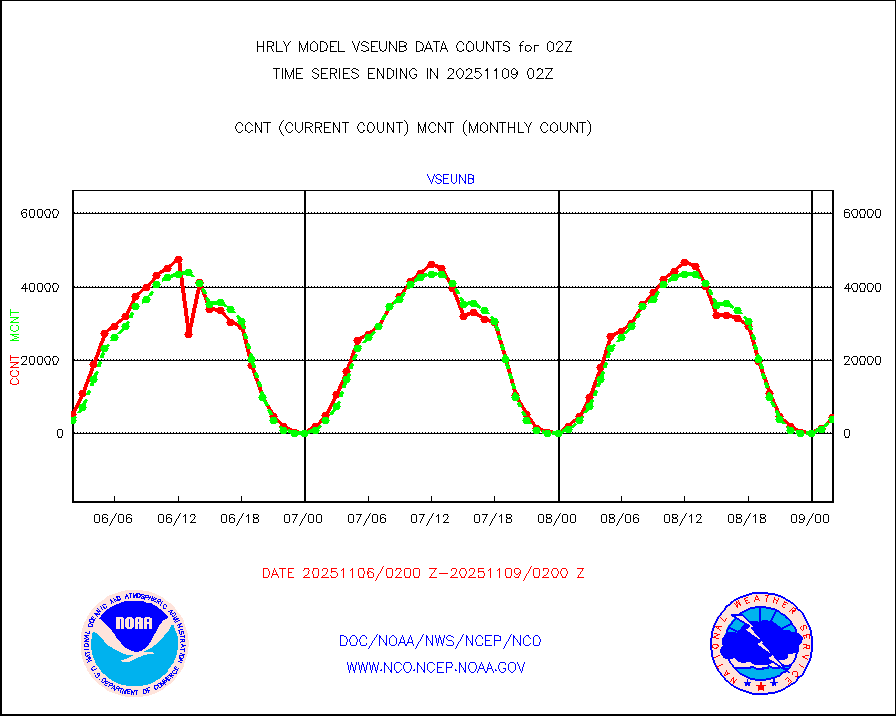
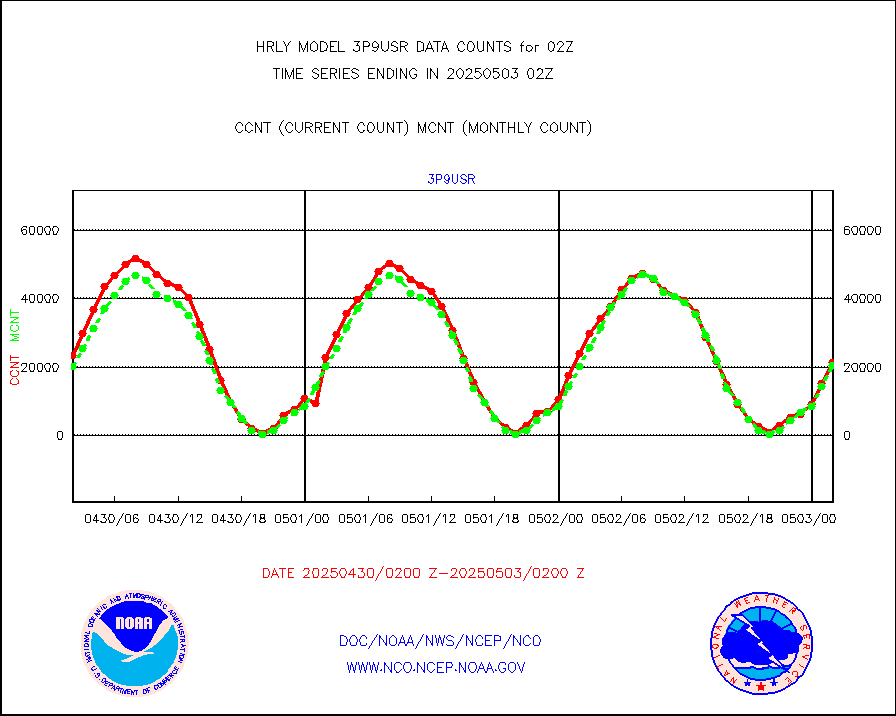
vseunb |
METEOSAT/EUMETSAT visible drv cld motion NBseq |
990 |
1166 |
84.9 % |
2000.50-2001.49 |


