| Critical Data with Normal Counts |
|---|
| Type | Description | Hourly Count | Monthly Average | Percent (%) of Monthly Mean | UTC Time Window |
1bamua |
NOAA 15-19 & METOP 1-2 AMSU-A NCEP-proc. br.temps |
58059 |
54380 |
106.8 % |
1922.00-1922.99 |
1bhrs4 |
NOAA 18-19 & METOP 1-2 HIRS-4 NCEP-proc. br.temps |
59242 |
47907 |
123.7 % |
1922.00-1922.99 |
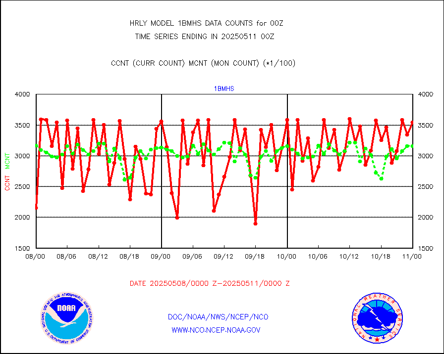
1bmhs |
NOAA 18-19 & METOP 1-2 MHS NCEP-proces. br. temps |
282950 |
297442 |
95.1 % |
1922.00-1922.99 |
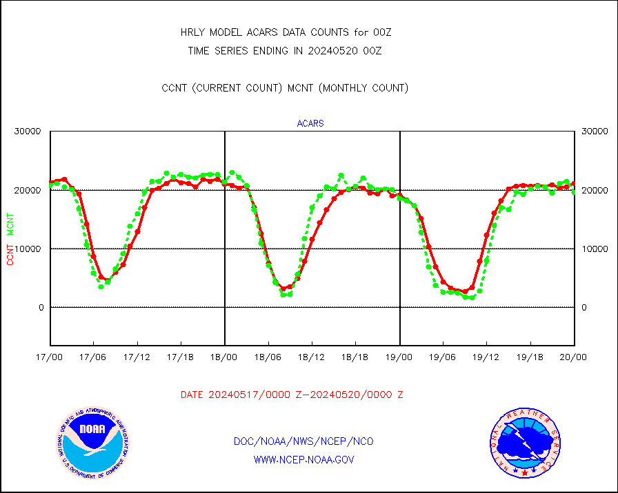
acars |
MDCRS ACARS acft data from ARINC(dcded from BUFR) |
21140 |
19559 |
108.1 % |
1923.50-2000.49 |
airep |
Manual AIREP aircraft data (dcded from AIREP fmt) |
727 |
633 |
114.8 % |
1923.50-2000.49 |
airsev |
AQUA AIRS/AMSU-A/HSB brightness temps- every FOV |
0 |
0 |
n/a |
1921.50-1922.49 |
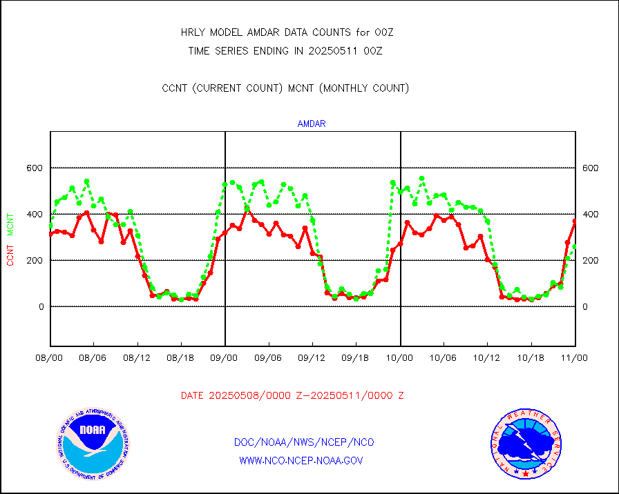
amdar |
AMDAR aircraft data (decoded from AMDAR format) |
342 |
321 |
106.5 % |
1923.50-2000.49 |
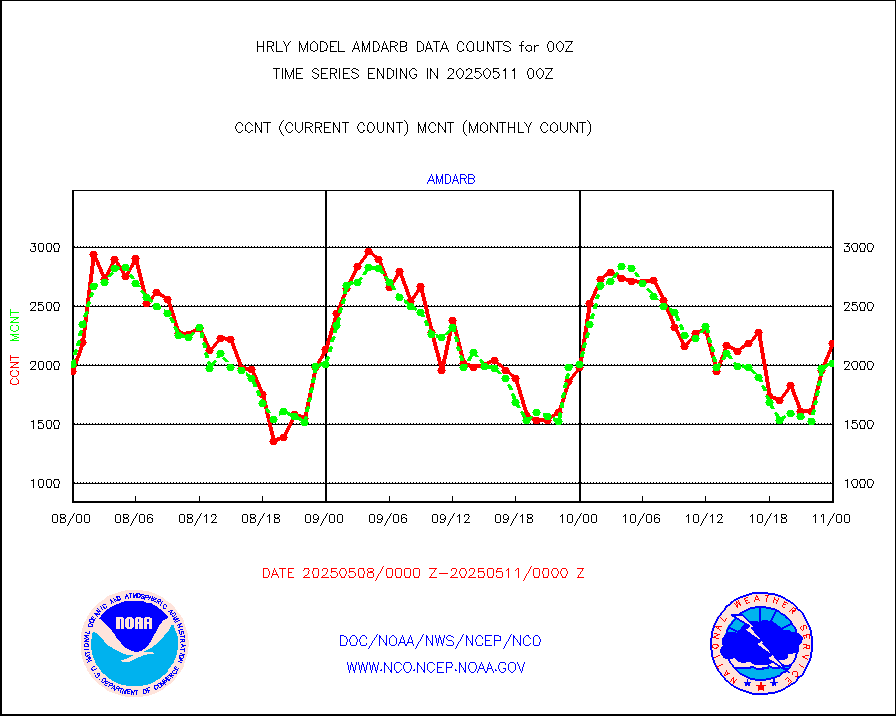
amdarb |
AMDAR aircraft data (decoded from BUFR) |
862 |
907 |
95.0 % |
1923.50-2000.49 |
ascat |
METOP 1-2 ASCAT products |
41160 |
47474 |
86.7 % |
1922.50-1923.49 |
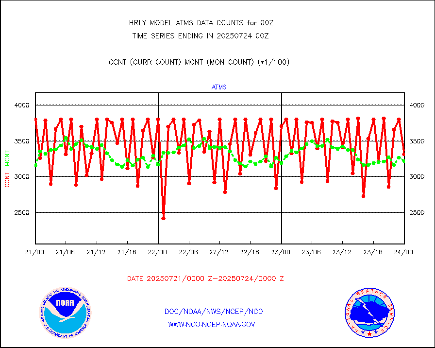
atms |
NPP/NOAA-20 ATMS brightness temperatures |
380352 |
329402 |
115.5 % |
1922.50-1923.49 |
camdar |
Canadian AMDAR aircraft data (decoded from BUFR) |
0 |
2 |
0.0 % |
1923.50-2000.49 |
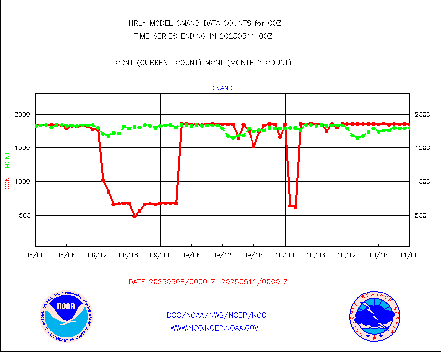
cmanb |
Surface Marine CMAN rpts decoded from BUFR format |
1551 |
1740 |
89.1 % |
1923.50-2000.50 |
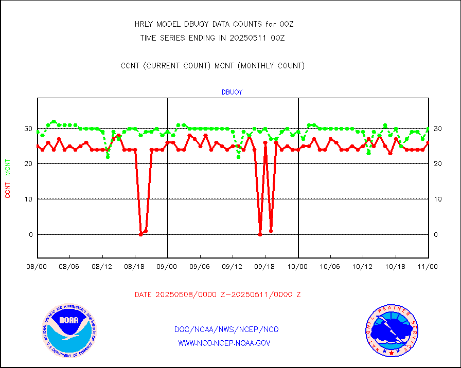
dbuoy |
Buoys decoded from FM-18 fmt (moored or drifting) |
39 |
33 |
118.2 % |
1923.50-2000.49 |
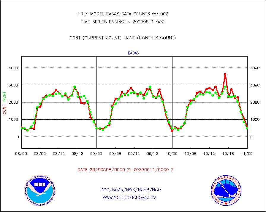
eadas |
E-AMDAR (European AMDAR acft decoded from BUFR) |
465 |
380 |
122.4 % |
1923.50-2000.49 |
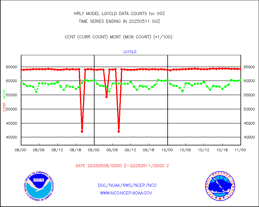
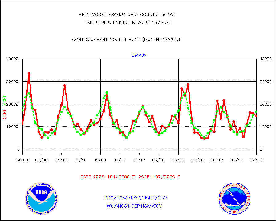
esamua |
NOAA 15-19 & METOP 1-2 AMSU-A proc btmps frm RARS |
40729 |
33819 |
120.4 % |
1923.50-2000.49 |
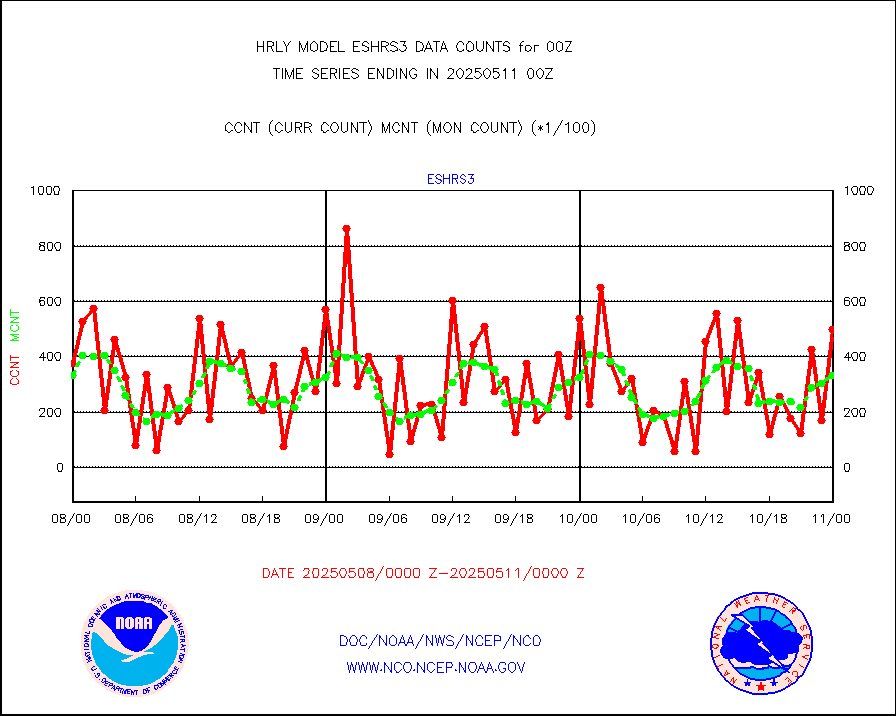
eshrs3 |
NOAA 15-19 & METOP 1-2 HIRS-3/4 pr btmps frm RARS |
96497 |
66490 |
145.1 % |
1923.50-2000.49 |
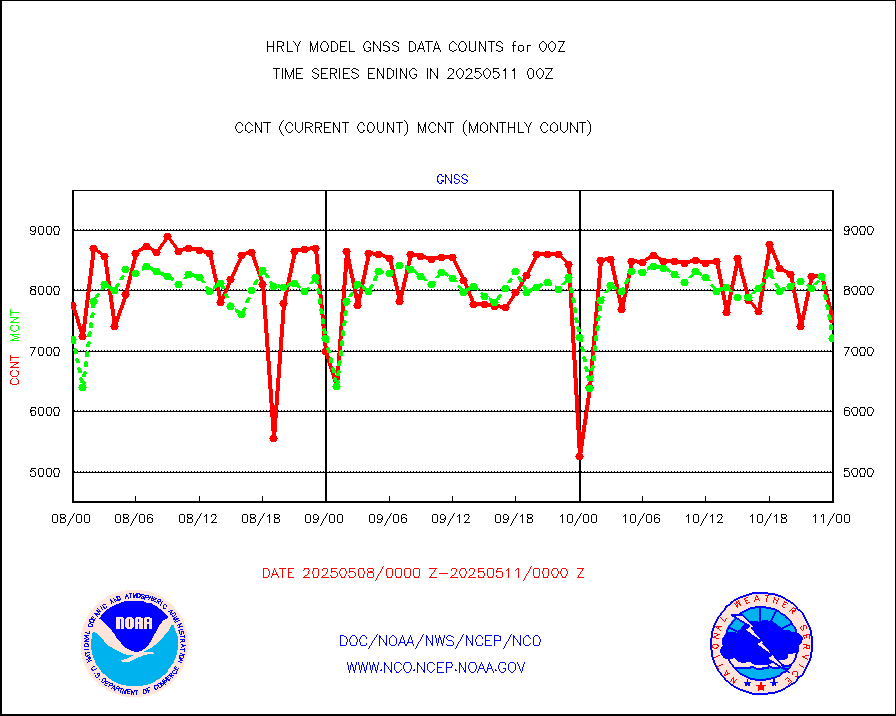
gnss |
Grnd-based Gbl Navigation Sat System (GNSS) data |
7955 |
8101 |
98.2 % |
1923.00-1923.99 |
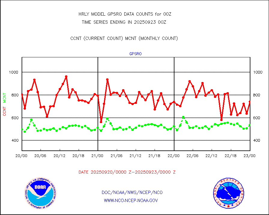
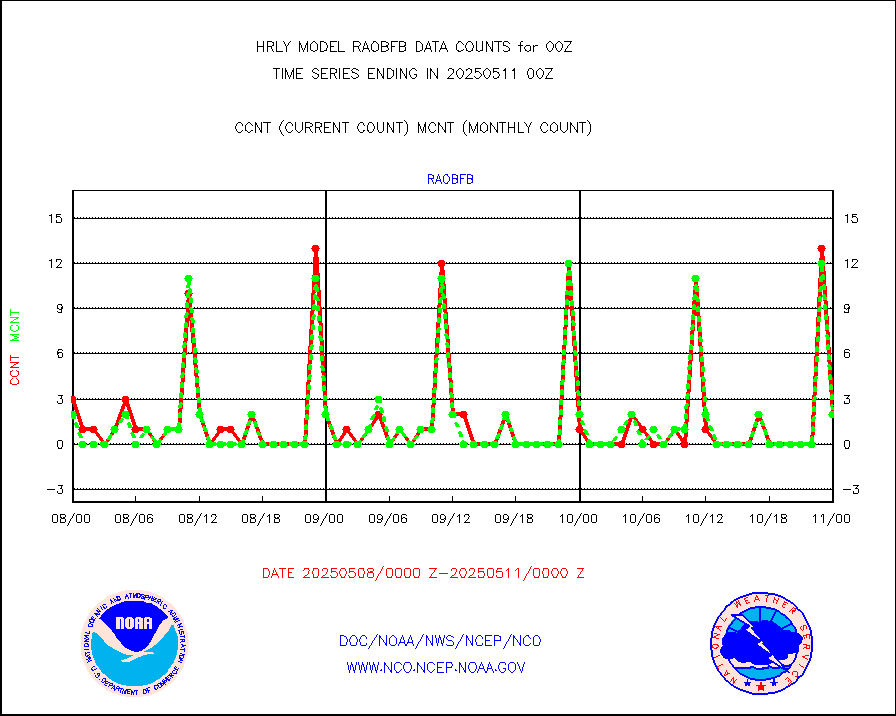
gpsro |
GPS radio occultation data |
518 |
481 |
107.7 % |
1921.50-1922.49 |
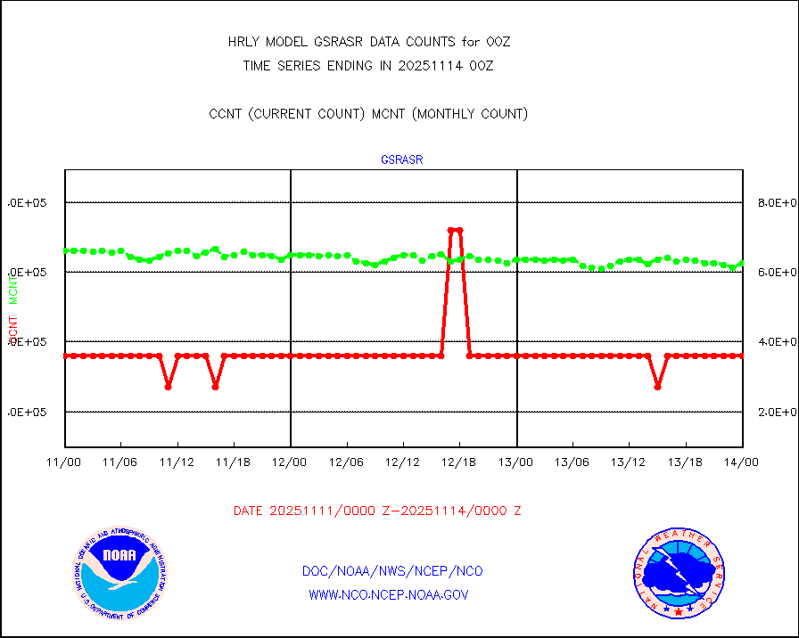
gsrasr |
GOES-16/17 All Sky Radiances (proc.) |
360476 |
345156 |
104.4 % |
1923.50-2000.49 |
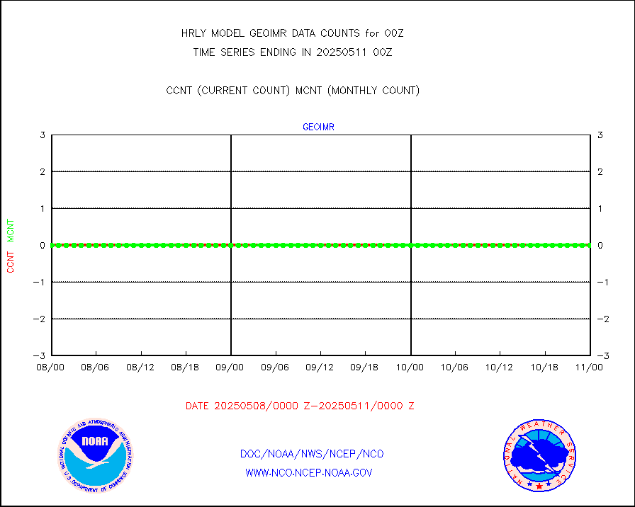
gsrcsr |
GOES-16/17 Clear Sky Radiances (proc.) |
168350 |
172915 |
97.4 % |
1923.50-2000.49 |
h20ja |
MTSAT/JMA water vapor imager derived cloud motion |
19355 |
17930 |
107.9 % |
1921.50-1922.49 |
h20mo |
MODIS (AQUA/TERRA) wvpr imager derived cld motion |
0 |
0 |
n/a |
1920.00-1920.99 |
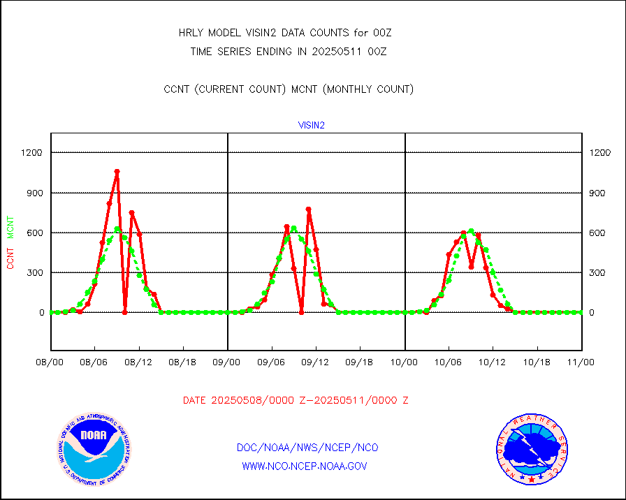
h2tusr |
GOES-16&up/NESDIS wv imgr/cld-top derived cld mtn |
29264 |
28547 |
102.5 % |
1923.00-1923.99 |
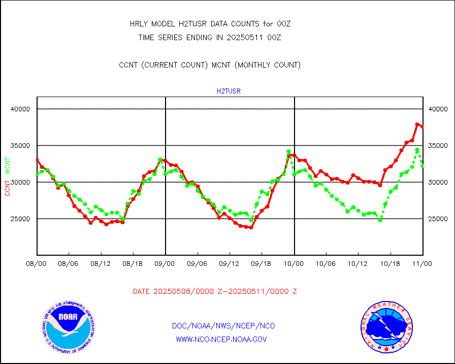
ifeunb |
METEOSAT/EUMETSAT ir lg-wave drv cld motion NBseq |
21095 |
21354 |
98.8 % |
1922.50-1923.49 |
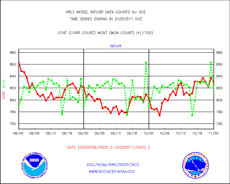
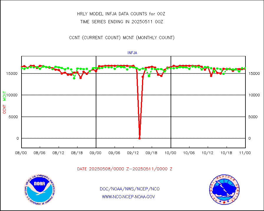
infja |
MTSAT/JMA infrared long-wave derived cloud motion |
16046 |
15291 |
104.9 % |
1921.50-1922.49 |
infmo |
MODIS (AQUA/TERRA) ir l-wave derived cloud motion |
0 |
0 |
n/a |
1920.00-1920.99 |
infusr |
GOES-16&up/NESDIS ir long-wave derived cld motion |
77803 |
78405 |
99.2 % |
1923.00-1923.99 |
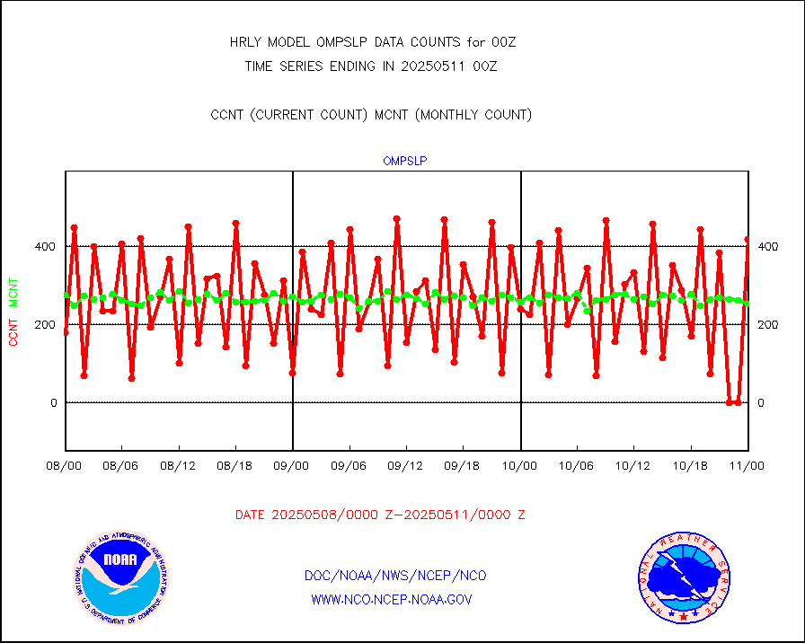
lgycld |
GOES/NASA(Langley) hi-res. (1x1 f-o-v) cloud data |
4190787 |
3629414 |
115.5 % |
1923.50-2000.49 |
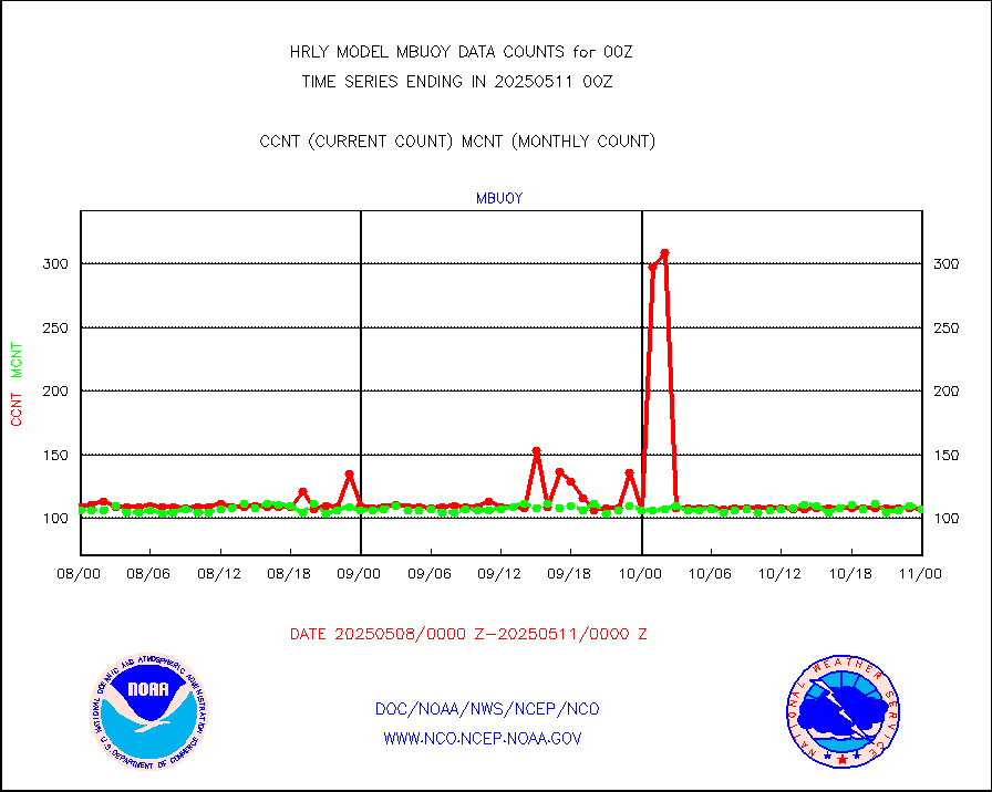
mbuoy |
Buoys decoded from FM-13 format (moored) |
118 |
111 |
106.3 % |
1923.50-2000.49 |
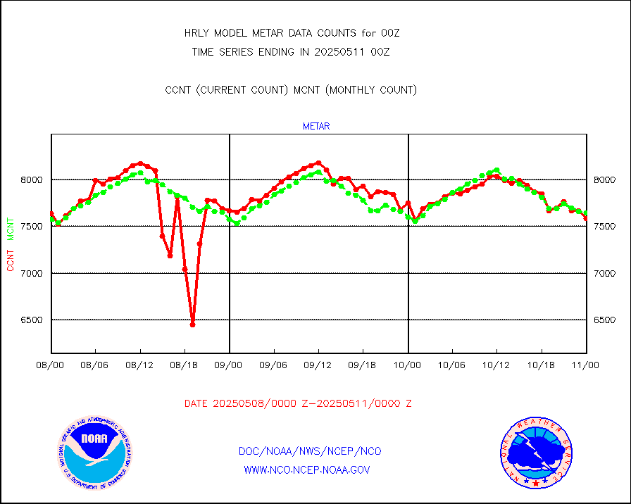
metar |
Aviation - METAR |
7315 |
7582 |
96.5 % |
1923.50-2000.49 |
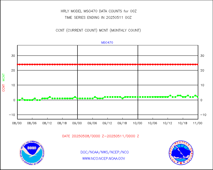
mso470 |
Mesonet/MADIS Colorado E-470 (Interstate 470) |
21 |
20 |
105.0 % |
1923.50-2000.49 |
msoalk |
Mesonet/MADIS Alaska Department of Transportation |
110 |
105 |
104.8 % |
1923.50-2000.49 |
msoapg |
Mesonet/MADIS U.S. Army Aberdeen Proving Grounds |
0 |
0 |
n/a |
1923.50-2000.49 |
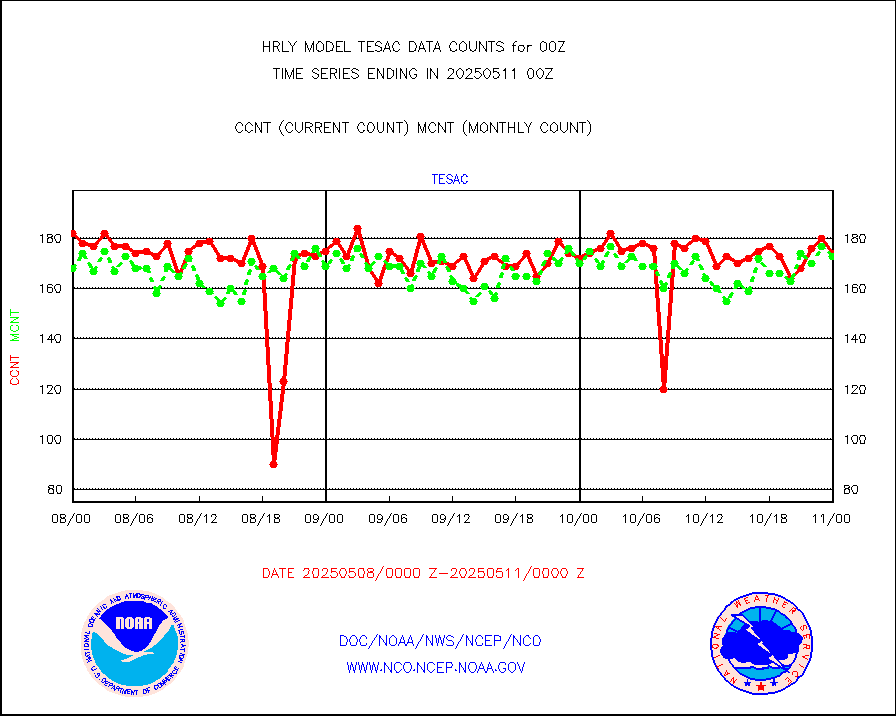
msoapr |
Mesonet/MADIS Citizen Weather Observers Program |
49967 |
49287 |
101.4 % |
1923.50-2000.49 |
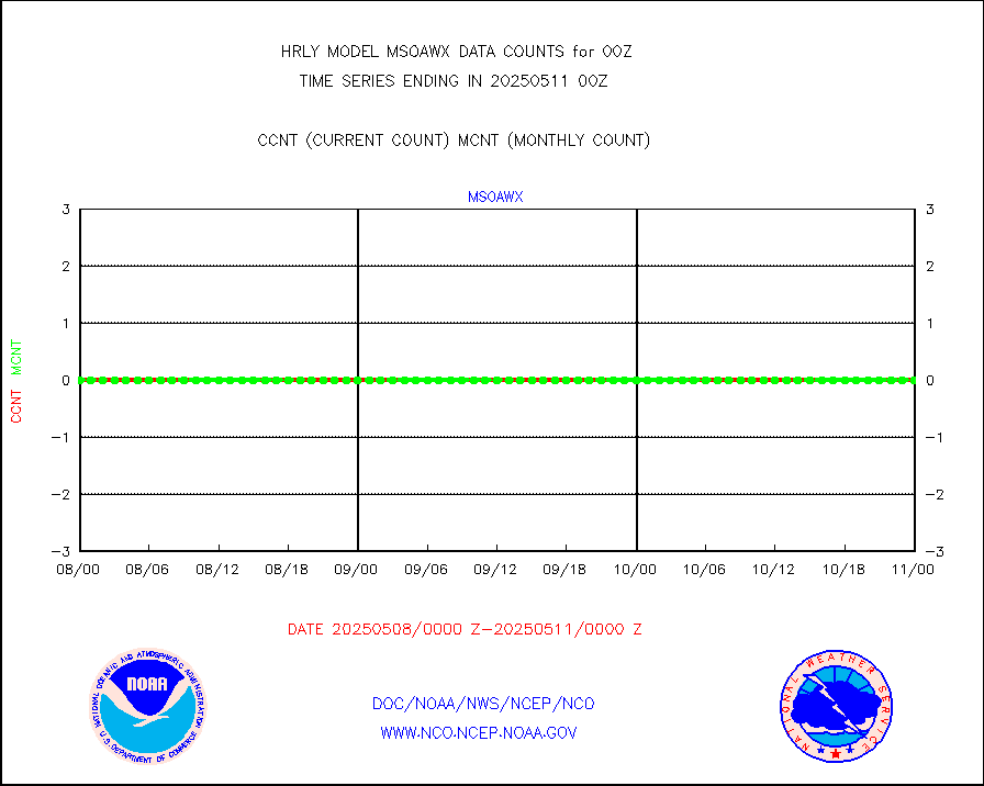
msoaws |
Mesonet/MADIS AWS Convergence Technologies, Inc. |
24870 |
25510 |
97.5 % |
1923.50-2000.49 |
msoawx |
Mesonet/MADIS "Anything Weather" |
0 |
0 |
n/a |
1923.50-2000.49 |
msocol |
Mesonet/MADIS Colorado Dept. of Transportation |
0 |
0 |
n/a |
1923.50-2000.49 |
msodcn |
Mesonet/MADIS DC Net |
0 |
0 |
n/a |
1923.50-2000.49 |
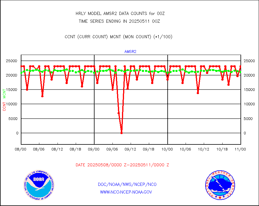
msoden |
Mesonet/MADIS Denver Urban Drainage & Flood Cntrl |
250 |
250 |
100.0 % |
1923.50-2000.49 |
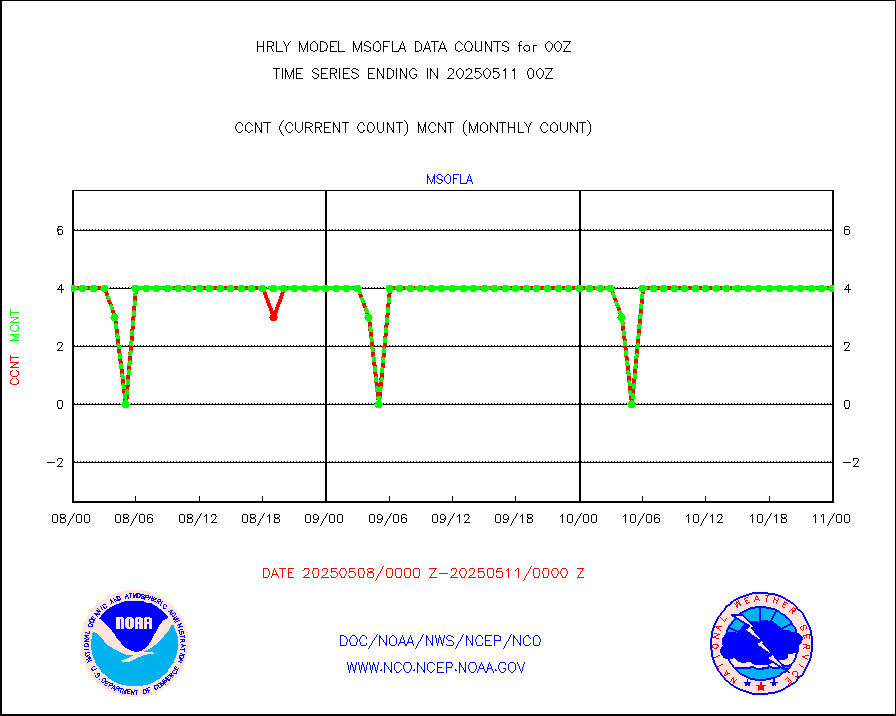
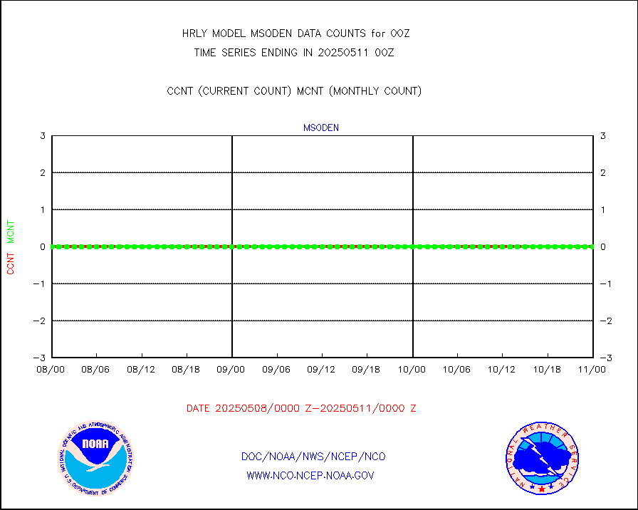
msofla |
Mesonet/MADIS Florida (FAWN & USF) |
4 |
4 |
100.0 % |
1923.50-2000.49 |
msoflt |
Mesonet/MADIS Florida Dept. of Transportation |
0 |
0 |
n/a |
1923.50-2000.49 |
msogeo |
Mesonet/MADIS Georgia Dept. of Transportation |
0 |
0 |
n/a |
1923.50-2000.49 |
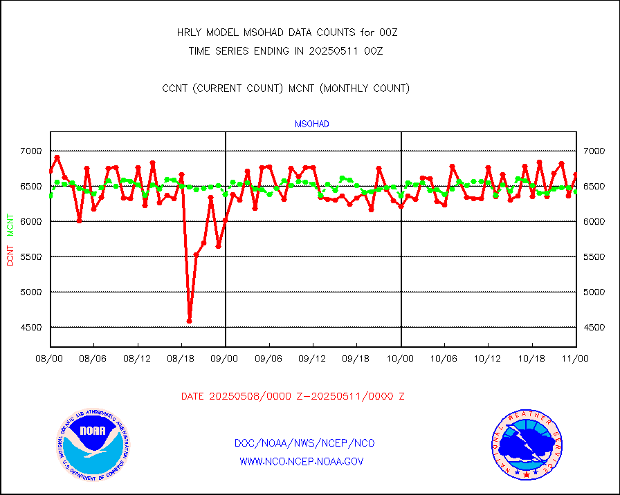
msohad |
Mesonet/MADIS NWS Hydromet Auto Data System(HADS) |
6365 |
6391 |
99.6 % |
1923.50-2000.49 |
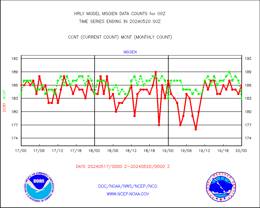
msoien |
Mesonet/MADIS Iowa Environmental |
186 |
183 |
101.6 % |
1923.50-2000.49 |
msoind |
Mesonet/MADIS Indiana Dept. of Transportation |
0 |
0 |
n/a |
1923.50-2000.49 |
msoiow |
Mesonet/MADIS Iowa Department of Transportation |
0 |
0 |
n/a |
1923.50-2000.49 |
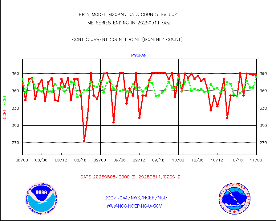
msokan |
Mesonet/MADIS Kansas Department of Transportation |
347 |
366 |
94.8 % |
1923.50-2000.49 |
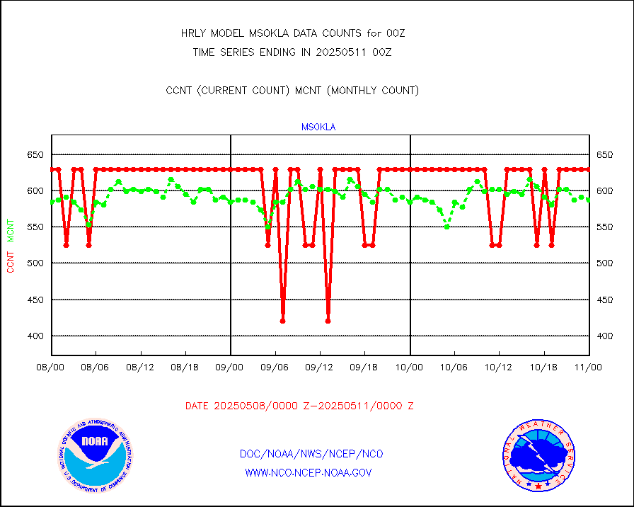
msokla |
Mesonet/MADIS Oklahoma Mesonet |
318 |
307 |
103.6 % |
1923.50-2000.49 |
msolju |
Mesonet/MADIS Louisiana State/Jackson State Univ. |
0 |
0 |
n/a |
1923.50-2000.49 |
msomca |
Mesonet/MADIS Missouri Commercial Agricult Wx Net |
301 |
290 |
103.8 % |
1923.50-2000.49 |
msomin |
Mesonet/MADIS Minnesota Dept. of Transportation |
0 |
0 |
n/a |
1923.50-2000.49 |
msonos |
Mesonet/MADIS NOS-Phys Oceanographic Realtime Sys |
317 |
309 |
102.6 % |
1923.50-2000.49 |
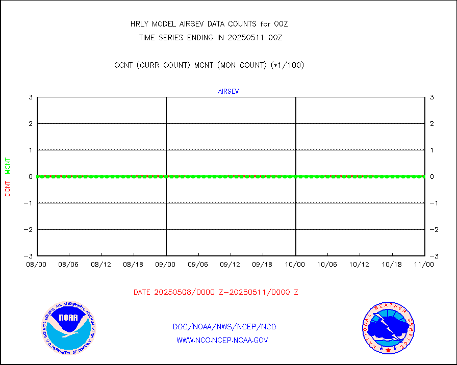
msoraw |
Mesonet/MADIS NFIC Remote Automated Wx Stns(RAWS) |
1933 |
1876 |
103.0 % |
1923.50-2000.49 |
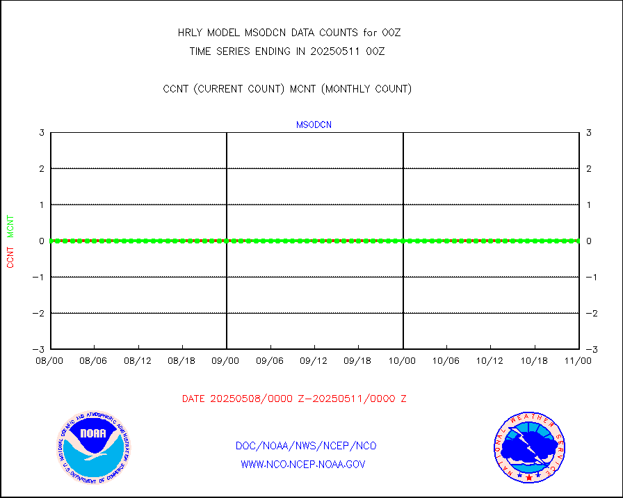
msovir |
Mesonet/MADIS Virginia Dept. of Transportation |
208 |
227 |
91.6 % |
1923.50-2000.49 |
msowfy |
Mesonet/MADIS "Weather for You" |
0 |
0 |
n/a |
1923.50-2000.49 |
msowis |
Mesonet/MADIS Wisconsin Dept. of Transportation |
0 |
0 |
n/a |
1923.50-2000.49 |
msowst |
Mesonet/MADIS MesoWest (many subproviders) |
46625 |
45872 |
101.6 % |
1923.50-2000.49 |
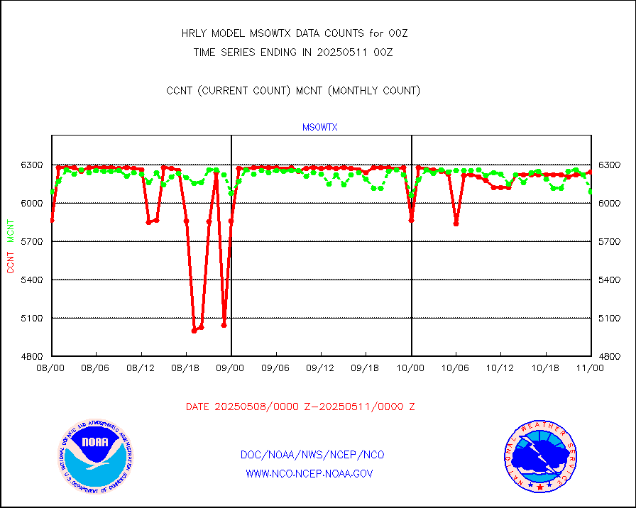
msowtx |
Mesonet/MADIS West Texas |
5638 |
5524 |
102.1 % |
1923.50-2000.49 |
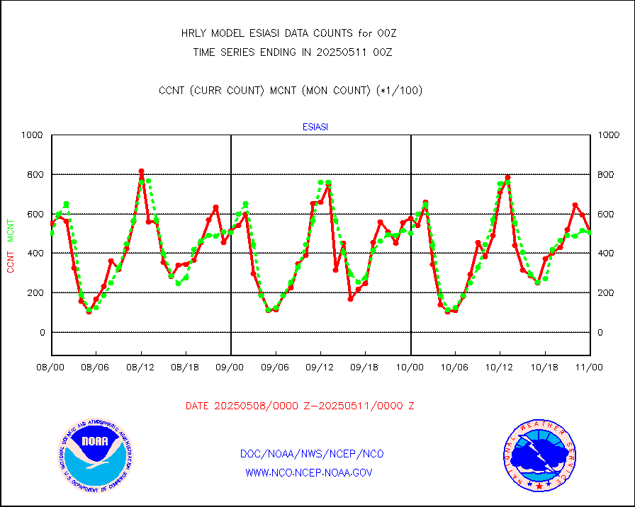
mtiasi |
METOP 1-2 IASI 1C radiance data (varbl. channels) |
72252 |
84006 |
86.0 % |
1922.00-1922.99 |
nxrdw |
NEXRAD Vel Azm Dsp(VAD) winds via radar coded msg |
0 |
0 |
n/a |
1923.50-2000.49 |
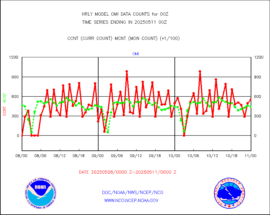
omi |
Aura Ozone Monitoring Instrument (OMI) data |
42600 |
30934 |
137.7 % |
1921.50-1922.49 |
osbuv8 |
NOAA 16-19 Solar Backscatter UV-2 rad frm V8 BUFR |
0 |
0 |
n/a |
1922.00-1922.99 |
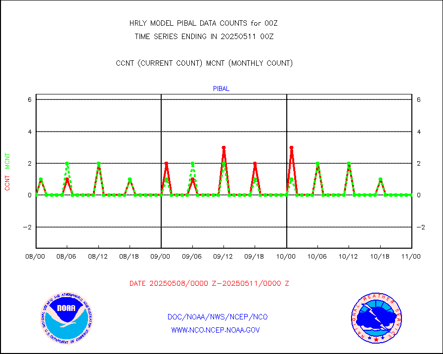
pibal |
PIBAL (from PILOT, PILOT SHIP, PILOT MOBIL) |
26 |
29 |
89.7 % |
1923.50-2000.49 |
prflrb |
Multi-Agency Profiler (MAP) and SODAR winds |
35 |
40 |
87.5 % |
1923.50-2000.49 |
raobf |
Rawinsonde - fixed land (from TEMP or PILOT) |
139 |
137 |
101.5 % |
1923.50-2000.49 |
rass |
RASS temperatures (NOAA and Multi-Agency) |
24 |
27 |
88.9 % |
1923.50-2000.49 |
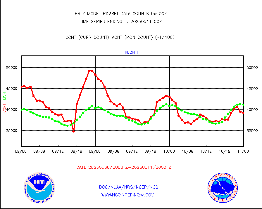
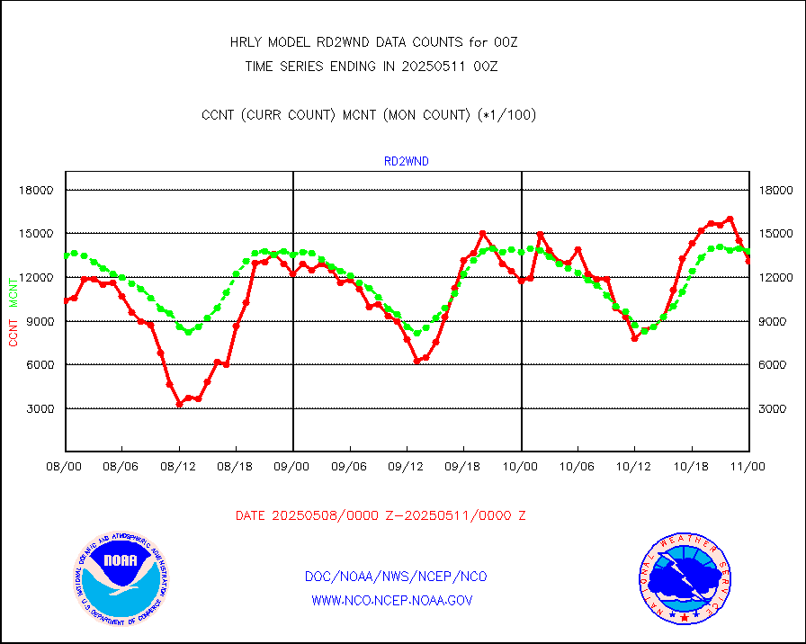
rd2rft |
NEXRAD reflectivity (Lvl 2 - GTS) |
4310416 |
4192505 |
102.8 % |
1923.50-2000.49 |
rd2wnd |
NEXRAD radial wind (Level 2 - GTS) |
1753311 |
1545686 |
113.4 % |
1923.50-2000.49 |
sevcsr |
METEOSAT-10 2nd Gen SEVIRI Clr Sky Radiance(proc) |
0 |
0 |
n/a |
1923.50-2000.49 |
shipsb |
Ship - manual and automatic, restricted (BUFR) |
0 |
0 |
n/a |
1923.50-2000.50 |
shipsu |
Ship - manual and automatic, unrestricted |
191 |
165 |
115.8 % |
1923.50-2000.50 |
shipub |
Ship - manual and automatic, unrestricted (BUFR) |
800 |
842 |
95.0 % |
1923.50-2000.50 |
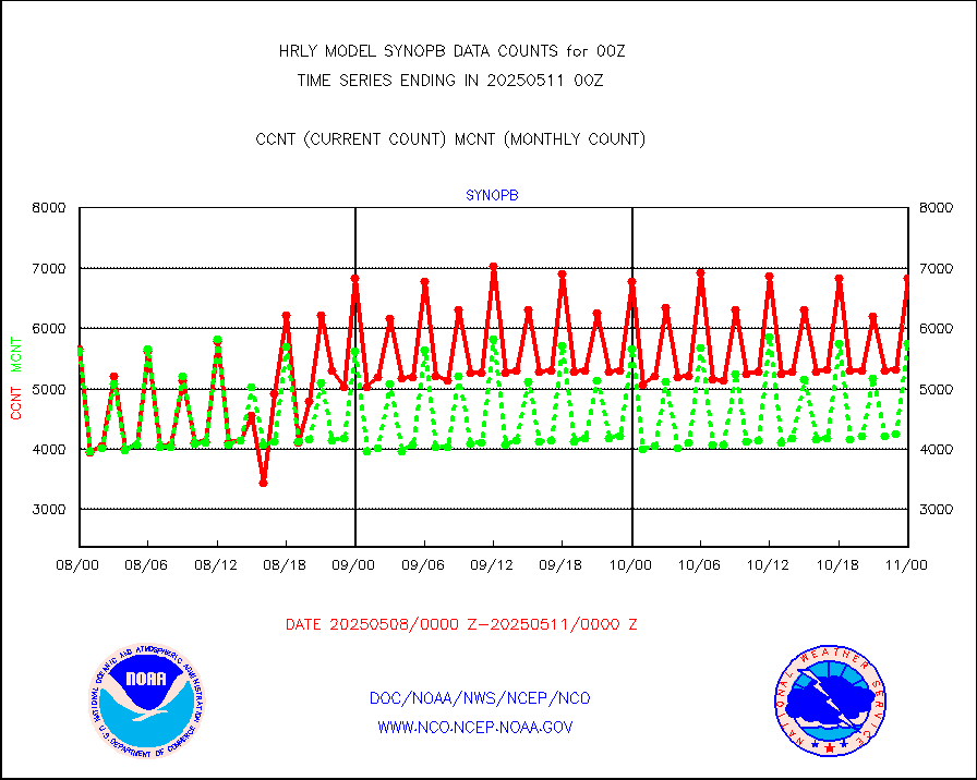
synop |
Synoptic - fixed manual and automatic |
1926 |
1893 |
101.7 % |
1923.50-2000.49 |
synopb |
Synoptic - fixed manual & auto (decoded fr BUFR) |
5789 |
5810 |
99.6 % |
1923.50-2000.49 |
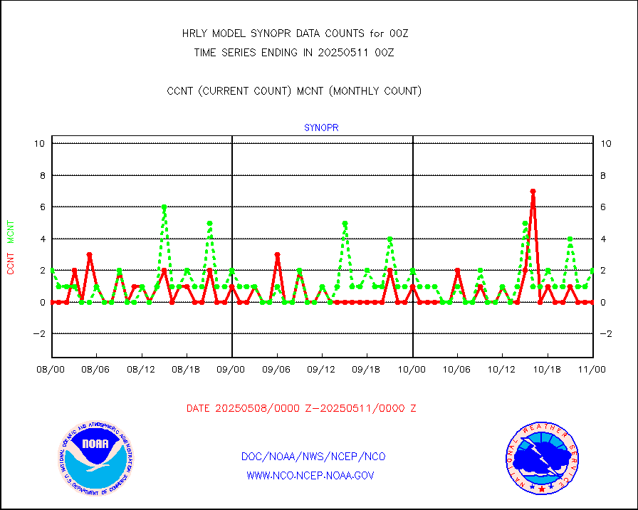
synopr |
Synoptic - restricted (WMO Res 40) manual & auto. |
1 |
1 |
100.0 % |
1923.50-2000.49 |
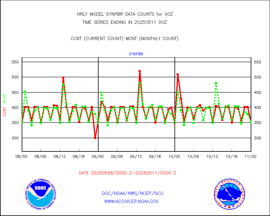
synpbr |
Synoptic - restricted (WMO Res 40)(decoded BUFR) |
347 |
350 |
99.1 % |
1923.50-2000.49 |
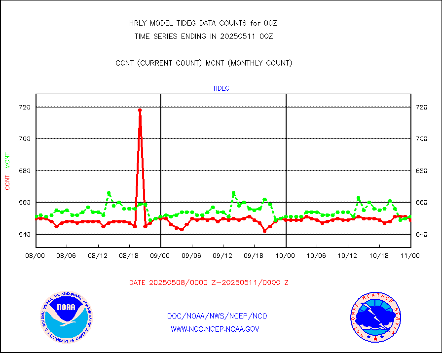
tideg |
Tide gauge reports decoded from CREX format |
645 |
640 |
100.8 % |
1923.00-1923.99 |
| Data Types of Opportunity with Normal Counts |
|---|
| Type | Description | Hourly Count | Monthly Average | Percent (%) of Monthly Mean | UTC Time Window |
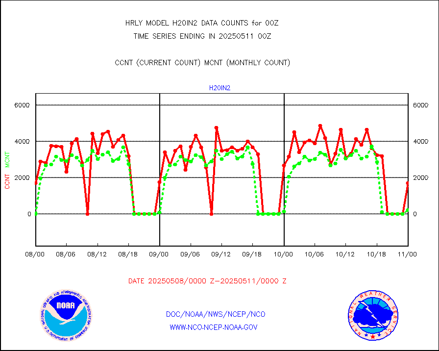
3p9usr |
GOES-16&up/NESDIS ir short-wv derived cld motion |
8269 |
9289 |
89.0 % |
1923.00-1923.99 |
acarsa |
MDCRS ACARS acft data (ARINC via AFWA)(AIREP fmt) |
0 |
0 |
n/a |
1923.50-2000.49 |
ahicsr |
Himawari Clear Sky Radiance |
0 |
0 |
n/a |
1923.00-1923.99 |
amsr2 |
GCOM-W AMSR2 1B brightness temperatures |
2309472 |
2107199 |
109.6 % |
1922.00-1922.99 |
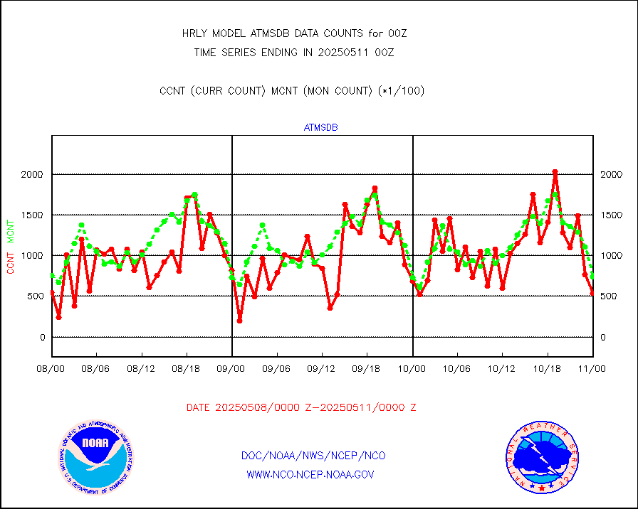
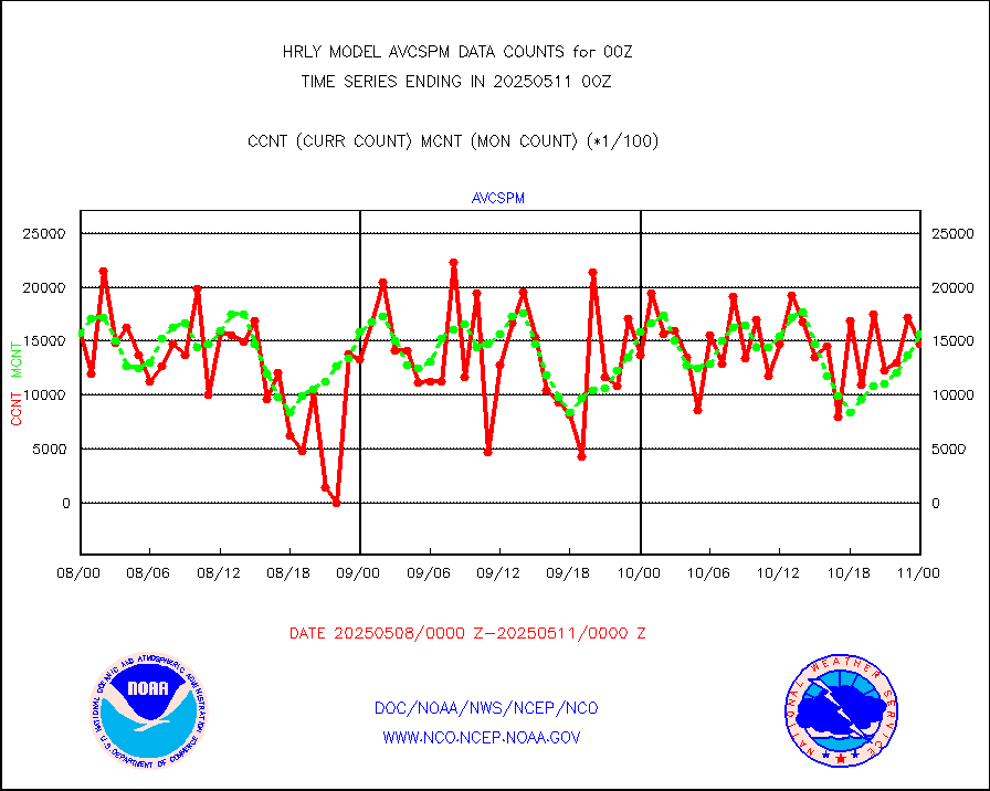
atmsdb |
NPP/NOAA-20 ATMS bright. temps-direct b-cast SSEC |
82225 |
80681 |
101.9 % |
1922.50-1923.49 |
atovs |
POES/NESDIS - processed ATOVS soundings/radiances |
0 |
0 |
n/a |
1922.00-1922.99 |
avcsam |
A.M.(N17,M2,M3) AVHRR GAC NCEP-proc clr&sea btmps |
1286046 |
1521701 |
84.5 % |
1921.50-1922.49 |
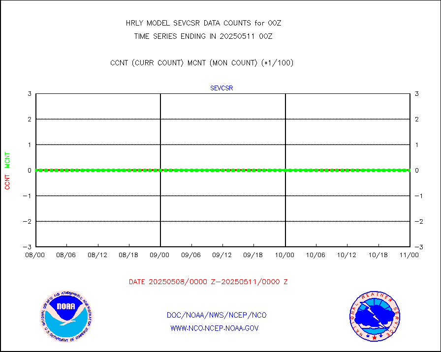
avcspm |
P.M.(N18-19) AVHRR GAC NCEP-proc clr & sea btemps |
1647087 |
1609586 |
102.3 % |
1921.50-1922.49 |
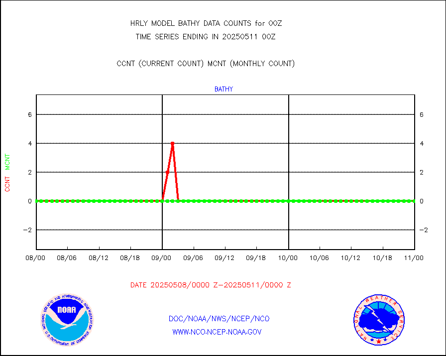
bathy |
eXpendable BathyThermograph, mooring (BATHY fmt) |
0 |
0 |
n/a |
1917.00-1917.99 |
coopmd |
Coop/MADIS NEPP & HCN-Modernization NOAA COOP Obs |
27 |
27 |
100.0 % |
1923.50-2000.49 |
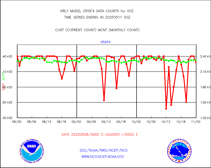
crisf4 |
NPP/NOAA-20 CrIS full spctrl radn (431 ch subset) |
212796 |
220393 |
96.6 % |
1922.50-1923.49 |
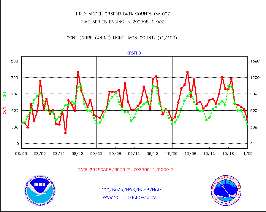
crsfdb |
NPP/NOAA-20 CrIS full spctrl radn dir brdcst SSEC |
110284 |
76643 |
143.9 % |
1922.50-1923.49 |
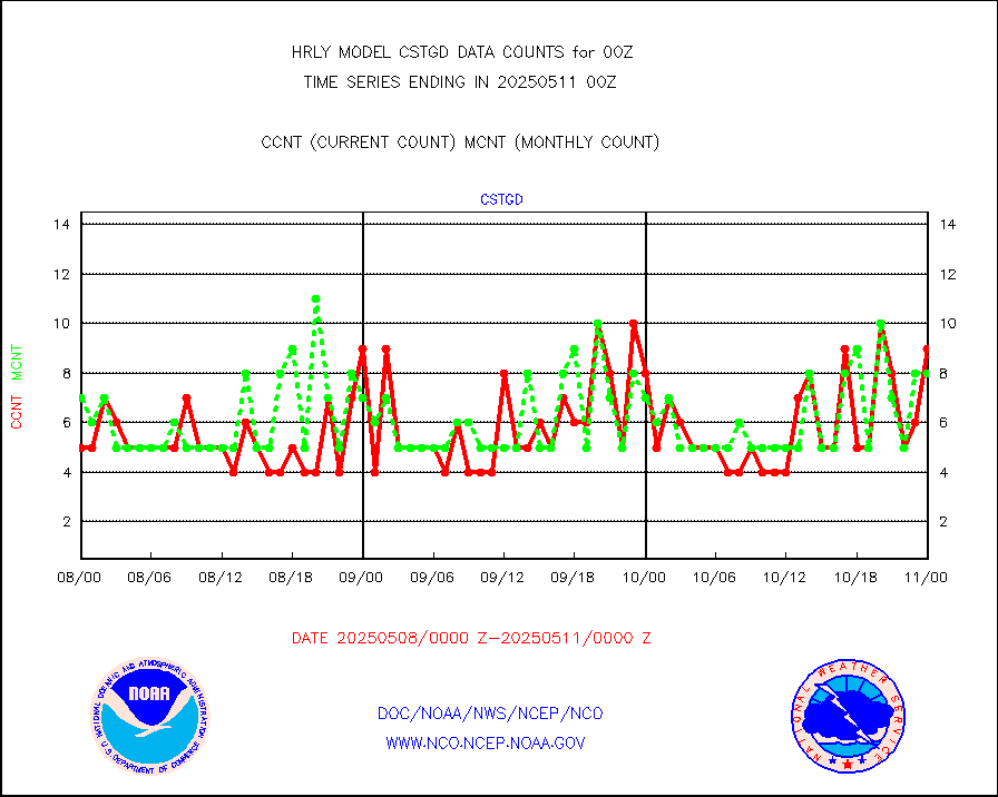
cstgd |
Coast Guard |
3 |
5 |
60.0 % |
1923.50-2000.50 |
dbuoyb |
Drifting buoys (decoded from BUFR) |
1324 |
1339 |
98.9 % |
1923.50-2000.50 |
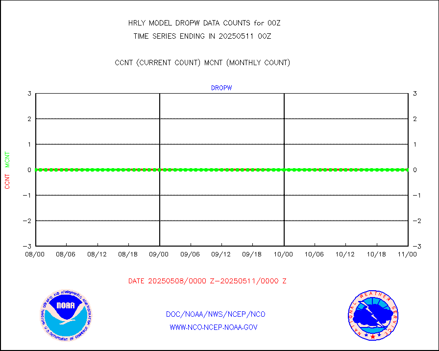
dropw |
Dropwinsonde (from TEMP DROP) |
0 |
0 |
n/a |
1923.50-2000.49 |
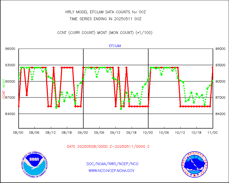
efclam |
GOES imager effective cloud amount data (U.Wisc.) |
8299557 |
8296430 |
100.0 % |
1923.50-2000.49 |
esatms |
NPP Adv. Tech. MW Sndr (ATMS) br. temps from RARS |
79182 |
69566 |
113.8 % |
1922.50-1923.49 |
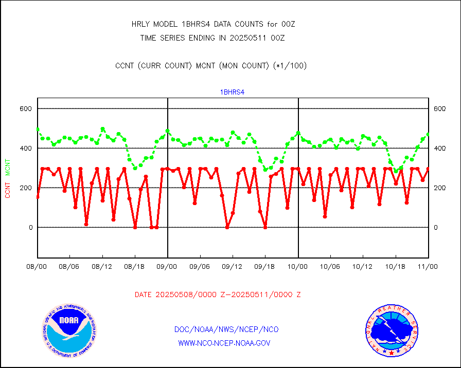
esiasi |
METOP 1-2 IASI 1C radiance data vbl chn from RARS |
72833 |
59364 |
122.7 % |
1923.00-1923.99 |
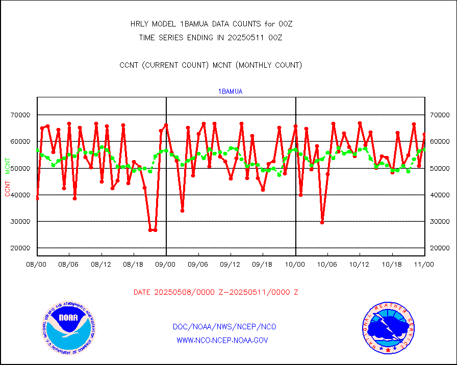
esmhs |
NOAA 18-19 & METOP 1-2 MHS proc. btemps from RARS |
252038 |
248211 |
101.5 % |
1923.50-2000.49 |
geoimr |
GOES/NESDIS (11x17 f-o-v) imager clear radiances |
0 |
0 |
n/a |
1923.00-1923.99 |
gome |
METOP 1-2 Global Ozone Monitoring Exp.-2 (GOME-2) |
8924 |
6496 |
137.4 % |
1922.50-1923.49 |
h20in2 |
INDIA SATWIND, INSAT WV channel |
3252 |
2342 |
138.9 % |
1923.00-1923.99 |
h2dusr |
GOES-16&up/NESDIS wv imgr/deep-lyr derivd cld mtn |
15591 |
16858 |
92.5 % |
1923.00-1923.99 |
h2eunb |
METEOSAT/EUMETSAT wvpr imgr drv cld motion NBseq |
38712 |
40909 |
94.6 % |
1922.50-1923.49 |
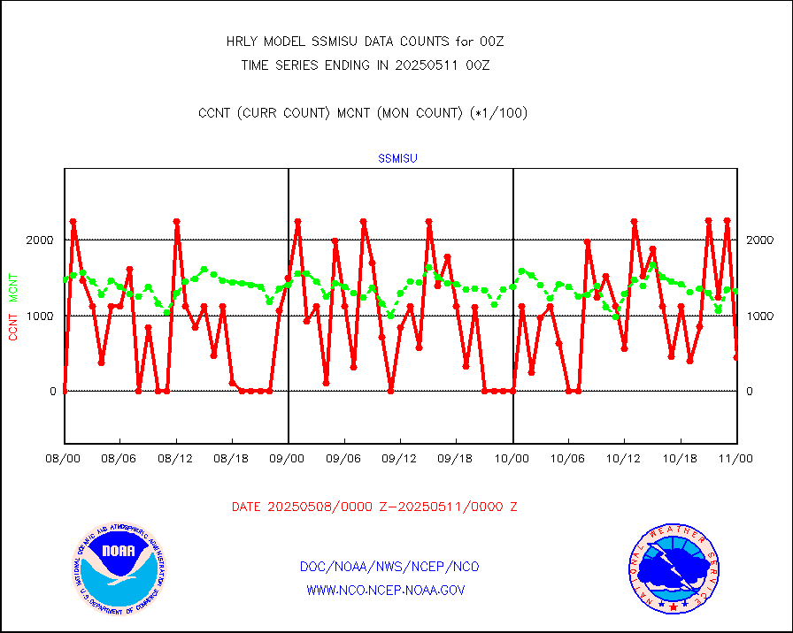
iasidb |
METOP 1-2 IASI 1C radiances-direct broadcast SSEC |
37258 |
37123 |
100.4 % |
1922.50-1923.49 |
ifvrnb |
VIIRS (NPP/NOAA-20) ir lg-wv drv cloud motion(NB) |
11355 |
16375 |
69.3 % |
1920.00-1920.99 |
infav |
AVHRR (NOAA/METOP) ir lg-wave derived cld motion |
0 |
0 |
n/a |
1920.00-1920.99 |
infav1 |
AVHRR (METOP) ir lg-wave derived cld motion |
0 |
0 |
n/a |
1923.50-2000.50 |
infin |
INSAT/KALPANA India ir lg-wave derived cld motion |
0 |
0 |
n/a |
1921.50-1922.49 |
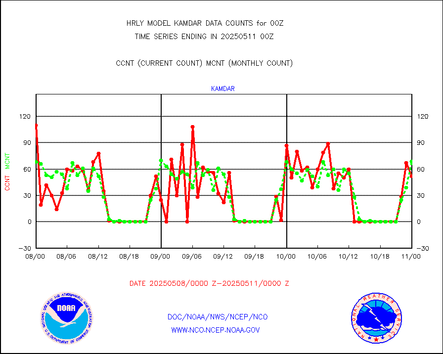
infin2 |
INDIA SATWIND, INSAT IR channel |
3430 |
2558 |
134.1 % |
1923.00-1923.99 |
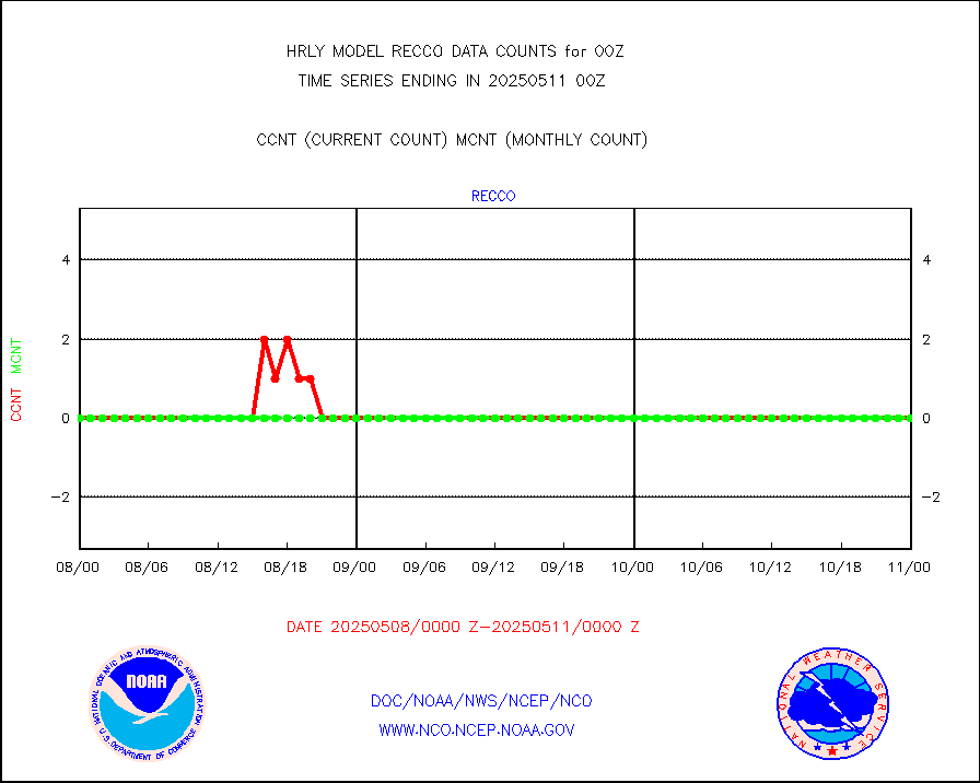
kamdar |
Korean AMDAR aircraft data (decoded from BUFR) |
30 |
53 |
56.6 % |
1923.50-2000.49 |
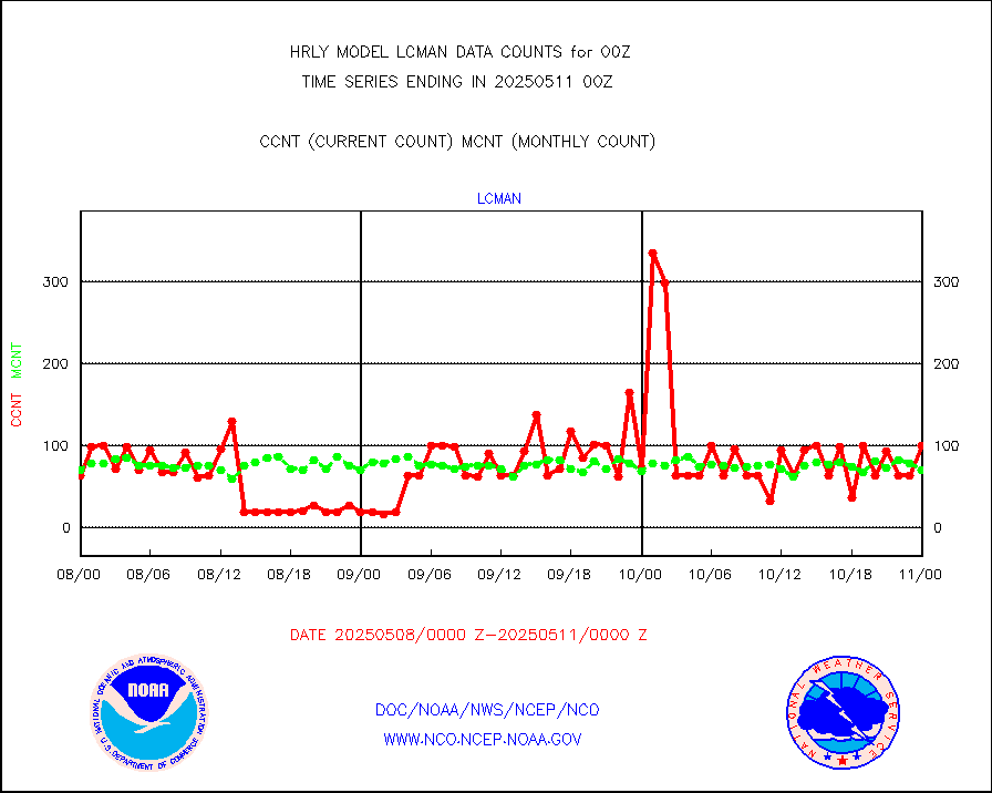
lcman |
Land-based CMAN stations decoded from CMAN format |
70 |
79 |
88.6 % |
1923.50-2000.49 |
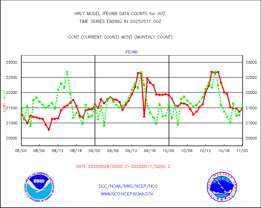
leogeo |
LEO-GEO satellite AMVs from UWisc. |
6364 |
5113 |
124.5 % |
1920.00-1920.99 |
ltnglr |
LLDN Long-rng lightning from Vaisala via NOAAPORT |
203952 |
187640 |
108.7 % |
1923.50-2000.49 |
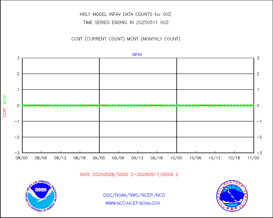
ltngsr |
NLDN Shrt-rng lightning from Vaisala via NOAAPORT |
12564 |
5213 |
241.0 % |
1923.50-2000.49 |
mbuoyb |
Moored buoys (decoded from BUFR) |
796 |
748 |
106.4 % |
1923.50-2000.50 |
mls |
Aura Microwave Limb Sounder (MLS) ozone data |
0 |
0 |
n/a |
1922.00-1922.99 |
msourb |
Mesonet/MADIS UrbaNet |
4364 |
4350 |
100.3 % |
1923.50-2000.49 |
nxrdw2 |
NEXRAD Vel Azm Dsp(VAD) winds via Level 2 decoder |
641 |
591 |
108.5 % |
1923.50-2000.49 |
ompslp |
OMPS Limb Profiler ozone data (NPP) |
357 |
271 |
131.7 % |
1917.00-1917.99 |
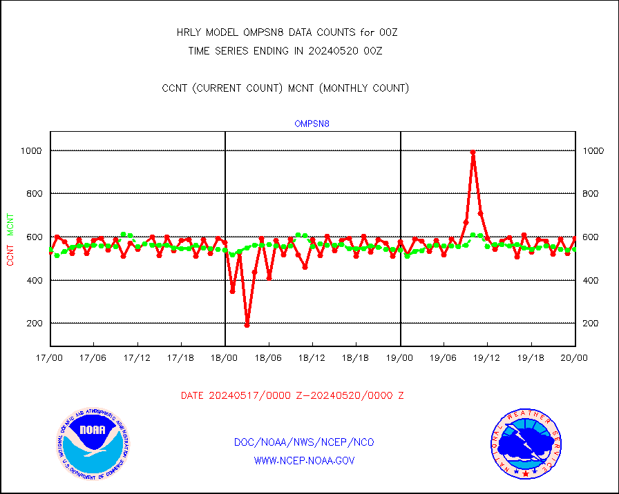
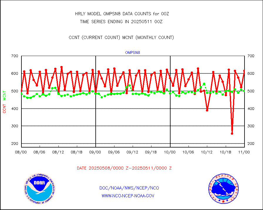
ompsn8 |
OMPS nadir profile ozone (Version 8 BUFR) |
594 |
541 |
109.8 % |
1922.00-1922.99 |
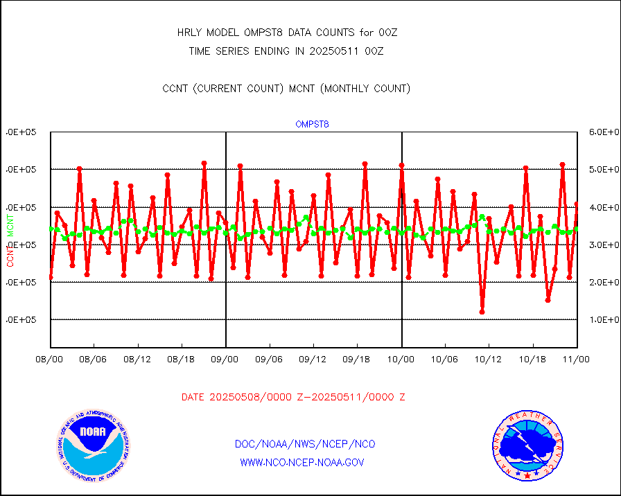
ompst8 |
OMPS total column ozone (Version 8 BUFR) |
221520 |
332575 |
66.6 % |
1922.00-1922.99 |
pirep |
Manual PIREP aircraft data (dcded from AIREP fmt) |
72 |
95 |
75.8 % |
1923.50-2000.49 |
prflrp |
Profilr winds from PIBAL (PILOT,PILOT SHIP/MOBIL) |
0 |
0 |
n/a |
1923.50-2000.49 |
raobm |
Rawinsonde - mobile land (from TEMP/PILOT MOBIL) |
0 |
0 |
n/a |
1923.50-2000.49 |
raobs |
Rawinsonde - ship (from TEMP SHIP, PILOT SHIP) |
0 |
0 |
n/a |
1923.50-2000.49 |
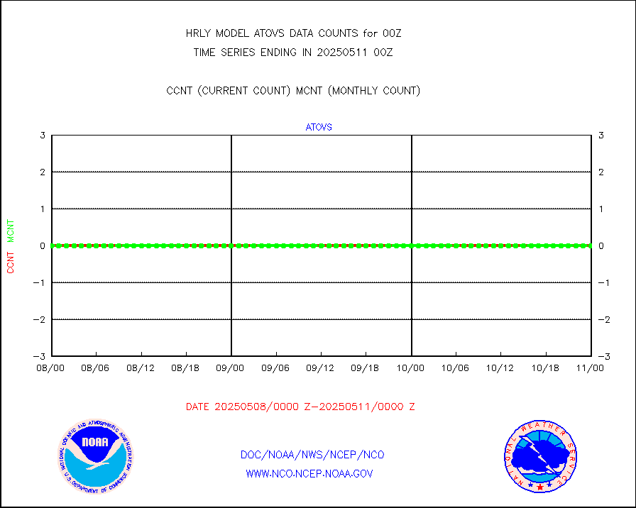
recco |
Flight level reconnaissance aircraft data |
0 |
0 |
n/a |
1923.50-2000.49 |
saphir |
Megha-Tropiques SAPHIR L1A2 brightness temps |
0 |
0 |
n/a |
1921.50-1922.49 |
sevasr |
METEOSAT-10 2nd Gen SEVIRI All Sky Radiance(proc) |
75512 |
75424 |
100.1 % |
1923.50-2000.49 |
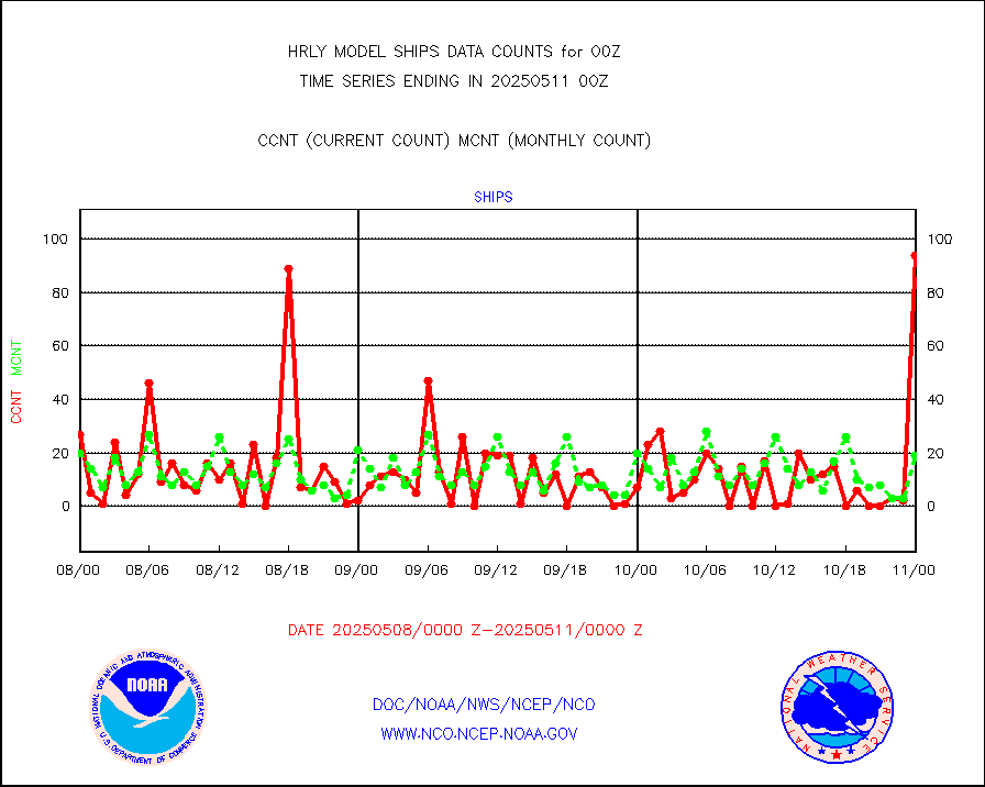
ships |
Ship - manual and automatic, restricted |
0 |
13 |
0.0 % |
1923.50-2000.49 |
ssmisu |
DMSP SSM/IS 1C radiance data (Unified Pre-Proc.) |
166800 |
113112 |
147.5 % |
1922.50-1923.49 |
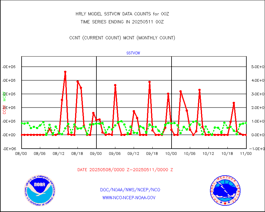
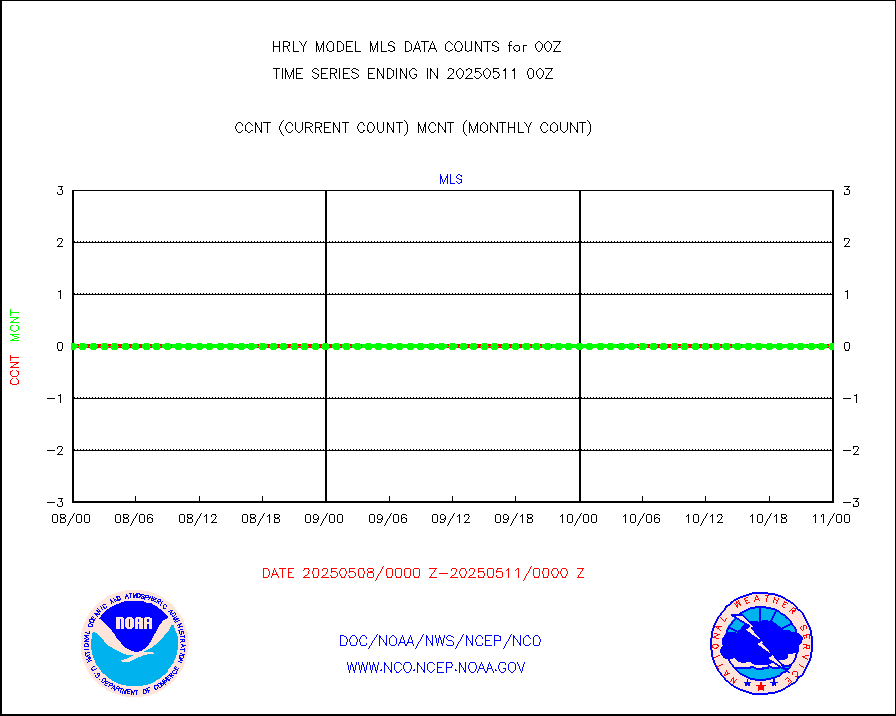
sstvcw |
NPP/NOAA-20 VIIRS SST - CLEAR & OVER WATER |
1752096 |
255950 |
684.5 % |
1923.50-2000.49 |
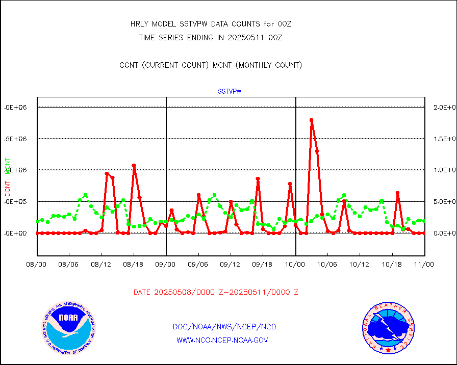
sstvpw |
NPP/NOAA-20 VIIRS SST - PROBABLY CLR & OVER WATER |
609178 |
111573 |
546.0 % |
1923.50-2000.49 |
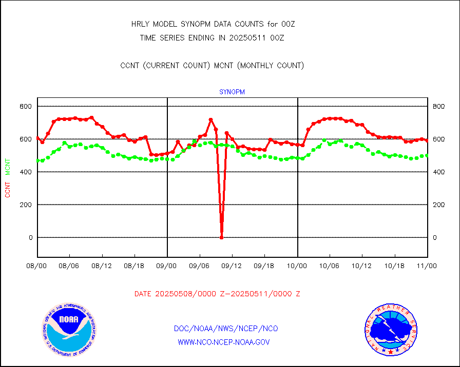
synopm |
Synoptic - mobile manual and automatic |
597 |
571 |
104.6 % |
1923.50-2000.49 |
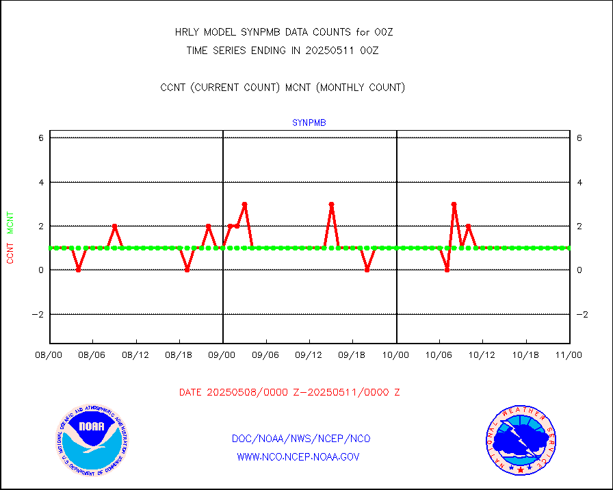
synpmb |
Synoptic - mobile manual & auto (decoded fr BUFR) |
0 |
1 |
0.0 % |
1923.50-2000.49 |
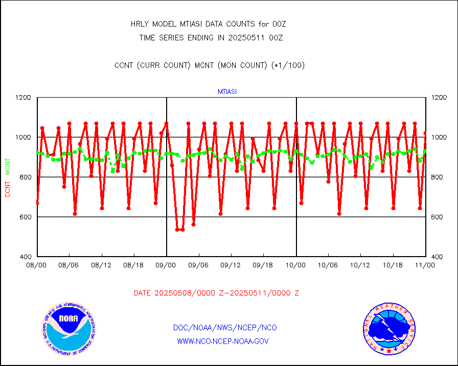
tesac |
CTD probe, Argo prflng float, mooring (TESAC fmt) |
198 |
188 |
105.3 % |
1923.50-2000.49 |
tmdara |
TAMDAR aircft data-all types(from Panasonic,BUFR) |
233 |
315 |
74.0 % |
1923.50-2000.49 |
trkob |
ThermoSalinoGraph (TSG) TRACKOB format) |
90 |
42 |
214.3 % |
1922.50-1923.49 |
visin |
INSAT/KALPANA India visible derived cloud motion |
0 |
0 |
n/a |
1921.50-1922.49 |
visin2 |
INDIA SATWIND, INSAT VIS channel |
0 |
0 |
n/a |
1923.00-1923.99 |
visja |
MTSAT/JMA visible derived cloud motion |
8063 |
8023 |
100.5 % |
1921.50-1922.49 |
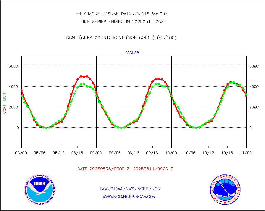
visusr |
GOES-16&up/NESDIS visible derived cloud motion |
296128 |
303432 |
97.6 % |
1923.00-1923.99 |
vseunb |
METEOSAT/EUMETSAT visible drv cld motion NBseq |
0 |
0 |
n/a |
1922.50-1923.49 |


